Recently Published Bulletin Reports
Manam (Papua New Guinea) Few ash plumes during November-December 2022
Krakatau (Indonesia) Strombolian activity and ash plumes during November 2022-April 2023
Stromboli (Italy) Strombolian explosions and lava flows continue during January-April 2023
Nishinoshima (Japan) Small ash plumes and fumarolic activity during November 2022 through April 2023
Karangetang (Indonesia) Lava flows, incandescent avalanches, and ash plumes during January-June 2023
Ahyi (United States) Intermittent hydroacoustic signals and discolored plumes during November 2022-June 2023
Kadovar (Papua New Guinea) An ash plume and weak thermal anomaly during May 2023
San Miguel (El Salvador) Small gas-and-ash explosions during March and May 2023
Semisopochnoi (United States) Occasional explosions, ash deposits, and gas-and-steam plumes during December 2022-May 2023
Ebeko (Russia) Continued explosions, ash plumes, and ashfall during October 2022-May 2023
Home Reef (Tonga) Discolored plumes continued during November 2022-April 2023
Ambae (Vanuatu) New lava flow, ash plumes, and sulfur dioxide plumes during February-May 2023
Manam (Papua New Guinea) — July 2023  Cite this Report
Manam
Papua New Guinea
4.08°S, 145.037°E; summit elev. 1807 m
All times are local (unless otherwise noted)
Few ash plumes during November-December 2022
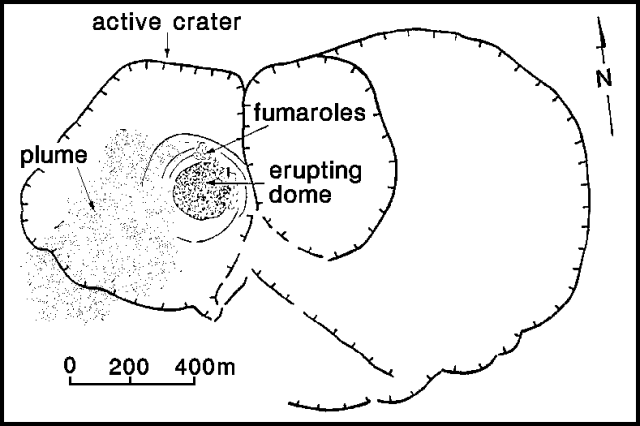
Manam is a 10-km-wide island that consists of two active summit craters: the Main summit crater and the South summit crater and is located 13 km off the northern coast of mainland Papua New Guinea. Frequent mild-to-moderate eruptions have been recorded since 1616. The current eruption period began during June 2014 and has more recently been characterized by intermittent ash plumes and thermal activity (BGVN 47:11). This report updates activity that occurred from November 2022 through May 2023 based on information from the Darwin Volcanic Ash Advisory Center (VAAC) and various satellite data.
Ash plumes were reported during November and December 2022 by the Darwin VAAC. On 7 November an ash plume rose to 2.1 km altitude and drifted NE based on satellite images and weather models. On 14 November an ash plume rose to 2.1 km altitude and drifted W based on RVO webcam images. On 20 November ash plumes rose to 1.8 km altitude and drifted NW. On 26 December an ash plume rose to 3 km altitude and drifted S and SSE.
Intermittent sulfur dioxide plumes were detected using the TROPOMI instrument on the Sentinel-5P satellite, some of which exceeded at least two Dobson Units (DU) and drifted in different directions (figure 93). Occasional low-to-moderate power thermal anomalies were recorded by the MIROVA (Middle InfraRed Observation of Volcanic Activity) system; less than five anomalies were recorded each month during November 2022 through May 2023 (figure 94). Two thermal hotspots were detected by the MODVOLC thermal alerts system on 10 December 2022. On clear weather days, thermal activity was also captured in infrared satellite imagery in both the Main and South summit craters, accompanied by gas-and-steam emissions (figure 95).
Geologic Background. The 10-km-wide island of Manam, lying 13 km off the northern coast of mainland Papua New Guinea, is one of the country's most active volcanoes. Four large radial valleys extend from the unvegetated summit of the conical basaltic-andesitic stratovolcano to its lower flanks. These valleys channel lava flows and pyroclastic avalanches that have sometimes reached the coast. Five small satellitic centers are located near the island's shoreline on the northern, southern, and western sides. Two summit craters are present; both are active, although most observed eruptions have originated from the southern crater, concentrating eruptive products during much of the past century into the SE valley. Frequent eruptions, typically of mild-to-moderate scale, have been recorded since 1616. Occasional larger eruptions have produced pyroclastic flows and lava flows that reached flat-lying coastal areas and entered the sea, sometimes impacting populated areas.
Information Contacts: Rabaul Volcano Observatory (RVO), Geohazards Management Division, Department of Mineral Policy and Geohazards Management (DMPGM), PO Box 3386, Kokopo, East New Britain Province, Papua New Guinea; Darwin Volcanic Ash Advisory Centre (VAAC), Bureau of Meteorology, Northern Territory Regional Office, PO Box 40050, Casuarina, NT 0811, Australia (URL: http://www.bom.gov.au/info/vaac/); MIROVA (Middle InfraRed Observation of Volcanic Activity), a collaborative project between the Universities of Turin and Florence (Italy) supported by the Centre for Volcanic Risk of the Italian Civil Protection Department (URL: http://www.mirovaweb.it/); Hawai'i Institute of Geophysics and Planetology (HIGP) - MODVOLC Thermal Alerts System, School of Ocean and Earth Science and Technology (SOEST), Univ. of Hawai'i, 2525 Correa Road, Honolulu, HI 96822, USA (URL: http://modis.higp.hawaii.edu/); NASA Global Sulfur Dioxide Monitoring Page, Atmospheric Chemistry and Dynamics Laboratory, NASA Goddard Space Flight Center (NASA/GSFC), 8800 Greenbelt Road, Goddard, Maryland, USA (URL: https://so2.gsfc.nasa.gov/); Copernicus Browser, Copernicus Data Space Ecosystem, European Space Agency (URL: https://dataspace.copernicus.eu/browser/).
Krakatau (Indonesia) — July 2023 Cite this Report
Krakatau
Indonesia
6.1009°S, 105.4233°E; summit elev. 285 m
All times are local (unless otherwise noted)
Strombolian activity and ash plumes during November 2022-April 2023
Krakatau is located in the Sunda Strait between Java and Sumatra, Indonesia. Caldera collapse during the catastrophic 1883 eruption destroyed Danan and Perbuwatan cones and left only a remnant of Rakata. The post-collapse cone of Anak Krakatau (Child of Krakatau) was constructed within the 1883 caldera at a point between the former Danan and Perbuwatan cones; it has been the site of frequent eruptions since 1927. The current eruption period began in May 2021 and has recently consisted of explosions, ash plumes, and thermal activity (BGVN 47:11). This report covers activity during November 2022 through April 2023 based on information provided by the Indonesian Center for Volcanology and Geological Hazard Mitigation, referred to as Pusat Vulkanologi dan Mitigasi Bencana Geologi (PVMBG), MAGMA Indonesia, the Darwin Volcanic Ash Advisory Center (VAAC), and several sources of satellite data.
Activity was relatively low during November and December 2022. Daily white gas-and-steam plumes rose 25-100 m above the summit and drifted in different directions. Gray ash plumes rose 200 m above the summit and drifted NE at 1047 and at 2343 on 11 November. On 14 November at 0933 ash plumes rose 300 m above the summit and drifted E. An ash plume was reported at 0935 on 15 December that rose 100 m above the summit and drifted NE. An eruptive event at 1031 later that day generated an ash plume that rose 700 m above the summit and drifted NE. A gray ash plume at 1910 rose 100 m above the summit and drifted E. Incandescent material was ejected above the vent based on an image taken at 1936.
During January 2023 daily white gas-and-steam plumes rose 25-300 m above the summit and drifted in multiple directions. Gray-to-brown ash plumes were reported at 1638 on 3 January, at 1410 and 1509 on 4 January, and at 0013 on 5 January that rose 100-750 m above the summit and drifted NE and E; the gray-to-black ash plume at 1509 on 4 January rose as high as 3 km above the summit and drifted E. Gray ash plumes were recorded at 1754, 2241, and 2325 on 11 January and at 0046 on 12 January and rose 200-300 m above the summit and drifted NE. Toward the end of January, PVMBG reported that activity had intensified; Strombolian activity was visible in webcam images taken at 0041, 0043, and 0450 on 23 January. Multiple gray ash plumes throughout the day rose 200-500 m above the summit and drifted E and SE (figure 135). Webcam images showed progressively intensifying Strombolian activity at 1919, 1958, and 2113 on 24 January; a gray ash plume at 1957 rose 300 m above the summit and drifted E (figure 135). Eruptive events at 0231 and 2256 on 25 January and at 0003 on 26 January ejected incandescent material from the vent, based on webcam images. Gray ash plumes observed during 26-27 January rose 300-500 m above the summit and drifted NE, E, and SE.
Low levels of activity were reported during February and March. Daily white gas-and-steam plumes rose 25-300 m above the summit and drifted in different directions. The Darwin VAAC reported that continuous ash emissions rose to 1.5-1.8 km altitude and drifted W and NW during 1240-1300 on 10 March, based on satellite images, weather models, and PVMBG webcams. White-and-gray ash plumes rose 500 m and 300 m above the summit and drifted SW at 1446 and 1846 on 18 March, respectively. An eruptive event was recorded at 2143, though it was not visible due to darkness. Multiple ash plumes were reported during 27-29 March that rose as high as 2.5 km above the summit and drifted NE, W, and SW (figure 136). Webcam images captured incandescent ejecta above the vent at 0415 and around the summit area at 2003 on 28 March and at 0047 above the vent on 29 March.
Daily white gas-and-steam plumes rose 25-300 m above the summit and drifted in multiple directions during April and May. White-and-gray and black plumes rose 50-300 m above the summit on 2 and 9 April. On 11 May at 1241 a gray ash plume rose 1-3 km above the summit and drifted SW. On 12 May at 0920 a gray ash plume rose 2.5 km above the summit and drifted SW and at 2320 an ash plume rose 1.5 km above the summit and drifted SW. An accompanying webcam image showed incandescent ejecta. On 13 May at 0710 a gray ash plume rose 2 km above the summit and drifted SW (figure 137).
The MIROVA (Middle InfraRed Observation of Volcanic Activity) graph of MODIS thermal anomaly data showed intermittent low-to-moderate power thermal anomalies during November 2022 through April 2023 (figure 138). Some of this thermal activity was also visible in infrared satellite imagery at the crater, accompanied by gas-and-steam and ash plumes that drifted in different directions (figure 139).
Geologic Background. The renowned Krakatau (frequently mis-named as Krakatoa) volcano lies in the Sunda Strait between Java and Sumatra. Collapse of an older edifice, perhaps in 416 or 535 CE, formed a 7-km-wide caldera. Remnants of that volcano are preserved in Verlaten and Lang Islands; subsequently the Rakata, Danan, and Perbuwatan cones were formed, coalescing to create the pre-1883 Krakatau Island. Caldera collapse during the catastrophic 1883 eruption destroyed Danan and Perbuwatan, and left only a remnant of Rakata. This eruption caused more than 36,000 fatalities, most as a result of tsunamis that swept the adjacent coastlines of Sumatra and Java. Pyroclastic surges traveled 40 km across the Sunda Strait and reached the Sumatra coast. After a quiescence of less than a half century, the post-collapse cone of Anak Krakatau (Child of Krakatau) was constructed within the 1883 caldera at a point between the former Danan and Perbuwatan cones. Anak Krakatau has been the site of frequent eruptions since 1927.
Information Contacts: Pusat Vulkanologi dan Mitigasi Bencana Geologi (PVMBG, also known as Indonesian Center for Volcanology and Geological Hazard Mitigation, CVGHM), Jalan Diponegoro 57, Bandung 40122, Indonesia (URL: http://www.vsi.esdm.go.id/); MAGMA Indonesia, Kementerian Energi dan Sumber Daya Mineral (URL: https://magma.esdm.go.id/v1); Darwin Volcanic Ash Advisory Centre (VAAC), Bureau of Meteorology, Northern Territory Regional Office, PO Box 40050, Casuarina, NT 0811, Australia (URL: http://www.bom.gov.au/info/vaac/); MIROVA (Middle InfraRed Observation of Volcanic Activity), a collaborative project between the Universities of Turin and Florence (Italy) supported by the Centre for Volcanic Risk of the Italian Civil Protection Department (URL: http://www.mirovaweb.it/); Copernicus Browser, Copernicus Data Space Ecosystem, European Space Agency (URL: https://dataspace.copernicus.eu/browser/).
Stromboli
Italy
38.789°N, 15.213°E; summit elev. 924 m
All times are local (unless otherwise noted)
Strombolian explosions and lava flows continue during January-April 2023
Stromboli, located in Italy, has exhibited nearly constant lava fountains for the past 2,000 years; recorded eruptions date back to 350 BCE. Eruptive activity occurs at the summit from multiple vents, which include a north crater area (N area) and a central-southern crater (CS area) on a terrace known as the ‘terrazza craterica’ at the head of the Sciara del Fuoco, a large scarp that runs from the summit down the NW side of the volcano-island. Activity typically consists of Strombolian explosions, incandescent ejecta, lava flows, and pyroclastic flows. Thermal and visual monitoring cameras are located on the nearby Pizzo Sopra La Fossa, above the terrazza craterica, and at multiple flank locations. The current eruption period has been ongoing since 1934 and recent activity has consisted of frequent Strombolian explosions and lava flows (BGVN 48:02). This report updates activity during January through April 2023 primarily characterized by Strombolian explosions and lava flows based on reports from Italy's Istituto Nazionale di Geofisica e Vulcanologia (INGV) and various satellite data.
Frequent explosive activity continued throughout the reporting period, generally in the low-to-medium range, based on the number of hourly explosions in the summit crater (figure 253, table 16). Intermittent thermal activity was recorded by the MIROVA (Middle InfraRed Observation of Volcanic Activity) analysis of MODIS satellite data (figure 254). According to data collected by the MODVOLC thermal algorithm, a total of 9 thermal alerts were detected: one on 2 January 2023, one on 1 February, five on 24 March, and two on 26 March. The stronger pulses of thermal activity likely reflected lava flow events. Infrared satellite imagery captured relatively strong thermal hotspots at the two active summit craters on clear weather days, showing an especially strong event on 8 March (figure 255).
Table 16. Summary of type, frequency, and intensity of explosive activity at Stromboli by month during January-April 2023; information from webcam observations. Courtesy of INGV weekly reports.
| Month |
Explosive Activity |
| Jan 2023 |
Typical Strombolian activity with spattering and lava overflows in the N crater area. Explosions were reported from 4 vents in the N area and 1-2 vents in the CS area. The average hourly frequency of explosions was low-to-medium (1-12 events/hour). The intensity of the explosions varied from low (less than 80 m high) to medium (less than 150 m high) in the N crater area and up to high (greater than 150 m high) in the CS crater area. |
| Feb 2023 |
Typical Strombolian activity with spattering in the N crater area. Explosions were reported from 2-3 vents in the N area and 1-4 vents in the CS area. The average hourly frequency of explosions was low-to-medium (1-14 events/hour). The intensity of the explosions varied from low (less than 80 m high) to medium (less than 150 m high) in the N crater area and up to high (greater than 150 m high) in the CS crater area. |
| Mar 2023 |
Typical Strombolian activity with spattering and lava overflows in the N crater area. Explosions were reported from 2-3 vents in the N area and 2-4 vents in the CS area. The average hourly frequency of explosions was low-to-medium (1-18 events/hour). The intensity of the explosions varied from low (less than 80 m high) to medium (less than 150 m high) in the N crater area and up to high (greater than 150 m high) in the CS crater area. |
| Apr 2023 |
Typical Strombolian activity. Explosions were reported from 2 vents in the N area and 2-3 vents in the CS area. The average hourly frequency of explosions was low-to-high (1-16 events/hour). The intensity of the explosions varied from low (less than 80 m high) to medium (less than 150 m high) in both the N and CS crater areas. |
Activity during January-February 2023. Strombolian explosions were reported in the N crater area, as well as lava effusion. Explosive activity in the N crater area ejected coarse material (bombs and lapilli). Intense spattering was observed in both the N1 and N2 craters. In the CS crater area, explosions generally ejected fine material (ash), sometimes to heights greater than 250 m. The intensity of the explosions was characterized as low-to-medium in the N crater and medium-to-high in the CS crater. After intense spattering activity from the N crater area, a lava overflow began at 2136 on 2 January that flowed part way down the Sciara del Fuoco, possibly moving down the drainage that formed in October, out of view from webcams. The flow remained active for a couple of hours before stopping and beginning to cool. A second lava flow was reported at 0224 on 4 January that similarly remained active for a few hours before stopping and cooling. Intense spattering was observed on 11 and 13 January from the N1 crater. After intense spattering activity at the N2 crater at 1052 on 17 January another lava flow started to flow into the upper part of the Sciara del Fuoco (figure 256), dividing into two: one that traveled in the direction of the drainage formed in October, and the other one moving parallel to the point of emission. By the afternoon, the rate of the flow began to decrease, and at 1900 it started to cool. A lava flow was reported at 1519 on 24 January following intense spattering in the N2 area, which began to flow into the upper part of the Sciara del Fuoco. By the morning of 25 January, the lava flow had begun to cool. During 27 January the frequency of eruption in the CS crater area increased to 6-7 events/hour compared to the typical 1-7 events/hour; the following two days showed a decrease in frequency to less than 1 event/hour. Starting at 1007 on 30 January a high-energy explosive sequence was produced by vents in the CS crater area. The sequence began with an initial energetic pulse that lasted 45 seconds, ejecting predominantly coarse products 300 m above the crater that fell in an ESE direction. Subsequent and less intense explosions ejected material 100 m above the crater. The total duration of this event lasted approximately two minutes. During 31 January through 6, 13, and 24 February spattering activity was particularly intense for short periods in the N2 crater.
An explosive sequence was reported on 16 February that was characterized by a major explosion in the CS crater area (figure 257). The sequence began at 1817 near the S2 crater that ejected material radially. A few seconds later, lava fountains were observed in the central part of the crater. Three explosions of medium intensity (material was ejected less than 150 m high) were recorded at the S2 crater. The first part of this sequence lasted approximately one minute, according to INGV, and material rose 300 m above the crater and then was deposited along the Sciara del Fuoco. The second phase began at 1818 at the S1 crater; it lasted seven seconds and material was ejected 150 m above the crater. Another event 20 seconds later lasted 12 seconds, also ejecting material 150 m above the crater. The sequence ended with at least three explosions of mostly fine material from the S1 crater. The total duration of this sequence was about two minutes.
Short, intense spattering activity was noted above the N1 crater on 27 and 28 February. A lava overflow was first reported at 0657 from the N2 crater on 27 February that flowed into the October 2022 drainage. By 1900 the flow had stopped. A second lava overflow also in the N crater area occurred at 2149, which overlapped the first flow and then stopped by 0150 on 28 February. Material detached from both the lava overflows rolled down the Sciara del Fuoco, some of which was visible in webcam images.
Activity during March-April 2023. Strombolian activity continued with spattering activity and lava overflows in the N crater area during March. Explosive activity at the N crater area varied from low (less than 80 m high) to medium (less than 150 m high) and ejected coarse material, such as bombs and lapilli. Spattering was observed above the N1 crater, while explosive activity at the CS crater area varied from medium to high (greater than 150 m high) and ejected coarse material. Intense spattering activity was observed for short periods on 6 March above the N1 crater. At approximately 0610 a lava overflow was reported around the N2 crater on 8 March, which then flowed into the October 2022 drainage. By 1700 the flow started to cool. A second overflow began at 1712 on 9 March and overlapped the previous flow. It had stopped by 2100. Material from both flows was deposited along the Sciara del Fuoco, though much of the activity was not visible in webcam images. On 11 March a lava overflow was observed at 0215 that overlapped the two previous flows in the October 2022 drainage. By late afternoon on 12 March, it had stopped.
During a field excursion on 16 March, scientists noted that a vent in the central crater area was degassing. Another vent showed occasional Strombolian activity that emitted ash and lapilli. During 1200-1430 low-to-medium intense activity was reported; the N1 crater emitted ash emissions and the N2 crater emitted both ash and coarse material. Some explosions also occurred in the CS crater area that ejected coarse material. The C crater in the CS crater area occasionally showed gas jetting and low intensity explosions on 17 and 22 March; no activity was observed at the S1 crater. Intense, longer periods of spattering were reported in the N1 crater on 19, 24, and 25 March. Around 2242 on 23 March a lava overflow began from the N1 crater that, after about an hour, began moving down the October 2022 drainage and flow along the Sciara del Fuoco (figure 258). Between 0200 and 0400 on 26 March the flow rate increased, which generated avalanches of material from collapses at the advancing flow front. By early afternoon, the flow began to cool. On 25 March at 1548 an explosive sequence began from one of the vents at S2 in the CS crater area (figure 258). Fine ash mixed with coarse material was ejected 300 m above the crater rim and drifted SSE. Some modest explosions around Vent C were detected at 1549 on 25 March, which included an explosion at 1551 that ejected coarse material. The entire explosive sequence lasted approximately three minutes.
During April explosions persisted in both the N and CS crater areas. Fine material was ejected less than 80 m above the N crater rim until 6 April, followed by ejection of coarser material. Fine material was also ejected less than 80 m above the CS crater rim. The C and S2 crater did not show significant eruptive activity. On 7 April an explosive sequence was detected in the CS crater area at 1203 (figure 259). The first explosion lasted approximately 18 seconds and ejected material 400 m above the crater rim, depositing pyroclastic material in the upper part of the Sciara del Fuoco. At 1204 a second, less intense explosion lasted approximately four seconds and deposited pyroclastic products outside the crater area and near Pizzo Sopra La Fossa. A third explosion at 1205 was mainly composed of ash that rose about 150 m above the crater and lasted roughly 20 seconds. A fourth explosion occurred at 1205 about 28 seconds after the third explosion and ejected a mixture of coarse and fine material about 200 m above the crater; the explosion lasted roughly seven seconds. Overall, the entire explosive sequence lasted about two minutes and 20 seconds. After the explosive sequence on 7 April, explosions in both the N and CS crater areas ejected material as high as 150 m above the crater.
On 21 April research scientists from INGV made field observations in the summit area of Stromboli, and some lapilli samples were collected. In the N crater area near the N1 crater, a small cone was observed with at least two active vents, one of which was characterized by Strombolian explosions. The other vent produced explosions that ejected ash and chunks of cooled lava. At the N2 crater at least one vent was active and frequently emitted ash. In the CS crater area, a small cone contained 2-3 degassing vents and a smaller, possible fissure area also showed signs of degassing close to the Pizzo Sopra La Fossa. In the S part of the crater, three vents were active: a small hornito was characterized by modest and rare explosions, a vent that intermittently produced weak Strombolian explosions, and a vent at the end of the terrace that produced frequent ash emissions. Near the S1 crater there was a hornito that generally emitted weak gas-and-steam emissions, sometimes associated with “gas rings”. On 22 April another field inspection was carried out that reported two large sliding surfaces on the Sciara del Fuoco that showed where blocks frequently descended toward the sea. A thermal anomaly was detected at 0150 on 29 April.
Geologic Background. Spectacular incandescent nighttime explosions at Stromboli have long attracted visitors to the "Lighthouse of the Mediterranean" in the NE Aeolian Islands. This volcano has lent its name to the frequent mild explosive activity that has characterized its eruptions throughout much of historical time. The small island is the emergent summit of a volcano that grew in two main eruptive cycles, the last of which formed the western portion of the island. The Neostromboli eruptive period took place between about 13,000 and 5,000 years ago. The active summit vents are located at the head of the Sciara del Fuoco, a prominent scarp that formed about 5,000 years ago due to a series of slope failures which extends to below sea level. The modern volcano has been constructed within this scarp, which funnels pyroclastic ejecta and lava flows to the NW. Essentially continuous mild Strombolian explosions, sometimes accompanied by lava flows, have been recorded for more than a millennium.
Information Contacts: Istituto Nazionale di Geofisica e Vulcanologia (INGV), Sezione di Catania, Piazza Roma 2, 95123 Catania, Italy, (URL: http://www.ct.ingv.it/en/); MIROVA (Middle InfraRed Observation of Volcanic Activity), a collaborative project between the Universities of Turin and Florence (Italy) supported by the Centre for Volcanic Risk of the Italian Civil Protection Department (URL: http://www.mirovaweb.it/); Hawai'i Institute of Geophysics and Planetology (HIGP) - MODVOLC Thermal Alerts System, School of Ocean and Earth Science and Technology (SOEST), Univ. of Hawai'i, 2525 Correa Road, Honolulu, HI 96822, USA (URL: http://modis.higp.hawaii.edu/); Copernicus Browser, Copernicus Data Space Ecosystem, European Space Agency (URL: https://dataspace.copernicus.eu/browser/).
Nishinoshima (Japan) — July 2023 Cite this Report
Nishinoshima
Japan
27.247°N, 140.874°E; summit elev. 100 m
All times are local (unless otherwise noted)
Small ash plumes and fumarolic activity during November 2022 through April 2023
Nishinoshima is a small island located about 1,000 km S of Tokyo in the Ogasawara Arc in Japan. The island is the summit of a massive submarine volcano that has prominent peaks to the S, W, and NE. Eruptions date back to 1973; the most recent eruption period began in October 2022 and was characterized by ash plumes and fumarolic activity (BGVN 47:12). This report describes ash plumes and fumarolic activity during November 2022 through April 2023 based on monthly reports from the Japan Meteorological Agency (JMA) monthly reports and satellite data.
The most recent eruptive activity prior to the reporting internal occurred on 12 October 2022, when an ash plume rose 3.5 km above the crater rim. An aerial observation conducted by the Japan Coast Guard (JCG) on 25 November reported that white fumaroles rose approximately 200 m above the central crater of a pyroclastic cone (figure 119), and multiple plumes were observed on the ESE flank of the cone. Discolored water ranging from reddish-brown to brown and yellowish-green were visible around the perimeter of the island (figure 119). No significant activity was reported in December.
During an overflight conducted by JCG on 25 January 2023 intermittent activity and small, blackish-gray plumes rose 900 m above the central part of the crater were observed (figure 120). The fumarolic zone of the E flank and base of the cone had expanded and emissions had intensified. Dark brown discolored water was visible around the perimeter of the island.
No significant activity was reported during February through March. Ash plumes at 1050 and 1420 on 11 April rose 1.9 km above the crater rim and drifted NW and N. These were the first ash plumes observed since 12 October 2022. On 14 April JCG carried out an overflight and reported that no further eruptive activity was visible, although white gas-and-steam plumes were visible from the central crater and rose 900 m high (figure 121). Brownish and yellow-green discolored water surrounded the island.
Intermittent low-to-moderate power thermal anomalies were recorded in the MIROVA graph (Middle InfraRed Observation of Volcanic Activity) during November 2022 through April 2023 (figure 123). A cluster of six to eight anomalies were detected during November while a smaller number were detected during the following months: two to three during December, one during mid-January 2023, one during February, five during March, and two during April. Thermal activity was also reflected in infrared satellite data at the summit crater, accompanied by occasional gas-and-steam plumes (figure 124).
Geologic Background. The small island of Nishinoshima was enlarged when several new islands coalesced during an eruption in 1973-74. Multiple eruptions that began in 2013 completely covered the previous exposed surface and continued to enlarge the island. The island is the summit of a massive submarine volcano that has prominent peaks to the S, W, and NE. The summit of the southern cone rises to within 214 m of the ocean surface 9 km SSE.
Information Contacts: Japan Meteorological Agency (JMA), 1-3-4 Otemachi, Chiyoda-ku, Tokyo 100-8122, Japan (URL: http://www.jma.go.jp/jma/indexe.html); MIROVA (Middle InfraRed Observation of Volcanic Activity), a collaborative project between the Universities of Turin and Florence (Italy) supported by the Centre for Volcanic Risk of the Italian Civil Protection Department (URL: http://www.mirovaweb.it/); Copernicus Browser, Copernicus Data Space Ecosystem, European Space Agency (URL: https://dataspace.copernicus.eu/browser/).
Karangetang (Indonesia) — July 2023 Cite this Report
Karangetang
Indonesia
2.781°N, 125.407°E; summit elev. 1797 m
All times are local (unless otherwise noted)
Lava flows, incandescent avalanches, and ash plumes during January-June 2023
Karangetang (also known as Api Siau), at the northern end of the island of Siau, Indonesia, contains five summit craters along a N-S line. More than 40 eruptions have been recorded since 1675; recent eruptions have included frequent explosive activity, sometimes accompanied by pyroclastic flows and lahars. Lava dome growth has occurred in the summit craters and collapses of lava flow fronts have produced pyroclastic flows. The two active summit craters are Kawah Dua (the N crater) and Kawah Utama (the S crater, also referred to as the “Main Crater”). The most recent eruption began in late November 2018 and has more recently consisted of weak thermal activity and gas-and-steam emissions (BGVN 48:01). This report updates activity characterized by lava flows, incandescent avalanches, and ash plumes during January through June 2023 using reports from Pusat Vulkanologi dan Mitigasi Bencana Geologi (PVMBG, also known as CVGHM, or the Center of Volcanology and Geological Hazard Mitigation), MAGMA Indonesia, the Darwin VAAC (Volcano Ash Advisory Center), and satellite data.
Activity during January was relatively low and mainly consisted of white gas-and-steam emissions that rose 25-150 m above Main Crater (S crater) and drifted in different directions. Incandescence was visible from the lava dome in Kawah Dua (the N crater). Weather conditions often prevented clear views of the summit. On 18 January the number of seismic signals that indicated avalanches of material began to increase. In addition, there were a total of 71 earthquakes detected during the month.
Activity continued to increase during the first week of February. Material from Main Crater traveled as far as 800 m down the Batuawang (S) and Batang (W) drainages and as far as 1 km W down the Beha (W) drainage on 4 February. On 6 February 43 earthquake events were recorded, and on 7 February, 62 events were recorded. White gas-and-steam emissions rose 25-250 m above both summit craters throughout the month. PVMBG reported an eruption began during the evening of 8 February around 1700. Photos showed incandescent material at Main Crater. Incandescent material had also descended the flank in at least two unconfirmed directions as far as 2 km from Main Crater, accompanied by ash plumes (figure 60). As a result, PVMBG increased the Volcano Alert Level (VAL) to 3 (the second highest level on a 1-4 scale).
Occasional nighttime webcam images showed three main incandescent lava flows of differing lengths traveling down the S, SW, and W flanks (figure 61). Incandescent rocks were visible on the upper flanks, possibly from ejected or collapsed material from the crater, and incandescence was the most intense at the summit. Based on analyses of satellite imagery and weather models, the Darwin VAAC reported that daily ash plumes during 16-20 February rose to 2.1-3 km altitude and drifted NNE, E, and SE. BNPB reported on 16 February that as many as 77 people were evacuated and relocated to the East Siau Museum. A webcam image taken at 2156 on 17 February possibly showed incandescent material descending the SE flank. Ash plumes rose to 2.1 km altitude and drifted SE during 22-23 February, according to the Darwin VAAC.
Incandescent avalanches of material and summit incandescence at Main Crater continued during March. White gas-and-steam emissions during March generally rose 25-150 m above the summit crater; on 31 March gas-and-steam emissions rose 200-400 m high. An ash plume rose to 2.4 km altitude and drifted S at 1710 on 9 March and a large thermal anomaly was visible in images taken at 0550 and 0930 on 10 March. Incandescent material was visible at the summit and on the flanks based on webcam images taken at 0007 and 2345 on 16 March, at 1828 on 17 March, at 1940 on 18 March, at 2311 on 19 March, and at 2351 on 20 March. Incandescence was most intense on 18 and 20 March and webcam images showed possible Strombolian explosions (figure 62). An ash plume rose to 2.4 km altitude and drifted SW on 18 March, accompanied by a thermal anomaly.
Summit crater incandescence at Main Crater and on the flanks persisted during April. Incandescent material at the S crater and on the flanks was reported at 0016 on 1 April. The lava flows had stopped by 1 April according to PVMBG, although incandescence was still visible up to 10 m high. Seismic signals indicating effusion decreased and by 6 April they were no longer detected. Incandescence was visible from both summit craters. On 26 April the VAL was lowered to 2 (the second lowest level on a 1-4 scale). White gas-and-steam emissions rose 25-200 m above the summit crater.
During May white gas-and-steam emissions generally rose 50-250 m above the summit, though it was often cloudy, which prevented clear views; on 21 May gas-and-steam emissions rose 50-400 m high. Nighttime N summit crater incandescence rose 10-25 m above the lava dome, and less intense incandescence was noted above Main Crater, which reached about 10 m above the dome. Sounds of falling rocks at Main Crater were heard on 15 May and the seismic network recorded 32 rockfall events in the crater on 17 May. Avalanches traveled as far as 1.5 km down the SW and S flanks, accompanied by rumbling sounds on 18 May. Incandescent material descending the flanks was captured in a webcam image at 2025 on 19 May (figure 63) and on 29 May; summit crater incandescence was observed in webcam images at 2332 on 26 May and at 2304 on 29 May. On 19 May the VAL was again raised to 3.
Occasional Main Crater incandescence was reported during June, as well as incandescent material on the flanks. White gas-and-steam emissions rose 10-200 m above the summit crater. Ash plumes rose to 2.1 km altitude and drifted SE and E during 2-4 June, according to the Darwin VAAC. Material on the flanks of Main Crater were observed at 2225 on 7 June, at 2051 on 9 June, at 0007 on 17 June, and at 0440 on 18 June. Webcam images taken on 21, 25, and 27 June showed incandescence at Main Crater and from material on the flanks.
MIROVA (Middle InfraRed Observation of Volcanic Activity) analysis of MODIS satellite data showed strong thermal activity during mid-February through March and mid-May through June, which represented incandescent avalanches and lava flows (figure 64). During April through mid-May the power of the anomalies decreased but frequent anomalies were still detected. Brief gaps in activity occurred during late March through early April and during mid-June. Infrared satellite images showed strong lava flows mainly affecting the SW and S flanks, accompanied by gas-and-steam emissions (figure 65). According to data recorded by the MODVOLC thermal algorithm, there were a total of 79 thermal hotspots detected: 28 during February, 24 during March, one during April, five during May, and 21 during June.
Geologic Background. Karangetang (Api Siau) volcano lies at the northern end of the island of Siau, about 125 km NNE of the NE-most point of Sulawesi. The stratovolcano contains five summit craters along a N-S line. It is one of Indonesia's most active volcanoes, with more than 40 eruptions recorded since 1675 and many additional small eruptions that were not documented (Neumann van Padang, 1951). Twentieth-century eruptions have included frequent explosive activity sometimes accompanied by pyroclastic flows and lahars. Lava dome growth has occurred in the summit craters; collapse of lava flow fronts have produced pyroclastic flows.
Information Contacts: Pusat Vulkanologi dan Mitigasi Bencana Geologi (PVMBG, also known as Indonesian Center for Volcanology and Geological Hazard Mitigation, CVGHM), Jalan Diponegoro 57, Bandung 40122, Indonesia (URL: http://www.vsi.esdm.go.id/); MAGMA Indonesia, Kementerian Energi dan Sumber Daya Mineral (URL: https://magma.esdm.go.id/v1); Badan Nasional Penanggulangan Bencana (BNPB), National Disaster Management Agency, Graha BNPB - Jl. Scout Kav.38, East Jakarta 13120, Indonesia (URL: http://www.bnpb.go.id/); Darwin Volcanic Ash Advisory Centre (VAAC), Bureau of Meteorology, Northern Territory Regional Office, PO Box 40050, Casuarina, NT 0811, Australia (URL: http://www.bom.gov.au/info/vaac/); MIROVA (Middle InfraRed Observation of Volcanic Activity), a collaborative project between the Universities of Turin and Florence (Italy) supported by the Centre for Volcanic Risk of the Italian Civil Protection Department (URL: http://www.mirovaweb.it/); Hawai'i Institute of Geophysics and Planetology (HIGP) - MODVOLC Thermal Alerts System, School of Ocean and Earth Science and Technology (SOEST), Univ. of Hawai'i, 2525 Correa Road, Honolulu, HI 96822, USA (URL: http://modis.higp.hawaii.edu/); Copernicus Browser, Copernicus Data Space Ecosystem, European Space Agency (URL: https://dataspace.copernicus.eu/browser/); IDN Times, Jl. Jend. Gatot Subroto Kav. 27 3rd Floor Kuningan, Jakarta, Indonesia 12950, Status of Karangetang Volcano in Sitaro Islands Increases (URL: https://sulsel.idntimes.com/news/indonesia/savi/status-gunung-api-karangetang-di-kepulauan-sitaro-meningkat?page=all).
Ahyi (United States) — July 2023 Cite this Report
Ahyi
United States
20.42°N, 145.03°E; summit elev. -75 m
All times are local (unless otherwise noted)
Intermittent hydroacoustic signals and discolored plumes during November 2022-June 2023
Ahyi seamount is a large, conical submarine volcano that rises to within 75 m of the ocean surface about 18 km SE of the island of Farallon de Pajaros in the Northern Marianas. The remote location of the seamount has made eruptions difficult to document, but seismic stations installed in the region confirmed an eruption in the vicinity in 2001. No new activity was detected until April-May 2014 when an eruption was detected by NOAA (National Oceanic and Atmospheric Administration) divers, hydroacoustic sensors, and seismic stations (BGVN 42:04). New activity was first detected on 15 November by hydroacoustic sensors that were consistent with submarine volcanic activity. This report covers activity during November 2022 through June 2023 based on daily and weekly reports from the US Geological Survey.
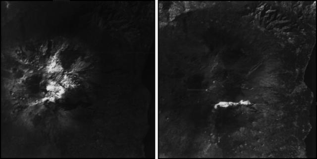
Starting in mid-October, hydroacoustic sensors at Wake Island (2.2 km E) recorded signals consistent with submarine volcanic activity, according to a report from the USGS issued on 15 November 2022. A combined analysis of the hydroacoustic signals and seismic stations located at Guam and Chichijima Island, Japan, suggested that the source of this activity was at or near the Ahyi seamount. After a re-analysis of a satellite image of the area that was captured on 6 November, USGS confirmed that there was no evidence of discoloration at the ocean surface. Few hydroacoustic and seismic signals continued through November, including on 18 November, which USGS suggested signified a decline or pause in unrest. A VONA (Volcano Observatory Notice for Aviation) reported that a discolored water plume was persistently visible in satellite data starting on 18 November (figure 6). Though clouds often obscured clear views of the volcano, another discolored water plume was captured in a satellite image on 26 November. The Aviation Color Code (ACC) was raised to Yellow (the second lowest level on a four-color scale) and the Volcano Alert Level (VAL) was raised to Advisory (the second lowest level on a four-level scale) on 29 November.
During December, occasional detections were recorded on the Wake Island hydrophone sensors and discolored water over the seamount remained visible. During 2-7, 10-12, and 16-31 December possible explosion signals were detected. A small area of discolored water was observed in high-resolution Sentinel-2 satellite images during 1-6 December (figure 7). High-resolution satellite images recorded discolored water plumes on 13 December that originated from the summit region; no observations indicated that activity breached the ocean surface. A possible underwater plume was visible in satellite images on 18 December, and during 19-20 December a definite but diffuse underwater plume located SSE from the main vent was reported. An underwater plume was visible in a satellite image taken on 26 December (figure 7).
Hydrophone sensors continued to detect signals consistent with possible explosions during 1-8 January 2023. USGS reported that the number of detections decreased during 4-5 January. The hydrophone sensors experienced a data outage that started at 0118 on 8 January and continued through 10 January, though according to USGS, possible explosions were recorded prior to the data outage and likely continued during the outage. A discolored water plume originating from the summit region was detected in a partly cloudy satellite image on 8 January. On 11-12 and 15-17 January possible explosion signals were recorded again. One small signal was detected during 22-23 January and several signals were recorded on 25 and 31 January. During 27-31 January a plume of discolored water was observed above the seamount in satellite imagery (figure 8).
Low levels of activity continued during February and March, based on data from pressure sensors on Wake Island. During 1 and 4-6 February activity was reported, and a submarine plume was observed on 4 February (figure 8). Possible explosion signals were detected during 7-8, 10, 13-14, and 24 February. During 1-2 and 3-5 March a plume of discolored water was observed in satellite imagery (figure 8). Almost continuous hydroacoustic signals were detected in remote pressure sensor data on Wake Island 2,270 km E from the volcano during 7-13 March. During 12-13 March water discoloration around the seamount was observed in satellite imagery, despite cloudy weather. By 14 March discolored water extended about 35 km, but no direction was noted. USGS reported that the continuous hydroacoustic signals detected during 13-14 March stopped abruptly on 14 March and no new detections were observed. Three 30 second hydroacoustic detections were reported during 17-19 March, but no activity was visible due to cloudy weather. A data outage was reported during 21-22 March, making pressure sensor data unavailable; a discolored water plume was, however, visible in satellite data. A possible underwater explosion signal was detected by pressure sensors at Wake Island on 26, 29, and 31 March, though the cause and origin of these events were unclear.
Similar low activity continued during April, May, and June. Several signals were detected during 1-3 April in pressure sensors at Wake Island. USGS suggested that these may be related to underwater explosions or earthquakes at the volcano, but no underwater plumes were visible in clear satellite images. The pressure sensors had data outages during 12-13 April and no data were recorded; no underwater plumes were visible in satellite images, although cloudy weather obscured most clear views. Eruptive activity was reported starting at 2210 on 21 May. On 22 May a discolored water plume that extended 4 km was visible in satellite images, though no direction was recorded. During 23-24 May some signals were detected by the underwater pressure sensors. Possible hydroacoustic signals were detected during 2-3 and 6-8 June. Multiple hydroacoustic signals were detected during 9-11 and 16-17 June, although no activity was visible in satellite images. One hydroacoustic signal was detected during 23-24 June, but there was some uncertainty about its association with volcanic activity. A single possible hydroacoustic signal was detected during 30 June to 1 July.
Geologic Background. Ahyi seamount is a large conical submarine volcano that rises to within 75 m of the ocean surface ~18 km SE of the island of Farallon de Pajaros in the northern Marianas. Water discoloration has been observed there, and in 1979 the crew of a fishing boat felt shocks over the summit area, followed by upwelling of sulfur-bearing water. On 24-25 April 2001 an explosive eruption was detected seismically by a station on Rangiroa Atoll, Tuamotu Archipelago. The event was well constrained (+/- 15 km) at a location near the southern base of Ahyi. An eruption in April-May 2014 was detected by NOAA divers, hydroacoustic sensors, and seismic stations.
Information Contacts: US Geological Survey, Volcano Hazards Program (USGS-VHP), 12201 Sunrise Valley Drive, Reston, VA, USA, https://volcanoes.usgs.gov/index.html; Copernicus Browser, Copernicus Data Space Ecosystem, European Space Agency (URL: https://dataspace.copernicus.eu/browser/).
Kadovar (Papua New Guinea) — June 2023 Cite this Report
Kadovar
Papua New Guinea
3.608°S, 144.588°E; summit elev. 365 m
All times are local (unless otherwise noted)
An ash plume and weak thermal anomaly during May 2023
Kadovar is a 2-km-wide island that is the emergent summit of a Bismarck Sea stratovolcano. It lies off the coast of New Guinea, about 25 km N of the mouth of the Sepik River. Prior to an eruption that began in 2018, a lava dome formed the high point of the volcano, filling an arcuate landslide scarp open to the S. Submarine debris-avalanche deposits occur to the S of the island. The current eruption began in January 2018 and has comprised lava effusion from vents at the summit and at the E coast; more recent activity has consisted of ash plumes, weak thermal activity, and gas-and-steam plumes (BGVN 48:02). This report covers activity during February through May 2023 using information from the Darwin Volcanic Ash Advisory Center (VAAC) and satellite data.
Activity during the reporting period was relatively low and mainly consisted of white gas-and-steam plumes that were visible in natural color satellite images on clear weather days (figure 67). According to a Darwin VAAC report, at 2040 on 6 May an ash plume rose to 4.6 km altitude and drifted W; by 2300 the plume had dissipated. MODIS satellite instruments using the MODVOLC thermal algorithm detected a single thermal hotspot on the SE side of the island on 7 May. Weak thermal activity was also detected in a satellite image on the E side of the island on 14 May, accompanied by a white gas-and-steam plume that drifted SE (figure 68).
Geologic Background. The 2-km-wide island of Kadovar is the emergent summit of a Bismarck Sea stratovolcano of Holocene age. It is part of the Schouten Islands, and lies off the coast of New Guinea, about 25 km N of the mouth of the Sepik River. Prior to an eruption that began in 2018, a lava dome formed the high point of the andesitic volcano, filling an arcuate landslide scarp open to the south; submarine debris-avalanche deposits occur in that direction. Thick lava flows with columnar jointing forms low cliffs along the coast. The youthful island lacks fringing or offshore reefs. A period of heightened thermal phenomena took place in 1976. An eruption began in January 2018 that included lava effusion from vents at the summit and at the E coast.
Information Contacts: Darwin Volcanic Ash Advisory Centre (VAAC), Bureau of Meteorology, Northern Territory Regional Office, PO Box 40050, Casuarina, NT 0811, Australia (URL: http://www.bom.gov.au/info/vaac/); Hawai'i Institute of Geophysics and Planetology (HIGP) - MODVOLC Thermal Alerts System, School of Ocean and Earth Science and Technology (SOEST), Univ. of Hawai'i, 2525 Correa Road, Honolulu, HI 96822, USA (URL: http://modis.higp.hawaii.edu/); Copernicus Browser, Copernicus Data Space Ecosystem, European Space Agency (URL: https://dataspace.copernicus.eu/browser/).
San Miguel (El Salvador) — June 2023 Cite this Report
San Miguel
El Salvador
13.434°N, 88.269°W; summit elev. 2130 m
All times are local (unless otherwise noted)
Small gas-and-ash explosions during March and May 2023
San Miguel in El Salvador is a broad, deep crater complex that has been frequently modified by eruptions recorded since the early 16th century and consists of the summit known locally as Chaparrastique. Flank eruptions have produced lava flows that extended to the N, NE, and SE during the 17-19th centuries. The most recent activity has consisted of minor ash eruptions from the summit crater. The current eruption period began in November 2022 and has been characterized by frequent phreatic explosions, gas-and-ash emissions, and sulfur dioxide plumes (BGVN 47:12). This report describes small gas-and-ash explosions during December 2022 through May 2023 based on special reports from the Ministero de Medio Ambiente y Recursos Naturales (MARN).
Activity has been relatively low since the last recorded explosions on 29 November 2022. Seismicity recorded by the San Miguel Volcano Station (VSM) located on the N flank at 1.7 km elevation had decreased by 7 December. Sulfur dioxide gas measurements taken with DOAS (Differential Optical Absorption Spectroscopy) mobile equipment were below typical previously recorded values: 300 tons per day (t/d). During December, small explosions were recorded by the seismic network and manifested as gas-and-steam emissions.
Gas-and-ash explosions in the crater occurred during January 2023, which were recorded by the seismic network. Sulfur dioxide values remained low, between 300-400 t/d through 10 March. At 0817 on 14 January a gas-and-ash emission was visible in webcam images, rising just above the crater rim. Some mornings during February, small gas-and-steam plumes were visible in the crater. On 7 March at 2252 MARN noted an increase in degassing from the central crater; gas emissions were constantly observed through the early morning hours on 8 March. During the early morning of 8 March through the afternoon on 9 March, 12 emissions were registered, some accompanied by ash. The last gas-and-ash emission was recorded at 1210 on 9 March; very fine ashfall was reported in El Tránsito (10 km S), La Morita (6 km W), and La Piedrita (3 km W). The smell of sulfur was reported in Piedra Azul (5 km SW). On 16 March MARN reported that gas-and-steam emissions decreased.
Low degassing and very low seismicity were reported during April; no explosions have been detected between 9 March and 27 May. The sulfur dioxide emissions remained between 350-400 t/d; during 13-20 April sulfur dioxide values fluctuated between 30-300 t/d. Activity remained low through most of May; on 23 May seismicity increased. An explosion was detected at 1647 on 27 May generated a gas-and-ash plume that rose 700 m high (figure 32); a decrease in seismicity and gas emissions followed. The DOAS station installed on the W flank recorded sulfur dioxide values that reached 400 t/d on 27 May; subsequent measurements showed a decrease to 268 t/d on 28 May and 100 t/d on 29 May.
Geologic Background. The symmetrical cone of San Miguel, one of the most active volcanoes in El Salvador, rises from near sea level to form one of the country's most prominent landmarks. A broad, deep, crater complex that has been frequently modified by eruptions recorded since the early 16th century caps the truncated unvegetated summit, also known locally as Chaparrastique. Flanks eruptions of the basaltic-andesitic volcano have produced many lava flows, including several during the 17th-19th centuries that extended to the N, NE, and SE. The SE-flank flows are the largest and form broad, sparsely vegetated lava fields crossed by highways and a railroad skirting the base of the volcano. Flank vent locations have migrated higher on the edifice during historical time, and the most recent activity has consisted of minor ash eruptions from the summit crater.
Information Contacts: Ministero de Medio Ambiente y Recursos Naturales (MARN), Km. 5½ Carretera a Nueva San Salvador, Avenida las Mercedes, San Salvador, El Salvador (URL: http://www.snet.gob.sv/ver/vulcanologia).
Semisopochnoi (United States) — June 2023 Cite this Report
Semisopochnoi
United States
51.93°N, 179.58°E; summit elev. 1221 m
All times are local (unless otherwise noted)
Occasional explosions, ash deposits, and gas-and-steam plumes during December 2022-May 2023
Semisopochnoi is located in the western Aleutians, is 20-km-wide at sea level, and contains an 8-km-wide caldera. The three-peaked Mount Young (formerly Cerberus) was constructed within the caldera during the Holocene. Each of these peaks contains a summit crater; the lava flows on the N flank appear younger than those on the S side. The current eruption period began in early February 2021 and has more recently consisted of intermittent explosions and ash emissions (BGVN 47:12). This report updates activity during December 2022 through May 2023 using daily, weekly, and special reports from the Alaska Volcano Observatory (AVO). AVO monitors the volcano using local seismic and infrasound sensors, satellite data, web cameras, and remote infrasound and lightning networks.
Activity during most of December 2022 was relatively quiet; according to AVO no eruptive or explosive activity was observed since 7 November 2022. Intermittent tremor and occasional small earthquakes were observed in geophysical data. Continuous gas-and-steam emissions were observed from the N crater of Mount Young in webcam images on clear weather days (figure 25). On 24 December, there was a slight increase in earthquake activity and several small possible explosion signals were detected in infrasound data. Eruptive activity resumed on 27 December at the N crater of Mount Young; AVO issued a Volcano Activity Notice (VAN) that reported minor ash deposits on the flanks of Mount Young that extended as far as 1 km from the vent, according to webcam images taken during 27-28 December (figure 26). No ash plumes were observed in webcam or satellite imagery, but a persistent gas-and-steam plume that might have contained some ash rose to 1.5 km altitude. As a result, AVO raised the Aviation Color Code (ACC) to Orange (the second highest level on a four-color scale) and the Volcano Alert Level (VAL) to Watch (the second highest level on a four-level scale). Possible explosions were detected during 21 December 2022 through 1 January 2023 and seismic tremor was recorded during 30-31 December.
During January 2023 eruptive activity continued at the active N crater of Mount Young. Minor ash deposits were observed on the flanks, extending about 2 km SSW, based on webcam images from 1 and 3 January. A possible explosion occurred during 1-2 January based on elevated seismicity recorded on local seismometers and an infrasound signal recorded minutes later by an array at Adak. Though no ash plumes were observed in webcam or satellite imagery, a persistent gas-and-steam plume rose to 1.5 km altitude that might have carried minor traces of ash. Ash deposits were accompanied by periods of elevated seismicity and infrasound signals from the local geophysical network, which AVO reported were likely due to weak explosive activity. Low-level explosive activity was also detected during 2-3 January, with minor gas-and-steam emissions and a new ash deposit that was visible in webcam images. Low-level explosive activity was detected in geophysical data during 4-5 January, with elevated seismicity and infrasound signals observed on local stations. Volcanic tremor was detected during 7-9 January and very weak explosive activity was detected in seismic and infrasound data on 9 January. Weak seismic and infrasound signals were recorded on 17 January, which indicated minor explosive activity, but no ash emissions were observed in clear webcam images; a gas-and-steam plume continued to rise to 1.5 km altitude. During 29-30 January, ash deposits near the summit were observed on fresh snow, according to webcam images.
The active N cone at Mount Young continued to produce a gas-and-steam plume during February, but no ash emissions or explosive events were detected. Seismicity remained elevated with faint tremor during early February. Gas-and-steam emissions from the N crater were observed in clear webcam images on 11-13 and 16 February; no explosive activity was detected in seismic, infrasound, or satellite data. Seismicity has also decreased, with no significant seismic tremor observed since 25 January. Therefore, the ACC was lowered to Yellow (the second lowest level on a four-color scale) and the VAL was lowered to Advisory (the second lowest level on a four-color scale) on 22 February.
Gas-and-steam emissions persisted during March from the N cone of Mount Young, based on clear webcam images. A few brief episodes of weak tremor were detected in seismic data, although seismicity decreased over the month. A gas-and-steam plume detected in satellite data extended 150 km on 18 March. Low-level ash emissions from the N cone at Mount Young were observed in several webcam images during 18-19 March, in addition to small explosions and volcanic tremor. The ACC was raised to Orange and the VAL increased to Watch on 19 March. A small explosion was detected in seismic and infrasound data on 21 March.
Low-level unrest continued during April, although cloudy weather often obscured views of the summit; periods of seismic tremor and local earthquakes were recorded. During 3-4 April a gas-and-steam plume was visible traveling more than 200 km overnight; no ash was evident in the plume, according to AVO. A gas-and-steam plume was observed during 4-6 April that extended 400 km but did not seem to contain ash. Small explosions were detected in seismic and infrasound data on 5 April. Occasional clear webcam images showed continuing gas-and-steam emissions rose from Mount Young, but no ash deposits were observed on the snow. On 19 April small explosions and tremor were detected in seismic and infrasound data. A period of seismic tremor was detected during 22-25 April, with possible weak explosions on 25 April. Ash deposits were visible near the crater rim, but it was unclear if these deposits were recent or due to older deposits.
Occasional small earthquakes were recorded during May, but there were no signs of explosive activity seen in geophysical data. Gas-and-steam emissions continued from the N crater of Mount Young, based on webcam images, and seismicity remained slightly elevated. A new, light ash deposit was visible during the morning of 5 May on fresh snow on the NW flank of Mount Young. During 10 May periods of volcanic tremor were observed. The ACC was lowered to Yellow and the VAL to Advisory on 17 May due to no additional evidence of activity.
Geologic Background. Semisopochnoi, the largest subaerial volcano of the western Aleutians, is 20 km wide at sea level and contains an 8-km-wide caldera. It formed as a result of collapse of a low-angle, dominantly basaltic volcano following the eruption of a large volume of dacitic pumice. The high point of the island is Anvil Peak, a double-peaked late-Pleistocene cone that forms much of the island's northern part. The three-peaked Mount Cerberus (renamed Mount Young in 2023) was constructed within the caldera during the Holocene. Each of the peaks contains a summit crater; lava flows on the N flank appear younger than those on the south side. Other post-caldera volcanoes include the symmetrical Sugarloaf Peak SSE of the caldera and Lakeshore Cone, a small cinder cone at the edge of Fenner Lake in the NE part of the caldera. Most documented eruptions have originated from Young, although Coats (1950) considered that both Sugarloaf and Lakeshore Cone could have been recently active.
Information Contacts: Alaska Volcano Observatory (AVO), a cooperative program of a) U.S. Geological Survey, 4200 University Drive, Anchorage, AK 99508-4667 USA (URL: https://avo.alaska.edu/), b) Geophysical Institute, University of Alaska, PO Box 757320, Fairbanks, AK 99775-7320, USA, and c) Alaska Division of Geological & Geophysical Surveys, 794 University Ave., Suite 200, Fairbanks, AK 99709, USA (URL: http://dggs.alaska.gov/).
Ebeko
Russia
50.686°N, 156.014°E; summit elev. 1103 m
All times are local (unless otherwise noted)
Continued explosions, ash plumes, and ashfall during October 2022-May 2023
Ebeko, located on the N end of Paramushir Island in the Kuril Islands, consists of three summit craters along a SSW-NNE line at the northern end of a complex of five volcanic cones. Eruptions date back to the late 18th century and have been characterized as small-to-moderate explosions from the summit crater, accompanied by intense fumarolic activity. The current eruption period began in June 2022 and has recently consisted of frequent explosions, ash plumes, and thermal activity (BGVN 47:10). This report covers similar activity during October 2022 through May 2023, based on information from the Kamchatka Volcanic Eruptions Response Team (KVERT) and satellite data.
Activity during October consisted of explosive activity, ash plumes, and occasional thermal anomalies. Visual data by volcanologists from Severo-Kurilsk showed explosions producing ash clouds up to 2.1-3 km altitude which drifted E, N, NE, and SE during 1-8, 10, 16, and 18 October. KVERT issued several Volcano Observatory Notices for Aviation (VONA) on 7, 13-15, and 27 October 2022, stating that explosions generated ash plumes that rose to 2.3-4 km altitude and drifted 5 km E, NE, and SE. Ashfall was reported in Severo-Kurilsk (Paramushir Island, about 7 km E) on 7 and 13 October. Satellite data showed a thermal anomaly over the volcano on 15-16 October. Visual data showed ash plumes rising to 2.5-3.6 km altitude on 22, 25-29, and 31 October and moving NE due to constant explosions.
Similar activity continued during November, with explosions, ash plumes, and ashfall occurring. KVERT issued VONAs on 1-2, 4, 6-7, 9, 13, and 16 November that reported explosions and resulting ash plumes that rose to 1.7-3.6 km altitude and drifted 3-5 km SE, ESE, E, and NE. On 1 November ash plumes extended as far as 110 km SE. On 5, 8, 12, and 24-25 November explosions and ash plumes rose to 2-3.1 km altitude and drifted N and E. Ashfall was observed in Severo-Kurilsk on 7 and 16 November. A thermal anomaly was visible during 1-4, 16, and 20 November. Explosions during 26 November rose as high as 2.7 km altitude and drifted NE (figure 45).
Explosions and ash plumes continued to occur in December. During 1-2 and 4 December volcanologists from Severo-Kurilsk observed explosions that sent ash to 1.9-2.5 km altitude and drifted NE and SE (figure 46). VONAs were issued on 5, 9, and 16 December reporting that explosions generated ash plumes rising to 1.9 km, 2.6 km, and 2.4 km altitude and drifted 5 km SE, E, and NE, respectively. A thermal anomaly was visible in satellite imagery on 16 December. On 18 and 27-28 December explosions produced ash plumes that rose to 2.5 km altitude and drifted NE and SE. On 31 December an ash plume rose to 2 km altitude and drifted NE.
Explosions continued during January 2023, based on visual observations by volcanologists from Severo-Kurilsk. During 1-7 January explosions generated ash plumes that rose to 4 km altitude and drifted NE, E, W, and SE. According to VONAs issued by KVERT on 2, 4, 10, and 23 January, explosions produced ash plumes that rose to 2-4 km altitude and drifted 5 km N, NE, E, and ENE; the ash plume that rose to 4 km altitude occurred on 10 January (figure 47). Satellite data showed a thermal anomaly during 3-4, 10, 13, 16, 21, 22, and 31 January. KVERT reported that an ash cloud on 4 January moved 12 km NE. On 6 and 9-11 January explosions sent ash plumes to 4.5 km altitude and drifted W and ESE. On 13 January an ash plume rose to 3 km altitude and drifted SE. During 20-24 January ash plumes from explosions rose to 3.7 km altitude and drifted SE, N, and NE. On 21 January the ash plume drifted as far as 40 km NE. During 28-29 and 31 January and 1 February ash plumes rose to 4 km altitude and drifted NE.
During February, explosions, ash plumes, and ashfall were reported. During 1, 4-5 and 7-8 February explosions generated ash plumes that rose to 4.5 km altitude and drifted E and NE; ashfall was observed on 5 and 8 February. On 6 February an explosion produced an ash plume that rose to 3 km altitude and drifted 7 km E, causing ashfall in Severo-Kurilsk. A thermal anomaly was visible in satellite data on 8, 9, 13, and 21 February. Explosions on 9 and 12-13 February produced ash plumes that rose to 4 km altitude and drifted E and NE; the ash cloud on 12 February extended as far as 45 km E. On 22 February explosions sent ash to 3 km altitude that drifted E. During 24 and 26-27 February ash plumes rose to 4 km altitude and drifted E. On 28 February an explosion sent ash to 2.5-3 km altitude and drifted 5 km E; ashfall was observed in Severo-Kurilsk.
Activity continued during March; visual observations showed that explosions generated ash plumes that rose to 3.6 km altitude on 3, 5-7, and 9-12 March and drifted E, NE, and NW. Thermal anomalies were visible on 10, 13, and 29-30 March in satellite imagery. On 18, 21-23, 26, and 29-30 March explosions produced ash plumes that rose to 2.8 km altitude and drifted NE and E; the ash plumes during 22-23 March extended up to 76 km E. A VONA issued on 21 March reported an explosion that produced an ash plume that rose to 2.8 km altitude and drifted 5 km E. Another VONA issued on 23 March reported that satellite data showed an ash plume rising to 3 km altitude and drifted 14 km E.
Explosions during April continued to generate ash plumes. On 1 and 4 April an ash plume rose to 2.8-3.5 km altitude and drifted SE and NE. A thermal anomaly was visible in satellite imagery during 1-6 April. Satellite data showed ash plumes and clouds rising to 2-3 km altitude and drifting up to 12 km SW and E on 3 and 6 April (figure 48). KVERT issued VONAs on 3, 5, 14, 16 April describing explosions that produced ash plumes rising to 3 km, 3.5 km, 3.5 km, and 3 km altitude and drifting 5 km S, 5 km NE and SE, 72 km NNE, and 5 km NE, respectively. According to satellite data, the resulting ash cloud from the explosion on 14 April was 25 x 7 km in size and drifted 72-104 km NNE during 14-15 April. According to visual data by volcanologists from Severo-Kurilsk explosions sent ash up to 3.5 km altitude that drifted NE and E during 15-16, 22, 25-26, and 29 April.
The explosive eruption continued during May. Explosions during 3-4, 6-7, and 9-10 May generated ash plumes that rose to 4 km altitude and drifted SW and E. Satellite data showed a thermal anomaly on 3, 9, 13-14, and 24 May. During 12-16, 23-25, and 27-28 May ash plumes rose to 3.5 km altitude and drifted in different directions due to explosions. Two VONA notices were issued on 16 and 25 May, describing explosions that generated ash plumes rising to 3 km and 3.5 km altitude, respectively and extending 5 km E. The ash cloud on 25 May drifted 75 km SE.
Thermal activity in the summit crater, occasionally accompanied by ash plumes and ash deposits on the SE and E flanks due to frequent explosions, were visible in infrared and true color satellite images (figure 49).
Geologic Background. The flat-topped summit of the central cone of Ebeko volcano, one of the most active in the Kuril Islands, occupies the northern end of Paramushir Island. Three summit craters located along a SSW-NNE line form Ebeko volcano proper, at the northern end of a complex of five volcanic cones. Blocky lava flows extend west from Ebeko and SE from the neighboring Nezametnyi cone. The eastern part of the southern crater contains strong solfataras and a large boiling spring. The central crater is filled by a lake about 20 m deep whose shores are lined with steaming solfataras; the northern crater lies across a narrow, low barrier from the central crater and contains a small, cold crescentic lake. Historical activity, recorded since the late-18th century, has been restricted to small-to-moderate explosive eruptions from the summit craters. Intense fumarolic activity occurs in the summit craters, on the outer flanks of the cone, and in lateral explosion craters.
Information Contacts: Kamchatka Volcanic Eruptions Response Team (KVERT), Far Eastern Branch, Russian Academy of Sciences, 9 Piip Blvd., Petropavlovsk-Kamchatsky, 683006, Russia (URL: http://www.kscnet.ru/ivs/kvert/); MIROVA (Middle InfraRed Observation of Volcanic Activity), a collaborative project between the Universities of Turin and Florence (Italy) supported by the Centre for Volcanic Risk of the Italian Civil Protection Department (URL: http://www.mirovaweb.it/); Copernicus Browser, Copernicus Data Space Ecosystem, European Space Agency (URL: https://dataspace.copernicus.eu/browser/).
Home Reef
Tonga
18.992°S, 174.775°W; summit elev. -10 m
All times are local (unless otherwise noted)
Discolored plumes continued during November 2022-April 2023
Home Reef is a submarine volcano located in the central Tonga islands between Lateiki (Metis Shoal) and Late Island. The first recorded eruption occurred in the mid-19th century, when an ephemeral island formed. An eruption in 1984 produced a 12-km-high eruption plume, a large volume of floating pumice, and an ephemeral island 500 x 1,500 m wide, with cliffs 30-50 m high that enclosed a water-filled crater. Another island-forming eruption in 2006 produced widespread pumice rafts that drifted as far as Australia; by 2008 the island had eroded below sea level. The previous eruption occurred during October 2022 and was characterized by a new island-forming eruption, lava effusion, ash plumes, discolored water, and gas-and-steam plumes (BGVN 47:11). This report covers discolored water plumes during November 2022 through April 2023 using satellite data.
Discolored plumes continued during the reporting period and were observed in true color satellite images on clear weather days. Satellite images show light green-yellow discolored water extending W on 8 and 28 November 2022 (figure 31), and SW on 18 November. Light green-yellow plumes extended W on 3 December, S on 13 December, SW on 18 December, and W and S on 23 December (figure 31). On 12 January 2023 discolored green-yellow plumes extended to the NE, E, SE, and N. The plume moved SE on 17 January and NW on 22 January. Faint discolored water in February was visible moving NE on 1 February. A discolored plume extended NW on 8 and 28 March and NW on 13 March (figure 31). During April, clear weather showed green-blue discolored plumes moving S on 2 April, W on 7 April, and NE and S on 12 April. A strong green-yellow discolored plume extended E and NE on 22 April for several kilometers (figure 31).
Geologic Background. Home Reef, a submarine volcano midway between Metis Shoal and Late Island in the central Tonga islands, was first reported active in the mid-19th century, when an ephemeral island formed. An eruption in 1984 produced a 12-km-high eruption plume, large amounts of floating pumice, and an ephemeral 500 x 1,500 m island, with cliffs 30-50 m high that enclosed a water-filled crater. In 2006 an island-forming eruption produced widespread dacitic pumice rafts that drifted as far as Australia. Another island was built during a September-October 2022 eruption.
Information Contacts: Copernicus Browser, Copernicus Data Space Ecosystem, European Space Agency (URL: https://dataspace.copernicus.eu/browser/).
Ambae
Vanuatu
15.389°S, 167.835°E; summit elev. 1496 m
All times are local (unless otherwise noted)
New lava flow, ash plumes, and sulfur dioxide plumes during February-May 2023
Ambae, also known as Aoba, is a large basaltic shield volcano in Vanuatu. A broad pyroclastic cone containing three crater lakes (Manaro Ngoru, Voui, and Manaro Lakua) is located at the summit within the youngest of at least two nested calderas. Periodic phreatic and pyroclastic explosions have been reported since the 16th century. A large eruption more than 400 years ago resulted in a volcanic cone within the summit crater that is now filled by Lake Voui; the similarly sized Lake Manaro fills the western third of the caldera. The previous eruption ended in August 2022 that was characterized by gas-and-steam and ash emissions and explosions of wet tephra (BGVN 47:10). This report covers a new eruption during February through May 2023 that consisted of a new lava flow, ash plumes, and sulfur dioxide emissions, using information from the Vanuatu Meteorology and Geo-Hazards Department (VMGD) and satellite data.
During the reporting period, the Alert Level remained at a 2 (on a scale of 0-5), which has been in place since December 2021. Activity during October 2022 through March 2023 remained relatively low and mostly consisted of gas-and-steam emissions in Lake Voui. VMGD reported that at 1300 on 15 November a satellite image captured a strong amount of sulfur dioxide rising above the volcano (figure 99), and that seismicity slightly increased. The southern and northern part of the island reported a strong sulfur dioxide smell and heard explosions. On 20 February 2023 a gas-and-ash plume rose 1.3 km above the summit and drifted SSW, according to a webcam image (figure 100). Gas-and-steam and possibly ash emissions continued on 23 February and volcanic earthquakes were recorded by the seismic network.
During April, volcanic earthquakes and gas-and-steam and ash emissions were reported from the cone in Lake Voui. VMGD reported that activity increased during 5-7 April; high gas-and-steam and ash plumes were visible, accompanied by nighttime incandescence. According to a Wellington VAAC report, a low-level ash plume rose as high as 2.5 km above the summit and drifted W and SW on 5 April, based on satellite imagery. Reports in Saratamata stated that a dark ash plume drifted to the WSW, but no loud explosion was heard. Webcam images from 2100 showed incandescence above the crater and reflected in the clouds. According to an aerial survey, field observations, and satellite data, water was no longer present in the lake. A lava flow was reported effusing from the vent and traveling N into the dry Lake Voui, which lasted three days. The next morning at 0745 on 6 April a gas-and-steam and ash plume rose 5.4 km above the summit and drifted ESE, based on information from VMGD (figure 101). The Wellington VAAC also reported that light ashfall was observed on the island. Intermittent gas-and-steam and ash emissions were visible on 7 April, some of which rose to an estimated 3 km above the summit and drifted E. Webcam images during 0107-0730 on 7 April showed continuing ash emissions. A gas-and-steam and ash plume rose 695 m above the summit crater at 0730 on 19 April and drifted ESE, based on a webcam image (figure 102).
According to visual and infrared satellite data, water was visible in Lake Voui as late as 24 March 2023 (figure 103). The vent in the caldera showed a gas-and-steam plume drifted SE. On 3 April thermal activity was first detected, accompanied by a gas-and-ash plume that drifted W (figure 103). The lava flow moved N within the dry lake and was shown cooling by 8 April. By 23 April much of the water in the lake had returned. Occasional sulfur dioxide plumes were detected by the TROPOMI instrument on the Sentinel-5P satellite that exceeded 2 Dobson Units (DU) and drifted in different directions (figure 104).
Geologic Background. The island of Ambae, also known as Aoba, is a massive 2,500 km3 basaltic shield that is the most voluminous volcano of the New Hebrides archipelago. A pronounced NE-SW-trending rift zone with numerous scoria cones gives the 16 x 38 km island an elongated form. A broad pyroclastic cone containing three crater lakes (Manaro Ngoru, Voui, and Manaro Lakua) is located at the summit within the youngest of at least two nested calderas, the largest of which is 6 km in diameter. That large central edifice is also called Manaro Voui or Lombenben volcano. Post-caldera explosive eruptions formed the summit craters about 360 years ago. A tuff cone was constructed within Lake Voui (or Vui) about 60 years later. The latest known flank eruption, about 300 years ago, destroyed the population of the Nduindui area near the western coast.
Information Contacts: Geo-Hazards Division, Vanuatu Meteorology and Geo-Hazards Department (VMGD), Ministry of Climate Change Adaptation, Meteorology, Geo-Hazards, Energy, Environment and Disaster Management, Private Mail Bag 9054, Lini Highway, Port Vila, Vanuatu (URL: http://www.vmgd.gov.vu/, https://www.facebook.com/VanuatuGeohazardsObservatory/); Wellington Volcanic Ash Advisory Centre (VAAC), Meteorological Service of New Zealand Ltd (MetService), PO Box 722, Wellington, New Zealand (URL: http://www.metservice.com/vaac/, http://www.ssd.noaa.gov/VAAC/OTH/NZ/messages.html); MIROVA (Middle InfraRed Observation of Volcanic Activity), a collaborative project between the Universities of Turin and Florence (Italy) supported by the Centre for Volcanic Risk of the Italian Civil Protection Department (URL: http://www.mirovaweb.it/); Global Sulfur Dioxide Monitoring Page, Atmospheric Chemistry and Dynamics Laboratory, NASA Goddard Space Flight Center (NASA/GSFC), 8800 Greenbelt Road, Goddard, Maryland, USA (URL: https://so2.gsfc.nasa.gov/); Copernicus Browser, Copernicus Data Space Ecosystem, European Space Agency (URL: https://dataspace.copernicus.eu/browser/).
Search Bulletin Archive by Publication Date
Select a month and year from the drop-downs and click "Show Issue" to have that issue displayed in this tab.
The default month and year is the latest issue available.
Bulletin of the Global Volcanism Network - Volume 17, Number 05 (May 1992)
Managing Editor: Lindsay McClelland
Additional Reports (Unknown)
Fiji: Pumice rafts; source unknown
Aira (Japan)
Explosions and seismic swarms continue
Antuco (Chile)
Fumarolic activity in summit crater's small scoria cone
Arenal (Costa Rica)
Lava flows continue to advance; stronger and more frequent explosions
Asosan (Japan)
Mud/water ejections from heating crater lake; tremor episodes
Avachinsky (Russia)
Fumarolic activity around 1991 dome
Barren Island (India)
Continued gas emission from central crater and lava flow; animal and plant life recovering
Bezymianny (Russia)
Gas emission from center of dome
Etna (Italy)
Fissure eruption continues; lava diverted; lava field described
Fuego (Guatemala)
Seismicity and continued fumarolic activity
Galeras (Colombia)
Occasional explosions eject ash; strong fumarolic activity on 1991 dome; earthquakes and tremor decline
Heard (Australia)
Plumes and glow; volcano morphology and 1986-87 activity described; 1992 summit eruption
Ijen (Indonesia)
Infrared Space Shuttle photograph shows caldera and crater lake
Irazu (Costa Rica)
Fumarolic activity in and around crater lake; low-frequency seismicity
Kanlaon (Philippines)
Small ash emission
Kilauea (United States)
Lava production from episode-51 vent interrupted by brief pauses; lava lake in nearby crater
Klyuchevskoy (Russia)
Small explosions eject ash
Kozushima (Japan)
Continued seismic swarms
Langila (Papua New Guinea)
Moderate explosive activity from 2 craters
Lascar (Chile)
New dome fills base of crater; occasional explosions
Manam (Papua New Guinea)
Strong explosions from summit craters; lava flows; avalanches
Pacaya (Guatemala)
Numerous explosions; lava flows; temporary evacuations
Pinatubo (Philippines)
Rains on 1991 deposits produce destructive mudflows
Poas (Costa Rica)
Thermal activity in crater lake feeds 1-km plume; frequent earthquakes and occasional tremor
Rabaul (Papua New Guinea)
Seismic swarm; uplift over broad area
Raung (Indonesia)
Infrared Space Shuttle photograph shows devegetated summit area
Rincon de la Vieja (Costa Rica)
Thermal activity from crater lake; occasional seismicity
Rinjani (Indonesia)
Infrared Space Shuttle photo of Lombok Island during May 1992
Ruapehu (New Zealand)
Thermal activity but no phreatic eruptions from Crater Lake
Saba (Netherlands)
Seismic swarm
Santa Maria (Guatemala)
Frequent explosions feed small ash columns; continued erosion threatens vent area
Spurr (United States)
Ash eruption follows increased seismicity and thermal activity
Stromboli (Italy)
Frequent explosions; increased seismicity
Suwanosejima (Japan)
Tephra clouds from frequent explosions
Tongariro (New Zealand)
Fumarole temperatures and gas chemistry unchanged from 1989; no significant deformation or seismicity
Unzendake (Japan)
Lava-dome growth and pyroclastic flows
Villarrica (Chile)
Volcanic earthquakes and tremor
Whakaari/White Island (New Zealand)
Continued tephra ejection from three vents
Additional Reports (Unknown) — May 1992 Cite this Report
Additional Reports
Unknown
Unknown, Unknown; summit elev. m
All times are local (unless otherwise noted)
Fiji: Pumice rafts; source unknown
A Fiji Air passenger saw two narrow, elongate rafts of drifting pumice in the Kadavu passage ~30 km SE of Suva (figure 1) on 24 January. Fiji's Maritime Surveillance Centre issued a warning to mariners, published in newspapers on 27 January. Pumice was subsequently reported from ships roughly 50 km SW and 160 km NW of the initial observation.
A search of the Suva Harbour area on 27 January revealed pumice floating in the Suva Passage and stranded at the high-tide line around the Suva Peninsula. The pumice was gravel-sized, with the largest fragment ~4 cm across. The samples were weathered and some included living barnacles up to 9 mm long. After the 1984 Home Reef (Tonga) eruption, barnacles 1.5 cm long were found on pumice that was at most 25 weeks old, so a provisional maximum age of 15 weeks was assigned by Baleivanualala to the barnacles found in January 1992. Given an estimated drift rate of ~12 km/day (Rodda and Jones, 1990), the pumice might have traveled 1,300 km from the eruption site. No reports of eruptions in the Tonga-Kermadec region have been received.
References. Baleivanualala, V., 1992, Drift pumice in Kadavu Passage, January 1992: Fiji Mineral Resources Department Note BP57/1, 3 pp.
Rodda, P., and Jones, T.D., 1990, The 1990 reports of drift pumice in Fiji (Corrigendum): Fiji Mineral Resources Department Note BP1/91.
Geologic Background. Reports of floating pumice from an unknown source, hydroacoustic signals, or possible eruption plumes seen in satellite imagery.
Information Contacts: V. Baleivanualala and P. Rodda, Mineral Resources Dept, Suva, Fiji.
Aira
Japan
31.5772°N, 130.6589°E; summit elev. 1117 m
All times are local (unless otherwise noted)
Explosions and seismic swarms continue
Eight explosions occurred . . . in May . . . . The month's highest ash plume rose 2,500 m on 22 May. Seismic swarms were recorded seven times in May, each lasting for ~5 hours, normal for the volcano.
Geologic Background. The Aira caldera in the northern half of Kagoshima Bay contains the post-caldera Sakurajima volcano, one of Japan's most active. Eruption of the voluminous Ito pyroclastic flow accompanied formation of the 17 x 23 km caldera about 22,000 years ago. The smaller Wakamiko caldera was formed during the early Holocene in the NE corner of the caldera, along with several post-caldera cones. The construction of Sakurajima began about 13,000 years ago on the southern rim and built an island that was joined to the Osumi Peninsula during the major explosive and effusive eruption of 1914. Activity at the Kitadake summit cone ended about 4,850 years ago, after which eruptions took place at Minamidake. Frequent eruptions since the 8th century have deposited ash on the city of Kagoshima, located across Kagoshima Bay only 8 km from the summit. The largest recorded eruption took place during 1471-76.
Information Contacts: JMA.
Antuco
Chile
37.406°S, 71.349°W; summit elev. 2979 m
All times are local (unless otherwise noted)
Fumarolic activity in summit crater's small scoria cone
During a February overflight, fumarolic activity was visible in the small scoria cone nested within the main crater. Weak summit fumaroles had previously been observed during visits in 1969, 1982, and March 1984. Fumarolic activity has apparently been continuous, but of variable intensity, from the cone since the volcano's last eruption in 1869. Lava flows from Antuco dammed Laja Lake's outlet in 1853, causing the water level to rise around 20 m.
Geologic Background. Antuco volcano, constructed NE of the Pleistocene Sierra Velluda stratovolcano, rises dramatically above the SW shore of Laguna de la Laja. It has a complicated history beginning with construction of the basaltic-to-andesitic Sierra Velluda and Cerro Condor stratovolcanoes of Pliocene-Pleistocene age. Construction of the Antuco I volcano was followed by edifice failure at the beginning of the Holocene that produced a large debris avalanche which traveled down the Río Laja to the west and left a large 5-km-wide caldera breached to the west. The steep-sided modern basaltic-to-andesitic cone has grown 1,000 m since then; flank fissures and cones have also been active. Moderate explosive eruptions were recorded in the 18th and 19th centuries from both summit and flank vents, and lava flows have traveled into the Río Laja drainage.
Information Contacts: H. Moreno, SAVO, Temuco.
Arenal
Costa Rica
10.463°N, 84.703°W; summit elev. 1670 m
All times are local (unless otherwise noted)
Lava flows continue to advance; stronger and more frequent explosions
Two lobes of the lava flow active since November continued to extend down the W flank in May, with an estimated total volume of 3 x 10⁶ m3 of lava. The northernmost lobe divided into several fronts; the longest reached to ~800 m elevation, while the most active front became channeled in a valley at ~855 m elevation on 14 May. A lava temperature of 820°C was measured at the front using an infrared thermometer. The southern lobe continued to travel along a more gentle slope to ~700 m elevation, covering and burning roughly 100 m2 of forest and grasslands. Summit incandescence, visible at night, suggested to scientists that a lava lake was feeding the active lava flow. Small pyroclastic flows occurred sporadically. One observed at 0723 on 13 May flowed down the W flank to 1,200 m elevation.
Explosive activity increased in number and magnitude from preceding months, especially since 26 May, when new explosions produced ash columns >1 km high and bombs fell to 1,000 m elevation. Between 23 April and 12 May, 80 g/m2 ash had accumulated 1.8 km W of the crater (at 740 m elevation). Samples were composed of very fine ash (40%), and fine and medium-sized scoria fragments and plagioclase crystals (60%). Volcanic earthquakes averaged 10/day in May (compared to 6 and 15 daily in April and March, respectively), with maxima of 20-24 on 15, 23, and 28 May. The month's highest levels of tremor were recorded on 7, 12, 14, 17, and 22 May.
Geologic Background. Conical Volcán Arenal is the youngest stratovolcano in Costa Rica and one of its most active. The 1670-m-high andesitic volcano towers above the eastern shores of Lake Arenal, which has been enlarged by a hydroelectric project. Arenal lies along a volcanic chain that has migrated to the NW from the late-Pleistocene Los Perdidos lava domes through the Pleistocene-to-Holocene Chato volcano, which contains a 500-m-wide, lake-filled summit crater. The earliest known eruptions of Arenal took place about 7000 years ago, and it was active concurrently with Cerro Chato until the activity of Chato ended about 3500 years ago. Growth of Arenal has been characterized by periodic major explosive eruptions at several-hundred-year intervals and periods of lava effusion that armor the cone. An eruptive period that began with a major explosive eruption in 1968 ended in December 2010; continuous explosive activity accompanied by slow lava effusion and the occasional emission of pyroclastic flows characterized the eruption from vents at the summit and on the upper western flank.
Information Contacts: G. Soto, R. Barquero, and G. Alvarado, ICE; M. Fernández, Univ de Costa Rica; E. Fernández, J. Barquero, and V. Barboza, OVSICORI.
Asosan
Japan
32.8849°N, 131.085°E; summit elev. 1592 m
All times are local (unless otherwise noted)
Mud/water ejections from heating crater lake; tremor episodes
Isolated volcanic tremor episodes began to increase in October 1991, reaching about 100 events/day by the end of May. The increase in seismic activity followed a period of quiet after the July 1989-December 1990 eruptive phase. Ejections of mud and water, the first since June 1991, were observed within the active crater lake . . . on 23 April. Similar ejections, to 5 m height, were observed on 27 April, 1 and 27 May, and 2 June. The lake's surface temperature has been increasing since March-May 1991 when it was 20-30°C, reaching ~70°C (measured by infrared thermometer) in May. Weak mud ejections have been common in the past, during the period between eruptive phases when the crater is normally occupied by a lake, but have not been observed during the lowest levels of activity.
Geologic Background. The 24-km-wide Asosan caldera was formed during four major explosive eruptions from 300,000 to 90,000 years ago. These produced voluminous pyroclastic flows that covered much of Kyushu. The last of these, the Aso-4 eruption, produced more than 600 km3 of airfall tephra and pyroclastic-flow deposits. A group of 17 central cones was constructed in the middle of the caldera, one of which, Nakadake, is one of Japan's most active volcanoes. It was the location of Japan's first documented historical eruption in 553 CE. The Nakadake complex has remained active throughout the Holocene. Several other cones have been active during the Holocene, including the Kometsuka scoria cone as recently as about 210 CE. Historical eruptions have largely consisted of basaltic to basaltic-andesite ash emission with periodic strombolian and phreatomagmatic activity. The summit crater of Nakadake is accessible by toll road and cable car, and is one of Kyushu's most popular tourist destinations.
Information Contacts: JMA.
Avachinsky
Russia
53.256°N, 158.836°E; summit elev. 2717 m
All times are local (unless otherwise noted)
Fumarolic activity around 1991 dome
Fumarolic activity was occurring from numerous points around the margins of the January 1991 lava dome during a 13 May overflight. Numerous circumferential and radial fissures, previously observed in October 1991, covered the dome's surface, but the small lava flows that extended down the SSE and SW flanks were no longer visible.
Geologic Background. Avachinsky, one of Kamchatka's most active volcanoes, rises above Petropavlovsk, Kamchatka's largest city. It began to form during the middle or late Pleistocene, and is flanked to the SE by Kozelsky volcano, which has a large crater breached to the NE. A large collapse scarp open to the SW was created when a major debris avalanche about 30,000-40,000 years ago buried an area of about 500 km2 to the south, underlying the city of Petropavlovsk. Reconstruction of the volcano took place in two stages, the first of which began about 18,000 years before present (BP), and the second 7,000 years BP. Most eruptions have been explosive, with pyroclastic flows and hot lahars being directed primarily to the SW by the collapse scarp, although there have also been relatively short lava flows. The frequent historical eruptions have been similar in style and magnitude to previous Holocene eruptions.
Information Contacts: H. Gaudru, SVE, Switzerland; G. de St. Cyr, T. de St. Cyr, and I. de St. Cyr, Lyon, France; T. Vaudelin, Genève, Switzerland.
Barren Island (India) — May 1992 Cite this Report
Barren Island
India
12.278°N, 93.858°E; summit elev. 354 m
All times are local (unless otherwise noted)
Continued gas emission from central crater and lava flow; animal and plant life recovering
A multidisciplinary team from the GSI, IMD, CARI, and the Wildlife Dept visited Barren Island on 21-22 May. Hot gas was emerging from the funnel-shaped [300-m-deep] crater, which had an estimated diameter of [400 m] at the rim. The 1991 lava flow that extended to the coast was covered with rain-compacted scoriae and ash, and had a smooth, flat surface like a paved road. The flow's surface temperature was 40°C, but at 1/3 m depth it exceeded the thermometer's 360°C limit. Gases were emitted from small holes in the flow. A portable seismograph recorded several mild seismic events.
Some burnt ficus trees on the NW coast were sprouting new shoots, but badly charred ones appeared dead. Crabs were plentiful, even on the lava flow, and 25 feral goats were counted in one hour in the surrounding hills. Many birds were visible, but rats were completely absent. The water around the island was clear and of normal temperature, and fish were observed.
Further References. Haldar, D., Laskar, T., Bandyapadhyay, P.C., Sarkar, N.K., and Biswas, J.K., 1992, Volcanic eruption of the Barren Island volcano, Andaman Sea: J. of the Geological Society of India, v. 39, no. 5, p. 411-419.
Haldar, D., Laskar, T., Bandyapadhyay, P.C., Sarkar, N.K., and Biswas, J.K., 1992, A note on the recent eruption of the Barren Island volcano: Indian Minerals, v. 46, no. 1, p. 77-88.
Geologic Background. Barren Island, a possession of India in the Andaman Sea about 135 km NE of Port Blair in the Andaman Islands, is the only historically active volcano along the N-S volcanic arc extending between Sumatra and Burma (Myanmar). It is the emergent summit of a volcano that rises from a depth of about 2250 m. The small, uninhabited 3-km-wide island contains a roughly 2-km-wide caldera with walls 250-350 m high. The caldera, which is open to the sea on the west, was created during a major explosive eruption in the late Pleistocene that produced pyroclastic-flow and -surge deposits. Historical eruptions have changed the morphology of the pyroclastic cone in the center of the caldera, and lava flows that fill much of the caldera floor have reached the sea along the western coast.
Information Contacts: S. Acharya, SANE.
Bezymianny
Russia
55.972°N, 160.595°E; summit elev. 2882 m
All times are local (unless otherwise noted)
Gas emission from center of dome
Gas emission from the center of Novy Dome produced a white-and-brown plume that covered the dome complex, especially its NE side, during an 18 May visit. No evidence of recent collapse was visible.
Geologic Background. The modern Bezymianny, much smaller than its massive neighbors Kamen and Kliuchevskoi on the Kamchatka Peninsula, was formed about 4,700 years ago over a late-Pleistocene lava-dome complex and an edifice built about 11,000-7,000 years ago. Three periods of intensified activity have occurred during the past 3,000 years. The latest period, which was preceded by a 1,000-year quiescence, began with the dramatic 1955-56 eruption. This eruption, similar to that of St. Helens in 1980, produced a large open crater that was formed by collapse of the summit and an associated lateral blast. Subsequent episodic but ongoing lava-dome growth, accompanied by intermittent explosive activity and pyroclastic flows, has largely filled the 1956 crater.
Information Contacts: H. Gaudru, SVE, Switzerland; G. de St. Cyr, T. de St. Cyr, and I. de St. Cyr, A.V. Lyon, France; T. Vaudelin, Genève, Switzerland.
Etna
Italy
37.748°N, 14.999°E; summit elev. 3357 m
All times are local (unless otherwise noted)
Fissure eruption continues; lava diverted; lava field described
The following is from R. Romano. Lava production from the fissure ... was continuing without noticeable variation in mid-June. Gas emission, from four explosion vents between 2,335 and 2,215 m elevation, has diminished along the upper part of the fissure. The main lava channel has roofed over, but lava was visible through a skylight beginning at 2,205 m elevation, where the effusion rate was estimated at 6-8 m3/s and the flow velocity at ~ 1 m/s on 7 and 13 June. Three more skylights were open along the main channel to 2,020 m asl. An overflow occurred on 12 June from one of the skylights, at 2,075 m altitude, but lava advanced only a few meters before returning to the main channel. This overflow was still active the next day. Ephemeral vents from the main tube remained active through the end of May: in the Valle del Bove; below the Valle del Bove in Val Calanna; and near the distal end of the flow field, along a deep gully under Portella Calanna (figure 48). Lava flows emerged more or less continuously from the latter vents, but did not descend below 800 m altitude. The total volume of lava produced by the eruption is estimated at 150 x 106 m3.
Lava diversion. An earthen barrier built in a valley above the town of Zafferana Etnea in early January was breached by lava on 7 April. Lava overran a series of additional barriers the following week but stopped before reaching the town. Subsequent hazards efforts focused on reducing the lava supply to the end of the flow, by obstructing the main lava tube near the vent and disrupting lava production at ephemeral vents (17:3-4).
F. Barberi and L. Villari report successful lava diversion from the main tube, at a site 500 m downslope from the primary eruptive vent. In this area, at ~ 2,000 m elevation on the W wall of the Valle del Bove, lava was carried through a single tube locally broken by skylights. On 27 May, about 2/3 of the tube's lava was diverted into an artificially excavated channel by blasting through the 2-3-m-thick wall of the right levee. Two days later, bulldozers obstructed the natural channel by pushing large blocks of lava into it. By 1815 that day, all of the lava output (~30 m3/s) was flowing into the artificial channel. In effect, the diversion returned the active flow front to its position a few days after the onset of the eruption. Lava was moving downslope along the same path as the earlier main flow, but was > 6 km upslope from its previously most advanced front.
Flows generated by lava diversion efforts. R. Romano reports that as of 13 June, a vent remained active at the site of the first lava diversion. Although the vent has been shrinking, it continued to feed a flow that has advanced over lava from previous months, forming tubes and various ephemeral vents, many of which were near the S wall of the Valle del Bove. The ephemeral vents produced two lava flows, one near the S wall of the Valle del Bove at around 1,700 m elevation, the other in a more central position, at ~ 1,800 m asl on the main lava field. The lava flows that formed after the first diversion advanced more than a kilometer over the center of the lava field. Flows that followed the second diversion remained predominantly near the S wall of the Valle del Bove, passing and encircling a site at 1,575 m asl (Poggio Canfareddi), 2 km from their point of origin, on 3 June. This lava front stopped advancing on 5 June and several superposing lobes began to develop.
Seismicity and summit activity. Weak seismic activity began on 29 May, followed by an increase in volcanic tremor on 31 May that continued until the next day. Ash emissions, sometimes voluminous, occurred from the central craters at irregular intervals on 31 May and 1 June, first from the W vent (Bocca Nuova) then from the E vent (La Voragine). Only weak degassing preceded the ash ejection, but gas emission became more consistent beginning 2 June. COSPEC measurements yielded SO2 flux values of ~ 10,000 t/d. Flashes from the summit craters were observed during the evening of 7 June from the W flank. Fieldwork on 12 June revealed that Northeast Crater was obstructed, with only fumarolic activity along the walls.
EDM data. S. Saunders reports that four lines of an EDM network on the upper S flank were remeasured on 7 May, showing a 138-ppm contraction that was interpreted as deflation during the eruption. Between July and October 1991, total extensional strain along these lines was 88 ppm, indicating pre-eruption inflation. Strain along these lines has returned to near pre-eruption levels.
Landsat Thematic Mapper data. The following is from D. Rothery. "The 1991-92 sustained lava eruption of Etna provides an opportunity to study lava flow development by remote sensing. The first cloud-free Landsat Thematic Mapper (TM) image of the eruption was recorded on 2 January at approximately 1000 (figure 49). Landsat repeats its coverage on a 16-day cycle; the next cloud-free acquisition was on 22 March and we are still awaiting receipt of those data. By manipulating radiance measurements in two wavebands, we hope to be able to constrain the surface temperature distribution of this flow along its length. The most noteworthy aspects of the 2 January data are: 1) There is a narrow 700-m length near the source that is radiant in TM band 4 (0.76-0.90 mm wavelength). As far as we know, this is the first time that thermal radiance in TM band 4 has been reported over a volcano. Field observations (A. Borgia) on 2 and 3 January show that this feature corresponds to a 10-15-m-wide open channel at the source of the flow. 2) The entire 6.5-km-long active flow is radiant in TM band 7 (2.08-2.35 mm wavelength). At least some of the areas that are also radiant in band 5 (1.55-1.75 mm) occur when the flow spills down a steep slope, breaking apart the raft of blocks and crust that otherwise blanket the underlying lava at near-magmatic temperatures."
Lava field characteristics. The following is an excerpt from a preliminary report by Wyn Hughes and Mark Bulmer, describing the eruption as of 18 May.
Lava leaving the eruptive vent advanced through a tube system that extended downslope to the foot of the western backwall of the Valle del Bove at 1,850 m asl. Several skylights were spaced at intervals along it. At the break in slope, numerous active ephemeral vents issued new lava-flow units onto the surface of the flow field (figure 48). These did not travel far from their source. Surface activity was otherwise absent within the Valle del Bove; lava was being efficiently transported through tubes toward the flow front. One tube system (with skylights and fume) could be traced through the center of the flow field in the Valle del Bove, toward Val Calanna. At the distal end of the Valle del Bove, several pressure ridges were visible, oriented perpendicular to the underlying ground slope.
Most of the surface activity was occurring in Val Calanna, where intense ephemeral vent activity was issuing new lava-flow units onto the flow-field surface. Lava was being supplied to this area through a series of tubes that descended from the Valle del Bove. Most of the activity in Val Calanna appeared to be supplied by a major tube system that could be traced (by skylights and fume) descending the backwall along its S margin (Salto della Giumenta). A smaller tube system probably supplied some ephemeral vents on the N margin of Val Calanna (S foot of Mte. Calanna).
In Val Calanna, effusive activity was mainly concentrated along the S margin of the flow field, where lava had ponded along the S wall of Val Calanna, and behind the man-made earthen barrier. From there, ephemeral vents in the crust fed numerous new lava-flow units, supplying three regions. Where lava moved directly NE, these were progressively widening the flow field at 1,050 m altitude. Flows that initially moved NE, but then changed to a more easterly direction, were supplying units that flowed around the N margin of the buried man-made barrier. Near the barrier, although active aa-textured flow fronts and channel-fed flow units could be traced on the surface of the flow field, most of the activity that contributed to its widening was supplied from tubes in the previous days' flow units. Ephemeral vents at 1,000 m elevation on the N margin of the buried man-made barrier supplied new flow units that were widening the field to the NE. However, these flow units were abutting the distal levee of the 1852-53 flow field, which was largely hindering the widening. On 18 May, some of these slow-moving tube-fed lavas managed to flow out of Val Calanna, and began the steep descent towards Zafferana. This activity was occurring on the NE side of the flow field. Three ephemeral vents had opened just below the S margin of the man-made barrier. A short distance downslope, flows from these vents combined to feed a front that advanced quite rapidly down the SW side of the flow field on the night of 17 May. By the next morning, and after destroying an abandoned dwelling during the night, the rate of advance had decreased, with the front at ~ 870 m asl. All of these active regions were being channel/tube-fed by lava from along the S wall of Val Calanna, which in turn was being supplied by tubes that descended from the Valle del Bove.
Flow-field morphology. Although the flow field was widening somewhat towards the NE end of Val Calanna, the activity was dominated by ephemeral vents extruding new flow units onto the surface of the original field. This was mainly occurring at ~ 1,800 and 1,050 m altitude, where the backwalls of the Valle del Bove and Val Calanna give way to their respective floors (figures 48 and 50). The surface activity was rapidly burying aa channel-fed flow units from early in the eruption. They could only be seen among the flows that had gone around the N margin of Mte. Calanna, and as isolated inliers on the floor of Val Calanna.
New flow units from ephemeral vents generally emerged with pahoehoe surface textures, in contrast to the early activity whose products had entirely aa textures. The flow-field surface on the floor of Val Calanna, as already occurred in the Valle del Bove, was slowly becoming dominated by pahoehoe textures. Small-scale pahoehoe textures, similar to those described by Pinkerton and Sparks (1978) for the sub-terminal 1975 flow field, prevailed around the ephemeral vents in Val Calanna. However, among the more active vents, pahoehoe slab textures that characterized the near-vent surfaces of new channel-fed flow units progressively changed to aa with increasing distance from the vent area.
Comparison with historical flow fields on Etna. The current ephemeral vent activity within the 1991-92 flow field is consistent with the pattern of historical eruptions that lasted > 100 days (Hughes, 1992). By then, the early channel-fed aa activity that characterized the lengthening and widening phases in the flow field's growth had given way to a tumulus-building phase at the vent area — for example, 1865 (Fouque, 1865); or at a break in slope below the vent area — for example, 1950-51 (Cumin 1954) and 1983 (Frazzetta and Romano, 1984). Important in the emplacement of the 1983 flow field was the evolution of the main supply channel near the vent into a lava tube. By the eruption's 60th day, the tube formed a continuous link between the vent and the lava mound that had accumulated around the break in slope at 2,000 m altitude. The hydrostatic pressures generated within the lava tube were then sufficient to lift and fracture the roof of the lava mound, allowing the escape of lava through ephemeral vent activity. This sequence of events signified the early stages of tumulus development. The present activity occurring at 1,800 m altitude within the Valle del Bove is similar.
The second area of ephemeral vent activity away from the vent area and initial break in slope appears, however, to be unique to the 1991-92 flow field; a similar phenomenon has not been documented for Etna flow fields of the last 250 years. For most, the concave profile of the volcano's flanks (figure 51) meant that once the lava had descended from the steep upper slopes it only encountered progressively gentler gradients. However, the terrain over which the 1991-92 lavas have flowed is much more irregular, with a terraced appearance. The steep terrain around the vent in the upper Valle del Bove is duplicated downslope in the upper reaches of Val Calanna. The morphologic positions of the ephemeral vent activity within the Valle del Bove and Val Calanna are similar (figure 50); both occur at the foot of a steep slope down which lava is transported through tubes. It must be concluded that conditions favoring tumulus construction have also been duplicated within Val Calanna.
References. Cumin, G., 1954, L'eruzione laterale del Novembre 1950-Dicembre 1951: BV, v. 15, p. 3-70.
Fouque, F., 1865, Sur l'eruption de l'Etna du 1st Fevrier 1865: C. Rend. Acad. Sci. Paris; v. 60, p. 1331-1334; and v. 61, p. 210-212.
Frazzetta, G., and Romano, R., 1984, The 1983 Etna eruption: event chronology and morphological evolution of the flows: BV, v. 47, p. 1079-1096.
Hughes, J.W., 1992, The Influence of volcanic systems on the morphological evolution of lava flow fields: Ph.D. dissertation, University of London, 255 p.
Pinkerton, H., and Sparks, R.S.J., 1976, The subterminal lavas, Mount Etna: a case history of the formation of a compound lava flow field: JVGR, v. 1, p. 167-182.
Geologic Background. Mount Etna, towering above Catania on the island of Sicily, has one of the world's longest documented records of volcanism, dating back to 1500 BCE. Historical lava flows of basaltic composition cover much of the surface of this massive volcano, whose edifice is the highest and most voluminous in Italy. The Mongibello stratovolcano, truncated by several small calderas, was constructed during the late Pleistocene and Holocene over an older shield volcano. The most prominent morphological feature of Etna is the Valle del Bove, a 5 x 10 km caldera open to the east. Two styles of eruptive activity typically occur, sometimes simultaneously. Persistent explosive eruptions, sometimes with minor lava emissions, take place from one or more summit craters. Flank vents, typically with higher effusion rates, are less frequently active and originate from fissures that open progressively downward from near the summit (usually accompanied by Strombolian eruptions at the upper end). Cinder cones are commonly constructed over the vents of lower-flank lava flows. Lava flows extend to the foot of the volcano on all sides and have reached the sea over a broad area on the SE flank.
Information Contacts: F. Barberi, Univ di Pisa; L. Villari, IIV; R. Romano and T. Caltabiano, IIV; P. Carveni, M. Grasso, and C. Monaco, Univ di Catania; W. McGuire and A. Morrell, Cheltenham and Gloucester College of Higher Education; S. Saunders, West London Institute; D. Rothery, A. Borgia, R. Carlton, and C. Oppenheimer, Open Univ; J. Wyn Hughes and M. Bulmer, Univ College London.
Fuego
Guatemala
14.473°N, 90.88°W; summit elev. 3763 m
All times are local (unless otherwise noted)
Seismicity and continued fumarolic activity
An apparent harmonic tremor episode was recorded in mid-April, prompting the placement of several additional portable seismometers on the volcano in early May. Since then, several tectonic earthquakes have been recorded, but no harmonic tremor. Fumarolic activity continued in the summit crater.
Geologic Background. Volcán Fuego, one of Central America's most active volcanoes, is also one of three large stratovolcanoes overlooking Guatemala's former capital, Antigua. The scarp of an older edifice, Meseta, lies between Fuego and Acatenango to the north. Construction of Meseta dates back to about 230,000 years and continued until the late Pleistocene or early Holocene. Collapse of Meseta may have produced the massive Escuintla debris-avalanche deposit, which extends about 50 km onto the Pacific coastal plain. Growth of the modern Fuego volcano followed, continuing the southward migration of volcanism that began at the mostly andesitic Acatenango. Eruptions at Fuego have become more mafic with time, and most historical activity has produced basaltic rocks. Frequent vigorous historical eruptions have been recorded since the onset of the Spanish era in 1524, and have produced major ashfalls, along with occasional pyroclastic flows and lava flows.
Information Contacts: E. Sánchez, and Otoniel Matías, INSIVUMEH, Guatemala; Michael Conway, Michigan Technological Univ.
Galeras
Colombia
1.22°N, 77.37°W; summit elev. 4276 m
All times are local (unless otherwise noted)
Occasional explosions eject ash; strong fumarolic activity on 1991 dome; earthquakes and tremor decline
Gas emission continued in May, occasionally accompanied by explosions that produced very fine ash, and noise from various points in the active crater. The observed explosions were associated with long-period earthquakes or variations in background tremor. SO2 flux was at low to moderate levels, ranging from ~250 to 650 t/d. Increased fumarole temperatures were measured on the SW (at Deformes fumarole) and W (at Besolima fissure) flanks of the cone, while strong fumarolic activity continued on the NW side of the 1991 dome.
Long-period seismicity and spasmodic tremor declined noticeably in May (figure 54). The few recorded high-frequency events were centered towards the W side of the crater, near the active cone, at <4.5 km depth, and M <2.0. A tremor episode that began on 31 May at 0451 was composed of two bands with durations of 33 and 18 minutes, separated by six tremor-free minutes. The tremor's dominant period was 0.5-1.0 seconds, and the released energy roughly 2.0 x 10¹¹ ergs (reduced displacement of Rayleigh waves of 56 cm2 at the station 1.5 km from the crater). Another tremor episode, lasting 27 minutes with dominant periods of 0.2-0.4 seconds, was recorded in April. These tremor events were similar to those recorded in July-December 1991, associated with the formation and growth of the lava dome. A large long-period event recorded at 1920 on 6 June had a period of 1.5 seconds, and reduced displacements of 59 cm2 for Rayleigh waves, and 42 cm2 for body waves.
Electronic tiltmeter measurements in May indicated deformation trends similar to April. The tiltmeter [at Crater Station] indicated continued deflation, while the tiltmeter [at Peladitos Station] suggested minor inflation (see figure 58).
Geologic Background. Galeras, a stratovolcano with a large breached caldera located immediately west of the city of Pasto, is one of Colombia's most frequently active volcanoes. The dominantly andesitic complex has been active for more than 1 million years, and two major caldera collapse eruptions took place during the late Pleistocene. Long-term extensive hydrothermal alteration has contributed to large-scale edifice collapse on at least three occasions, producing debris avalanches that swept to the west and left a large open caldera inside which the modern cone has been constructed. Major explosive eruptions since the mid-Holocene have produced widespread tephra deposits and pyroclastic flows that swept all but the southern flanks. A central cone slightly lower than the caldera rim has been the site of numerous small-to-moderate eruptions since the time of the Spanish conquistadors.
Information Contacts: J. Romero, INGEOMINAS-Observatorio Vulcanológico del Sur.
Heard
Australia
53.106°S, 73.513°E; summit elev. 2745 m
All times are local (unless otherwise noted)
Plumes and glow; volcano morphology and 1986-87 activity described; 1992 summit eruption
[The following from Graeme Wheller] includes observations of continued activity in late 1986 and early 1987, and a renewed eruption in 1992.
Volcano morphology. Heard Island consists of two volcanic cones, Big Ben and Mt. Dixon, joined by a narrow isthmus (figure 2). Both cones are young, but only Big Ben has been observed to erupt. Many young lavas, including two that are unvegetated, lie on the flanks of Mt. Dixon. The separation of the two volcanoes is evident from the contrasting petrographic, geochemical, and isotopic characteristics of their respective eruptives [(Barling and others, 1994)].
Big Ben is a large, glacier-covered, composite cone 20-25 km in diameter at sea-level, consisting mainly of basaltic lavas and lesser ash and scoria. Its summit region consists of a SW-facing semi-circular ridge 5-6 km in diameter, 2,200-2,400 m asl. The ridge appears to have formed from breaching of the SW flank of Big Ben, possibly by landsliding caused by seismicity or a laterally directed blast. The E, N, and W flanks of Big Ben have been deeply scoured by glacial erosion, forming high-standing radial ribs to 7-8 km long.
Eruptions have built a new regularly shaped cone, Mawson Peak, within the breached region of the summit. Mawson Peak is snow-and ice-covered on all sides, . . . and its SW flank slopes smoothly to the coast. All . . . historical volcanism has apparently originated at the summit of Mawson Peak.
Young volcanic deposits. Mt. Dixon, much smaller than Big Ben, appears to be the latest manifestation of volcanic activity that has created a peninsula 9 km long and up to 5 km wide extending from the NW side of Big Ben. Mt. Dixon, at the end of the peninsula, is a glacier-covered rounded cone 706 m tall. More than 20 separate relatively young basaltic lava flows have been identified on its flanks, including two that are largely vegetation-free and may have been erupted within the last few hundred years. These lavas have flowed from vents on the upper flanks of Mt. Dixon, except for one from a fissure marked by an elongate scoria ridge ~1 km long near the base of the S flank. A crater ~50 m in diameter occurs at the head of one W-flank flow ~1 km inland. Several small hornitos occur on the lava flow near this crater. One is still well-formed, ~2.5 m high and 3-4 m in diameter, but the others have largely collapsed. On the W and N flanks of Mt. Dixon, particularly near Red Island, trachytic lavas lie beneath the basalt lavas.
Eleven parasitic scoria cones and associated small basaltic lava flows occur around the coastline . . . . Some are at or near the edges of vertical sea cliffs, indicating that erosion by the sea may have obliterated other cones. The parasitic cones are typically ~100 m high and well-formed with deep central craters. Lava spatter usually occurs abundantly around the upper parts of the cones. Lavas produced from these vents are typically small-volume pahoehoe flows. From their morphology and relative lack of vegetation, the cones and their lavas may be only a few thousand years old. On Azorella Peninsula, the parasitic cone forms the W side of Corinth Head which, together with Rogers Head, appears to be a remnant of an older and much larger cone formed of thinly stratified leucocratic tuff. The basaltic flow erupted from the Corinth Head crater contains partly collapsed tumuli and lava tunnels.
A similarly youthful, trachytic, airfall (Plinian?) pumice deposit 1-1.5 m thick occurs at the E end of the island. The lower 0.5 m of the deposit is distinctly darker than the upper part, showing a sharp horizontal transition. The deposit is overlain by moraine but underlying material is not visible. Similar deposits are not known from any other parts of the island. Although it is primary deposit and must therefore have been produced by an eruption on Heard Island, the location of its originating vent is not known.
December 1986-January 1987 activity. A deep, well-formed crater at the top of Mawson Peak was discovered on helicopter overflights in December 1986 and January 1987, during the 1986/87 Heard Island ANARE. On 21 December, a brief landing was made on the summit beside the crater. The crater was cylindrical and, from visual estimates, ~40-50 m in diameter and 50-70 m deep, with vertical walls exposing dark horizontal ash layers thinly coated in yellow sulfur. The crater was floored by a black ropy lava surface in which small patches of red lava periodically appeared, indicating an active lava lake within the crater. Larger red patches, ~ 5-10 m across, appeared less frequently, accompanied by gentle emissions of a little blue smoke. Minor steam emission also occurred from around the crater rim and from a rocky area on the crater's E side. The crater appears to have been formed by the 1985/87 eruption because it was not seen by climbing parties that reached the summit of Mawson Peak in 1965 and 1983.
A new pahoehoe lava flow in a glacial valley on Mawson Peak's SW flank was also discovered during the 1986/87 ANARE. The flow extended ~8-9 km from the summit crater rim, where it exited through a deep V-shaped notch, to within 2-3 km of the coast (near Cape Arkona). Small amounts of steam emanated from parts of the flow, which probably formed in January 1985, as observed from the Marion Dufresne.
1992 summit activity. Satellite images and observations from the ANARE base revealed eruptive activity in 1992. Data from the NOAA 11 polar orbiter showed plumes extending 300 km NNE then E from the island on 17 January at about 1720, and 200 km NE the next day at 0300. Weather in the region is usually cloudy, and no other activity was evident . . . until a short-lived thermal anomaly was detected on 18 May at 2146. The ANARE team had not yet reached Heard Island on 17 January, but the summit area was visible for 20 days in March, 18 days in April, and 7 days in May (as of the 29th). Gas had been emerging from the summit during fieldwork in mid-1990, but no activity was evident in 1992 until 29 May, when an orange glow was first noticed above the mountain at 2130. The glow rapidly intensified and appeared to be pulsating, faded after about a minute, then reappeared a few minutes later. Three or four such cycles were observed, with glow intensity changing randomly. Glow faded for the last time at about 2200. Although some auroral activity occurred that night, none of the observers believed that it was the source of the glow. Activity was next reported on 8 June, when vapor began to emerge from the summit at about 1430, soon forming a plume to the SE. Mist soon obscured the activity. Traces of steam were also visible on 10 June.
Reference. Barling, J., 1990, Heard and McDonald Islands, in Le Masurier, W., and Thomson, J., eds., Volcanoes of the Antarctic Plate and southern Oceans: American Geophysical Union, Washington DC, p. 435-441.
Further References. Barling, J., Goldstein, S.L., and Nicholls, I.A., 1994, Geochemistry of Heard Island (southern Indian Ocean): characterisation of an enriched mantle component and implications for enrichment of sub-Indian Ocean mantle: Journal of Petrology, v. 35, p. 1017-1053.
Hilton, D.R., Barling, J., and Wheller, G.E., 1995, Effect of shallow-level contamination on the helium isotope systematics of ocean-island lavas: Nature, v. 373, p. 330-333.
Geologic Background. Heard Island on the Kerguelen Plateau in the southern Indian Ocean consists primarily of the emergent portion of two volcanic structures. The large glacier-covered composite basaltic-to-trachytic cone of Big Ben comprises most of the island, and the smaller Mt. Dixon lies at the NW tip of the island across a narrow isthmus. Little is known about the structure of Big Ben because of its extensive ice cover. The active Mawson Peak forms the island's high point and lies within a 5-6 km wide caldera breached to the SW side of Big Ben. Small satellitic scoria cones are mostly located on the northern coast. Several subglacial eruptions have been reported at this isolated volcano, but observations are infrequent and additional activity may have occurred.
Information Contacts: G. Wheller, CSIRO Division of Exploration Geoscience, Australia; R. Varne, Univ of Tasmania; A. Vrana, K. Green, and T. Jacka, Australian Antarctic Division, Tasmania; W. Gould, NOAA/NESDIS.
Ijen (Indonesia) — May 1992
Ijen
Indonesia
8.058°S, 114.242°E; summit elev. 2769 m
All times are local (unless otherwise noted)
Infrared Space Shuttle photograph shows caldera and crater lake
An infrared Space Shuttle photograph (figure 1) taken in May 1992 showed clear views of both Raung and the Ijen volcanic complex. Neither volcano was erupting, but the caldera lake in Kawah Ijen and the devegetated caldera and summit region at Raung were obvious features. The Ijen Caldera was clearly defined, along with some post-caldera cones on its southern margin (Kawah Ijen and Gunung Merapi, Gunung Rante, and Gunung Pendil).
Geologic Background. The Ijen volcano complex at the eastern end of Java consists of a group of small stratovolcanoes constructed within the 20-km-wide Ijen (Kendeng) caldera. The north caldera wall forms a prominent arcuate ridge, but elsewhere the rim was buried by post-caldera volcanoes, including Gunung Merapi, which forms the high point of the complex. Immediately west of the Gunung Merapi stratovolcano is the historically active Kawah Ijen crater, which contains a nearly 1-km-wide, turquoise-colored, acid lake. Kawah Ijen is the site of a labor-intensive mining operation in which baskets of sulfur are hand-carried from the crater floor. Many other post-caldera cones and craters are located within the caldera or along its rim. The largest concentration of cones forms an E-W zone across the southern side of the caldera. Coffee plantations cover much of the caldera floor; nearby waterfalls and hot springs are tourist destinations.
Information Contacts: NASA JSC Digital Image Collection (URL: http://images.jsc.nasa.gov/).
Irazu
Costa Rica
9.979°N, 83.852°W; summit elev. 3436 m
All times are local (unless otherwise noted)
Fumarolic activity in and around crater lake; low-frequency seismicity
During May, water in the crater lake returned to the level of the previous summer. Fumarolic emissions N of the lake decreased, while subaqueous fumaroles in the SE, E, and N parts of the lakes remained active. Small landslides occurred along the crater's E, N, and SW walls. A monthly total of 126 earthquakes was recorded (at station IRZ2, 5 km W of the crater), with a M 1.8 event centered 3.6 km SW of the crater, at 1 km depth, on 5 May. Low-frequency seismicity continued through May.
Geologic Background. The massive Irazú volcano in Costa Rica, immediately E of the capital city of San José, covers an area of 500 km2 and is vegetated to within a few hundred meters of its broad summit crater complex. At least 10 satellitic cones are located on its S flank. No lava effusion is known since the eruption of the Cervantes lava flows from S-flank vents about 14,000 years ago, and all known Holocene eruptions have been explosive. The focus of eruptions at the summit crater complex has migrated to the W towards the main crater, which contains a small lake. The first well-documented eruption occurred in 1723, and frequent explosive eruptions have occurred since. Ashfall from the last major eruption during 1963-65 caused significant disruption to San José and surrounding areas. Phreatic activity reported in 1994 may have been a landslide event from the fumarolic area on the NW summit (Fallas et al., 2018).
Information Contacts: E. Fernández, J. Barquero, and V. Barboza, OVSICORI.
Kanlaon (Philippines) — May 1992 Cite this Report
Kanlaon
Philippines
10.412°N, 123.132°E; summit elev. 2435 m
All times are local (unless otherwise noted)
Small ash emission
Newspapers reported a 1-km-high ash emission and ashfall at flank towns on 10 June, coinciding with a minor earthquake. There were no reports of injuries.
Geologic Background. Kanlaon volcano (also spelled Canlaon) forms the highest point on the island of Negros, Philippines. The massive andesitic stratovolcano is covered with fissure-controlled pyroclastic cones and craters, many of which are filled by lakes. The largest debris avalanche known in the Philippines traveled 33 km SW from Kanlaon. The summit contains a 2-km-wide, elongated northern caldera with a crater lake and a smaller but higher active vent, Lugud crater, to the south. Eruptions recorded since 1866 have typically consisted of phreatic explosions of small-to-moderate size that produce minor local ashfall.
Information Contacts: Reuters.
Kilauea (United States) — May 1992 Cite this Report
Kilauea
United States
19.421°N, 155.287°W; summit elev. 1222 m
All times are local (unless otherwise noted)
Lava production from episode-51 vent interrupted by brief pauses; lava lake in nearby crater
Lava production at the E-51 vent halted on 28 April. Shallow long-period (LPC-A type, 3-5 Hz) microearthquake counts declined for a few days, then increased to > 200 events daily between the mornings of 1-3 May. During the interval of eruptive quiet, the small lava lake in Pu`u `O`o crater rose until it spilled onto the crater floor on 3 May.
The lava lake was still overflowing when activity resumed at the E-51 vent the next day. Channelized lava flows covered much of the S flank of the E-51 shield between 4 and 22 May, many forming tubes that extended to the shield's base. Flows emerged from the tubes under enough pressure to create dome fountains at their heads. Some ponding occurred at the base of the shield before flows advanced S and E. The perched lava pond on the E-51 shield fed large overflows as well as small aa flows on the shield's NW flank. The pond level fluctuated, dropping as much as 15 m below the rim when the eruption paused again on 22 May.
Shallow long-period (LPC-B type, 1-3 Hz) microearthquake rates were nearly 100/day 8-11 May, declined for a few days, then increased again 15-21 May, peaking on the 17th when 442 were detected. As these events declined, an increase in LPC-A types was noted. The amplitude of eruption tremor remained low, then abruptly dropped to near background on 22 May at about 1300.
The eruption resumed on 27 May, for the first time re-occupying tubes formed during the previous active period. Activity paused again on 29 May, resuming on 2 June, again using the same tubes on the S flank of the shield.
The lava lake in Pu`u `O`o remained active throughout May. Its level fluctuated between 35 and 70 m below the crater rim, periodically overflowing onto the crater floor. Collapses of the crater walls and floor left the lake with a smaller diameter, against the E crater wall.
Geologic Background. Kilauea overlaps the E flank of the massive Mauna Loa shield volcano in the island of Hawaii. Eruptions are prominent in Polynesian legends; written documentation since 1820 records frequent summit and flank lava flow eruptions interspersed with periods of long-term lava lake activity at Halemaumau crater in the summit caldera until 1924. The 3 x 5 km caldera was formed in several stages about 1,500 years ago and during the 18th century; eruptions have also originated from the lengthy East and Southwest rift zones, which extend to the ocean in both directions. About 90% of the surface of the basaltic shield volcano is formed of lava flows less than about 1,100 years old; 70% of the surface is younger than 600 years. The long-term eruption from the East rift zone between 1983 and 2018 produced lava flows covering more than 100 km2, destroyed hundreds of houses, and added new coastline.
Information Contacts: T. Mattox and P. Okubo, HVO.
Klyuchevskoy (Russia) — May 1992 Cite this Report
Klyuchevskoy
Russia
56.056°N, 160.642°E; summit elev. 4754 m
All times are local (unless otherwise noted)
Small explosions eject ash
During a 13 May visit, two explosions (at 1130 and 1428) ejected ash clouds to 1,000 m above the summit. A third explosion was noted at 0140 the next day, but no additional activity was observed during the 14-15 May journey from the volcano.
Geologic Background. Klyuchevskoy (also spelled Kliuchevskoi) is Kamchatka's highest and most active volcano. Since its origin about 6000 years ago, the beautifully symmetrical, 4835-m-high basaltic stratovolcano has produced frequent moderate-volume explosive and effusive eruptions without major periods of inactivity. It rises above a saddle NE of sharp-peaked Kamen volcano and lies SE of the broad Ushkovsky massif. More than 100 flank eruptions have occurred during the past roughly 3000 years, with most lateral craters and cones occurring along radial fissures between the unconfined NE-to-SE flanks of the conical volcano between 500 m and 3600 m elevation. The morphology of the 700-m-wide summit crater has been frequently modified by historical eruptions, which have been recorded since the late-17th century. Historical eruptions have originated primarily from the summit crater, but have also included numerous major explosive and effusive eruptions from flank craters.
Information Contacts: H. Gaudru, SVE, Switzerland; G. de St. Cyr, T. de St. Cyr, and I. de St. Cyr, A.V. Lyon, France; T. Vaudelin, Genève, Switzerland.
Kozushima
Japan
34.219°N, 139.153°E; summit elev. 572 m
All times are local (unless otherwise noted)
Continued seismic swarms
Abnormal seismicity continued around the volcano in May, when 2 earthquake swarms were recorded. On 8 May a swarm occurred 2-3 km E of the island, with M <3.9. The second, on 14-16 May, occurred 3-4 km NW, with the largest event (M 4.9) recorded at 0731 on 15 May. No surface anomalies were observed.
Geologic Background. A cluster of rhyolitic lava domes and associated pyroclastic deposits form the 4 x 6 km island of Kozushima in the northern Izu Islands. The island is the exposed summit of a larger submarine edifice more than 20 km long that lies along the Zenisu Ridge, one of several en-echelon ridges oriented NE-SW, transverse to the trend of the northern Izu arc. The youngest and largest of the 18 lava domes, Tenjosan, occupies the central portion of the island. Most of the older domes, some of which are Holocene in age, flank Tenjosan to the north, although late-Pleistocene domes are also found at the southern end of the island. A lava flow may have reached the sea during an eruption in 832 CE. The Tenjosan dome was formed during a major eruption in 838 CE that also produced pyroclastic flows and surges. Earthquake swarms took place during the 20th century.
Information Contacts: JMA.
Langila (Papua New Guinea) — May 1992 Cite this Report
Langila
Papua New Guinea
5.525°S, 148.42°E; summit elev. 1330 m
All times are local (unless otherwise noted)
Moderate explosive activity from 2 craters
"Moderate eruptive activity continued during May. Crater 3 was the most steadily active. Throughout the month it produced intermittent weak and loud explosions with forceful emission of grey ash columns rising to several hundred meters above the crater. No night glow was seen until 29 May. Activity at Crater 2 was moderately strong on 1 May, with forceful dark ash clouds rising several km above the crater. After the 1 May episode, activity was relatively mild. Other than moderate volumes of white and occasionally blue vapour emission, it only produced Vulcanian explosions on 11 and 18 May.
"Both craters were reactivated on the last few days of the month. Weak incandescent projections started at Crater 3 on the night of 29-30 May. On 30 May, low to loud explosions and whooshing noises accompanied bright Strombolian ejections to 700 m above the crater. Also on 30 May, a thick, dark ash column a few km high was emitted by Crater 2, with nighttime incandescent fragments rising 125 m above the crater. On 31 May, the activity was mainly from Crater 3, with ongoing high Strombolian projections, emission of a thick grey ash column several km high, and the production of a new, short lava flow down the NW flank of the cone. Unfortunately, failure of both seismic stations prevented recording of any related seismicity. The recurring activity from both craters continued into early June, producing much ashfall on the downwind coastal areas."
Geologic Background. Langila, one of the most active volcanoes of New Britain, consists of a group of four small overlapping composite basaltic-andesitic cones on the lower E flank of the extinct Talawe volcano in the Cape Gloucester area of NW New Britain. A rectangular, 2.5-km-long crater is breached widely to the SE; Langila was constructed NE of the breached crater of Talawe. An extensive lava field reaches the coast on the N and NE sides of Langila. Frequent mild-to-moderate explosive eruptions, sometimes accompanied by lava flows, have been recorded since the 19th century from three active craters at the summit. The youngest and smallest crater (no. 3 crater) was formed in 1960 and has a diameter of 150 m.
Information Contacts: P. de Saint-Ours and C. McKee, RVO.
Lascar
Chile
23.37°S, 67.73°W; summit elev. 5592 m
All times are local (unless otherwise noted)
New dome fills base of crater; occasional explosions
On 4 March, a new lava dome was observed in the active crater . . . at the base of the S wall (17:3).
Following a request by local authorities (Intendencia and Oficina Regional de Emergencia, II Región), the Chilean Air Force overflew the volcano at 1245 on 20 March. The high-quality vertical photographs obtained of the summit area enabled an accurate estimation of the dome's size and volume. The dome appeared to fill the entire, nearly circular, base of the crater (180-190 m in diameter; figure 10), with a thickness of ~40 m, and an estimated volume of 1.1 x 10⁶ m3. It had steep walls and was devoid of a talus apron. The blocky, rugged surface of the dome appeared to have formed as a smaller, black central elongated plug (85 x 115 m) intruded a dark-brownish older external rim. Strong fumarolic activity occurred along the NE edge of the dome, which strongly resembled the one observed in March and April 1989.
Observations from Talabre indicated that fumarolic activity had remained vigorous since late March, with eruption columns often 2-3 times larger than normal. The plume was usually yellowish to gray instead of its typical white until May, when a continuous dense gray plume was observed. Ashfall was reported on 15 May at 1050, accompanied by a gray eruption column estimated to be 1,500-2,000 m high (about 6x normal). On 21 May at 1130, an abrupt increase in the plume to a few kilometers height was observed by residents of nearby villages, and by people to 145 km W. The volcano "roared" for 10 minutes according to a witness (Luciano Sozo of Talabre) near the volcano. A second large explosion was reported that day at 1322 by Talabre residents. Following reports of night glow on 21-23 May, activity apparently returned to normal, with small pale-gray to white plumes and an absence of night glow. Although the May explosions were not as large as those in September 1986 and February 1990, scientists suggested that they might correspond to explosive destruction of part of the summit dome. Onset of winter and the partial covering of the cone by snow prevented visits to the summit, prompting a recommendation to the local authorities for new overflights and airphotos to monitor the development of the dome.
Several earthquakes recorded by the regional seismic network corresponded to large earthquakes centered away from the volcano, and were recorded by seismometers to the W. However, at least 4 small earthquakes were recorded between 24 April and late May only in villages closer to Lascar. The absence of seismometers near the volcano has prevented detailed monitoring of its seismicity.
Geologic Background. Láscar is the most active volcano of the northern Chilean Andes. The andesitic-to-dacitic stratovolcano contains six overlapping summit craters. Prominent lava flows descend its NW flanks. An older, higher stratovolcano 5 km E, Volcán Aguas Calientes, displays a well-developed summit crater and a probable Holocene lava flow near its summit (de Silva and Francis, 1991). Láscar consists of two major edifices; activity began at the eastern volcano and then shifted to the western cone. The largest eruption took place about 26,500 years ago, and following the eruption of the Tumbres scoria flow about 9000 years ago, activity shifted back to the eastern edifice, where three overlapping craters were formed. Frequent small-to-moderate explosive eruptions have been recorded since the mid-19th century, along with periodic larger eruptions that produced ashfall hundreds of kilometers away. The largest historical eruption took place in 1993, producing pyroclastic flows to 8.5 km NW of the summit and ashfall in Buenos Aires.
Information Contacts: M. Gardeweg, SERNAGEOMIN, Santiago.
Manam (Papua New Guinea) — May 1992 Cite this Report
Manam
Papua New Guinea
4.08°S, 145.037°E; summit elev. 1807 m
All times are local (unless otherwise noted)
Strong explosions from summit craters; lava flows; avalanches
"The eruption continued strongly in May with new paroxysmal phases of activity at Southern Crater on 10, 14, 16, 23, and 31 May. Main Crater was active 2-7 May, 14-16 May, and 26 May through the end of the month. New lava flows were emitted into the NE valley during these periods. Unlike former episodes of strong eruptive activity (i.e. 1974, 1984), the current episode involves both summit craters, in an intermittent pattern. Following a period of strong, lava-producing activity from Main Crater in April, Southern Crater was reactivated on 2 May. This crater had been blocked by sluggish lava and/or rubble from its last paroxysmal phase (11 April), and was re-opened after several loud explosions and ejection of dark, ash-laden columns with incandescent blocks up to 980 m high. On 3 May, and for a few days after, activity at Southern Crater consisted of intermittent explosions producing debris avalanches that were channelled into the upper SW valley. Main Crater became the center of activity again on 4 May. At approximately 1100, it started to produce a strong, sustained ash column that rose 1,000-3,000 m above the summit, deep roaring sounds, and an increase in the level of seismicity. At night, a bright glow and incandescent projections (to 125 m) were visible from Tabele Observatory . . . , but an aerial inspection on 5 May revealed that a new lava flow was being emitted from a fissure on the flank of the dark scoria cone now occupying Main Crater, at ~1,600 m elev. The lava flow overrode earlier flows emitted in April down to ~500 m elev, then followed a stream channel on the S side of the valley. Summit activity waned on 6 May and the flow stopped on 7 May, at ~60 m elevation, after advancing 4.5 km.
"On the following day (8 May), the level of activity increased in Southern Crater with Strombolian projections up to 300 m above the crater rim. At 1415 on 9 May, a second vent became active. Both vents then displayed sub-continuous Strombolian projections up to 100 m (N vent) and 500 m (Iabu vent), while the level of seismicity, which consisted of a succession of low-frequency events and microtremor, increased. This activity culminated in a paroxysmal phase on the night of 9-10 May. At 0040, a deep roaring sound was heard. This became louder and was followed by the outrush of incandescent lava fragments up to 1,000 m above the crater. During the following hours, the high output rate of lava spatter was maintained, accompanied by very loud explosion sounds that shook walls and windows at the Observatory . . . . Concurrently, lightning-and-thunder effects were occurring in the 3,000-m-high vapor-and-tephra cloud generated by the eruption and by the pyroclastic avalanches into both the SE and SW valleys. A lava flow poured out of Iabu vent, tumbled into the SW valley, and progressed down to 600 m elev during the following day.
"Seismicity and eruptive activity were low for the three following days but another paroxysmal phase of activity occurred in the early morning of 14 May. From 0200, weak roaring and explosion sounds were heard and Strombolian projections (50-125 m above the crater rim) resumed from the N vent of Southern Crater, while seismicity steadily built. Between 0430 and 0700, continuous incandescent projections were reaching heights of 500 m (Iabu vent) to 1,100 m (N vent), with spatter falling back as far as the foot of the terminal cone. A lava flow from Iabu vent tumbled into the SW valley. Even after the Strombolian activity stopped at the summit, the lava flow continued throughout the day and the following night, progressing down the valley to 200 m elev, a total length of 3.8 km. After 0700 on 14 May, emissions from Southern Crater had changed to produce a silent ash column that died out at about 0900. In the afternoon, explosions related to deep Strombolian activity in Main Crater were observed at ~10/minute, and at night the incandescent projections were seen rising to 400 m above the crater rim. By the morning of 15 May, Main Crater was emitting a silent, thick, billowy column of grey ash that lasted until 16 May. In the afternoon of 16 May, Southern Crater entered yet another paroxysmal phase, similar to the one on 14 May. This time only Iabu vent was active, displaying a glowing ribbon of new lava flowing into the SW valley, to an estimated 400 m elev. Strombolian activity died out around 2030 on 16 May, as did the lava flow the next afternoon.
"After a few uneventful days with only white and blue vapours released from multiple cracks around the craters, the eruption resumed from Southern Crater on 20 May. This time a new vent on the W side of the crater was active. Until 23 May, it produced weak, intermittent, ash-laden explosions, with nighttime incandescent projections up to 180-250 m above the crater. The seismicity built up from 0300 on 23 May. By 1130, after a marked increase in activity over 30 minutes, Southern Crater entered yet another phase of intense Strombolian eruption that lasted until 1430. This was followed by discontinuous Strombolian eruptions until late afternoon. A new lava flow from Iabu vent progressed into the SW valley to an estimated 600 m elevation. There was weak fluctuating activity in Southern Crater for another week, during which Main Crater was reactivated, producing weak to strong Strombolian eruptions with variable amounts of ash. Another paroxysmal phase of activity occurred at Southern Crater on 31 May, between 1330 and 1700. It produced a thick, dark-grey cloud and was accompanied by continuous roaring sounds and another lava flow into the SW valley.
"Water-tube tilt measurements at Tabele Observatory first showed a 2 µrad radial deflation, then a steady recovery throughout the month. Other dry tilt and levelling lines around the island were checked repeatedly but showed no significant change.
"The intermittent, recurring activity in the two craters has the effect of markedly modifying their configuration between each aerial reconnaissance. Following the ash eruption in mid-May, the scoria and spatter cone that initially occupied Main Crater was changed into a somma-type feature, with a 50-m-wide vertical crater in the center. Likewise, repeated emissions of lava flows into the SW and NE valleys are significantly modifying their topography; the volumes of erupted material are being calculated. Each eruptive phase also produced a few mm to cm of ash and lapilli falls onto coastal areas on the NW and SE sides of the island. These deposits are not yet significant enough to dangerously affect villages and subsistence gardens."
Geologic Background. The 10-km-wide island of Manam, lying 13 km off the northern coast of mainland Papua New Guinea, is one of the country's most active volcanoes. Four large radial valleys extend from the unvegetated summit of the conical basaltic-andesitic stratovolcano to its lower flanks. These valleys channel lava flows and pyroclastic avalanches that have sometimes reached the coast. Five small satellitic centers are located near the island's shoreline on the northern, southern, and western sides. Two summit craters are present; both are active, although most observed eruptions have originated from the southern crater, concentrating eruptive products during much of the past century into the SE valley. Frequent eruptions, typically of mild-to-moderate scale, have been recorded since 1616. Occasional larger eruptions have produced pyroclastic flows and lava flows that reached flat-lying coastal areas and entered the sea, sometimes impacting populated areas.
Information Contacts: P. de Saint-Ours and C. McKee, RVO.
Pacaya
Guatemala
14.382°N, 90.601°W; summit elev. 2569 m
All times are local (unless otherwise noted)
Numerous explosions; lava flows; temporary evacuations
Activity was unusually high through May, with several thousand explosions recorded seismically every day (figure 10). Powerful pyroclastic episodes in early May temporarily forced the evacuations of villages near the W base of the volcano. During the first week of May, two lava flows were extruded from vents near the NW and S summit of MacKenney cone.
Pacaya has erupted almost continuously since January-February 1990, when Strombolian activity was observed producing a new cone. Strong Strombolian activity destroyed the new cone and lava emission began in July 1990. Since then, lava emission has continued, and periodic increases in explosive activity have resulted in crop damage and the evacuation of up to 1,500 people.
Geologic Background. Eruptions from Pacaya are frequently visible from Guatemala City, the nation's capital. This complex basaltic volcano was constructed just outside the southern topographic rim of the 14 x 16 km Pleistocene Amatitlán caldera. A cluster of dacitic lava domes occupies the southern caldera floor. The post-caldera Pacaya massif includes the older Pacaya Viejo and Cerro Grande stratovolcanoes and the currently active Mackenney stratovolcano. Collapse of Pacaya Viejo between 600 and 1,500 years ago produced a debris-avalanche deposit that extends 25 km onto the Pacific coastal plain and left an arcuate scarp inside which the modern Pacaya volcano (Mackenney cone) grew. The NW-flank Cerro Chino crater was last active in the 19th century. During the past several decades, activity has consisted of frequent Strombolian eruptions with intermittent lava flow extrusion that has partially filled in the caldera moat and covered the flanks of Mackenney cone, punctuated by occasional larger explosive eruptions that partially destroy the summit.
Information Contacts: E. Sanchez and Otoniel Matías, INSIVUMEH, Guatemala City; Michael Conway, Michigan Technological Univ, USA; Rodolfo Morales, INSIVUMEH, Guatemala City.
Pinatubo (Philippines) — May 1992 Cite this Report
Pinatubo
Philippines
15.13°N, 120.35°E; summit elev. 1486 m
All times are local (unless otherwise noted)
Rains on 1991 deposits produce destructive mudflows
Increased steam emission from Pinatubo's summit caldera was periodically observed in 1992, often accompanied by low-frequency harmonic tremors believed to be associated with sudden release of pressurized gas and steam from shallow depth. However, seismicity at the volcano continued to decline. Felt shocks with intensities of I-V (Rossi-Forel scale) were reported until mid-May.
Numerous mudflows descended the volcano's flanks, as heavy local rainfall mobilized large quantities of unconsolidated material deposited during the June 1991 eruption (16:5-6). The more significant events occurred on 18-19 February, 5 April, 10 and 31 May, and 1 and 4 June, affecting low-lying areas NE, SE, and SW of the volcano. Dams along the Pasig-Potrero and Sacobia rivers (SE and E flank, respectively) were destroyed during these relatively minor mudflow events and residents of Angeles (25 km E) reported slight to moderate ashfall from secondary explosions in pyroclastic-flow deposits within the Sacobia Pyroclastic Fan (SPF). Civil authorities have attempted to limit damage from the mudflows in the three provinces surrounding the volcano (Tarlac, Pampanga, and Zambales) by constructing Sabo dams and catchment basins, and by dredging channels, at a cost of more than $300,000,000. More than 250 school buildings were prepared as evacuation centers and the government advised people living near river banks to move to safer ground.
On 4 April, a major secondary explosion occurred at the toe of the SPF (drained by the Sacobia-Bamban and Abacan rivers), producing a 1.2-km-high ash plume. The explosion triggered a landslide that developed into a secondary pyroclastic flow, travelling 3 km down the Sacobia River and 2 km down the Abacan River. Numerous explosions followed, minutes apart. The secondary flow deposit, 14 m thick 3 km from the explosion site, buried three Sabo dams along the Abacan and two along the Sacobia River. A moderate amount of ashfall (~4 mm) was reported by residents at Clark Air Base/Pinatubo Volcano Observatory and Angeles. The flow left a deep escarpment, cutting the Abacan River off from the SPF, its source of mudflow material. The upper reaches of the river have been captured, and now flow down to the Sacobia-Bamban River, with only a muddy trickle expected to reach the Abacan.
With the advent of the rainy season (June-November), larger mudflows, with accompanying flooding and siltation, were expected in low-lying areas along the major river channels draining the volcano. As of early June, about 70,000 of the roughly 250,000 people displaced during the 1991 eruption and subsequent mudflows remained in evacuation centers and resettlement areas.
Geologic Background. Prior to 1991 Pinatubo volcano was a relatively unknown, heavily forested lava dome complex located 100 km NW of Manila with no records of historical eruptions. The 1991 eruption, one of the world's largest of the 20th century, ejected massive amounts of tephra and produced voluminous pyroclastic flows, forming a small, 2.5-km-wide summit caldera whose floor is now covered by a lake. Caldera formation lowered the height of the summit by more than 300 m. Although the eruption caused hundreds of fatalities and major damage with severe social and economic impact, successful monitoring efforts greatly reduced the number of fatalities. Widespread lahars that redistributed products of the 1991 eruption have continued to cause severe disruption. Previous major eruptive periods, interrupted by lengthy quiescent periods, have produced pyroclastic flows and lahars that were even more extensive than in 1991.
Information Contacts: R. Punongbayan, Perla J. Delos Reyes, Renatu U. Solidum, and Ronnie C. Torres, PHIVOLCS; Reuters; UPI.
Poas
Costa Rica
10.2°N, 84.233°W; summit elev. 2697 m
All times are local (unless otherwise noted)
Thermal activity in crater lake feeds 1-km plume; frequent earthquakes and occasional tremor
Fumarolic activity continued in the crater lake in May, producing a continuous 1-km-high plume. Residents of the S and SW flanks reported sulfur odors. A total of 7,085 low-frequency earthquakes was recorded in May (at station POA2, 2.7 km SW), with a daily average of 229, compared to 250/day in April. Medium-frequency tremor was recorded sporadically. Twelve volcano-tectonic earthquakes were recorded in May, with a M 2.5 event centered 7 km ESE of the crater, at 7.5 km depth, on 18 May.
Geologic Background. The broad vegetated edifice of Poás, one of the most active volcanoes of Costa Rica, contains three craters along a N-S line. The frequently visited multi-hued summit crater lakes of the basaltic-to-dacitic volcano are easily accessible by vehicle from the nearby capital city of San José. A N-S-trending fissure cutting the complex stratovolcano extends to the lower N flank, where it has produced the Congo stratovolcano and several lake-filled maars. The southernmost of the two summit crater lakes, Botos, last erupted about 7,500 years ago. The more prominent geothermally heated northern lake, Laguna Caliente, is one of the world's most acidic natural lakes, with a pH of near zero. It has been the site of frequent phreatic and phreatomagmatic eruptions since an eruption was reported in 1828. Eruptions often include geyser-like ejections of crater-lake water.
Information Contacts: E. Fernández, J. Barquero, and V. Barboza, OVSICORI.
Rabaul (Papua New Guinea) — May 1992 Cite this Report
Rabaul
Papua New Guinea
4.2459°S, 152.1937°E; summit elev. 688 m
All times are local (unless otherwise noted)
Seismic swarm; uplift over broad area
"Slow magmatic inflation continued in May, although an unusual swarm of seismic activity took place at the beginning of the month. Seismic activity in the usual annular seismic zone remained at a low level throughout May, with a total of 125 events. Starting on 2 May, however, an unusual swarm of earthquakes occurred 4.5-5 km under the N (older and inactive) rim of the caldera, slightly E of Rabaul township. Approximately 300 such events were recorded 2-19 May, with ~140 occurring on 3 May. A dozen were felt by residents. Five events were of ML >=3.0, the largest ML 4.2. Levelling measurements on 4 June indicated that uplift had occurred over a broad area of the caldera since the previous measurements on 11 May. This suggests a deeper source than usual. The biggest changes (20 mm) were recorded at the S end of Matupit Island."
Geologic Background. The low-lying Rabaul caldera on the tip of the Gazelle Peninsula at the NE end of New Britain forms a broad sheltered harbor utilized by what was the island's largest city prior to a major eruption in 1994. The outer flanks of the asymmetrical shield volcano are formed by thick pyroclastic-flow deposits. The 8 x 14 km caldera is widely breached on the east, where its floor is flooded by Blanche Bay and was formed about 1,400 years ago. An earlier caldera-forming eruption about 7,100 years ago is thought to have originated from Tavui caldera, offshore to the north. Three small stratovolcanoes lie outside the N and NE caldera rims. Post-caldera eruptions built basaltic-to-dacitic pyroclastic cones on the caldera floor near the NE and W caldera walls. Several of these, including Vulcan cone, which was formed during a large eruption in 1878, have produced major explosive activity during historical time. A powerful explosive eruption in 1994 occurred simultaneously from Vulcan and Tavurvur volcanoes and forced the temporary abandonment of Rabaul city.
Information Contacts: P. de Saint-Ours and C. McKee, RVO.
Raung (Indonesia) — May 1992
Raung
Indonesia
8.119°S, 114.056°E; summit elev. 3260 m
All times are local (unless otherwise noted)
Infrared Space Shuttle photograph shows devegetated summit area
An infrared Space Shuttle photograph (figure 1) taken in May 1992 showed clear views of both Raung and the Ijen volcanic complex. Neither volcano was erupting, but the caldera lake in Kawah Ijen and the devegetated caldera and summit region at Raung were obvious features. The Ijen Caldera was clearly defined, along with some post-caldera cones on its southern margin (Kawah Ijen and Gunung Merapi, Gunung Rante, and Gunung Pendil).
Geologic Background. Raung, one of Java's most active volcanoes, is a massive stratovolcano in easternmost Java that was constructed SW of the rim of Ijen caldera. The unvegetated summit is truncated by a dramatic steep-walled, 2-km-wide caldera that has been the site of frequent historical eruptions. A prehistoric collapse of Gunung Gadung on the W flank produced a large debris avalanche that traveled 79 km, reaching nearly to the Indian Ocean. Raung contains several centers constructed along a NE-SW line, with Gunung Suket and Gunung Gadung stratovolcanoes being located to the NE and W, respectively.
Information Contacts: NASA JSC Digital Image Collection (URL: http://images.jsc.nasa.gov/).
Rincon de la Vieja (Costa Rica) — May 1992 Cite this Report
Rincon de la Vieja
Costa Rica
10.83°N, 85.324°W; summit elev. 1916 m
All times are local (unless otherwise noted)
Thermal activity from crater lake; occasional seismicity
The active crater lake (150-200 m diameter) was gray to dirty white during May fieldwork, with weak, intermittent bubbling. Fumarolic activity in the E part of the crater, where water was slightly greenish, was stronger than during February fieldwork. The activity, audible at the crater rim, produced a plume that rose more than 100 m (the height of the crater wall), and was visible several kilometers N. Crater-lake level had dropped about 30 cm since February, while the temperature remained at 37°C and the pH at 1.6. Small mats of sulfur were visible on the lake surface. Weak vapor emission began at several points along a fissure (first observed in February) near the SE and SW rim, with temperatures of 55°C and 60°C, respectively.
Six microearthquakes were recorded in May (at OVSICORI station RIN3, 5 km S). A 16-minute tremor episode (1-2.5 Hz) was recorded on 22 May.
Geologic Background. Rincón de la Vieja, the largest volcano in NW Costa Rica, is a remote volcanic complex in the Guanacaste Range. The volcano consists of an elongated, arcuate NW-SE-trending ridge constructed within the 15-km-wide early Pleistocene Guachipelín caldera, whose rim is exposed on the south side. Sometimes known as the "Colossus of Guanacaste," it has an estimated volume of 130 km3 and contains at least nine major eruptive centers. Activity has migrated to the SE, where the youngest-looking craters are located. The twin cone of Santa María volcano, the highest peak of the complex, is located at the eastern end of a smaller, 5-km-wide caldera and has a 500-m-wide crater. A Plinian eruption producing the 0.25 km3 Río Blanca tephra about 3,500 years ago was the last major magmatic eruption. All subsequent eruptions, including numerous historical eruptions possibly dating back to the 16th century, have been from the prominent active crater containing a 500-m-wide acid lake located ENE of Von Seebach crater.
Information Contacts: G. Soto, R. Barquero, and Guillermo E. Alvardo, ICE; Mario Fernández, Univ. de Costa Rica; E. Fernández, J. Barquero, and V. Barboza, OVSICORI.
Rinjani (Indonesia) — May 1992
Rinjani
Indonesia
8.42°S, 116.47°E; summit elev. 3726 m
All times are local (unless otherwise noted)
Infrared Space Shuttle photo of Lombok Island during May 1992
Rinjani volcano on the island of Lombok (figure 1) is second in height among Indonesian volcanoes only to Sumatra's Kerinci volcano.
Geologic Background. Rinjani volcano on the island of Lombok rises to 3726 m, second in height among Indonesian volcanoes only to Sumatra's Kerinci volcano. Rinjani has a steep-sided conical profile when viewed from the east, but the west side of the compound volcano is truncated by the 6 x 8.5 km, oval-shaped Segara Anak (Samalas) caldera. The caldera formed during one of the largest Holocene eruptions globally in 1257 CE, which truncated Samalas stratovolcano. The western half of the caldera contains a 230-m-deep lake whose crescentic form results from growth of the post-caldera cone Barujari at the east end of the caldera. Historical eruptions dating back to 1847 have been restricted to Barujari cone and consist of moderate explosive activity and occasional lava flows that have entered Segara Anak lake.
Information Contacts:
Ruapehu (New Zealand) — May 1992 Cite this Report
Ruapehu
New Zealand
39.28°S, 175.57°E; summit elev. 2797 m
All times are local (unless otherwise noted)
Thermal activity but no phreatic eruptions from Crater Lake
The lake's temperature, measured during fieldwork on 6 May, had risen slightly to 34.5°C, but there was no evidence of further phreatic activity. Moderate upwelling over the N vents produced yellow slicks in the moderately steaming, battleship-gray lake. No upwelling from the central vent was visible. EDM data showed continued minor inflation across the lake.
Geologic Background. Ruapehu, one of New Zealand's most active volcanoes, is a complex stratovolcano constructed during at least four cone-building episodes dating back to about 200,000 years ago. The dominantly andesitic 110 km3 volcanic massif is elongated in a NNE-SSW direction and surrounded by another 100 km3 ring plain of volcaniclastic debris, including the NW-flank Murimoto debris-avalanche deposit. A series of subplinian eruptions took place between about 22,600 and 10,000 years ago, but pyroclastic flows have been infrequent. The broad summait area and flank contain at least six vents active during the Holocene. Frequent mild-to-moderate explosive eruptions have been recorded from the Te Wai a-Moe (Crater Lake) vent, and tephra characteristics suggest that the crater lake may have formed as recently as 3,000 years ago. Lahars resulting from phreatic eruptions at the summit crater lake are a hazard to a ski area on the upper flanks and lower river valleys.
Information Contacts: P. Otway, DSIR Wairakei.
Saba
Netherlands
17.63°N, 63.23°W; summit elev. 887 m
All times are local (unless otherwise noted)
Seismic swarm
A high-frequency seismic swarm began at the volcano on 4 June, peaking on 10-11 June, and centered along a roughly NE-SW zone 20 km long (figure 1). Of the numerous earthquakes recorded by the regional seismic network (most stations are E or S of the island), 12 were locatable. These events were concentrated at ~8 km depth (1-65 km depth range) and had magnitudes between 2.9 and 4.4 (the largest, at 27 km depth, was recorded at 0148 on 11 June). Several earthquakes were felt by island residents, but there were no reports of damage or injuries. On 13 June, a portable 3-component seismograph was installed on the island, previously uninstrumented, to supplement the regional seismic network, but activity declined, and only two additional events had been located as of 16 June.
Geologic Background. Saba, the northernmost active volcano of the West Indies, is a small 5-km-diameter island forming the upper half of a large stratovolcano that rises 1500 m above the sea floor. Its eruptive history is characterized by the emplacement of lava domes and associated pyroclastic flows. The summit of the volcano, known as Mount Scenery (or The Mountain), is a Holocene lava dome that overtops a major collapse scarp that formed about 100,000 years ago. Flank domes were constructed on the SW, SE, east, and NE sides of the island near the coast. A large andesitic lava flow entered the sea on the NE flank, forming the Flat Point Peninsula, the only site level enough on which to locate the island's airport. The village of The Bottom overlies pyroclastic-surge deposits that contain European pottery fragments and were radiocarbon dated at 280 +/- 80 years before present. The village was settled in 1640 on grassy meadows on the volcano's flanks reflecting initial vegetation recovery following destruction of tropical rainforests by pyroclastic flows and surges. Lava dome growth may also have occurred during this SW-flank eruption.
Information Contacts: L. Lynch, UWI; A. Smith, Univ of Puerto Rico.
Santa Maria (Guatemala) — May 1992 Cite this Report
Santa Maria
Guatemala
14.757°N, 91.552°W; summit elev. 3745 m
All times are local (unless otherwise noted)
Frequent explosions feed small ash columns; continued erosion threatens vent area
The dome was observed from the old "Hotel Magermann" site and the Santiaguito Volcano Observatory (NW of and 7 km S of the dome, respectively) during 21-24 May fieldwork by Michigan Technological Univ and INSIVUMEH scientists. Between 50 and 100 explosions occurred daily at Caliente vent (figure 24), typically producing relatively weak vertical columns to 500-2,000 m height. The plume was white to light gray, with a small convecting section (100-300 m high) at the base. Fine ash observed several kilometers from the vent consisted of dense, pulverized dacite and fragments of plagioclase; the eruptions were probably phreatic. Between explosions, passive gas emissions rose several hundred meters.
Several small, gray, vertical plumes were observed rising from near the SE base of Caliente, probably resulting from collapse at the front of a block lava flow. Although inclement weather prevented closer observation, plume locations suggested that the block lava flow had not progressed far since observations in late November 1991.
An extensive network of gullies, first observed on the N slope of Santiaguito in January 1990, has extended E to include Caliente vent. Rapid mass wasting, which began on the central dome (El Monje), resulted in numerous gullies that coalesced, greatly changing the appearance of the N flank. Scientists noted that continued erosion could severely undercut the large spines on Caliente's upper N flank, possibly causing their collapse and a subsequent rapid depressurization of the shallow magma system beneath Caliente. They warned that sudden depressurization could produce an extremely powerful pyroclastic eruption at the dome. One of INSIVUMEH's goals during its "Decade Volcano" program at Santiaguito is to monitor erosion processes and quantify mass-wasting rates at the dome.
The onset of the rainy season has annually caused an increased number of lahars in drainages S of the volcano. On 20 May, a lahar swept 12 km down the Río Nimá II. Fresh lahar deposits (about 1 m thick) found on terraces above the river's central channel indicated that the lahar was at least 2-3 m thick and 15-30 m wide.
Geologic Background. Symmetrical, forest-covered Santa María volcano is part of a chain of large stratovolcanoes that rise above the Pacific coastal plain of Guatemala. The sharp-topped, conical profile is cut on the SW flank by a 1.5-km-wide crater. The oval-shaped crater extends from just below the summit to the lower flank, and was formed during a catastrophic eruption in 1902. The renowned Plinian eruption of 1902 that devastated much of SW Guatemala followed a long repose period after construction of the large basaltic-andesite stratovolcano. The massive dacitic Santiaguito lava-dome complex has been growing at the base of the 1902 crater since 1922. Compound dome growth at Santiaguito has occurred episodically from four vents, with activity progressing E towards the most recent, Caliente. Dome growth has been accompanied by almost continuous minor explosions, with periodic lava extrusion, larger explosions, pyroclastic flows, and lahars.
Information Contacts: Michael Conway, Michigan Technological Univ; Otoniel Matías, INSIVUMEH.
Spurr (United States) — May 1992 Cite this Report
Spurr
United States
61.299°N, 152.251°W; summit elev. 3374 m
All times are local (unless otherwise noted)
Ash eruption follows increased seismicity and thermal activity
Seismicity continued at abnormally high levels through early June. Much of the elevated seismicity since August 1991 has been concentrated beneath the main summit, and more recently beneath Crater Peak, 3 km S. The events occurred at 0-5 km depth. Most had magnitudes <1.0; maximum magnitude was 1.7. No long-period events have been recorded.
A localized increase in seismicity was recorded at about 0700 on 6 June, centered immediately beneath Crater Peak. The seismicity, different from previously recorded events, was characterized by bursts of 1-5-minute duration. These bursts of tremor-like activity were small, comparable to events that are often associated with hydrothermal activity at other volcanoes. Similar seismicity continued beneath Crater Peak in the succeeding weeks.
Geologists overflew Crater Peak on 8 June. Its small turquoise-colored crater lake (previously measured at 55°C), appeared darker than before and thermal upwelling was visible at the E end of the lake. Only a trace of SO2 was measured in the plume, similar to October 1991. During a visit on 11 June, the crater lake was dark gray, with a temperature of 50°C and a pH of 2.5. The large upwelling was still visible, as were a dozen smaller features, mostly near the E side of the lake. An increase in fumarolic activity was noted in the crater. One prominent fumarole in the talus cone N of the lake was gushing water, and periodically produced several 1-m-high geysers.
On 27 June, a series of explosive pulses produced a substantial ash plume. The eruption was preceded by increased seismicity, including a pair of tremor bursts lasting 2 1/2 hours each on 24 and 25 June, twice as long as any other episodes since they were first recorded on 6 June. An overflight on 26 June at about 1100 showed that the level of Crater Peak's lake had dropped, perhaps indicating increased heating. Continuous tremor began at 1204, and a swarm of volcano-tectonic earthquakes started at 0300 the next morning.
A moderate explosive eruption that began at 0704 on 27 June sent ash to about 8 km altitude. Additional seismic signals that may have indicated eruptive pulses were received at 0814 and 0904. Weather clouds obscured the volcano, limiting direct ground-based or satellite observations of the eruption, but the plume could be tracked as it spread N, away from populated areas. About 0.3 cm of sand-sized ash fell at Finger Lake, roughly 100 km N of the volcano. By late morning, satellite images showed that the plume extended 335 km at an azimuth of 005°, and had a maximum width of 75 km, about 200 km from the volcano. Pilot reports indicated that the top of the cloud was at about 9 km altitude. By midafternoon, the plume, heading 010°, was 670 km long and reached 200 km width 450 km from Spurr. Its base was reported at about 1500 m altitude from an aircraft roughly 400 km NNE of Spurr. After initially moving N, the plume turned toward the S and E, and had spread over western and central Canada by 29 June, when its narrow leading edge was over southern Lake Winnipeg, roughly 3500 km SE of the volcano. No new eruptions had been reported at press time, but a pilot saw a white cloud rising vertically from the volcano to 6-7.5 km altitude on 28 June at 0340. During an overflight early 29 June, the volcano was steaming, and debris and some incandescent material were present in and around the crater, but no major morphologic changes were evident. Mudflows and flooding associated with the eruption were apparently relatively minor.
Geologic Background. Mount Spurr is the closest volcano to Anchorage, Alaska (130 km W) and just NE of Chakachamna Lake. The summit is a large lava dome at the center of a roughly 5-km-wide amphitheater open to the south formed by a late-Pleistocene or early Holocene debris avalanche and associated pyroclastic flows that destroyed an older edifice. The debris avalanche traveled more than 25 km SE, and the resulting deposit contains blocks as large as 100 m in diameter. Several ice-carved post-collapse cones or lava domes are present. The youngest vent, Crater Peak, formed at the southern end of the amphitheater and has been the source of about 40 identified Holocene tephra layers. Eruptions from Crater Peak in 1953 and 1992 deposited ash in Anchorage.
Information Contacts: AVO; SAB, NOAA/NESDIS; AP.
Stromboli
Italy
38.789°N, 15.213°E; summit elev. 924 m
All times are local (unless otherwise noted)
Frequent explosions; increased seismicity
Seismic activity remained at a low level (around 100 explosions/day) from the beginning of 1992 through 8 April, when the seismic station was shut down for maintenance and conversion to a 3-component system. When operations resumed on 17 May, seismicity was unusually high, and the number of recorded events on 19 May was the largest since the station was installed in October 1989 (figure 25). Tremor amplitude briefly remained at November 1991 levels, but decreased rapidly beginning 20 May.
Daily summit observations 10-19 May revealed that activity was concentrated in craters C1 (vent 1) and C3 (vent 4) with glowing tephra ejected to 100-150 m height. Noisy vapor emissions lasting 15-20 seconds, accompanied by modest spatter ejection, occurred from a fissure in C2, on the W rim. Very modest activity continued from the small spatter cone in C3.
During the night of 16-17 May, Beat Gasser saw activity from several vents. Loud explosions occurred ~4 times an hour from C1, ejecting lava to as much as 300 m height for 5-10 seconds. Several explosions typically occurred at intervals of 5-10 minutes, followed by ~30 minutes of repose. Between explosions, a steady red glow and lava spattering were visible inside the crater, with spatter seldom reaching the crater's outer walls. Spattering declined before explosions. Crater C2 produced noisy 10-15-second gas emissions about once an hour. Ejections of a few red tephra fragments from C2 were seen during the night. East of C2, a steady red glow was visible at night within a small vent that was the source of pulsing gas emissions at 3-second intervals. Eruptions occurred about twice an hour from C3, but like those from C1 were not evenly spaced. Two eruptions typically occurred roughly 10 minutes apart, followed by nearly an hour of quiet. The three active craters never erupted simultaneously, and their eruptions were separated by intervals of at least 5 minutes.
Geologic Background. Spectacular incandescent nighttime explosions at Stromboli have long attracted visitors to the "Lighthouse of the Mediterranean" in the NE Aeolian Islands. This volcano has lent its name to the frequent mild explosive activity that has characterized its eruptions throughout much of historical time. The small island is the emergent summit of a volcano that grew in two main eruptive cycles, the last of which formed the western portion of the island. The Neostromboli eruptive period took place between about 13,000 and 5,000 years ago. The active summit vents are located at the head of the Sciara del Fuoco, a prominent scarp that formed about 5,000 years ago due to a series of slope failures which extends to below sea level. The modern volcano has been constructed within this scarp, which funnels pyroclastic ejecta and lava flows to the NW. Essentially continuous mild Strombolian explosions, sometimes accompanied by lava flows, have been recorded for more than a millennium.
Information Contacts: M. Riuscetti, Univ di Udine; B. Gasser, Kloten, Switzerland.
Suwanosejima
Japan
29.638°N, 129.714°E; summit elev. 796 m
All times are local (unless otherwise noted)
Tephra clouds from frequent explosions
Island residents reported frequent explosions, ashfalls, and rumbling in early and mid-May. Ash plumes were observed rising to 1.5-2.0 km elevation by Japanese airline pilots on 1-3 May, and a plume was visible on a NOAA weather satellite image at 1538 on 1 May.
Recently, the volcano had been active several times a year, with frequent explosions producing ash clouds and detectable ashfall. During peaks in activity, ash clouds rose to 2-3 km height and tens of small explosions occurred per minute. Eruptive episodes typically lasted for a few days to a month. Explosions had been reported earlier in 1992 on 1-4, 10, and 25-31 January, 4-14 and 21-28 February, 2-4 and 11-12 March, and 15-16 April.
Geologic Background. The 8-km-long island of Suwanosejima in the northern Ryukyu Islands consists of an andesitic stratovolcano with two active summit craters. The summit is truncated by a large breached crater extending to the sea on the E flank that was formed by edifice collapse. One of Japan's most frequently active volcanoes, it was in a state of intermittent Strombolian activity from Otake, the NE summit crater, between 1949 and 1996, after which periods of inactivity lengthened. The largest recorded eruption took place in 1813-14, when thick scoria deposits covered residential areas, and the SW crater produced two lava flows that reached the western coast. At the end of the eruption the summit of Otake collapsed, forming a large debris avalanche and creating an open collapse scarp extending to the eastern coast. The island remained uninhabited for about 70 years after the 1813-1814 eruption. Lava flows reached the eastern coast of the island in 1884. Only about 50 people live on the island.
Information Contacts: JMA; W. Gould, NOAA.
Tongariro (New Zealand) — May 1992 Cite this Report
Tongariro
New Zealand
39.157°S, 175.632°E; summit elev. 1978 m
All times are local (unless otherwise noted)
Fumarole temperatures and gas chemistry unchanged from 1989; no significant deformation or seismicity
Fumarole temperatures (93.9 & 94.3°C) and preliminary gas chromatograph data collected on 7 April were unchanged since the previous fieldwork in March 1989. No significant deformation was evident. Seismicity has remained relatively low.
Geologic Background. Tongariro is a large volcanic massif, located immediately NE of Ruapehu volcano, that is composed of more than a dozen composite cones constructed over a period of 275,000 years. Vents along a NE-trending zone extending from Saddle Cone (below Ruapehu) to Te Maari crater (including vents at the present-day location of Ngauruhoe) were active during several hundred years around 10,000 years ago, producing the largest known eruptions at the Tongariro complex during the Holocene. North Crater stratovolcano is truncated by a broad, shallow crater filled by a solidified lava lake that is cut on the NW side by a small explosion crater. The youngest cone, Ngauruhoe, is also the highest peak.
Information Contacts: P. Otway, DSIR Geology & Geophysics, Wairakei.
Unzendake
Japan
32.761°N, 130.299°E; summit elev. 1483 m
All times are local (unless otherwise noted)
Lava-dome growth and pyroclastic flows
Lava-dome growth continued through mid-June, and pyroclastic flows were frequently generated by partial collapse of the dome complex. The new dome (7) which first appeared on 24 March (correction to 17:3-4), continued to grow, reaching 150 m length by the end of May. Lava extrusion formed "banana peel" and sometimes "petal" structures (petal with two lobes). Swelling of the cryptodome raised its summit to 1,390 m elevation, 30 m higher than the pre-eruption summit. Lava blocks on the surface of the cryptodome were reddish in color and small (< 10 m across, commonly a few m across), suggesting to geologists that they had broken into pieces during intrusion. Earthquakes, probably occurring within the dome complex, frequently triggered collapse of the cryptodome, causing it to develop a conical shape with a relatively smooth surface.
Collapses occurred at both sides of the growing lobes on dome 7, as well as at the dome front. One rockfall, measured by the GSJ with a theodolite, was estimated to have a volume of 1.2 x 10⁵ m3. Pyroclastic flows generated from rockfalls traveled primarily down the dome complex's SE flank towards Mt. Iwatoko and into the Akamatsu valley, extensively burying its gentle slope (figure 42). Ash clouds accompanying the flows rose to about 1,000 m, with a maximum height of 1,400 m on 19 May. The pyroclastic-flow-deposit distribution was little changed from previous months. During mid-May to mid-June, 2-3 flows extended > 2 km/day, a flow 2.5 km long occurred every two days, and no flows reached > 3 km from the dome complex. Longer flows had a tendency to erode the steeper, upstream area, then deposit in the middle and downstream areas. The eroded upstream channels were subsequently filled by less-energetic flows. The longer flows tended to follow topographic lows quite closely, and as the saddle in the Akamatsu Valley was filled (~ 2.2 km SE from the front of dome 7), the height of the S cliff decreased from 30 to 10 m by early June. A deposition rate of ~ 35 cm/day was calculated for the mid-May to mid-June period.
The magma-supply rate, based on mapping by the Geographical Survey Institute, was estimated to be roughly 2 x 10⁵ m3/day for late February-late April, the lowest value since June 1991 (prior reported rates ranged from 2.5 to 3.5 x 10⁵ m3/day). The low magma-supply rate reflects the low level of activity in April, when the lava domes grew very little, large pyroclastic flows were rare, and seismicity was at low levels. Estimates of magma supply in May-early June suggest that the rate had returned to ~ 3 x 10⁵ m3/day. Geologists believe that the supply rate has probably fluctuated considerably since February. The volume of the dome complex was estimated to be 44 x 106 m3 on 25 April (similar to that of late February); combined pyroclastic flow and avalanche deposits, 50 x 106 m3 (dense rock equivalent); indicating a total erupted volume of ~ 94 x 106 m3.
Continued geomagnetic measurements by Kyoto Univ scientists show that the degree of demagnetization around the dome complex had decreased from mid-March. Demagnetization was strongest when lava first appeared in May 1991, and continued steadily until February 1992. Electronic distance measurements collected by the GSJ also showed the strongest shortening (between the summit and a point ~ 1.5 km away) in May 1991, and steady shortening through recent months, implying continuous swelling of the summit region.
Small earthquakes continued to occur beneath and within the dome complex, with 50-150/day in May-early June. A total of 3,235 earthquakes was recorded in May, similar to April. The daily number of seismically detected pyroclastic flows ranged from 5 to 17, with a total of 337 events, similar to previous months.
The evacuated area E of the volcano, in Shimabara and Fukae town, was reduced somewhat in June, decreasing the number of evacuees from 7,600 in May [to] about 6,750 by 11 June.
Geologic Background. The massive Unzendake volcanic complex comprises much of the Shimabara Peninsula east of the city of Nagasaki. An E-W graben, 30-40 km long, extends across the peninsula. Three large stratovolcanoes with complex structures, Kinugasa on the north, Fugen-dake at the east-center, and Kusenbu on the south, form topographic highs on the broad peninsula. Fugendake and Mayuyama volcanoes in the east-central portion of the andesitic-to-dacitic volcanic complex have been active during the Holocene. The Mayuyama lava dome complex, located along the eastern coast west of Shimabara City, formed about 4000 years ago and was the source of a devastating 1792 CE debris avalanche and tsunami. Historical eruptive activity has been restricted to the summit and flanks of Fugendake. The latest activity during 1990-95 formed a lava dome at the summit, accompanied by pyroclastic flows that caused fatalities and damaged populated areas near Shimabara City.
Information Contacts: S. Nakada, Kyushu Univ; JMA.
Villarrica
Chile
39.42°S, 71.93°W; summit elev. 2847 m
All times are local (unless otherwise noted)
Volcanic earthquakes and tremor
Seismicity was recorded at the volcano during March-May by a telemetered seismic station (VNV) 4.5 km from the summit, at 1,400 m elev. The average tremor frequency decreased slightly from 1.9 Hz (in March-April) to 1.8 Hz (in May). Tremor frequency also decreased with distance from the summit. Average frequencies of 1.9, 0.8, and 0.6 Hz were recorded 4.5 km (station VNV), 18.7 km (station PP) and 21 km (station PL) from the volcano, respectively, in April. Since 28 May, activity has increased, and both tremor and volcanic earthquakes have been recorded.
Geologic Background. The glacier-covered Villarrica stratovolcano, in the northern Lakes District of central Chile, is ~15 km south of the city of Pucon. A 2-km-wide caldera that formed about 3,500 years ago is located at the base of the presently active, dominantly basaltic to basaltic-andesite cone at the NW margin of a 6-km-wide Pleistocene caldera. More than 30 scoria cones and fissure vents are present on the flanks. Plinian eruptions and pyroclastic flows that have extended up to 20 km from the volcano were produced during the Holocene. Lava flows up to 18 km long have issued from summit and flank vents. Eruptions documented since 1558 CE have consisted largely of mild-to-moderate explosive activity with occasional lava effusion. Glaciers cover 40 km2 of the volcano, and lahars have damaged towns on its flanks.
Information Contacts: G. Fuentealba and P. Peña, Univ de La Frontera; M. Petit-Breuilh, Fundación Andes, Temuco.
Whakaari/White Island (New Zealand) — May 1992 Cite this Report
Whakaari/White Island
New Zealand
37.52°S, 177.18°E; summit elev. 294 m
All times are local (unless otherwise noted)
Continued tephra ejection from three vents
Voluminous emission of lithic-dominated fine ash continued into May from three vents in the 1978/92 Crater complex. No obvious changes have occurred to crater morphology since the formation of a new collapse crater (Princess) in mid-April.
No ash was being emitted during 5 May fieldwork. Most of the gas emission occurred from a crater (Wade) that had ... enlarged considerably since February 1992. It occupied much of the floor of the 1978/92 Crater complex, with only narrow divides separating it from neighboring craters TV1... and May 91. A few ash-free ballistic blocks, apparently erupted from Princess Crater since heavy rain two days earlier, had fallen within ~50 m of the 1978/92 crater rim.
When geologists returned on 12 May, voluminous clouds of steam and light-gray ash were emerging from Princess, Wade, and TV1 Craters. The Wade/Princess and TV1/Princess pairs were sometimes simultaneously active. Ash from Princess Crater collected at 1125 was in accretionary flakes 1-3 mm across, composed of silt- to sand-sized pulverized andesite, along with much hydrothermal opal-C, anhydrite, natroalunite, and pyrite. Additional blocks, probably from TV1 Crater, had been deposited in an arc extending 50-100 m E of the 1978/92 complex rim. Fine gray ash coated the blocks, about half of which were weakly vesicular to scoriaceous andesite with xenoliths of thermally altered lithic material. Fractures on the N side of the subsided area, which developed next to Princess Crater in mid-April, suddenly began emitting steam along a zone 20-30 m long at about 1100; Princess Crater was active at the time, but neighboring TV1 was not. Fresh-looking, tephra-free surfaces suggested that movement was continuing along new fractures at the S wall of Main Crater. A trench dug at the rim of the 1978/92 Crater complex revealed 1.5 m of tephra accumulation since April 1991.
Seismicity showed little change since late April. A-type events were recorded 1-11 times a day, while B-types were less than 6/day. Variable-frequency volcanic tremor continued until about 27 April in 2-18-hour episodes. No additional tremor was evident until 13 May, when medium-frequency, low-amplitude signals followed an E-type eruption signature at 0843 (see below). The occurrence of tremor continued to correlate well with observed ash emission. E-type eruption signatures were detected 21 April at 1758; 26 April at 0804, 1425, and 2008; 27 April at 0116; 2 May at 2157 and 2208; 8 May at 0816; 9 May at 0724; 10 May at 0905; 11 May at 0040; 13 May at 0843 and 0855; 14 May at 0452 and 0629; and 17 May at 0119 and 1135. The last event was associated with an ash eruption seen during a COSPEC survey, which yielded an average SO2 emission rate of 350 t/d; see table 9 for a comparison with previous COSPEC data. The eruption, observed at 1139, fed a billowing cloud that rose 2,000 m. SO2 in the leading edge of the cloud corresponded to an emission rate of 950 t/d.
Table 9. SO2 emission measured by COSPEC at White Island, December 1983-May 1992. Courtesy of P. Kyle and W. Giggenbach.
| Date |
SO2 Emissions (t/d) |
| 23 Dec 1983 |
1200 ± 300 |
| 21 Nov 1984 |
320 ± 120 |
| 07 Jan 1985 |
350 ± 150 |
| 07 Feb 1986 |
570 ± 100 |
| 12 Jan 1987 |
830 ± 200 |
| 04 Nov 1987 |
900 ± 100 |
| 14 Dec 1990 |
362 ± 80 |
| 17 May 1992 |
350 ± 50 |
Deformation data showed continued subsidence E of the 1978/92 Crater rim (in the Donald Mound area) at rates that were apparently only slightly lower than in 1991. No acceleration in deformation had been detected over the April 1992 subsidence area in the 16 months preceding December 1991. Magnetic and gravity changes were small. Fumarole temperatures measured by an IR pyrometer have declined since March. The maximum value in mid-May was 211°C, probably depressed by heavy rains the preceding week.
Geologic Background. The uninhabited Whakaari/White Island is the 2 x 2.4 km emergent summit of a 16 x 18 km submarine volcano in the Bay of Plenty about 50 km offshore of North Island. The island consists of two overlapping andesitic-to-dacitic stratovolcanoes. The SE side of the crater is open at sea level, with the recent activity centered about 1 km from the shore close to the rear crater wall. Volckner Rocks, sea stacks that are remnants of a lava dome, lie 5 km NW. Descriptions of volcanism since 1826 have included intermittent moderate phreatic, phreatomagmatic, and Strombolian eruptions; activity there also forms a prominent part of Maori legends. The formation of many new vents during the 19th and 20th centuries caused rapid changes in crater floor topography. Collapse of the crater wall in 1914 produced a debris avalanche that buried buildings and workers at a sulfur-mining project. Explosive activity in December 2019 took place while tourists were present, resulting in many fatalities. The official government name Whakaari/White Island is a combination of the full Maori name of Te Puia o Whakaari ("The Dramatic Volcano") and White Island (referencing the constant steam plume) given by Captain James Cook in 1769.
Information Contacts: I. Nairn, DSIR Geology & Geophysics, Rotorua.