Recently Published Bulletin Reports
Kadovar (Papua New Guinea) An ash plume and weak thermal anomaly during May 2023
San Miguel (El Salvador) Small gas-and-ash explosions during March and May 2023
Ebeko (Russia) Continued explosions, ash plumes, and ashfall during October 2022-May 2023
Home Reef (Tonga) Discolored plumes continued during November 2022-April 2023
Semisopochnoi (United States) Occasional explosions, ash deposits, and gas-and-steam plumes during December 2022-May 2023
Ambae (Vanuatu) New lava flow, ash plumes, and sulfur dioxide plumes during February-May 2023
Ibu (Indonesia) Daily ash explosions continue, along with thermal anomalies in the crater, October 2022-May 2023
Dukono (Indonesia) Continuing ash emissions, SO2 plumes, and thermal signals during October 2022-May 2023
Sabancaya (Peru) Explosions, gas-and-ash plumes, and thermal activity persist during November 2022-April 2023
Sheveluch (Russia) Significant explosions destroyed part of the lava-dome complex during April 2023
Bezymianny (Russia) Explosions, ash plumes, lava flows, and avalanches during November 2022-April 2023
Chikurachki (Russia) New explosive eruption during late January-early February 2023
Kadovar (Papua New Guinea) — June 2023  Cite this Report
Kadovar
Papua New Guinea
3.608°S, 144.588°E; summit elev. 365 m
All times are local (unless otherwise noted)
An ash plume and weak thermal anomaly during May 2023
Kadovar is a 2-km-wide island that is the emergent summit of a Bismarck Sea stratovolcano. It lies off the coast of New Guinea, about 25 km N of the mouth of the Sepik River. Prior to an eruption that began in 2018, a lava dome formed the high point of the volcano, filling an arcuate landslide scarp open to the S. Submarine debris-avalanche deposits occur to the S of the island. The current eruption began in January 2018 and has comprised lava effusion from vents at the summit and at the E coast; more recent activity has consisted of ash plumes, weak thermal activity, and gas-and-steam plumes (BGVN 48:02). This report covers activity during February through May 2023 using information from the Darwin Volcanic Ash Advisory Center (VAAC) and satellite data.
Activity during the reporting period was relatively low and mainly consisted of white gas-and-steam plumes that were visible in natural color satellite images on clear weather days (figure 67). According to a Darwin VAAC report, at 2040 on 6 May an ash plume rose to 4.6 km altitude and drifted W; by 2300 the plume had dissipated. MODIS satellite instruments using the MODVOLC thermal algorithm detected a single thermal hotspot on the SE side of the island on 7 May. Weak thermal activity was also detected in a satellite image on the E side of the island on 14 May, accompanied by a white gas-and-steam plume that drifted SE (figure 68).
Geologic Background. The 2-km-wide island of Kadovar is the emergent summit of a Bismarck Sea stratovolcano of Holocene age. It is part of the Schouten Islands, and lies off the coast of New Guinea, about 25 km N of the mouth of the Sepik River. Prior to an eruption that began in 2018, a lava dome formed the high point of the andesitic volcano, filling an arcuate landslide scarp open to the south; submarine debris-avalanche deposits occur in that direction. Thick lava flows with columnar jointing forms low cliffs along the coast. The youthful island lacks fringing or offshore reefs. A period of heightened thermal phenomena took place in 1976. An eruption began in January 2018 that included lava effusion from vents at the summit and at the E coast.
Information Contacts: Darwin Volcanic Ash Advisory Centre (VAAC), Bureau of Meteorology, Northern Territory Regional Office, PO Box 40050, Casuarina, NT 0811, Australia (URL: http://www.bom.gov.au/info/vaac/); Hawai'i Institute of Geophysics and Planetology (HIGP) - MODVOLC Thermal Alerts System, School of Ocean and Earth Science and Technology (SOEST), Univ. of Hawai'i, 2525 Correa Road, Honolulu, HI 96822, USA (URL: http://modis.higp.hawaii.edu/); Copernicus Browser, Copernicus Data Space Ecosystem, European Space Agency (URL: https://dataspace.copernicus.eu/browser/).
San Miguel (El Salvador) — June 2023 Cite this Report
San Miguel
El Salvador
13.434°N, 88.269°W; summit elev. 2130 m
All times are local (unless otherwise noted)
Small gas-and-ash explosions during March and May 2023
San Miguel in El Salvador is a broad, deep crater complex that has been frequently modified by eruptions recorded since the early 16th century and consists of the summit known locally as Chaparrastique. Flank eruptions have produced lava flows that extended to the N, NE, and SE during the 17-19th centuries. The most recent activity has consisted of minor ash eruptions from the summit crater. The current eruption period began in November 2022 and has been characterized by frequent phreatic explosions, gas-and-ash emissions, and sulfur dioxide plumes (BGVN 47:12). This report describes small gas-and-ash explosions during December 2022 through May 2023 based on special reports from the Ministero de Medio Ambiente y Recursos Naturales (MARN).
Activity has been relatively low since the last recorded explosions on 29 November 2022. Seismicity recorded by the San Miguel Volcano Station (VSM) located on the N flank at 1.7 km elevation had decreased by 7 December. Sulfur dioxide gas measurements taken with DOAS (Differential Optical Absorption Spectroscopy) mobile equipment were below typical previously recorded values: 300 tons per day (t/d). During December, small explosions were recorded by the seismic network and manifested as gas-and-steam emissions.
Gas-and-ash explosions in the crater occurred during January 2023, which were recorded by the seismic network. Sulfur dioxide values remained low, between 300-400 t/d through 10 March. At 0817 on 14 January a gas-and-ash emission was visible in webcam images, rising just above the crater rim. Some mornings during February, small gas-and-steam plumes were visible in the crater. On 7 March at 2252 MARN noted an increase in degassing from the central crater; gas emissions were constantly observed through the early morning hours on 8 March. During the early morning of 8 March through the afternoon on 9 March, 12 emissions were registered, some accompanied by ash. The last gas-and-ash emission was recorded at 1210 on 9 March; very fine ashfall was reported in El Tránsito (10 km S), La Morita (6 km W), and La Piedrita (3 km W). The smell of sulfur was reported in Piedra Azul (5 km SW). On 16 March MARN reported that gas-and-steam emissions decreased.
Low degassing and very low seismicity were reported during April; no explosions have been detected between 9 March and 27 May. The sulfur dioxide emissions remained between 350-400 t/d; during 13-20 April sulfur dioxide values fluctuated between 30-300 t/d. Activity remained low through most of May; on 23 May seismicity increased. An explosion was detected at 1647 on 27 May generated a gas-and-ash plume that rose 700 m high (figure 32); a decrease in seismicity and gas emissions followed. The DOAS station installed on the W flank recorded sulfur dioxide values that reached 400 t/d on 27 May; subsequent measurements showed a decrease to 268 t/d on 28 May and 100 t/d on 29 May.
Geologic Background. The symmetrical cone of San Miguel, one of the most active volcanoes in El Salvador, rises from near sea level to form one of the country's most prominent landmarks. A broad, deep, crater complex that has been frequently modified by eruptions recorded since the early 16th century caps the truncated unvegetated summit, also known locally as Chaparrastique. Flanks eruptions of the basaltic-andesitic volcano have produced many lava flows, including several during the 17th-19th centuries that extended to the N, NE, and SE. The SE-flank flows are the largest and form broad, sparsely vegetated lava fields crossed by highways and a railroad skirting the base of the volcano. Flank vent locations have migrated higher on the edifice during historical time, and the most recent activity has consisted of minor ash eruptions from the summit crater.
Information Contacts: Ministero de Medio Ambiente y Recursos Naturales (MARN), Km. 5½ Carretera a Nueva San Salvador, Avenida las Mercedes, San Salvador, El Salvador (URL: http://www.snet.gob.sv/ver/vulcanologia).
Ebeko
Russia
50.686°N, 156.014°E; summit elev. 1103 m
All times are local (unless otherwise noted)
Continued explosions, ash plumes, and ashfall during October 2022-May 2023
Ebeko, located on the N end of Paramushir Island in the Kuril Islands, consists of three summit craters along a SSW-NNE line at the northern end of a complex of five volcanic cones. Eruptions date back to the late 18th century and have been characterized as small-to-moderate explosions from the summit crater, accompanied by intense fumarolic activity. The current eruption period began in June 2022 and has recently consisted of frequent explosions, ash plumes, and thermal activity (BGVN 47:10). This report covers similar activity during October 2022 through May 2023, based on information from the Kamchatka Volcanic Eruptions Response Team (KVERT) and satellite data.
Activity during October consisted of explosive activity, ash plumes, and occasional thermal anomalies. Visual data by volcanologists from Severo-Kurilsk showed explosions producing ash clouds up to 2.1-3 km altitude which drifted E, N, NE, and SE during 1-8, 10, 16, and 18 October. KVERT issued several Volcano Observatory Notices for Aviation (VONA) on 7, 13-15, and 27 October 2022, stating that explosions generated ash plumes that rose to 2.3-4 km altitude and drifted 5 km E, NE, and SE. Ashfall was reported in Severo-Kurilsk (Paramushir Island, about 7 km E) on 7 and 13 October. Satellite data showed a thermal anomaly over the volcano on 15-16 October. Visual data showed ash plumes rising to 2.5-3.6 km altitude on 22, 25-29, and 31 October and moving NE due to constant explosions.
Similar activity continued during November, with explosions, ash plumes, and ashfall occurring. KVERT issued VONAs on 1-2, 4, 6-7, 9, 13, and 16 November that reported explosions and resulting ash plumes that rose to 1.7-3.6 km altitude and drifted 3-5 km SE, ESE, E, and NE. On 1 November ash plumes extended as far as 110 km SE. On 5, 8, 12, and 24-25 November explosions and ash plumes rose to 2-3.1 km altitude and drifted N and E. Ashfall was observed in Severo-Kurilsk on 7 and 16 November. A thermal anomaly was visible during 1-4, 16, and 20 November. Explosions during 26 November rose as high as 2.7 km altitude and drifted NE (figure 45).
Explosions and ash plumes continued to occur in December. During 1-2 and 4 December volcanologists from Severo-Kurilsk observed explosions that sent ash to 1.9-2.5 km altitude and drifted NE and SE (figure 46). VONAs were issued on 5, 9, and 16 December reporting that explosions generated ash plumes rising to 1.9 km, 2.6 km, and 2.4 km altitude and drifted 5 km SE, E, and NE, respectively. A thermal anomaly was visible in satellite imagery on 16 December. On 18 and 27-28 December explosions produced ash plumes that rose to 2.5 km altitude and drifted NE and SE. On 31 December an ash plume rose to 2 km altitude and drifted NE.
Explosions continued during January 2023, based on visual observations by volcanologists from Severo-Kurilsk. During 1-7 January explosions generated ash plumes that rose to 4 km altitude and drifted NE, E, W, and SE. According to VONAs issued by KVERT on 2, 4, 10, and 23 January, explosions produced ash plumes that rose to 2-4 km altitude and drifted 5 km N, NE, E, and ENE; the ash plume that rose to 4 km altitude occurred on 10 January (figure 47). Satellite data showed a thermal anomaly during 3-4, 10, 13, 16, 21, 22, and 31 January. KVERT reported that an ash cloud on 4 January moved 12 km NE. On 6 and 9-11 January explosions sent ash plumes to 4.5 km altitude and drifted W and ESE. On 13 January an ash plume rose to 3 km altitude and drifted SE. During 20-24 January ash plumes from explosions rose to 3.7 km altitude and drifted SE, N, and NE. On 21 January the ash plume drifted as far as 40 km NE. During 28-29 and 31 January and 1 February ash plumes rose to 4 km altitude and drifted NE.
During February, explosions, ash plumes, and ashfall were reported. During 1, 4-5 and 7-8 February explosions generated ash plumes that rose to 4.5 km altitude and drifted E and NE; ashfall was observed on 5 and 8 February. On 6 February an explosion produced an ash plume that rose to 3 km altitude and drifted 7 km E, causing ashfall in Severo-Kurilsk. A thermal anomaly was visible in satellite data on 8, 9, 13, and 21 February. Explosions on 9 and 12-13 February produced ash plumes that rose to 4 km altitude and drifted E and NE; the ash cloud on 12 February extended as far as 45 km E. On 22 February explosions sent ash to 3 km altitude that drifted E. During 24 and 26-27 February ash plumes rose to 4 km altitude and drifted E. On 28 February an explosion sent ash to 2.5-3 km altitude and drifted 5 km E; ashfall was observed in Severo-Kurilsk.
Activity continued during March; visual observations showed that explosions generated ash plumes that rose to 3.6 km altitude on 3, 5-7, and 9-12 March and drifted E, NE, and NW. Thermal anomalies were visible on 10, 13, and 29-30 March in satellite imagery. On 18, 21-23, 26, and 29-30 March explosions produced ash plumes that rose to 2.8 km altitude and drifted NE and E; the ash plumes during 22-23 March extended up to 76 km E. A VONA issued on 21 March reported an explosion that produced an ash plume that rose to 2.8 km altitude and drifted 5 km E. Another VONA issued on 23 March reported that satellite data showed an ash plume rising to 3 km altitude and drifted 14 km E.
Explosions during April continued to generate ash plumes. On 1 and 4 April an ash plume rose to 2.8-3.5 km altitude and drifted SE and NE. A thermal anomaly was visible in satellite imagery during 1-6 April. Satellite data showed ash plumes and clouds rising to 2-3 km altitude and drifting up to 12 km SW and E on 3 and 6 April (figure 48). KVERT issued VONAs on 3, 5, 14, 16 April describing explosions that produced ash plumes rising to 3 km, 3.5 km, 3.5 km, and 3 km altitude and drifting 5 km S, 5 km NE and SE, 72 km NNE, and 5 km NE, respectively. According to satellite data, the resulting ash cloud from the explosion on 14 April was 25 x 7 km in size and drifted 72-104 km NNE during 14-15 April. According to visual data by volcanologists from Severo-Kurilsk explosions sent ash up to 3.5 km altitude that drifted NE and E during 15-16, 22, 25-26, and 29 April.
The explosive eruption continued during May. Explosions during 3-4, 6-7, and 9-10 May generated ash plumes that rose to 4 km altitude and drifted SW and E. Satellite data showed a thermal anomaly on 3, 9, 13-14, and 24 May. During 12-16, 23-25, and 27-28 May ash plumes rose to 3.5 km altitude and drifted in different directions due to explosions. Two VONA notices were issued on 16 and 25 May, describing explosions that generated ash plumes rising to 3 km and 3.5 km altitude, respectively and extending 5 km E. The ash cloud on 25 May drifted 75 km SE.
Thermal activity in the summit crater, occasionally accompanied by ash plumes and ash deposits on the SE and E flanks due to frequent explosions, were visible in infrared and true color satellite images (figure 49).
Geologic Background. The flat-topped summit of the central cone of Ebeko volcano, one of the most active in the Kuril Islands, occupies the northern end of Paramushir Island. Three summit craters located along a SSW-NNE line form Ebeko volcano proper, at the northern end of a complex of five volcanic cones. Blocky lava flows extend west from Ebeko and SE from the neighboring Nezametnyi cone. The eastern part of the southern crater contains strong solfataras and a large boiling spring. The central crater is filled by a lake about 20 m deep whose shores are lined with steaming solfataras; the northern crater lies across a narrow, low barrier from the central crater and contains a small, cold crescentic lake. Historical activity, recorded since the late-18th century, has been restricted to small-to-moderate explosive eruptions from the summit craters. Intense fumarolic activity occurs in the summit craters, on the outer flanks of the cone, and in lateral explosion craters.
Information Contacts: Kamchatka Volcanic Eruptions Response Team (KVERT), Far Eastern Branch, Russian Academy of Sciences, 9 Piip Blvd., Petropavlovsk-Kamchatsky, 683006, Russia (URL: http://www.kscnet.ru/ivs/kvert/); MIROVA (Middle InfraRed Observation of Volcanic Activity), a collaborative project between the Universities of Turin and Florence (Italy) supported by the Centre for Volcanic Risk of the Italian Civil Protection Department (URL: http://www.mirovaweb.it/); Copernicus Browser, Copernicus Data Space Ecosystem, European Space Agency (URL: https://dataspace.copernicus.eu/browser/).
Home Reef
Tonga
18.992°S, 174.775°W; summit elev. -10 m
All times are local (unless otherwise noted)
Discolored plumes continued during November 2022-April 2023
Home Reef is a submarine volcano located in the central Tonga islands between Lateiki (Metis Shoal) and Late Island. The first recorded eruption occurred in the mid-19th century, when an ephemeral island formed. An eruption in 1984 produced a 12-km-high eruption plume, a large volume of floating pumice, and an ephemeral island 500 x 1,500 m wide, with cliffs 30-50 m high that enclosed a water-filled crater. Another island-forming eruption in 2006 produced widespread pumice rafts that drifted as far as Australia; by 2008 the island had eroded below sea level. The previous eruption occurred during October 2022 and was characterized by a new island-forming eruption, lava effusion, ash plumes, discolored water, and gas-and-steam plumes (BGVN 47:11). This report covers discolored water plumes during November 2022 through April 2023 using satellite data.
Discolored plumes continued during the reporting period and were observed in true color satellite images on clear weather days. Satellite images show light green-yellow discolored water extending W on 8 and 28 November 2022 (figure 31), and SW on 18 November. Light green-yellow plumes extended W on 3 December, S on 13 December, SW on 18 December, and W and S on 23 December (figure 31). On 12 January 2023 discolored green-yellow plumes extended to the NE, E, SE, and N. The plume moved SE on 17 January and NW on 22 January. Faint discolored water in February was visible moving NE on 1 February. A discolored plume extended NW on 8 and 28 March and NW on 13 March (figure 31). During April, clear weather showed green-blue discolored plumes moving S on 2 April, W on 7 April, and NE and S on 12 April. A strong green-yellow discolored plume extended E and NE on 22 April for several kilometers (figure 31).
Geologic Background. Home Reef, a submarine volcano midway between Metis Shoal and Late Island in the central Tonga islands, was first reported active in the mid-19th century, when an ephemeral island formed. An eruption in 1984 produced a 12-km-high eruption plume, large amounts of floating pumice, and an ephemeral 500 x 1,500 m island, with cliffs 30-50 m high that enclosed a water-filled crater. In 2006 an island-forming eruption produced widespread dacitic pumice rafts that drifted as far as Australia. Another island was built during a September-October 2022 eruption.
Information Contacts: Copernicus Browser, Copernicus Data Space Ecosystem, European Space Agency (URL: https://dataspace.copernicus.eu/browser/).
Semisopochnoi (United States) — June 2023 Cite this Report
Semisopochnoi
United States
51.93°N, 179.58°E; summit elev. 1221 m
All times are local (unless otherwise noted)
Occasional explosions, ash deposits, and gas-and-steam plumes during December 2022-May 2023
Semisopochnoi is located in the western Aleutians, is 20-km-wide at sea level, and contains an 8-km-wide caldera. The three-peaked Mount Young (formerly Cerberus) was constructed within the caldera during the Holocene. Each of these peaks contains a summit crater; the lava flows on the N flank appear younger than those on the S side. The current eruption period began in early February 2021 and has more recently consisted of intermittent explosions and ash emissions (BGVN 47:12). This report updates activity during December 2022 through May 2023 using daily, weekly, and special reports from the Alaska Volcano Observatory (AVO). AVO monitors the volcano using local seismic and infrasound sensors, satellite data, web cameras, and remote infrasound and lightning networks.
Activity during most of December 2022 was relatively quiet; according to AVO no eruptive or explosive activity was observed since 7 November 2022. Intermittent tremor and occasional small earthquakes were observed in geophysical data. Continuous gas-and-steam emissions were observed from the N crater of Mount Young in webcam images on clear weather days (figure 25). On 24 December, there was a slight increase in earthquake activity and several small possible explosion signals were detected in infrasound data. Eruptive activity resumed on 27 December at the N crater of Mount Young; AVO issued a Volcano Activity Notice (VAN) that reported minor ash deposits on the flanks of Mount Young that extended as far as 1 km from the vent, according to webcam images taken during 27-28 December (figure 26). No ash plumes were observed in webcam or satellite imagery, but a persistent gas-and-steam plume that might have contained some ash rose to 1.5 km altitude. As a result, AVO raised the Aviation Color Code (ACC) to Orange (the second highest level on a four-color scale) and the Volcano Alert Level (VAL) to Watch (the second highest level on a four-level scale). Possible explosions were detected during 21 December 2022 through 1 January 2023 and seismic tremor was recorded during 30-31 December.
During January 2023 eruptive activity continued at the active N crater of Mount Young. Minor ash deposits were observed on the flanks, extending about 2 km SSW, based on webcam images from 1 and 3 January. A possible explosion occurred during 1-2 January based on elevated seismicity recorded on local seismometers and an infrasound signal recorded minutes later by an array at Adak. Though no ash plumes were observed in webcam or satellite imagery, a persistent gas-and-steam plume rose to 1.5 km altitude that might have carried minor traces of ash. Ash deposits were accompanied by periods of elevated seismicity and infrasound signals from the local geophysical network, which AVO reported were likely due to weak explosive activity. Low-level explosive activity was also detected during 2-3 January, with minor gas-and-steam emissions and a new ash deposit that was visible in webcam images. Low-level explosive activity was detected in geophysical data during 4-5 January, with elevated seismicity and infrasound signals observed on local stations. Volcanic tremor was detected during 7-9 January and very weak explosive activity was detected in seismic and infrasound data on 9 January. Weak seismic and infrasound signals were recorded on 17 January, which indicated minor explosive activity, but no ash emissions were observed in clear webcam images; a gas-and-steam plume continued to rise to 1.5 km altitude. During 29-30 January, ash deposits near the summit were observed on fresh snow, according to webcam images.
The active N cone at Mount Young continued to produce a gas-and-steam plume during February, but no ash emissions or explosive events were detected. Seismicity remained elevated with faint tremor during early February. Gas-and-steam emissions from the N crater were observed in clear webcam images on 11-13 and 16 February; no explosive activity was detected in seismic, infrasound, or satellite data. Seismicity has also decreased, with no significant seismic tremor observed since 25 January. Therefore, the ACC was lowered to Yellow (the second lowest level on a four-color scale) and the VAL was lowered to Advisory (the second lowest level on a four-color scale) on 22 February.
Gas-and-steam emissions persisted during March from the N cone of Mount Young, based on clear webcam images. A few brief episodes of weak tremor were detected in seismic data, although seismicity decreased over the month. A gas-and-steam plume detected in satellite data extended 150 km on 18 March. Low-level ash emissions from the N cone at Mount Young were observed in several webcam images during 18-19 March, in addition to small explosions and volcanic tremor. The ACC was raised to Orange and the VAL increased to Watch on 19 March. A small explosion was detected in seismic and infrasound data on 21 March.
Low-level unrest continued during April, although cloudy weather often obscured views of the summit; periods of seismic tremor and local earthquakes were recorded. During 3-4 April a gas-and-steam plume was visible traveling more than 200 km overnight; no ash was evident in the plume, according to AVO. A gas-and-steam plume was observed during 4-6 April that extended 400 km but did not seem to contain ash. Small explosions were detected in seismic and infrasound data on 5 April. Occasional clear webcam images showed continuing gas-and-steam emissions rose from Mount Young, but no ash deposits were observed on the snow. On 19 April small explosions and tremor were detected in seismic and infrasound data. A period of seismic tremor was detected during 22-25 April, with possible weak explosions on 25 April. Ash deposits were visible near the crater rim, but it was unclear if these deposits were recent or due to older deposits.
Occasional small earthquakes were recorded during May, but there were no signs of explosive activity seen in geophysical data. Gas-and-steam emissions continued from the N crater of Mount Young, based on webcam images, and seismicity remained slightly elevated. A new, light ash deposit was visible during the morning of 5 May on fresh snow on the NW flank of Mount Young. During 10 May periods of volcanic tremor were observed. The ACC was lowered to Yellow and the VAL to Advisory on 17 May due to no additional evidence of activity.
Geologic Background. Semisopochnoi, the largest subaerial volcano of the western Aleutians, is 20 km wide at sea level and contains an 8-km-wide caldera. It formed as a result of collapse of a low-angle, dominantly basaltic volcano following the eruption of a large volume of dacitic pumice. The high point of the island is Anvil Peak, a double-peaked late-Pleistocene cone that forms much of the island's northern part. The three-peaked Mount Cerberus (renamed Mount Young in 2023) was constructed within the caldera during the Holocene. Each of the peaks contains a summit crater; lava flows on the N flank appear younger than those on the south side. Other post-caldera volcanoes include the symmetrical Sugarloaf Peak SSE of the caldera and Lakeshore Cone, a small cinder cone at the edge of Fenner Lake in the NE part of the caldera. Most documented eruptions have originated from Young, although Coats (1950) considered that both Sugarloaf and Lakeshore Cone could have been recently active.
Information Contacts: Alaska Volcano Observatory (AVO), a cooperative program of a) U.S. Geological Survey, 4200 University Drive, Anchorage, AK 99508-4667 USA (URL: https://avo.alaska.edu/), b) Geophysical Institute, University of Alaska, PO Box 757320, Fairbanks, AK 99775-7320, USA, and c) Alaska Division of Geological & Geophysical Surveys, 794 University Ave., Suite 200, Fairbanks, AK 99709, USA (URL: http://dggs.alaska.gov/).
Ambae
Vanuatu
15.389°S, 167.835°E; summit elev. 1496 m
All times are local (unless otherwise noted)
New lava flow, ash plumes, and sulfur dioxide plumes during February-May 2023
Ambae, also known as Aoba, is a large basaltic shield volcano in Vanuatu. A broad pyroclastic cone containing three crater lakes (Manaro Ngoru, Voui, and Manaro Lakua) is located at the summit within the youngest of at least two nested calderas. Periodic phreatic and pyroclastic explosions have been reported since the 16th century. A large eruption more than 400 years ago resulted in a volcanic cone within the summit crater that is now filled by Lake Voui; the similarly sized Lake Manaro fills the western third of the caldera. The previous eruption ended in August 2022 that was characterized by gas-and-steam and ash emissions and explosions of wet tephra (BGVN 47:10). This report covers a new eruption during February through May 2023 that consisted of a new lava flow, ash plumes, and sulfur dioxide emissions, using information from the Vanuatu Meteorology and Geo-Hazards Department (VMGD) and satellite data.
During the reporting period, the Alert Level remained at a 2 (on a scale of 0-5), which has been in place since December 2021. Activity during October 2022 through March 2023 remained relatively low and mostly consisted of gas-and-steam emissions in Lake Voui. VMGD reported that at 1300 on 15 November a satellite image captured a strong amount of sulfur dioxide rising above the volcano (figure 99), and that seismicity slightly increased. The southern and northern part of the island reported a strong sulfur dioxide smell and heard explosions. On 20 February 2023 a gas-and-ash plume rose 1.3 km above the summit and drifted SSW, according to a webcam image (figure 100). Gas-and-steam and possibly ash emissions continued on 23 February and volcanic earthquakes were recorded by the seismic network.
During April, volcanic earthquakes and gas-and-steam and ash emissions were reported from the cone in Lake Voui. VMGD reported that activity increased during 5-7 April; high gas-and-steam and ash plumes were visible, accompanied by nighttime incandescence. According to a Wellington VAAC report, a low-level ash plume rose as high as 2.5 km above the summit and drifted W and SW on 5 April, based on satellite imagery. Reports in Saratamata stated that a dark ash plume drifted to the WSW, but no loud explosion was heard. Webcam images from 2100 showed incandescence above the crater and reflected in the clouds. According to an aerial survey, field observations, and satellite data, water was no longer present in the lake. A lava flow was reported effusing from the vent and traveling N into the dry Lake Voui, which lasted three days. The next morning at 0745 on 6 April a gas-and-steam and ash plume rose 5.4 km above the summit and drifted ESE, based on information from VMGD (figure 101). The Wellington VAAC also reported that light ashfall was observed on the island. Intermittent gas-and-steam and ash emissions were visible on 7 April, some of which rose to an estimated 3 km above the summit and drifted E. Webcam images during 0107-0730 on 7 April showed continuing ash emissions. A gas-and-steam and ash plume rose 695 m above the summit crater at 0730 on 19 April and drifted ESE, based on a webcam image (figure 102).
According to visual and infrared satellite data, water was visible in Lake Voui as late as 24 March 2023 (figure 103). The vent in the caldera showed a gas-and-steam plume drifted SE. On 3 April thermal activity was first detected, accompanied by a gas-and-ash plume that drifted W (figure 103). The lava flow moved N within the dry lake and was shown cooling by 8 April. By 23 April much of the water in the lake had returned. Occasional sulfur dioxide plumes were detected by the TROPOMI instrument on the Sentinel-5P satellite that exceeded 2 Dobson Units (DU) and drifted in different directions (figure 104).
Geologic Background. The island of Ambae, also known as Aoba, is a massive 2,500 km3 basaltic shield that is the most voluminous volcano of the New Hebrides archipelago. A pronounced NE-SW-trending rift zone with numerous scoria cones gives the 16 x 38 km island an elongated form. A broad pyroclastic cone containing three crater lakes (Manaro Ngoru, Voui, and Manaro Lakua) is located at the summit within the youngest of at least two nested calderas, the largest of which is 6 km in diameter. That large central edifice is also called Manaro Voui or Lombenben volcano. Post-caldera explosive eruptions formed the summit craters about 360 years ago. A tuff cone was constructed within Lake Voui (or Vui) about 60 years later. The latest known flank eruption, about 300 years ago, destroyed the population of the Nduindui area near the western coast.
Information Contacts: Geo-Hazards Division, Vanuatu Meteorology and Geo-Hazards Department (VMGD), Ministry of Climate Change Adaptation, Meteorology, Geo-Hazards, Energy, Environment and Disaster Management, Private Mail Bag 9054, Lini Highway, Port Vila, Vanuatu (URL: http://www.vmgd.gov.vu/, https://www.facebook.com/VanuatuGeohazardsObservatory/); Wellington Volcanic Ash Advisory Centre (VAAC), Meteorological Service of New Zealand Ltd (MetService), PO Box 722, Wellington, New Zealand (URL: http://www.metservice.com/vaac/, http://www.ssd.noaa.gov/VAAC/OTH/NZ/messages.html); MIROVA (Middle InfraRed Observation of Volcanic Activity), a collaborative project between the Universities of Turin and Florence (Italy) supported by the Centre for Volcanic Risk of the Italian Civil Protection Department (URL: http://www.mirovaweb.it/); Global Sulfur Dioxide Monitoring Page, Atmospheric Chemistry and Dynamics Laboratory, NASA Goddard Space Flight Center (NASA/GSFC), 8800 Greenbelt Road, Goddard, Maryland, USA (URL: https://so2.gsfc.nasa.gov/); Copernicus Browser, Copernicus Data Space Ecosystem, European Space Agency (URL: https://dataspace.copernicus.eu/browser/).
Ibu
Indonesia
1.488°N, 127.63°E; summit elev. 1325 m
All times are local (unless otherwise noted)
Daily ash explosions continue, along with thermal anomalies in the crater, October 2022-May 2023
Persistent eruptive activity since April 2008 at Ibu, a stratovolcano on Indonesian’s Halmahera Island, has consisted of daily explosive ash emissions and plumes, along with observations of thermal anomalies (BGVN 47:04). The current eruption continued during October 2022-May 2023, described below, based on advisories issued by the Pusat Vulkanologi dan Mitigasi Bencana Geologi (PVMBG, also known as Indonesian Center for Volcanology and Geological Hazard Mitigation, CVGHM), daily reports by MAGMA Indonesia (a PVMBG platform), and the Darwin Volcanic Ash Advisory Centre (VAAC), and various satellite data. The Alert Level during the reporting period remained at 2 (on a scale of 1-4), except raised briefly to 3 on 27 May, and the public was warned to stay at least 2 km away from the active crater and 3.5 km away on the N side of the volcano.
According to MAGMA Indonesia, during October 2022-May 2023, daily gray-and-white ash plumes of variable densities rose 200-1,000 m above the summit and drifted in multiple directions. On 30 October and 11 November, plumes rose a maximum of 2 km and 1.5 km above the summit, respectively (figures 42 and 43). According to the Darwin VAAC, discrete ash emissions on 13 November rose to 2.1 km altitude, or 800 m above the summit, and drifted W, and multiple ash emissions on 15 November rose 1.4 km above the summit and drifted NE. Occasional larger ash explosions through May 2023 prompted PVMBG to issue Volcano Observatory Notice for Aviation (VONA) alerts (table 6); the Aviation Color Code remained at Orange throughout this period.
Table 6. Volcano Observatory Notice for Aviation (VONA) ash plume alerts for Ibu issued by PVMBG during October 2022-May 2023. Maximum height above the summit was estimated by a ground observer. VONAs in January-May 2023 all described the ash plumes as dense.
| Date |
Time (local) |
Max height above summit |
Direction |
| 17 Oct 2022 |
0858 |
800 m |
SW |
| 18 Oct 2022 |
1425 |
800 m |
S |
| 19 Oct 2022 |
2017 |
600 m |
SW |
| 21 Oct 2022 |
0916 |
800 m |
NW |
| 16 Jan 2023 |
1959 |
600 m |
NE |
| 22 Jan 2023 |
0942 |
1,000 m |
E |
| 29 Jan 2023 |
2138 |
1,000 m |
E |
| 10 May 2023 |
0940 |
800 m |
NW |
| 10 May 2023 |
2035 |
600 m |
E |
| 21 May 2023 |
2021 |
600 m |
W |
| 21 May 2023 |
2140 |
1,000 m |
W |
| 29 May 2023 |
1342 |
800 m |
N |
| 31 May 2023 |
1011 |
1,000 m |
SW |
Sentinel-2 L1C satellite images throughout the reporting period show two, sometimes three persistent thermal anomalies in the summit crater, with the most prominent hotspot from the top of a cone within the crater. Clear views were more common during March-April 2023, when a vent and lava flows on the NE flank of the intra-crater cone could be distinguished (figure 44). White-to-grayish emissions were also observed during brief periods when weather clouds allowed clear views.
The MIROVA space-based volcano hotspot detection system recorded almost daily thermal anomalies throughout the reporting period, though cloud cover often interfered with detections. Data from imaging spectroradiometers aboard NASA’s Aqua and Terra satellites and processed using the MODVOLC algorithm (MODIS-MODVOLC) recorded hotspots on one day during October 2022 and December 2022, two days in April 2023, three days in November 2022 and May 2023, and four days in March 2023.
Geologic Background. The truncated summit of Gunung Ibu stratovolcano along the NW coast of Halmahera Island has large nested summit craters. The inner crater, 1 km wide and 400 m deep, has contained several small crater lakes. The 1.2-km-wide outer crater is breached on the N, creating a steep-walled valley. A large cone grew ENE of the summit, and a smaller one to the WSW has fed a lava flow down the W flank. A group of maars is located below the N and W flanks. The first observed and recorded eruption was a small explosion from the summit crater in 1911. Eruptive activity began again in December 1998, producing a lava dome that eventually covered much of the floor of the inner summit crater along with ongoing explosive ash emissions.
Information Contacts: Pusat Vulkanologi dan Mitigasi Bencana Geologi (PVMBG, also known as Indonesian Center for Volcanology and Geological Hazard Mitigation, CVGHM), Jalan Diponegoro 57, Bandung 40122, Indonesia (URL: http://www.vsi.esdm.go.id/); MAGMA Indonesia (Multiplatform Application for Geohazard Mitigation and Assessment in Indonesia), Kementerian Energi dan Sumber Daya Mineral (URL: https://magma.esdm.go.id/v1); Copernicus Browser, Copernicus Data Space Ecosystem, European Space Agency (URL: https://dataspace.copernicus.eu/browser/); MIROVA (Middle InfraRed Observation of Volcanic Activity), a collaborative project between the Universities of Turin and Florence (Italy) supported by the Centre for Volcanic Risk of the Italian Civil Protection Department (URL: http://www.mirovaweb.it/); Hawai'i Institute of Geophysics and Planetology (HIGP) - MODVOLC Thermal Alerts System, School of Ocean and Earth Science and Technology (SOEST), Univ. of Hawai'i, 2525 Correa Road, Honolulu, HI 96822, USA (URL: http://modis.higp.hawaii.edu/).
Dukono
Indonesia
1.6992°N, 127.8783°E; summit elev. 1273 m
All times are local (unless otherwise noted)
Continuing ash emissions, SO2 plumes, and thermal signals during October 2022-May 2023
Dukono, a remote volcano on Indonesia’s Halmahera Island, has been erupting continuously since 1933, with frequent ash explosions and sulfur dioxide plumes (BGVN 46:11, 47:10). This activity continued during October 2022 through May 2023, based on reports from the Pusat Vulkanologi dan Mitigasi Bencana Geologi (PVMBG; also known as Indonesian Center for Volcanology and Geological Hazard Mitigation, CVGHM), the Darwin Volcanic Ash Advisory Centre (VAAC), and satellite data. During this period, the Alert Level remained at 2 (on a scale of 1-4) and the public was warned to remain outside of the 2-km exclusion zone. The highest reported plume of the period reached 9.4 km above the summit on 14 November 2022.
According to MAGMA Indonesia (a platform developed by PVMBG), white, gray, or dark plumes of variable densities were observed almost every day during the reporting period, except when fog obscured the volcano (figure 33). Plumes generally rose 25-450 m above the summit, but rose as high as 700-800 m on several days, somewhat lower than the maximum heights reached earlier in 2022 when plumes reached as high as 1 km. However, the Darwin VAAC reported that on 14 November 2022, a discrete ash plume rose 9.4 km above the summit (10.7 km altitude), accompanied by a strong hotspot and a sulfur dioxide signal observed in satellite imagery; a continuous ash plume that day and through the 15th rose to 2.1-2.4 km altitude and drifted NE.
Sentinel-2 images were obscured by weather clouds almost every viewing day during the reporting period. However, the few reasonably clear images showed a hotspot and white or gray emissions and plumes. Strong SO2 plumes from Dukono were present on many days during October 2022-May 2023, as detected using the TROPOMI instrument on the Sentinel-5P satellite (figure 34).
Geologic Background. Reports from this remote volcano in northernmost Halmahera are rare, but Dukono has been one of Indonesia's most active volcanoes. More-or-less continuous explosive eruptions, sometimes accompanied by lava flows, have occurred since 1933. During a major eruption in 1550 CE, a lava flow filled in the strait between Halmahera and the N-flank Gunung Mamuya cone. This complex volcano presents a broad, low profile with multiple summit peaks and overlapping craters. Malupang Wariang, 1 km SW of the summit crater complex, contains a 700 x 570 m crater that has also been active during historical time.
Information Contacts: Pusat Vulkanologi dan Mitigasi Bencana Geologi (PVMBG, also known as Indonesian Center for Volcanology and Geological Hazard Mitigation, CVGHM), Jalan Diponegoro 57, Bandung 40122, Indonesia (URL: http://www.vsi.esdm.go.id/); MAGMA Indonesia (Multiplatform Application for Geohazard Mitigation and Assessment in Indonesia), Kementerian Energi dan Sumber Daya Mineral (URL: https://magma.esdm.go.id/v1); Darwin Volcanic Ash Advisory Centre (VAAC), Bureau of Meteorology, Northern Territory Regional Office, PO Box 40050, Casuarina, NT 0811, Australia (URL: http://www.bom.gov.au/info/vaac/); NASA Global Sulfur Dioxide Monitoring Page, Atmospheric Chemistry and Dynamics Laboratory, NASA Goddard Space Flight Center (NASA/GSFC), 8800 Greenbelt Road, Goddard, Maryland, USA (URL: https://so2.gsfc.nasa.gov/); Sentinel Hub Playground (URL: https://www.sentinel-hub.com/explore/sentinel-playground).
Sabancaya
Peru
15.787°S, 71.857°W; summit elev. 5960 m
All times are local (unless otherwise noted)
Explosions, gas-and-ash plumes, and thermal activity persist during November 2022-April 2023
Sabancaya is located in Peru, NE of Ampato and SE of Hualca Hualca. Eruptions date back to 1750 and have been characterized by explosions, phreatic activity, ash plumes, and ashfall. The current eruption period began in November 2016 and has more recently consisted of daily explosions, gas-and-ash plumes, and thermal activity (BGVN 47:11). This report updates activity during November 2022 through April 2023 using information from Instituto Geophysico del Peru (IGP) that use weekly activity reports and various satellite data.
Intermittent low-to-moderate power thermal anomalies were reported by the MIROVA project during November 2022 through April 2023 (figure 119). There were few short gaps in thermal activity during mid-December 2022, late December-to-early January 2023, late January to mid-February, and late February. According to data recorded by the MODVOLC thermal algorithm, there were a total of eight thermal hotspots: three in November 2022, three in February 2023, one in March, and one in April. On clear weather days, some of this thermal anomaly was visible in infrared satellite imagery showing the active lava dome in the summit crater (figure 120). Almost daily moderate-to-strong sulfur dioxide plumes were recorded during the reporting period by the TROPOMI instrument on the Sentinel-5P satellite (figure 121). Many of these plumes exceeded 2 Dobson Units (DU) and drifted in multiple directions.
IGP reported that moderate activity during November and December 2022 continued; during November, an average number of explosions were reported each week: 30, 33, 36, and 35, and during December, it was 32, 40, 47, 52, and 67. Gas-and-ash plumes in November rose 3-3.5 km above the summit and drifted E, NE, SE, S, N, W, and SW. During December the gas-and-ash plumes rose 2-4 km above the summit and drifted in different directions. There were 1,259 volcanic earthquakes recorded during November and 1,693 during December. Seismicity also included volcano-tectonic-type events that indicate rock fracturing events. Slight inflation was observed in the N part of the volcano near Hualca Hualca (4 km N). Thermal activity was frequently reported in the crater at the active lava dome (figure 120).
Explosive activity continued during January and February 2023. The average number of explosions were reported each week during January (51, 50, 60, and 59) and February (43, 54, 51, and 50). Gas-and-ash plumes rose 1.6-2.9 km above the summit and drifted NW, SW, and W during January and rose 1.4-2.8 above the summit and drifted W, SW, E, SE, N, S, NW, and NE during February. IGP also detected 1,881 volcanic earthquakes during January and 1,661 during February. VT-type earthquakes were also reported. Minor inflation persisted near Hualca Hualca. Satellite imagery showed continuous thermal activity in the crater at the lava dome (figure 120).
During March, the average number of explosions each week was 46, 48, 31, 35, and 22 and during April, it was 29, 41, 31, and 27. Accompanying gas-and-ash plumes rose 1.7-2.6 km above the summit crater and drifted W, SW, NW, S, and SE during March. According to a Buenos Aires Volcano Ash Advisory Center (VAAC) notice, on 22 March at 1800 through 23 March an ash plume rose to 7 km altitude and drifted NW. By 0430 an ash plume rose to 7.6 km altitude and drifted W. On 24 and 26 March continuous ash emissions rose to 7.3 km altitude and drifted SW and on 28 March ash emissions rose to 7.6 km altitude. During April, gas-and-ash plumes rose 1.6-2.5 km above the summit and drifted W, SW, S, NW, NE, and E. Frequent volcanic earthquakes were recorded, with 1,828 in March and 1,077 in April, in addition to VT-type events. Thermal activity continued to be reported in the summit crater at the lava dome (figure 120).
Geologic Background. Sabancaya, located in the saddle NE of Ampato and SE of Hualca Hualca volcanoes, is the youngest of these volcanic centers and the only one to have erupted in historical time. The oldest of the three, Nevado Hualca Hualca, is of probable late-Pliocene to early Pleistocene age. The name Sabancaya (meaning "tongue of fire" in the Quechua language) first appeared in records in 1595 CE, suggesting activity prior to that date. Holocene activity has consisted of Plinian eruptions followed by emission of voluminous andesitic and dacitic lava flows, which form an extensive apron around the volcano on all sides but the south. Records of historical eruptions date back to 1750.
Information Contacts: Instituto Geofisico del Peru (IGP), Centro Vulcanológico Nacional (CENVUL), Calle Badajoz N° 169 Urb. Mayorazgo IV Etapa, Ate, Lima 15012, Perú (URL: https://www.igp.gob.pe/servicios/centro-vulcanologico-nacional/inicio); Buenos Aires Volcanic Ash Advisory Center (VAAC), Servicio Meteorológico Nacional-Fuerza Aérea Argentina, 25 de mayo 658, Buenos Aires, Argentina (URL: http://www.smn.gov.ar/vaac/buenosaires/inicio.php); MIROVA (Middle InfraRed Observation of Volcanic Activity), a collaborative project between the Universities of Turin and Florence (Italy) supported by the Centre for Volcanic Risk of the Italian Civil Protection Department (URL: http://www.mirovaweb.it/); Hawai'i Institute of Geophysics and Planetology (HIGP) - MODVOLC Thermal Alerts System, School of Ocean and Earth Science and Technology (SOEST), Univ. of Hawai'i, 2525 Correa Road, Honolulu, HI 96822, USA (URL: http://modis.higp.hawaii.edu/); NASA Global Sulfur Dioxide Monitoring Page, Atmospheric Chemistry and Dynamics Laboratory, NASA Goddard Space Flight Center (NASA/GSFC), 8800 Greenbelt Road, Goddard MD 20771, USA (URL: https://so2.gsfc.nasa.gov/); Copernicus Browser, Copernicus Data Space Ecosystem, European Space Agency (URL: https://dataspace.copernicus.eu/browser/).
Sheveluch
Russia
56.653°N, 161.36°E; summit elev. 3283 m
All times are local (unless otherwise noted)
Significant explosions destroyed part of the lava-dome complex during April 2023
Sheveluch (also spelled Shiveluch) in Kamchatka, has had at least 60 large eruptions during the last 10,000 years. The summit is truncated by a broad 9-km-wide caldera that is breached to the S, and many lava domes occur on the outer flanks. The lava dome complex was constructed within the large open caldera. Frequent collapses of the dome complex have produced debris avalanches; the resulting deposits cover much of the caldera floor. A major south-flank collapse during a 1964 Plinian explosion produced a scarp in which a “Young Sheveluch” dome began to form in 1980. Repeated episodes of dome formation and destruction since then have produced major and minor ash plumes, pyroclastic flows, block-and-ash flows, and “whaleback domes” of spine-like extrusions in 1993 and 2020 (BGVN 45:11). The current eruption period began in August 1999 and has more recently consisted of lava dome growth, explosions, ash plumes, and avalanches (BGVN 48:01). This report covers a significant explosive eruption during early-to-mid-April 2023 that generated a 20 km altitude ash plume, produced a strong sulfur dioxide plume, and destroyed part of the lava-dome complex; activity described during January through April 2023 use information primarily from the Kamchatka Volcanic Eruptions Response Team (KVERT) and various satellite data.
Satellite data. Activity during the majority of this reporting period was characterized by continued lava dome growth, strong fumarole activity, explosions, and hot avalanches. According to the MODVOLC Thermal Alerts System, 140 hotspots were detected through the reporting period, with 33 recorded in January 2023, 29 in February, 44 in March, and 34 in April. Frequent strong thermal activity was recorded during January 2023 through April, according to the MIROVA (Middle InfraRed Observation of Volcanic Activity) graph and resulted from the continuously growing lava dome (figure 94). A slightly stronger pulse in thermal activity was detected in early-to-mid-April, which represented the significant eruption that destroyed part of the lava-dome complex. Thermal anomalies were also visible in infrared satellite imagery at the summit crater (figure 95).
During January 2023 KVERT reported continued growth of the lava dome, accompanied by strong fumarolic activity, incandescence from the lava dome, explosions, ash plumes, and avalanches. Satellite data showed a daily thermal anomaly over the volcano. Video data showed ash plumes associated with collapses at the dome that generated avalanches that in turn produced ash plumes rising to 3.5 km altitude and drifting 40 km W on 4 January and rising to 7-7.5 km altitude and drifting 15 km SW on 5 January. A gas-and-steam plume containing some ash that was associated with avalanches rose to 5-6 km altitude and extended 52-92 km W on 7 January. Explosions that same day produced ash plumes that rose to 7-7.5 km altitude and drifted 10 km W. According to a Volcano Observatory Notice for Aviation (VONA) issued at 1344 on 19 January, explosions produced an ash cloud that was 15 x 25 km in size and rose to 9.6-10 km altitude, drifting 21-25 km W; as a result, the Aviation Color Code (ACC) was raised to Red (the highest level on a four-color scale). Another VONA issued at 1635 reported that no more ash plumes were observed, and the ACC was lowered to Orange (the second highest level on a four-color scale). On 22 January an ash plume from collapses and avalanches rose to 5 km altitude and drifted 25 km NE and SW; ash plumes associated with collapses extended 70 km NE on 27 and 31 January.
Lava dome growth, fumarolic activity, dome incandescence, and occasional explosions and avalanches continued during February and March. A daily thermal anomaly was visible in satellite data. Explosions on 1 February generated ash plumes that rose to 6.3-6.5 km altitude and extended 15 km NE. Video data showed an ash cloud from avalanches rising to 5.5 km altitude and drifting 5 km SE on 2 February. Satellite data showed gas-and-steam plumes containing some ash rose to 5-5.5 km altitude and drifted 68-110 km ENE and NE on 6 February, to 4.5-5 km altitude and drifted 35 km WNW on 22 February, and to 3.7-4 km altitude and drifted 47 km NE on 28 February. Scientists from the Kamchatka Volcanological Station (KVS) went on a field excursion on 25 February to document the growing lava dome, and although it was cloudy most of the day, nighttime incandescence was visible. Satellite data showed an ash plume extending up to 118 km E during 4-5 March. Video data from 1150 showed an ash cloud from avalanches rose to 3.7-5.5 km altitude and drifted 5-10 km ENE and E on 5 March. On 11 March an ash plume drifted 62 km E. On 27 March ash plumes rose to 3.5 km altitude and drifted 100 km E. Avalanches and constant incandescence at the lava dome was focused on the E and NE slopes on 28 March. A gas-and-steam plume containing some ash rose to 3.5 km altitude and moved 40 km E on 29 March. Ash plumes on 30 March rose to 3.5-3.7 km altitude and drifted 70 km NE.
Similar activity continued during April, with lava dome growth, strong fumarolic activity, incandescence in the dome, occasional explosions, and avalanches. A thermal anomaly persisted throughout the month. During 1-4 April weak ash plumes rose to 2.5-3 km altitude and extended 13-65 km SE and E.
Activity during 11 April 2023. The Institute of Volcanology and Seismology, Far Eastern Branch, Russian Academy of Sciences (IVS FEB RAS) reported a significant increase in seismicity around 0054 on 11 April, as reported by strong explosions detected on 11 April beginning at 0110 that sent ash plumes up to 7-10 km altitude and extended 100-435 km W, WNW, NNW, WSW, and SW. According to a Tokyo VAAC report the ash plume rose to 15.8 km altitude. By 0158 the plume extended over a 75 x 100 km area. According to an IVS FEB RAS report, the eruptive column was not vertical: the initial plume at 0120 on 11 April deviated to the NNE, at 0000 on 12 April, it drifted NW, and by 1900 it drifted SW. KVS reported that significant pulses of activity occurred at around 0200, 0320, and then a stronger phase around 0600. Levin Dmitry took a video from near Békés (3 km away) at around 0600 showing a rising plume; he also reported that a pyroclastic flow traveled across the road behind him as he left the area. According to IVS FEB RAS, the pyroclastic flow traveled several kilometers SSE, stopping a few hundred meters from a bridge on the road between Klyuchi and Petropavlovsk-Kamchatsky.
Ashfall was first observed in Klyuchi (45 km SW) at 0630, and a large, black ash plume blocked light by 0700. At 0729 KVERT issued a Volcano Observatory Notice for Aviation (VONA) raising the Aviation Color Code to Red (the highest level on a four-color scale). It also stated that a large ash plume had risen to 10 km altitude and drifted 100 km W. Near-constant lightning strikes were reported in the plume and sounds like thunderclaps were heard until about 1000. According to IVS FEB RAS the cloud was 200 km long and 76 km wide by 0830, and was spreading W at altitudes of 6-12 km. In the Klyuchi Village, the layer of both ash and snow reached 8.5 cm (figure 96); ashfall was also reported in Kozyrevsk (112 km SW) at 0930, Mayskoye, Anavgay, Atlasovo, Lazo, and Esso. Residents in Klyuchi reported continued darkness and ashfall at 1100. In some areas, ashfall was 6 cm deep and some residents reported dirty water coming from their plumbing. According to IVS FEB RAS, an ash cloud at 1150 rose to 5-20 km altitude and was 400 km long and 250 km wide, extending W. A VONA issued at 1155 reported that ash had risen to 10 km and drifted 340 km NNW and 240 km WSW. According to Simon Carn (Michigan Technological University), about 0.2 Tg of sulfur dioxide in the plume was measured in a satellite image from the TROPOMI instrument on the Sentinel-5P satellite acquired at 1343 that covered an area of about 189,000 km2 (figure 97). Satellite data at 1748 showed an ash plume that rose to 8 km altitude and drifted 430 km WSW and S, according to a VONA.
Activity during 12-15 April 2023. On 12 April at 0730 satellite images showed ash plumes rose to 7-8 km altitude and extended 600 km SW, 1,050 km ESE, and 1,300-3,000 km E. By 1710 that day, the explosions weakened. According to news sources, the ash-and-gas plumes drifted E toward the Aleutian Islands and reached the Gulf of Alaska by 13 April, causing flight disruptions. More than 100 flights involving Alaska airspace were cancelled due to the plume. Satellite data showed ash plumes rising to 4-5.5 km altitude and drifted 400-415 km SE and ESE on 13 April. KVS volcanologists observed the pyroclastic flow deposits and noted that steam rose from downed, smoldering trees. They also noted that the deposits were thin with very few large fragments, which differed from previous flows. The ash clouds traveled across the Pacific Ocean. Flight cancellations were also reported in NW Canada (British Columbia) during 13-14 April. During 14-15 April ash plumes rose to 6 km altitude and drifted 700 km NW.
Alaskan flight schedules were mostly back to normal by 15 April, with only minor delays and far less cancellations; a few cancellations continued to be reported in Canada. Clear weather on 15 April showed that most of the previous lava-dome complex was gone and a new crater roughly 1 km in diameter was observed (figure 98); gas-and-steam emissions were rising from this crater. Evidence suggested that there had been a directed blast to the SE, and pyroclastic flows traveled more than 20 km. An ash plume rose to 4.5-5.2 km altitude and drifted 93-870 km NW on 15 April.
Activity during 16-30 April 2023. Resuspended ash was lifted by the wind from the slopes and rose to 4 km altitude and drifted 224 km NW on 17 April. KVERT reported a plume of resuspended ash from the activity during 10-13 April on 19 April that rose to 3.5-4 km altitude and drifted 146-204 km WNW. During 21-22 April a plume stretched over the Scandinavian Peninsula. A gas-and-steam plume containing some ash rose to 3-3.5 km altitude and drifted 60 km SE on 30 April. A possible new lava dome was visible on the W slope of the volcano on 29-30 April (figure 99); satellite data showed two thermal anomalies, a bright one over the existing lava dome and a weaker one over the possible new one.
References. Girina, O., Loupian, E., Horvath, A., Melnikov, D., Manevich, A., Nuzhdaev, A., Bril, A., Ozerov, A., Kramareva, L., Sorokin, A., 2023, Analysis of the development of the paroxysmal eruption of Sheveluch volcano on April 10–13, 2023, based on data from various satellite systems, ??????????? ???????? ??? ?? ???????, 20(2).
Geologic Background. The high, isolated massif of Sheveluch volcano (also spelled Shiveluch) rises above the lowlands NNE of the Kliuchevskaya volcano group. The 1,300 km3 andesitic volcano is one of Kamchatka's largest and most active volcanic structures, with at least 60 large eruptions during the Holocene. The summit of roughly 65,000-year-old Stary Shiveluch is truncated by a broad 9-km-wide late-Pleistocene caldera breached to the south. Many lava domes occur on its outer flanks. The Molodoy Shiveluch lava dome complex was constructed during the Holocene within the large open caldera; Holocene lava dome extrusion also took place on the flanks of Stary Shiveluch. Widespread tephra layers from these eruptions have provided valuable time markers for dating volcanic events in Kamchatka. Frequent collapses of dome complexes, most recently in 1964, have produced debris avalanches whose deposits cover much of the floor of the breached caldera.
Information Contacts: Kamchatka Volcanic Eruptions Response Team (KVERT), Far Eastern Branch, Russian Academy of Sciences, 9 Piip Blvd., Petropavlovsk-Kamchatsky, 683006, Russia (URL: http://www.kscnet.ru/ivs/kvert/); Institute of Volcanology and Seismology, Far Eastern Branch, Russian Academy of Sciences (IVS FEB RAS), 9 Piip Blvd., Petropavlovsk-Kamchatsky 683006, Russia (URL: http://www.kscnet.ru/ivs/eng/); Kamchatka Volcanological Station, Kamchatka Branch of Geophysical Survey, (KB GS RAS), Klyuchi, Kamchatka Krai, Russia (URL: http://volkstat.ru/); Hawai'i Institute of Geophysics and Planetology (HIGP) - MODVOLC Thermal Alerts System, School of Ocean and Earth Science and Technology (SOEST), Univ. of Hawai'i, 2525 Correa Road, Honolulu, HI 96822, USA (URL: http://modis.higp.hawaii.edu/); MIROVA (Middle InfraRed Observation of Volcanic Activity), a collaborative project between the Universities of Turin and Florence (Italy) supported by the Centre for Volcanic Risk of the Italian Civil Protection Department (URL: http://www.mirovaweb.it/); Copernicus Browser, Copernicus Data Space Ecosystem, European Space Agency (URL: https://dataspace.copernicus.eu/browser/); Kam 24 News Agency, 683032, Kamchatka Territory, Petropavlovsk-Kamchatsky, Vysotnaya St., 2A (URL: https://kam24.ru/news/main/20230411/96657.html#.Cj5Jrky6.dpuf); Simon Carn, Geological and Mining Engineering and Sciences, Michigan Technological University, 1400 Townsend Drive, Houghton, MI 49931, USA (URL: http://www.volcarno.com/, Twitter: @simoncarn).
Bezymianny
Russia
55.972°N, 160.595°E; summit elev. 2882 m
All times are local (unless otherwise noted)
Explosions, ash plumes, lava flows, and avalanches during November 2022-April 2023
Bezymianny is located on the Kamchatka Peninsula of Russia as part of the Klyuchevskoy volcano group. Historic eruptions began in 1955 and have been characterized by dome growth, explosions, pyroclastic flows, ash plumes, and ashfall. During the 1955-56 eruption a large open crater was formed by collapse of the summit and an associated lateral blast. Subsequent episodic but ongoing lava-dome growth, accompanied by intermittent explosive activity and pyroclastic flows, has largely filled the 1956 crater. The current eruption period began in December 2016 and more recent activity has consisted of strong explosions, ash plumes, and thermal activity (BGVN 47:11). This report covers activity during November 2022 through April 2023, based on weekly and daily reports from the Kamchatka Volcano Eruptions Response Team (KVERT) and satellite data.
Activity during November and March 2023 was relatively low and mostly consisted of gas-and-steam emissions, occasional small collapses that generated avalanches along the lava dome slopes, and a persistent thermal anomaly over the volcano that was observed in satellite data on clear weather days. According to the Tokyo VAAC and KVERT, an explosion produced an ash plume that rose to 6 km altitude and drifted 25 km NE at 1825 on 29 March.
Gas-and-steam emissions, collapses generating avalanches, and thermal activity continued during April. According to two Volcano Observatory Notice for Aviation (VONA) issued on 2 and 6 April (local time) ash plumes rose to 3 km and 3.5-3.8 km altitude and drifted 35 km E and 140 km E, respectively. Satellite data from KVERT showed weak ash plumes extending up to 550 km E on 2 and 5-6 April.
A VONA issued at 0843 on 7 April described an ash plume that rose to 4.5-5 km altitude and drifted 250 km ESE. Later that day at 1326 satellite data showed an ash plume that rose to 5.5-6 km altitude and drifted 150 km ESE. A satellite image from 1600 showed an ash plume extending as far as 230 km ESE; KVERT noted that ash emissions were intensifying, likely due to avalanches from the growing lava dome. The Aviation Color Code (ACC) was raised to Red (the highest level on a four-color scale). At 1520 satellite data showed an ash plume rising to 5-5.5 km altitude and drifting 230 km ESE. That same day, Kamchatka Volcanological Station (KVS) volcanologists traveled to Ambon to collect ash; they reported that a notable eruption began at 1730, and within 20 minutes a large ash plume rose to 10 km altitude and drifted NW. KVERT reported that the strong explosive phase began at 1738. Video and satellite data taken at 1738 showed an ash plume that rose to 10-12 km altitude and drifted up to 2,800 km SE and E. Explosions were clearly audible 20 km away for 90 minutes, according to KVS. Significant amounts of ash fell at the Apakhonchich station, which turned the snow gray; ash continued to fall until the morning of 8 April. In a VONA issued at 0906 on 8 April, KVERT stated that the explosive eruption had ended; ash plumes had drifted 2,000 km E. The ACC was lowered to Orange (the third highest level on a four-color scale). The KVS team saw a lava flow on the active dome once the conditions were clear that same day (figure 53). On 20 April lava dome extrusion was reported; lava flows were noted on the flanks of the dome, and according to KVERT satellite data, a thermal anomaly was observed in the area. The ACC was lowered to Yellow (the second lowest on a four-color scale).
Satellite data showed an increase in thermal activity beginning in early April 2023. A total of 31 thermal hotspots were detected by the MODVOLC thermal algorithm on 4, 5, 7, and 12 April 2023. The elevated thermal activity resulted from an increase in explosive activity and the start of an active lava flow. The MIROVA (Middle InfraRed Observation of Volcanic Activity) volcano hotspot detection system based on the analysis of MODIS data also showed a pulse in thermal activity during the same time (figure 54). Infrared satellite imagery captured a continuous thermal anomaly at the summit crater, often accompanied by white gas-and-steam emissions (figure 55). On 4 April 2023 an active lava flow was observed descending the SE flank.
Geologic Background. The modern Bezymianny, much smaller than its massive neighbors Kamen and Kliuchevskoi on the Kamchatka Peninsula, was formed about 4,700 years ago over a late-Pleistocene lava-dome complex and an edifice built about 11,000-7,000 years ago. Three periods of intensified activity have occurred during the past 3,000 years. The latest period, which was preceded by a 1,000-year quiescence, began with the dramatic 1955-56 eruption. This eruption, similar to that of St. Helens in 1980, produced a large open crater that was formed by collapse of the summit and an associated lateral blast. Subsequent episodic but ongoing lava-dome growth, accompanied by intermittent explosive activity and pyroclastic flows, has largely filled the 1956 crater.
Information Contacts: Kamchatka Volcanic Eruptions Response Team (KVERT), Far Eastern Branch, Russian Academy of Sciences, 9 Piip Blvd., Petropavlovsk-Kamchatsky, 683006, Russia (URL: http://www.kscnet.ru/ivs/kvert/); Kamchatka Volcanological Station, Kamchatka Branch of Geophysical Survey, (KB GS RAS), Klyuchi, Kamchatka Krai, Russia (URL: http://volkstat.ru/); Hawai'i Institute of Geophysics and Planetology (HIGP) - MODVOLC Thermal Alerts System, School of Ocean and Earth Science and Technology (SOEST), Univ. of Hawai'i, 2525 Correa Road, Honolulu, HI 96822, USA (URL: http://modis.higp.hawaii.edu/); MIROVA (Middle InfraRed Observation of Volcanic Activity), a collaborative project between the Universities of Turin and Florence (Italy) supported by the Centre for Volcanic Risk of the Italian Civil Protection Department (URL: http://www.mirovaweb.it/); Copernicus Browser, Copernicus Data Space Ecosystem, European Space Agency (URL: https://dataspace.copernicus.eu/browser/).
Chikurachki
Russia
50.324°N, 155.461°E; summit elev. 1781 m
All times are local (unless otherwise noted)
New explosive eruption during late January-early February 2023
Chikurachki, located on Paramushir Island in the northern Kuriles, has had Plinian eruptions during the Holocene. Lava flows have reached the sea and formed capes on the NW coast; several young lava flows are also present on the E flank beneath a scoria deposit. Reported eruptions date back to 1690, with the most recent eruption period occurring during January through October 2022, characterized by occasional explosions, ash plumes, and thermal activity (BGVN 47:11). This report covers a new eruptive period during January through February 2023 that consisted of ash explosions and ash plumes, based on information from the Kamchatka Volcanic Eruptions Response Team (KVERT) and satellite data.
According to reports from KVERT, an explosive eruption began around 0630 on 29 January. Explosions generated ash plumes that rose to 3-3.5 km altitude and drifted 6-75 km SE and E, based on satellite data. As a result, the Aviation Color Code (ACC) was raised to Orange (the second highest level on a four-color scale). At 1406 and 1720 ash plumes were identified in satellite images that rose to 4.3 km altitude and extended 70 km E. By 2320 the ash plume had dissipated. A thermal anomaly was visible at the volcano on 31 January, according to a satellite image, and an ash plume was observed drifting 66 km NE.
Occasional explosions and ash plumes continued during early February. At 0850 on 1 February an ash plume rose to 3.5 km altitude and drifted 35 km NE. Satellite data showed an ash plume that rose to 3.2-3.5 km altitude and drifted 50 km NE at 1222 later that day (figure 22). A thermal anomaly was detected over the volcano during 5-6 February and ash plumes drifted as far as 125 km SE, E, and NE. Explosive events were reported at 0330 on 6 February that produced ash plumes rising to 4-4.5 km altitude and drifting 72-90 km N, NE, and ENE. KVERT noted that the last gas-and steam plume that contained some ash was observed on 8 February and drifted 55 km NE before the explosive eruption ended. The ACC was lowered to Yellow and then Green (the lowest level on a four-color scale) on 18 February.
Geologic Background. Chikurachki, the highest volcano on Paramushir Island in the northern Kuriles, is a relatively small cone constructed on a high Pleistocene edifice. Oxidized basaltic-to-andesitic scoria deposits covering the upper part of the young cone give it a distinctive red color. Frequent basaltic Plinian eruptions have occurred during the Holocene. Lava flows have reached the sea and formed capes on the NW coast; several young lava flows are also present on the E flank beneath a scoria deposit. The Tatarinov group of six volcanic centers is located immediately to the south, and the Lomonosov cinder cone group, the source of an early Holocene lava flow that reached the saddle between it and Fuss Peak to the west, lies at the southern end of the N-S-trending Chikurachki-Tatarinov complex. In contrast to the frequently active Chikurachki, the Tatarinov centers are extensively modified by erosion and have a more complex structure. Tephrochronology gives evidence of an eruption around 1690 CE from Tatarinov, although its southern cone contains a sulfur-encrusted crater with fumaroles that were active along the margin of a crater lake until 1959.
Information Contacts: Kamchatka Volcanic Eruptions Response Team (KVERT), Far East Division, Russian Academy of Sciences, 9 Piip Blvd., Petropavlovsk-Kamchatsky, 683006, Russia (URL: http://www.kscnet.ru/ivs/); Copernicus Browser, Copernicus Data Space Ecosystem, European Space Agency (URL: https://dataspace.copernicus.eu/browser/).
Search Bulletin Archive by Publication Date
Select a month and year from the drop-downs and click "Show Issue" to have that issue displayed in this tab.
The default month and year is the latest issue available.
Bulletin of the Global Volcanism Network - Volume 28, Number 05 (May 2003)
Managing Editor: Edward Venzke
Anatahan (United States)
Nearly continuous ash plumes through May
Blanco, Cerro (Argentina)
Satellite surveys during May 1996-October 2000 indicate subsidence
Chikurachki (Russia)
Eruption continued through May; long plumes and some ashfall
False Reports (Unknown)
Mongolia: Fumaroles and minor seismicity since October 2002
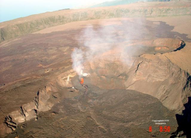
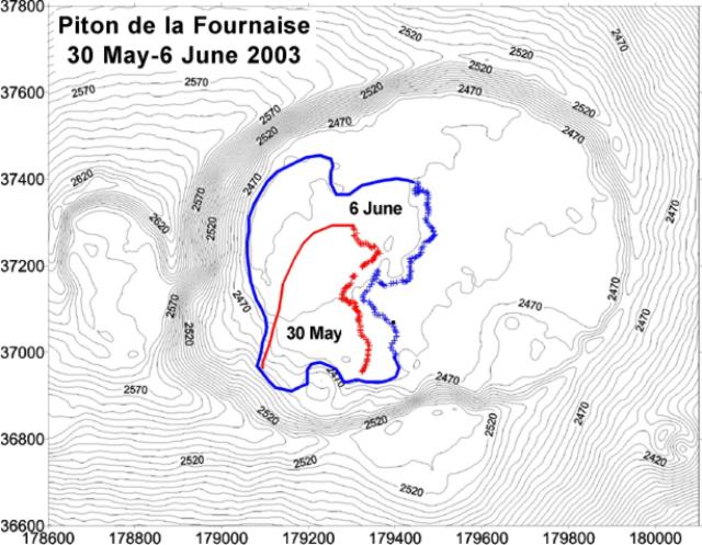
Fournaise, Piton de la (France)
Eruption on 30 May generates lava flows within Dolomieu crater
Karangetang (Indonesia)
Ash explosions from January through May 2003
Karymsky (Russia)
Frequent ash plumes generated from October 2002 through May 2003
Kilauea (United States)
Continued lava flows during December 2002-June 2003 enter the ocean
Lokon-Empung (Indonesia)
Increased explosive activity during January-April 2003; local ashfall
Mayon (Philippines)
Three small ash-and-steam explosions during April-May 2003
Monowai (New Zealand)
Volcanic earthquake swarm April-May detected by T-waves
Nyiragongo (DR Congo)
2002-2003 lava lake activity, thermal radiation, and CO2 and SO2 emissions
Ruapehu (New Zealand)
Steam plume issued from warm Crater Lake in May, but no eruption
Sabancaya (Peru)
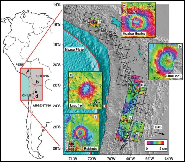
Inflation at Hualca Hualca detected by satellite surveys from June 1992 to April 1996
Santa Maria (Guatemala)
Lahars during January-October 2002; explosions and pyroclastic flows
Stromboli (Italy)
Lava effusion continues through mid-June; infrared satellite observations
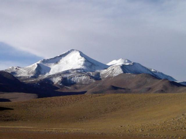
Uturuncu (Bolivia)
Deformation detected by satellite surveys; low-level seismicity and active fumaroles
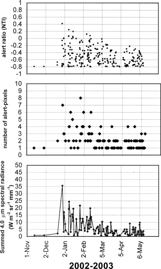
Anatahan (United States) — May 2003 Cite this Report
Anatahan
United States
16.35°N, 145.67°E; summit elev. 790 m
All times are local (unless otherwise noted)
Nearly continuous ash plumes through May
The explosive eruption that began on 10 May is the first documented eruption from Anatahan in historical time. There were no residents on the island due to their evacuation following a shallow earthquake swarm in 1990 (Moore and others, 1994), and another in 1993 (Sako and others, 1995). Anatahan is a composite volcano that erupts lavas that are primarily dacitic in composition. It has the largest caldera of the volcanoes in the Commonwealth of the Northern Mariana Islands (CNMI). The presence of this caldera indicates that large explosive eruptions are possible.
Strong activity continued over the next few days (BGVN 28:04), with high ash plumes seen in satellite imagery. The area within ~55 km of the island was also placed off-limits to all boats and aircraft not approved by the CNMI Emergency Management Office (EMO). A smaller but nearly continuous eruption column rose from the E crater of Anatahan for the next several weeks. Activity was continuing in early July, but at low levels.
The EMO invited USGS scientists to provide assistance in tracking the volcano's activity and assessing potential hazards shortly after the eruption began. USGS scientists first arrived in Saipan on 30 May to work directly with EMO officials to install and maintain monitoring equipment and interpret data from overflights and a single seismometer operating on Anatahan. This station became operational on 5 June.
Beginning of the eruption, 10-12 May 2003. On 6 May researchers from Washington University, Scripps Institution of Oceanography, and the EMO aboard the MV Super Emerald deployed a seismograph on Anatahan as part of a joint US-Japan Mariana Subduction Imaging Experiment, which is funded by the National Science Foundation. There were no indications of an impending eruption. During the night of 10-11 May the ship was again approaching Anatahan when scientists observed a tremendous lightning display ahead. As morning broke, they saw a pillar of steam and ash billowing to an altitude of 9 km. The ship had to detour around the island to avoid the ashfall.
Initial reports indicated that the eruption began around 2100 on 10 May. Satellite data interpreted by the Washington Volcanic Ash Advisory Center (VAAC) showed that the eruption appeared to have started by 1730. An ash plume was clearly visible in imagery at 2232, resulting in an advisory being issued to the aviation community at 2300 (1300 UTC). Plume heights were reported to be 10-12 km in the early stages of the eruption, with one ash advisory indicating ash to 13.4 km altitude on the 11th. At times multiple clouds were moving in different directions at different altitudes.
On 13 May Joe Kaipat from the CNMI Emergency Management Office (EMO) and seismologist Doug Weins (Washington University) flew to Sarigan (6.5 km W of Anatahan) to retrieve seismic data from a broadband instrument installed on 6 May. Records from the Sarigan station showed increased seismicity commencing at about 1300 on 10 May. The activity remained very strong for about 36 hours before decreasing.
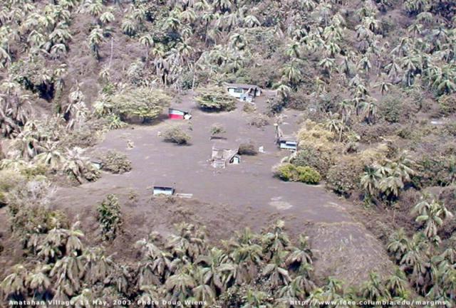
Activity during 13-30 May 2003. A helicopter overflight on 13 May showed that the island was still erupting, but with less intensity than on 11 May. Large volcanic bombs were observed flying high in the air over the crater region, and the whole W side of the island was covered with ash, including the seismograph site. The village appeared to have 15-30 cm of ash (figure 5). Ash advisories for 13-14 May reported that a dense ash cloud was drifting W away from the island, but that it was not continuous and varied in size. Ash plumes through 17 May generally drifted NW or WNW. The eruption clouds through May after the initial activity were generally below ~6 km.
On 18 May the EMO group took an overflight accompanied by David Hilton (Scripps Institution of Oceanography) and Tobias Fischer (University of New Mexico). They reported a rising plume comprised of steam and ash. The cloud was much lighter in color, with a reduced ash component compared to the initial phases of the eruption. Bombs, possibly up to several meters in size, were being tossed into the air; most fell back into the E crater. The ash was being blown W, but most of the ashfall was still on the E side of the island. The team landed on the E side of the island and deployed a PS- 2 seismometer that appears to have recorded earthquakes and some tremor. At that site they found ejecta thought to be from the initial stage of the eruption. The ground/vegetation near and under the ejecta was not scorched. Most of the material appeared to be non- juvenile. The largest fragments were up to 50 cm across. The team heard "booms" coming from the crater.
The ongoing explosive activity excavated a deep crater within Anatahan's E crater. Scientists estimated the inner crater was nearly at sea level by about 20 May; before the eruption, the floor of the E crater was 68 m above sea level. On 20 May the EMO group took an overflight and installed a telemetered seismic station. Pressure waves from detonations in the E crater were felt on the E flank. From a helicopter the team also observed rocks several meters across being thrown up above the E crater rim and falling back into the crater. Ash continued to fall on the western two-thirds of the island and out to sea. The ash cloud size and length was variable during 17-23 May; it continued in general to drift WNW from the island, at times spreading over a wide area.
On 23-24 May, typhoon Chan-hom shifted the prevailing east winds to the S, blowing the eruption column toward Saipan and Guam. Light ashfall resulted in flight cancellations and the closure of the Saipan and Guam international airports. Residents of Saipan reported a rotten egg smell associated with the ashfall. The report from Saipan was that 1-2 mm of ash had fallen on the island.
EMO personnel took an overflight on 27 May and reported that ash cloud heights reached 3 km, significantly lower than during the first few days of the eruption. The ash cloud was more opaque and laden with ash; the color was closer to that of 10-11 May than more recent plumes. The streaming ash cloud, still exhibiting variable size and length, drifted NW and NNW through 29 May.
Fieldwork on 21 May 2003. Hilton and Fischer arrived by ship at Anatahan at approximately 0630 on 21 May. The activity level was similar to that on their visit 2 days earlier. The ship sailed through the ashfall out to the SW side of the island, and continued along the W coast. The W coast was draped in ash; vegetation was completely covered giving the island a gray pallor. They landed at 0815 and spent ~4 hours ashore. A trench through the recent deposits on the beach area exposed a 25-cm section from the present eruptive phase with three main layers. The lowermost layer consisted of ~5 cm of fine-grained ash. Next was a layer ~15 cm thick comprised of accretionary lapilli with some fine ash. At the top was a 5-cm-thick layer that was a mixture of coarser grained ash and angular clasts of scoriaceous material. The abandoned village, where a team led by Patrick Shore (Washington University) was working on the seismic station installed on 6 May, was similarly covered in ash with many buildings having collapsed roofs. Two sections also revealed initial ash, covered by accretionary lapilli, then a mixture of ash and scoriaceous material. Pumice was floating in water-collection vessels by the buildings.
From the ship the scientists set up the COSPEC instrument and started a traverse through the plume around 1330. The telescope was oriented vertically and the ship made a N-to-S transect through the volcanic plume at a distance of ~1.5 km from shore. Sulfur dioxide (SO2) in the plume was recorded immediately. The transect took 50 minutes until no SO2 was being detected. In addition, they sailed through the ash fallout. During the traverse, the volcano erupted every 5 minutes with a deep resonating boom. The width of the volcanic plume was ~6 km and its direction was to the SW. From the COSPEC measurements and wind speed data provided by NOAA, the SO2 flux was estimated to be 3,000-4,500 metric tons/day. As the group sailed away from the island around 1430 there was a very large eruption with a significantly louder "boom" than had been heard previously, followed by a dark billowing ash-laden plume.
MODVOLC Thermal Alerts. Thermal satellite observations of the current eruption of Anatahan provided by the HIGP MODIS Thermal Alert Team (http://modis.higp.hawaii.edu) confirmed that activity was heavily concentrated in the E crater (figure 6). The most recent hot-spot (as of 1700 UTC on 28 May) was observed on 24 May. The large amounts of ash produced during the eruption will have obscured some thermal anomalies from the MODIS sensor. Plumes were clearly visible on MODIS imagery on 14, 21, 22, 25, 26, 28, and 30 May (figure 7). The persistent, long plume from this island volcano was frequently detected in imagery from a wide variety of satellite platforms.
SO2 data from TOMS. Simon Carn reported that the Earth Probe Total Ozone Mapping Spectrometer (EP TOMS) has observed SO2 and ash emissions from the ongoing eruption. No emissions were detected in the EP TOMS overpass at 0116 UTC on 10 May, several hours before the reported eruption onset. On May 11 a data gap over the Marianas prevented detection of proximal emissions, though a small ash cloud (no larger than ~120 km across) was detected ~500 km ESE of Anatahan at 0027 UTC. Washington VAAC estimates suggested a height of 14-15 km for this cloud. A weak SO2 cloud was also observed, displaced from the ash cloud and centered ~560 km SE of Anatahan. This cloud contained an estimated SO2 mass of ~10 kilotons (kt), but it is suspected to be only the distal end of a larger SO2 plume obscured by the data gap. Diffuse ash was also apparent at least 500 km W of the volcano at 0205 UTC, but no measurable SO2.
The EP TOMS orbit was better placed on 12 May at 0115 UTC. At this time an ash cloud extending ~560 km on its long axis was centered ~570 km W of Anatahan. An SO2 cloud, again displaced from the ash, extended ~1,100 km from a point ~510 km W of the volcano to a point ~700 km SE of it. This cloud contained ~110 kt of SO2. On 13 May a data gap covered the Marianas though ash was detected farther W, with no significant new SO2 evident. On 14 May a low-level SO2 plume appeared to be drifting W from Anatahan.
As of May 30 the Earth Probe TOMS instrument continued to detect significant SO2 emissions from Anatahan. No TOMS data were collected during 15-23 May due to a technical fault on the spacecraft. Thereafter, TOMS detected SO2 clouds in the region of Anatahan on 24 May (~19 kt SO2), 25 May (~23 kt minimum), 26 May (~35 kt), 28 May (~70 kt), and 30 May (~50-100 kt). Data gaps covered the Marianas on other days. Given the persistent ash plume from the volcano reported by the Washington VAAC, these SO2 clouds are presumed to be the product of continuous emissions and not discrete explosive events.
Observations from 20 May-8 June 2001. Anatahan was visited during 20 May-8 June 2001 as part of fieldwork in the Northern Marianas (Trusdell and others, 2001), including helicopter observations on 4 June. At that time line lengths on the Anatahan EDM network were measured and showed no significant changes. Most line lengths exhibited small contractions when compared to the data from the 1994 survey. Deformation appeared to be slowing down with no significant changes. Temperatures were measured for several boiling pots and springs on the floor of the E crater. The temperature of the ponds as well as fumaroles ranged from a minimum of 96.7°C to a maximum of 100.3°C.
References. Moore, R.B., Koyanagi, R.Y., Sako, M.K., Trusdell, F.A., Kojima, G., Ellorda, R.L., and Zane, S., 1994, Volcanologic investigations in the Commonwealth of the Northern Mariana Islands, September-October 1990: U.S. Geological Survey Open-File Report 91-320, 31 p.
Sako, M.K., Trusdell, F.A., Koyanagi, R.Y., Kojima, G., and Moore, R.B., 1995, Volcanic investigations in the Commonwealth of the Northern Mariana Islands, April to May 1994: U.S. Geological Survey Open-File Report 94-705, 57 p.
Trusdell, F.A., Sako, M.K., Moore, R.B., Koyanagi, R.Y., and Schilling, S., 2001, Preliminary studies of seismicity, ground deformation, and geology, Commonwealth of the Northern Mariana Islands, May 20 to June 8, 2001: U.S. Geological Survey, prepared for the Office of the Governor, the Emergency Management Office, and the Office of the Mayor of the Northern Islands, Commonwealth of the Northern Mariana Islands.
Wright, R., Flynn, L.P., Garbeil, H., Harris, A.J.L., and Pilger, E., 2002, Automated volcanic eruption detection using MODIS: Remote Sensing of Environment, v. 82, p. 135-155.
Geologic Background. The elongate, 9-km-long island of Anatahan in the central Mariana Islands consists of a large stratovolcano with a 2.3 x 5 km compound summit caldera. The larger western portion of the caldera is 2.3 x 3 km wide, and its western rim forms the island's high point. Ponded lava flows overlain by pyroclastic deposits fill the floor of the western caldera, whose SW side is cut by a fresh-looking smaller crater. The 2-km-wide eastern portion of the caldera contained a steep-walled inner crater whose floor prior to the 2003 eruption was only 68 m above sea level. A submarine cone, named NE Anatahan, rises to within 460 m of the sea surface on the NE flank, and numerous other submarine vents are found on the NE-to-SE flanks. Sparseness of vegetation on the most recent lava flows had indicated that they were of Holocene age, but the first historical eruption did not occur until May 2003, when a large explosive eruption took place forming a new crater inside the eastern caldera.
Information Contacts: Juan Takai Camacho and Ramon Chong, Commonwealth of the Northern Mariana Islands Emergency Management Office, P.O. Box 10007, Saipan, MP 96950 (URL: http://www.cnmihsem.gov.mp/); Frank Trusdell, Hawaiian Volcano Observatory, PO Box 51, Hawaii National Park, HI, 96718-0051 (URL: https://volcanoes.usgs.gov/nmi/activity/); Doug Wiens and Patrick Shore, Washington University, St. Louis, McDonnell Hall 403 Box 1169, St. Louis, MO 63130; Allan Sauter and David Hilton, Scripps Institution of Oceanography, UCSD, 9500 Gilman Drive, La Jolla CA, 92093-0225; Washington VAAC, Satellite Analysis Branch (SAB), NOAA/NESDIS E/SP23, NOAA Science Center Room 401, 5200 Auth Road, Camp Springs, MD 20746, USA (URL: http://www.ssd.noaa.gov/); Simon A. Carn, TOMS Volcanic Emissions Group, Joint Center for Earth Systems Technology (NASA/UMBC), University of Maryland Baltimore County, 1000 Hilltop Circle, Baltimore, MD 21250, USA (URL: https://so2.gsfc.nasa.gov/); Rob Wright, Luke Flynn, Harold Garbeil, Andy Harris, Matt Patrick, Eric Pilger, and Scott Rowland, Hawai'i Institute of Geophysics and Planetology, University of Hawai'i, 2525 Correa Road, Honolulu, HI 96822, USA (URL: http://modis.higp.hawaii.edu/); George Stephens, Operational Significant Event Imagery (OSEI) team, World Weather Bldg., 5200 Auth Rd Rm 510 (E/SP 22), NOAA/NESDIS, Camp Springs, MD 20748USA.
Cerro Blanco (Argentina) — May 2003 Cite this Report
Cerro Blanco
Argentina
26.7657°S, 67.746°W; summit elev. 4670 m
All times are local (unless otherwise noted)
Satellite surveys during May 1996-October 2000 indicate subsidence
A satellite-based interferometric synthetic aperture radar (InSAR) survey of the remote central Andes volcanic arc (Pritchard and Simons, 2002) revealed deformation in the Robledo caldera between May 1992 and October 2000 (figure 1). Subsidence was detected, with a maximum deformation rate in the radar line-of-sight of 2-2.5 cm/year. The subsidence rate seemed to be decreasing with time. The inferred source depth was 4.5-6 km below sea level. Additional details about the study and analysis are available in Pritchard and Simons (2002).
Reference. Pritchard, M., and Simons, M., 2002, A satellite geodetic survey of large-scale deformation of volcanic centres in the Central Andes: Nature, v. 418, p. 167-170.
Geologic Background. The Cerro Blanco volcanic complex contains the 5-km-diameter Cerro Blanco (or Robledo) caldera in NW Argentina, 80 km SW of the Cerro Galán caldera. Cerro Blanco was the site of the largest known Holocene eruption in the Central Andes about 4,200 years BP (Fernandez-Turiel et al., 2013). The rhyolitic Plinian eruption produced ashfall over about 110 km3 and widespread ignimbrite deposits. The large Cerro Blanco del Robledo lava dome overgrew the SW rim of the caldera and is surrounded by extensive rhyolitic pumice-fall deposits. Satellite geodetic surveys in the central Andes (Pritchard and Simons, 2002) showed subsidence of the caldera in the 1990s.
Information Contacts: Matthew Pritchard and Mark Simons, Division of Geological and Planetary Sciences, California Institute of Technology, Pasadena, CA 91125, USA (URL: http://www.gps.caltech.edu/).
Chikurachki
Russia
50.324°N, 155.461°E; summit elev. 1781 m
All times are local (unless otherwise noted)
Eruption continued through May; long plumes and some ashfall
The eruption that began on 18 April 2003 (BGVN 28:04) continued throughout May and into early June. According to observers, ash fell on the town of Severo-Kurilsk (~60 km from the volcano) on 1 May. Observers from Vasiliev Cape noted weak fumarolic activity on 3 May and satellite data from the USA and Russia that day revealed a gas-and-steam plume more than 150 km long and moving towards the ESE and S. Satellite data continued to show gas-and-steam plumes, possibly containing ash, throughout the remainder of May (table 1). Satellite imaging was obscured by clouds on other days. On 13 May, ash deposits were reported on the ENE and SSE flanks of the volcano and near the summit. At 1800 on 15 May, observers on Paramushir Island reported a strong ashfall at Podgorny settlement.
Table 1. Satellite data reports of gas-and-steam and ash plumes emanating from Chikurachki, May 2003. Courtesy of KVERT.
| Date |
Time (UTC) |
Estimated Plume Length (km) |
Direction |
| 05 May 2003 |
-- |
50 |
NW |
| 07/08 May 2003 |
-- |
150 |
E-SE |
| 12 May 2003 |
0019 |
20 |
SE |
| 12 May 2003 |
0449 |
156 |
E |
| 13 May 2003 |
0043 |
100 |
E |
| 13 May 2003 |
0102 |
70 |
SE |
| 13 May 2003 |
0200 |
50 |
E |
| 13 May 2003 |
0423 |
178 |
E-SE |
| 13 May 2003 |
0639 |
400 |
E-SE |
| 17 May 2003 |
-- |
50 |
SW |
| 18 May 2003 |
-- |
50 |
NE |
| 21 May 2003 |
-- |
10 |
NW |
| 27 May 2003 |
0600 |
100 |
NE |
| 27 May 2003 |
2200 |
100 |
NE |
| 29 May 2003 |
AM |
15-20 |
NE |
During the period 1930 to 2310 on 27 May, Leonid Kotenko on Paramushir Island reported that ash explosions attaining heights of 500 m above the crater were observed from Shelekhov Bay. The ash plume at 0900 on 28 May (2200 UTC, 27 May), rose 4,000 m above the crater. On 29 May an ash plume rose ~1,200 m above the crater and ash fell on the town of Severo-Kurilsk.
Additional information about the 2002 eruption. Previous KVERT reports indicated that the eruption that began on 25 January 2002 had continued through 16 March (BGVN 27:04), but no further reports were made about that activity. However, later information was received that showed the eruption continuing through at least 22 April. According to satellite data from AVO for 18 March, two consecutive GMS infrared images (1732 and 1832 UTC) showed a narrow, ~150-km-long cloud, which extended SE from Paramushir Island. There was no indication of ash based on the split-window technique. On the afternoon of 20 March, a gas-and-steam plume with some ash extended 200 km SE. Paramushir Island was obscured by clouds during the next 2 weeks. On 6 May L. Kotenko (A KVERT contact on the island) reported that hunters had observed fresh ash deposits on the SW flank on 22 April and that ashfall was also noted in Severo-Kurilsk.
Geologic Background. Chikurachki, the highest volcano on Paramushir Island in the northern Kuriles, is a relatively small cone constructed on a high Pleistocene edifice. Oxidized basaltic-to-andesitic scoria deposits covering the upper part of the young cone give it a distinctive red color. Frequent basaltic Plinian eruptions have occurred during the Holocene. Lava flows have reached the sea and formed capes on the NW coast; several young lava flows are also present on the E flank beneath a scoria deposit. The Tatarinov group of six volcanic centers is located immediately to the south, and the Lomonosov cinder cone group, the source of an early Holocene lava flow that reached the saddle between it and Fuss Peak to the west, lies at the southern end of the N-S-trending Chikurachki-Tatarinov complex. In contrast to the frequently active Chikurachki, the Tatarinov centers are extensively modified by erosion and have a more complex structure. Tephrochronology gives evidence of an eruption around 1690 CE from Tatarinov, although its southern cone contains a sulfur-encrusted crater with fumaroles that were active along the margin of a crater lake until 1959.
Information Contacts: Olga Girina, Kamchatka Volcanic Eruptions Response Team (KVERT), a cooperative program of the Institute of Volcanic Geology and Geochemistry, Far East Division, Russian Academy of Sciences, Piip Ave. 9, Petropavlovsk-Kamchatsky, 683006, Russia, the Kamchatka Experimental and Methodical Seismological Department (KEMSD), GS RAS (Russia), and the Alaska Volcano Observatory (USA); Alaska Volcano Observatory (AVO), a cooperative program of a) U.S. Geological Survey, 4200 University Drive, Anchorage, AK 99508-4667, USA (URL: http://www.avo.alaska.edu/), b) Geophysical Institute, University of Alaska, PO Box 757320, Fairbanks, AK 99775-7320, USA, and c) Alaska Division of Geological and Geophysical Surveys, 794 University Ave., Suite 200, Fairbanks, AK 99709, USA.
False Reports (Unknown) — May 2003 Cite this Report
False Reports
Unknown
Unknown, Unknown; summit elev. m
All times are local (unless otherwise noted)
Mongolia: Fumaroles and minor seismicity since October 2002
In December 2002 information appeared in Mongolian and Russian newspapers and on national TV that a volcano in Central Mongolia, the Har-Togoo volcano, was producing white vapors and constant acoustic noise. Because of the potential hazard posed to two nearby settlements, mainly with regard to potential blocking of rivers, the Director of the Research Center of Astronomy and Geophysics of the Mongolian Academy of Sciences, Dr. Bekhtur, organized a scientific expedition to the volcano on 19-20 March 2003. The scientific team also included M. Ulziibat, seismologist from the same Research Center, M. Ganzorig, the Director of the Institute of Informatics, and A. Ivanov from the Institute of the Earth's Crust, Siberian Branch of the Russian Academy of Sciences.
Geological setting. The Miocene Har-Togoo shield volcano is situated on top of a vast volcanic plateau (figure 1). The 5,000-year-old Khorog (Horog) cone in the Taryatu-Chulutu volcanic field is located 135 km SW and the Quaternary Urun-Dush cone in the Khanuy Gol (Hanuy Gol) volcanic field is 95 km ENE. Pliocene and Quaternary volcanic rocks are also abundant in the vicinity of the Holocene volcanoes (Devyatkin and Smelov, 1979; Logatchev and others, 1982). Analysis of seismic activity recorded by a network of seismic stations across Mongolia shows that earthquakes of magnitude 2-3.5 are scattered around the Har-Togoo volcano at a distance of 10-15 km.
Observations during March 2003. The name of the volcano in the Mongolian language means "black-pot" and through questioning of the local inhabitants, it was learned that there is a local myth that a dragon lived in the volcano. The local inhabitants also mentioned that marmots, previously abundant in the area, began to migrate westwards five years ago; they are now practically absent from the area.
Acoustic noise and venting of colorless warm gas from a small hole near the summit were noticed in October 2002 by local residents. In December 2002, while snow lay on the ground, the hole was clearly visible to local visitors, and a second hole could be seen a few meters away; it is unclear whether or not white vapors were noticed on this occasion. During the inspection in March 2003 a third hole was seen. The second hole is located within a 3 x 3 m outcrop of cinder and pumice (figure 2) whereas the first and the third holes are located within massive basalts. When close to the holes, constant noise resembled a rapid river heard from afar. The second hole was covered with plastic sheeting fixed at the margins, but the plastic was blown off within 2-3 seconds. Gas from the second hole was sampled in a mechanically pumped glass sampler. Analysis by gas chromatography, performed a week later at the Institute of the Earth's Crust, showed that nitrogen and atmospheric air were the major constituents.
The temperature of the gas at the first, second, and third holes was +1.1, +1.4, and +2.7°C, respectively, while air temperature was -4.6 to -4.7°C (measured on 19 March 2003). Repeated measurements of the temperatures on the next day gave values of +1.1, +0.8, and -6.0°C at the first, second, and third holes, respectively. Air temperature was -9.4°C. To avoid bias due to direct heating from sunlight the measurements were performed under shadow. All measurements were done with Chechtemp2 digital thermometer with precision of ± 0.1°C and accuracy ± 0.3°C.
Inside the mouth of the first hole was 4-10-cm-thick ice with suspended gas bubbles (figure 5). The ice and snow were sampled in plastic bottles, melted, and tested for pH and Eh with digital meters. The pH-meter was calibrated by Horiba Ltd (Kyoto, Japan) standard solutions 4 and 7. Water from melted ice appeared to be slightly acidic (pH 6.52) in comparison to water of melted snow (pH 7.04). Both pH values were within neutral solution values. No prominent difference in Eh (108 and 117 for ice and snow, respectively) was revealed.
Two digital short-period three-component stations were installed on top of Har-Togoo, one 50 m from the degassing holes and one in a remote area on basement rocks, for monitoring during 19-20 March 2003. Every hour 1-3 microseismic events with magnitude
Conclusions. The abnormal thermal and seismic activities could be the result of either hydrothermal or volcanic processes. This activity could have started in the fall of 2002 when they were directly observed for the first time, or possibly up to five years earlier when marmots started migrating from the area. Further studies are planned to investigate the cause of the fumarolic and seismic activities.
At the end of a second visit in early July, gas venting had stopped, but seismicity was continuing. In August there will be a workshop on Russian-Mongolian cooperation between Institutions of the Russian and Mongolian Academies of Sciences (held in Ulan-Bator, Mongolia), where the work being done on this volcano will be presented.
References. Devyatkin, E.V. and Smelov, S.B., 1979, Position of basalts in sequence of Cenozoic sediments of Mongolia: Izvestiya USSR Academy of Sciences, geological series, no. 1, p. 16-29. (In Russian).
Logatchev, N.A., Devyatkin, E.V., Malaeva, E.M., and others, 1982, Cenozoic deposits of Taryat basin and Chulutu river valley (Central Hangai): Izvestiya USSR Academy of Sciences, geological series, no. 8, p. 76-86. (In Russian).
Geologic Background. False or otherwise incorrect reports of volcanic activity.
Information Contacts: Alexei V. Ivanov, Institute of the Earth Crust SB, Russian Academy of Sciences, Irkutsk, Russia; Bekhtur andM. Ulziibat, Research Center of Astronomy and Geophysics, Mongolian Academy of Sciences, Ulan-Bator, Mongolia; M. Ganzorig, Institute of Informatics MAS, Ulan-Bator, Mongolia.
Piton de la Fournaise (France) — May 2003 Cite this Report
Piton de la Fournaise
France
21.244°S, 55.708°E; summit elev. 2632 m
All times are local (unless otherwise noted)
Eruption on 30 May generates lava flows within Dolomieu crater
Eruptions are common at Piton de la Fournaise, with the most recent activity occurring in January 2002 (BGVN 26:12) and November-December 2002 (BGVN 27:11). At the end of the November 2002 eruption, seimicity beneath Dolomieu crater increased from 28 November to 23 December. On 22 December there were 5,700 seismic events recorded. At 1002 on 23 December a magnitude 3 event occurred and seismicity stopped. The next day a new crater was observed in the SW part of the larger Dolomieu crater.
Since March 2003, the extensometer network and GPS measurements had indicated inflation of Piton de la Fournaise. A new eruption began on 30 May within Dolomieu crater. The eruption proceeded in multiple phases through at least 24 June; activity through 6 June is reported below.
Seismicity increased slightly on 28 May. At 1137 on the morning of 30 May a seismic crisis began that lasted 17 minutes with a total of 34 events. Tremor appeared at 1155 beneath Dolomieu crater, and an eruption started within the pit crater formed on 23 December 2002. Lava fountaining was observed until 1400, after which most surface activity stopped. A lava flow ~400 m long and 250 m wide extended into the W part of Dolomieu. The total volume of lava emitted during the 30 May activity was estimated to be 0.2-0.3 x 10⁶ m3. Seismicity beneath the crater continued, with intermittent weak tremor being registered through 3 June. No deflation was detected, and there was strong degassing in the collapse area.
On 4 June at 1155 the eruption started again from the same site, enlarging the lava flow in the W part of Dolomieu crater. Lava fountains reached 15 m in height. Steady lava emission continued into 6 June (figures 69 and 70). Volcanic tremor remained stable until the morning of 6 June, when a decreasing tendency was noted. After a short phreatic eruption, the second phase of this eruption stopped on the evening of 6 June. The lava-flow field had grown to ~600 x 400 m in size by that time (figure 71).
Geologic Background. Piton de la Fournaise is a massive basaltic shield volcano on the French island of Réunion in the western Indian Ocean. Much of its more than 530,000-year history overlapped with eruptions of the deeply dissected Piton des Neiges shield volcano to the NW. Three scarps formed at about 250,000, 65,000, and less than 5,000 years ago by progressive eastward slumping, leaving caldera-sized embayments open to the E and SE. Numerous pyroclastic cones are present on the floor of the scarps and their outer flanks. Most recorded eruptions have originated from the summit and flanks of Dolomieu, a 400-m-high lava shield that has grown within the youngest scarp, which is about 9 km wide and about 13 km from the western wall to the ocean on the E side. More than 150 eruptions, most of which have produced fluid basaltic lava flows, have occurred since the 17th century. Only six eruptions, in 1708, 1774, 1776, 1800, 1977, and 1986, have originated from fissures outside the scarps.
Information Contacts: Observatoire volcanologique du Piton de la Fournaise (OVPF), Institut de Physique du Globe de Paris, 14 RN3, le 27Km, 97418 La Plaine des Cafres, La Réunion, France.
Karangetang (Indonesia) — May 2003 Cite this Report
Karangetang
Indonesia
2.781°N, 125.407°E; summit elev. 1797 m
All times are local (unless otherwise noted)
Ash explosions from January through May 2003
During 6 January-4 May 2003 explosions produced ash that fell on various parts of the crater. The S (main) crater emitted "white-gray ash" that reached 150-400 m high. On some nights, a red glow was visible reaching 25-50 m over the crater. The N crater emitted a "white-thin ash" plume that reached 50-300 m high. Fluctuating seismicity was dominated by multiphase earthquakes and emissions (table 7). The Alert Level remained at level 3 (on a scale of 1 to 4) through at least 4 May.
Table 7. Seismicity at Karangetang during 6 January-4 May 2003. Courtesy VSI.
| Date |
Deep volcanic (A-type) |
Shallow volcanic (B-type) |
Explosion |
Multiphase |
Emission |
Tectonic |
Avalanche |
| 06 Jan-12 Jan 2003 |
11 |
16 |
2 |
178 |
178 |
28 |
-- |
| 13 Jan-19 Jan 2003 |
9 |
16 |
2 |
133 |
42 |
40 |
-- |
| 20 Jan-26 Jan 2003 |
12 |
37 |
-- |
189 |
52 |
27 |
-- |
| 27 Jan-02 Feb 2003 |
6 |
28 |
1 |
228 |
118 |
22 |
-- |
| 03 Feb-09 Feb 2003 |
17 |
84 |
1 |
162 |
306 |
23 |
-- |
| 10 Feb-16 Feb 2003 |
9 |
30 |
1 |
85 |
102 |
16 |
-- |
| 17 Feb-23 Feb 2003 |
9 |
46 |
-- |
97 |
8 |
32 |
-- |
| 24 Feb-02 Mar 2003 |
48 |
68 |
-- |
78 |
17 |
34 |
-- |
| 03 Mar-09 Mar 2003 |
19 |
29 |
1 |
48 |
9 |
24 |
398 |
| 10 Mar-16 Mar 2003 |
14 |
11 |
-- |
27 |
7 |
30 |
125 |
| 17 Mar-23 Mar 2003 |
24 |
145 |
-- |
82 |
4 |
23 |
4 |
| 24 Mar-30 Mar 2003 |
21 |
68 |
-- |
35 |
1 |
33 |
2 |
| 31 Mar-06 Apr 2003 |
8 |
83 |
-- |
30 |
-- |
36 |
-- |
| 07 Apr-13 Apr 2003 |
18 |
143 |
-- |
116 |
6 |
50 |
-- |
| 14 Apr-20 Apr 2003 |
12 |
257 |
32 |
226 |
26 |
32 |
7 |
| 21 Apr-27 Apr 2003 |
13 |
373 |
2 |
93 |
6 |
17 |
309 |
| 28 Apr-04 May 2003 |
32 |
255 |
-- |
243 |
1 |
21 |
29 |
On 11 and 12 January, ash explosions at the S crater were accompanied by glowing material that reached 200 m high and scattered 500 m toward the E and W parts of the crater. An ash column rose up to 500 m above the crater. Two explosions at the S crater on 14 January produced an ash column up to 300 m high; glowing material rose up to 50 m and fell around the crater. Some of the material entered the Beha River, and ash fell into the sea E of the island. Explosions on 29 January and 6 February caused ashfall SW (Beong village) and SSW (Akesembeka village, Tarurane, Tatahadeng, Bebali, and Salili), respectively. A booming noise was heard frequently throughout the report period, and during early February was sometimes accompanied by thick gray emissions up to 350 m above the crater.
Beginning in early March, the booming noise was accompanied by glowing lava avalanches that traveled from the summit towards the Kahetang (1,250 m), Batuawang (750 m), Batang (1,000 m), and Beha (750 m) rivers. On 6 March an explosion from the S crater ejected ash 750 m high that fell in the E part of the crater. The noises and avalanches decreased during mid-to-late March.
An explosion on 15 April was followed by lava avalanches toward the W and S parts of the crater. A loud blasting sound was heard, and a dark-gray ash column reached 1,500 m. Ash fell to the E around Dame and Karalung villages, and over the sea. Lava avalanches from the S crater traveled 1,000 m toward the Batang and Batu rivers. On 20 April another explosion produced a 1,500-m-high ash column, and ash fell E over the sea. This explosion was followed by lava avalanches and a pyroclastic flow toward the Batang river that reached as far as 2,500 m. Lava avalanches extended 1,500 m down the S and W slopes. Blasting noises occurred for about 3 minutes.
On 22 April an explosion ejected ash and glowing material. The ash column reached 1,750 m and ash fell on the W slope, including Lehi, Mini, Kinali, and Hiung villages, while glowing material rose up to 750 m. This explosion was followed by lava avalanches towards the W and S that were accompanied by a pyroclastic flow toward the Batang river that extended 2,250 m. On 24 April, an explosion ejected ash to 750 m and ash fell eastward into the sea. Glowing material from the explosion traveled toward the W slope. During late April, the booming noises were once again accompanied by continuous glowing avalanches. These decreased during the first days of May.
Geologic Background. Karangetang (Api Siau) volcano lies at the northern end of the island of Siau, about 125 km NNE of the NE-most point of Sulawesi. The stratovolcano contains five summit craters along a N-S line. It is one of Indonesia's most active volcanoes, with more than 40 eruptions recorded since 1675 and many additional small eruptions that were not documented (Neumann van Padang, 1951). Twentieth-century eruptions have included frequent explosive activity sometimes accompanied by pyroclastic flows and lahars. Lava dome growth has occurred in the summit craters; collapse of lava flow fronts have produced pyroclastic flows.
Information Contacts: Volcanological Survey of Indonesia (VSI), Jalan Diponegoro No. 57, Bandung 40122, Indonesia (URL: http://www.vsi.esdm.go.id/).
Karymsky
Russia
54.049°N, 159.443°E; summit elev. 1513 m
All times are local (unless otherwise noted)
Frequent ash plumes generated from October 2002 through May 2003
According to the Kamchatka Volcanic Eruptions Response Team (KVERT), the alert level Color Code remained at Yellow (volcano is restless; eruption may occur) from October 2002 to 27 February 2003, when it was dropped to Green (volcano is dormant; normal seismicity and fumarolic activity). The level was raised again to Yellow in March, lowered to Green on 29 March, and raised to Yellow on 18 April, where it remained through May. Seismicity was above background levels until 20 February, after which it fluctuated between at and above background levels until 16 May, when seismicity remained above background levels. All times are local (= UTC + 11 hours, + 12 hours after 26 October).
Activity during October 2002. From 4 to 31 October, ~200-250 local shallow seismic events occurred per day. The character of the seismicity indicated ash-and-gas explosions to heights of 1,000 m above the volcano (~2,500 m altitude) and gas blow-outs. A faint 10-km-long plume extending SSE was visible in an AVHRR satellite image; no ash was detected. Seismicity on 25-26 October indicated possible vigorous gas emissions lasting 5-10 minutes, with the probability of a lava flow. At 1350 on 31 October, pilots reported that an ash plume rose 4 km and extended SE. According to seismic data from the Kamchatka Experimental and Methodical Seismological Department (KEMSD), the character of seismicity after 1400 on 31 October indicated a moving lava flow. At 1314 on 31 October, the MODIS satellite image showed a large bright thermal anomaly at the volcano and a plume ~60 km long that extended WSW. At 1100 on 1 November, pilots reported that an ash plume rose 4 km and extended SE.
Activity during November 2002. Local shallow seismic events totaled ~200-250 each day. The character of the seismicity indicated ash-and-gas explosions to heights of 1,000-2,000 m above the volcano and vigorous gas emissions lasting 5-10 minutes. At 1605 on 1 November, a 50-km-long plume was observed extending E in satellite imagery; no ash was detected. According to data from KEMSD, at 2357 on 20 November, a seismic event lasting 20 minutes indicated that ash explosions to heights of 1,000 m above the crater and hot avalanches possibly occurred. On 27 November, a >100-km gas-and-steam plume extending ESE from the crater of the volcano was observed in MODIS satellite imagery. Helicopter observations by KVERT scientists at 1151 on 1 December identified an ash plume to ~500 m above the crater extending SE.
Activity during December 2002. Local shallow seismic events totaled ~190-230 each day. The character of seismicity indicated that ash-gas explosions to heights of 1,000 m above the volcano (~2,500 m altitude) and vigorous gas emissions lasting 5-10 minutes were possibly occurring. The top of the volcano and its SE flank were covered with recent ashfall and debris from continuing Vulcanian / Strombolian eruptions. The old crater was covered by the new cinder-ash cone. On 12 December, two sectors of ash falls extending S and SE from the volcano were noted in a MODIS satellite image.
Activity during January 2003. Local shallow seismic events totaled ~110-200 each day. The character of seismicity indicated that ash-gas explosions to heights of 1,000 m above the volcano (~2,500 m or 8,200 ft. ASL) and vigorous gas emissions lasting 5-10 minutes were possibly occurring. From 1559 until 1609 on 8 January, a series of shallow events that possibly indicated hot avalanches were registered. On 9 January, a ~50-km plume extending ESE from the volcano was noted.
Activity during February 2003. The alert level Color Code remained at Yellow until 27 February, when it was lowered to Green (volcano is dormant; normal seismicity and fumarolic activity). According to satellite data from Russia, a weak thermal anomaly was noted on 3 February. Seismic activity was at background levels on 20-23 February.
Activity during March 2003. The alert level Color Code was raised to Yellow as the activity of the volcano slightly increased. Seismic activity was at background levels on 13-18 March and slightly above background levels on 19 March when seismic data indicated possible hot avalanches. Weak volcanic earthquakes were also registered on this day. According to MODIS-satellite data from Russia and the USA, ash deposits extending more than 30 km SW from the volcano on 17-20 March and gas-steam plumes drifting more than 15 km NW and SW on 18 March and on 20 March, respectively, were noted. Seismic activity dropped to background levels for the week of 20 March. According to satellite data from Russia, a weak thermal anomaly was observed on 25 March, and a gas-and-steam plume extending 10 km ESE was noted on 28 March. According to helicopter observations on 31 March by the Institute of Volcanology (IV), Far East Division, Russian Academy of Sciences, the large old active crater of the volcano and its black ESE flank were noted, but the new cinder-ash cone was not seen. This cone was probably destroyed and its products formed ash-deposits extending >35 km ESE, which were noted on the 17-18 March MODIS-satellite images.
Activity during April 2003. The alert level Color Code was dropped to Green during the week of 29 March-4 April, when seismic activity was at background levels. Seismicity rose above background levels during the week of 18-24 April, when ~40-100 volcanic earthquakes per day were recorded, and the hazard status was raised to Yellow. The character of the seismicity indicated ash-and-gas explosions up to 1,000 m above the crater. According to satellite data from Russia, ash deposits up to 35 km or longer extended in different directions on 19-22 April. According to observers from IV, on 18-24 April occasional ash-gas explosions up to 2,500 m above the crater occurred each day, and on 21 April, an ash-gas plume rose 1,500 m. Seismic activity was above background levels on 24-27 April and at background levels on 27-30 April. During 24-26 April 50-100 volcanic earthquakes per day were registered. The character of the seismicity indicated that three eruption events (possibly ash-and-gas explosions and rock avalanches) occurred on 24 April. According to satellite data from Russia, wide ash deposits longer than 35 km and three narrow ash deposits less than 5 km long extending SE and W and SW from the volcano, respectively, were noted on 25 April and 28-29 April. According to observers from IV FED RAS, on 24 April, an ash-gas plume rose 2,500 m above the crater.
Activity during May 2003. The alert level Color Code remained at Yellow for the month, with intermittent explosive eruptions continuing. Occasional explosions up to 1,500 m above the volcano, producing ash, were considered to be possible, as well as ashfall within a few tens of kilometers. Seismic activity was at background levels during 3-16 May. According to satellite data from Russia, the summit of the volcano was black on 4 May. For the week of 10-16 May, seismic data indicated that 10 ash-and-gas explosions reached heights up to 1,000 m above the crater, and hot avalanches possibly occurred. According to satellite data from the USA and Russia, a weak 1-pixel thermal anomaly on 14 May, and strips of ash deposits extending >10 km to the S, SSE and SE on 14-15 May were noted. Seismicity was above background levels on 16-30 May.
During 18-21 May, 150-320 local shallow events occurred per day. The character of the seismicity indicated ash-and-gas explosions to heights of 1,000 m above the volcano, gas blow-outs and hot avalanches. According to satellite data from the USA and Russia, a 2-4-pixel thermal anomaly was observed during 18-22 May. Ash deposits on snow E and SE of the volcano were noted on 18 May. Gas-steam plumes extending up to 45 km NE and N of the volcano on 19 and 21 May were noted. For the week of 24-30 May, 280-330 local shallow seismic events occurred per day. The character of the seismicity indicated ash-and-gas explosions to heights of 1,000 m and gas blow-outs. A thermal anomaly continued to be observed. On 25-26 May, gas-and-steam plumes extending 15-115 km SSE from the volcano were noted. Ash deposits on the snow in a different direction from the volcano were noted on 26-27 May.
Geologic Background. Karymsky, the most active volcano of Kamchatka's eastern volcanic zone, is a symmetrical stratovolcano constructed within a 5-km-wide caldera that formed during the early Holocene. The caldera cuts the south side of the Pleistocene Dvor volcano and is located outside the north margin of the large mid-Pleistocene Polovinka caldera, which contains the smaller Akademia Nauk and Odnoboky calderas. Most seismicity preceding Karymsky eruptions originated beneath Akademia Nauk caldera, located immediately south. The caldera enclosing Karymsky formed about 7600-7700 radiocarbon years ago; construction of the stratovolcano began about 2000 years later. The latest eruptive period began about 500 years ago, following a 2300-year quiescence. Much of the cone is mantled by lava flows less than 200 years old. Historical eruptions have been vulcanian or vulcanian-strombolian with moderate explosive activity and occasional lava flows from the summit crater.
Information Contacts: Olga Girina, Kamchatka Volcanic Eruptions Response Team (KVERT), a cooperative program of the Institute of Volcanic Geology and Geochemistry, Far East Division, Russian Academy of Sciences, Piip Ave. 9, Petropavlovsk-Kamchatsky, 683006, Russia, the Kamchatka Experimental and Methodical Seismological Department (KEMSD), GS RAS (Russia), and the Alaska Volcano Observatory (USA); Alaska Volcano Observatory (AVO), a cooperative program of a) U.S. Geological Survey, 4200 University Drive, Anchorage, AK 99508-4667, USA (URL: http://www.avo.alaska.edu/), b) Geophysical Institute, University of Alaska, PO Box 757320, Fairbanks, AK 99775-7320, USA, and c) Alaska Division of Geological and Geophysical Surveys, 794 University Ave., Suite 200, Fairbanks, AK 99709, USA.
Kilauea (United States) — May 2003 Cite this Report
Kilauea
United States
19.421°N, 155.287°W; summit elev. 1222 m
All times are local (unless otherwise noted)
Continued lava flows during December 2002-June 2003 enter the ocean
From December 2002 through June 2003, lava from Kīlauea continued to flow down the S flanks and into the ocean at several points. Seismicity generally continued at normal (background) levels. The Mother's Day flow, which began erupting 12 May 2002, continued through June 2003 (figure 158).
Lava flows. During December 2002, lava continued to flow into the sea at entry points from two lava deltas. Moderate-to-large littoral explosions tossed spatter onto the front of the West Highcastle delta. Surface lava flows were visible on the coastal flat. On 15 December, shortly after 0700, the Wilipe'a lava delta partially collapsed, losing about 1/3 of its area. The tip of the delta retreated shoreward about 260 m and most of the collapse was in the central part of the delta. Around 15 and 16 December a substantial collapse occurred at the West Highcastle delta. On 28 December moderate collapses occurred at the Wilipe'a lava delta, apparently in the area of the 15 December collapse. Surface lava flows were visible on the coastal flat and upslope on Pulama pali.
During January and February 2003, lava continued to flow into the sea at the West Highcastle entry. Surface lava flows were visible on the coastal flat and upslope of it on Paliuli. Most of the surface lava flows on the coastal flat crusted over, so that less incandescence was visible than previously. Relatively large surface lava flows were visible starting on 21 January around 2035. Around 28 January a large lava breakout occurred from the West Highcastle lava tube about 170 m inland from the old sea cliff. As of 2 February the area of the new breakout was about 6.15 hectares (6.15 x 10⁴ m2), and surface flows and lava in lava tubes traveled down the Pulama pali fault scarp. The Chain of Craters road was closed due to a wildfire that was started by lava flows. Surface lava flows continued to travel through vegetation, igniting fires and causing methane explosions. Rangers' office huts, restrooms, and signs were moved out of the path of the lava flow, which reached the Chain of Craters Road on 19 February at 1005. Beginning 15 February and going into March, lava flowed into the sea at the Kohala entry. Fresh lava oozed out of the cooling Kohala lava flow, both within the body of the flow and along its E margin.
During 26 February to 3 March lava continued to enter the sea at the West Highcastle entry, but the lava-flow rate was reduced to a small trickle at the Kohala entry. Small surface flows occurred along the W edge of the Kohala lava flow and surface lava flows were visible above the Pulama pali fault scarp. Tongues of lava were visible traveling down Pulama pali, part of the activity that began on 12 May 2002 (named the Mother's Day flow).
Through April 2003, Kīlauea continued to erupt, sending lava down its SE flank either traveling over the land surface or through tubes. Lava entered the sea at the West Highcastle entry; activity there was sometimes weak, though one or more glowing areas were typically seen. On 16 April a large tract of land not over-run by surrounding lava (a kipuka or ahu in the local parlance) remained within the Kohola lava flow, still ~30 cm above the top of inflated lavas that surround it. On the eastern margin of the swath of lava flows going down the steep slopes of Pulama pali, one partly crusted-over lava stream was highly visible. The crater of Pu`u `O`o was dark and obscured by fumes, but eruptive activity at Pu`u `O`o continued unabated. The flows on Pulama pali were frequently visible at night as streams of incandescence from the top of the pali down to the coastal flats. Late in April, the E arm of the Mother's Day flow split in two with the W segment being more active. A new ocean entry near Lae'apuki only lasted a day before the flow stagnated. Scattered surface breakouts were seen throughout the inflating Kohola flow, especially on its W side. As of 24 April, lava entered the ocean at two points along the West Highcastle delta.
In early May, lava flows continued to descend the S flanks and pour into the sea. On 12 May lava began to enter the sea again at the West Highcastle lava delta. Surface lava flows were visible on the coastal flat and the Pulama Pali fault scarp. During June, lava continued to flow down Kīlauea's SE flank, with surface lava flows occasionally visible on the coastal flat and upslope at Pulama pali, and Paliuli. Small amounts of lava continued to flow into the sea at Highcastle beach.
Geophysical activity. During December 2002 and January 2003, seismicity was generally at normal levels. The swarm of long-period earthquakes and tremor beneath Kīlauea's caldera, occasionally seismically active since June 2002, continued to show some short bursts of tremor interspersed with small earthquakes. Small inflation and deflation events occurred at Pu`u `O`o and Uwekahuna tilt meters. The Pu`u `O`o tiltmeter showed deflation for about one week from 10 to 17 December. During 27-28 December, slight deflation occurred at the Uwekahuna and Pu`u `O`o tiltmeters.
Kīlauea's summit began to deflate on 20 January 2003 at 1710, and Pu`u `O`o began to deflate a few tens of minutes later. Both areas deflated well into the next day. On the 21st at 1610 rapid, brief inflation began at the summit. The inflation and preceding deflation were centered near the NE corner of Halemaumau Crater, the normal center of small deformation events. Seismicity increased with the deformation events, returning to normal levels afterwards. By 22 January seismicity had returned to its normal level, with the long-lasting swarm of long-period earthquakes and tremor at Kīlauea's summit continuing at weak-to-moderate levels.
During February and March, seismicity was at background levels. The long-lasting swarm of long-period earthquakes and tremor at Kīlauea's summit continued at low-to-moderate levels. On 9 and 10 February, short periods of deflation and inflation occurred at the Uwekahuna and Pu`u `O`o tiltmeters. Moderate tremor was recorded by the nearest seismometer to Pu`u `O`o until the seismometer broke on 5 March. Moderate deflation occurred on 8 March, first at the Uwekahuna tiltmeter and then at the Pu`u `O`o tiltmeter. According to a news report, a member of a tour group suffered burns on 10 March when he fell on hot lava while hiking near Chain of Craters road.
For about a week in early April, volcanic tremor at Pu`u `O`o was relatively high and small deformation changes occurred, mostly at Pu`u `O`o. During 16-17 April, the Uwekahuna tiltmeter at Kīlauea's summit recorded three small inflations, the last apparently right at its crest. Pu`u `O`o has generally followed suit, though in this case showing only two of the inflations very well. These tilts are not major but continue to illustrate the clear connection between Kīlauea's summit, where most tilt events start, and Pu`u `O`o, 20 km away, where the tilt events follow a few minutes later. Seismicity during the week was at low to normal levels. Instruments continued to register the summit swarm of long-period earthquakes and tremor, which began last June. Volcanic tremor at Pu`u `O`o remained elevated, as has been the norm for more than a week.
During 30 April to 6 May, distances measured across Kīlauea caldera between two points ~10 km apart, remained stable as they have since early 2003. There had been consistent progressive lengthening of this distance during late 2001 through mid-2002, and some minor fluctuations after that. In general, tilt during late April through 2 May changed little at Uwekahuna station (W side of the caldera), and showed a progressive decline at Pu`u `O`o station (E of the caldera). In the first few days of May slight inflationary tilt appeared at both stations.
Seismicity at Kīlauea's summit was at moderate-to-high levels from about 1 June through 14 June, with many small, low-frequency earthquakes occurring at shallow depths beneath the summit caldera. The tiny earthquakes occurred at the notably high rate of 2-4 per minute. Little or no volcanic tremor accompanied the swarm, however. Volcanic tremor at Pu`u `O`o remained moderate to high, as is the norm. A quasi-cyclic inflation and deflation occurred at Kīlauea's summit and at Pu`u `O`o during the week of 6-13 June, but did not culminate in significant overall tilt.
Geologic Background. Kilauea overlaps the E flank of the massive Mauna Loa shield volcano in the island of Hawaii. Eruptions are prominent in Polynesian legends; written documentation since 1820 records frequent summit and flank lava flow eruptions interspersed with periods of long-term lava lake activity at Halemaumau crater in the summit caldera until 1924. The 3 x 5 km caldera was formed in several stages about 1,500 years ago and during the 18th century; eruptions have also originated from the lengthy East and Southwest rift zones, which extend to the ocean in both directions. About 90% of the surface of the basaltic shield volcano is formed of lava flows less than about 1,100 years old; 70% of the surface is younger than 600 years. The long-term eruption from the East rift zone between 1983 and 2018 produced lava flows covering more than 100 km2, destroyed hundreds of houses, and added new coastline.
Information Contacts: Hawaiian Volcano Observatory (HVO), U.S. Geological Survey, PO Box 51, Hawaii National Park, HI 96718, USA (URL: https://volcanoes.usgs.gov/observatories/hvo/).
Lokon-Empung (Indonesia) — May 2003 Cite this Report
Lokon-Empung
Indonesia
1.358°N, 124.792°E; summit elev. 1580 m
All times are local (unless otherwise noted)
Increased explosive activity during January-April 2003; local ashfall
During 6 January-4 May 2003, higher-than-normal activity was dominated by deep and shallow volcanic earthquakes (table 5), along with gas-and-ash emissions. Several explosions occurred during a period of increased activity in late January-early April. Throughout the report period, a "white-thick ash" emission rose 25-500 m above Tompaluan crater. The Volcanological Survey of Indonesia (VSI) issued a special report during 1-13 February 2003 that described activity in 2002 and early 2003 leading up to the recent increase in activity (table 6).
Table 5. Seismicity at Lokon during 6 January-4 May 2003. Courtesy VSI.
| Date |
Deep volcanic (A-type) |
Shallow volcanic (B-type) |
Emission |
Tectonic |
Explosion |
| 06 Jan-12 Jan 2003 |
1 |
6 |
10 |
13 |
-- |
| 13 Jan-19 Jan 2003 |
1 |
3 |
-- |
20 |
-- |
| 20 Jan-26 Jan 2003 |
8 |
6 |
4 |
23 |
-- |
| 27 Jan-02 Feb 2003 |
6 |
4 |
31 |
11 |
-- |
| 03 Feb-09 Feb 2003 |
239 |
763 |
4 |
9 |
-- |
| 10 Feb-16 Feb 2003 |
32 |
23 |
7 |
14 |
4 |
| 17 Feb-23 Feb 2003 |
239 |
763 |
4 |
9 |
1 |
| 24 Feb-02 Mar 2003 |
97 |
353 |
52 |
19 |
12 |
| 03 Mar-09 Mar 2003 |
-- |
3 |
185 |
6 |
2 |
| 10 Mar-16 Mar 2003 |
-- |
-- |
90 |
14 |
-- |
| 17 Mar-23 Mar 2003 |
2 |
4 |
38 |
17 |
-- |
| 24 Mar-30 Mar 2003 |
49 |
335 |
33 |
7 |
1 |
| 31 Mar-06 Apr 2003 |
7 |
130 |
5 |
18 |
1 |
| 07 Apr-13 Apr 2003 |
4 |
15 |
86 |
17 |
-- |
| 14 Apr-20 Apr 2003 |
44 |
285 |
-- |
17 |
-- |
| 21 Apr-27 Apr 2003 |
46 |
98 |
-- |
14 |
-- |
| 28 Apr-04 May 2003 |
25 |
71 |
-- |
24 |
-- |
Table 6. Summary of a special report of activity at Lokon during 2002-2003. Courtesy VSI.
| Date |
Event |
| 09 Feb 2002 |
An explosion ejected ash to ~ 1,000 m above the crater. Ash fell on Kakaskasen, Telete, and Rurukan villages in the Tondano District in thicknesses of 0.5-2 cm. |
| 10 Apr 2002 |
At 2302 volcanic earthquakes began to increase, reaching a total of 184 events. An explosion at the same time ejected ash to ~ 1,000 m and glowing material to 250 m above the crater. Ash fell on some villages in thicknesses of 1-3 mm. |
| 12 Apr 2002 |
At 1816 an explosion ejected ash to 800 m and glowing material to 150 m. Ash drifted S and fell around Kayawu village. |
| 23 Dec 2002 |
At 0532 an explosion at Tompaluan crater produced an 800-m-high ash column. Ash drifted S and fell around the edifice. Before the explosion, an increase in seismicity (130 volcanic earthquakes in less than 12 hours) was noted. |
| 03 Feb 2003 |
Volcanic earthquakes began to increase, with a total of 255 events occurring through 7 February. |
| 08 Feb 2003 |
Tremor was followed by an explosion at 0443 that ejected ash to 1,400 m above the crater. The ash drifted S and was accompanied by glowing material. Ash fell around Taratara, Waloan, and Kayawu villages, at thicknesses of 0.5-1 cm. |
| 10 Feb 2003 |
After two days repose, at 2219 an explosion occurred. The height of the ash column could not be observed due to heavy rain near the summit. The explosion was preceded by a booming sound. Based on seismograph recordings, the explosion was of medium-high intensity. Explosion earthquakes stopped at 2335. A phreatic eruption at 1406 lasted for 8 minutes. |
| 12 Feb 2003 |
A significant increase in volcanic earthquakes, mainly during 0100-1000. An explosion at 1408 was followed by a larger explosion at 1102 (based on seismic data; visual observation obscured by thick fog). At 1133 the explosion diminished. At 1225 continuous tremor began with amplitudes of 13-55 mm that continued until 0046 on 13 February. |
On 25 January, there was a felt shock (I on the MMI scale). During late January, ash emissions from the crater thickened and emission earthquakes increased. On 3 February the number of deep volcanic earthquakes began to increase at 0600; by 1000, 35 had occurred.
Ash emissions continued to thicken and deep and shallow volcanic earthquakes increased during early February. Emission earthquakes also increased, indicating some low ash explosions. On 8 February at 0443 an explosion ejected ash and glowing material. A booming sound was heard for 30 seconds. A dense ash cloud reached 1,400 m above the crater. Ash fell over the S part of the crater and around Kayau, Tara-tara I and II, and Woloan II and III villages. Ashfall reached thicknesses of 0.5-1 mm. The Alert Level was increased from 2 to 3 (on a scale of 1-4).
Explosions occurred on 10 February at 1405 and 2219. The maximum amplitude of the explosion earthquakes was 50 mm. The height of the ash column could not be observed due to heavy rain. Explosion activity continued on 12 and 16 February. VSI reported that the Alert Level was increased to 4 on 12 February at 0800. From that time through 1100 on 12 February, shallow volcanic earthquakes increased to a total of 164. An explosion followed at 1102, but the ash column could not be observed due to heavy rain. Tremor was recorded beginning on 13 February with amplitudes of 0.5-38 mm.
VSI reported that during 18-20 February, there were 16 explosions and a "white-gray ash" column rose 500 m. An explosion on 22 February was preceded by a swarm of 224 shallow volcanic earthquakes. On 21 February, 29 deep volcanic earthquakes occurred. Within two days, the number of volcanic earthquakes decreased gradually and ended with a large explosion on 23 February at 1034. The explosion was accompanied by thundering and a booming sound, and a "thick-gray ash" column reached 2,500 m above the crater. Ash drifted toward the SE. Tremor (with an amplitude of 1-20 mm) began soon after the explosion. Lokon was at Alert Level 3 during 17-23 February.
During 24 February-2 March, 12 explosions occurred and a "white-gray ash" column rose 300 m. An explosion on 2 March at 2129 was accompanied by glowing material that fell within the crater. A dark gray ash column rose 1,500 m above the crater and ash fell toward the Tondano area (~14.5 km from the crater) with a thickness of ~1 mm. Tremor (with amplitudes of 0.5-25 mm) began soon after the explosion. The explosion had been preceded by a swarm of 204 shallow volcanic earthquakes. A total of 77 deep volcanic earthquakes occurred during 26 February-1 March 2003. Following the 2 March explosion, there were 2 medium-intensity explosions that produced a ~600-m-high "white-gray ash" column.
Ash explosions and emission earthquakes ended on 14 March. On 24 March, the Alert Level was lowered to 2. Normal activity continued, comprised mainly of "white-thick ash" emissions from Tompaluan crater that reached up to 300 m. Tremor continued with amplitudes of 0.5-12 mm.
On 27 March at 0156, an explosion produced a 1,500-m-high ash column that was accompanied by glowing material. Booming and blasting sounds were heard. Ash drifted S and some fell around the edifice, while glowing material reached 400 m high before falling around the crater. Activity was low after the explosion. Tremor continued with amplitudes of 0.5-24 mm.
Following another explosion on 1 April, activity at Lokon decreased. A "white-thick ash" plume continued to rise 100-450 m above the crater. Seismicity was dominated by tremor with amplitudes of 0.5-25 mm. Shallow volcanic earthquakes increased on 15 April to 106 events. Through 20 April, the daily number of shallow volcanic earthquakes fluctuated between 23 and 56 events, but there were no explosions. Activity remained low, but above normal, through at least 4 May.
Geologic Background. The Lokong-Empung volcanic complex, rising above the plain of Tondano in North Sulawesi, includes four peaks and an active crater. Lokon, the highest peak, has a flat craterless top. The morphologically younger Empung cone 2 km NE has a 400-m-wide, 150-m-deep crater that erupted last in the 18th century. A ridge extending 3 km WNW from Lokon includes the Tatawiran and Tetempangan peaks. All eruptions since 1829 have originated from Tompaluan, a 150 x 250 m crater in the saddle between Lokon and Empung. These eruptions have primarily produced small-to-moderate ash plumes that sometimes damaged croplands and houses, but lava-dome growth and pyroclastic flows have also occurred.
Information Contacts: Volcanological Survey of Indonesia (VSI), Jalan Diponegoro No. 57, Bandung 40122, Indonesia (URL: http://www.vsi.esdm.go.id/).
Mayon
Philippines
13.257°N, 123.685°E; summit elev. 2462 m
All times are local (unless otherwise noted)
Three small ash-and-steam explosions during April-May 2003
The Philippine Institute of Volcanology and Seismology (PHIVOLCS) reported small ash and steam explosions from the Mayon volcano on 5 April, 6 May, and 14 May 2003. The alert status for the area around the volcano remained at Alert Level 1 on a scale of 0-5 (indicating an increased likelihood for steam-driven or ash explosions to occur with little or no warning). PHIVOLCS reminded the public to continue avoiding entry into the 6-km-radius Permanent Danger Zone (PDZ), especially in the sectors where life-threatening volcanic flows might be channeled by gullies.
Activity during April 2003. Following a small ash explosion on 17 March 2003 (BGVN 28:03), a brief burst of ash and steam occurred at about 0600 on 5 April. The ash column rose to ~1.5 km above the summit crater before being blown SW. The explosion was recorded as a low-frequency volcanic earthquake, signifying a shallow source. Prior to the explosion, the volcano's seismic network had detected three small low-frequency volcanic earthquakes and three low-frequency short-duration harmonic tremors in the past 24 hours. Electronic tiltmeters indicated continuing slight inflation of the edifice. The increases in activity strongly indicated the likelihood of sudden ash explosions. Although no major eruption was expected immediately after the explosion of 5 April, there was growing evidence that magma was ascending the volcano's conduit.
Activity during May 2003. A small explosion from the crater at 0721 on 6 May produced a brownish ash-and-steam column that rose to ~450 m above the summit crater and was blown SW. The ash-and-steam column rose slowly with minimal noticeable force and was not detected by the volcano's seismic network, indicating a very shallow source. No significant seismicity occurred prior to the explosion. However, electronic tiltmeters on the N and S flanks continued to show inflation. Likewise, a precise leveling survey on 24 April 2003 showed a general inflation of the N flank. Alert Level 1 remained in effect.
At 1813 on 14 May, a small ash puff was emitted from the summit crater. This very brief explosion caused a small volume of ash and steam to rise less than 100 m above the crater and to later be blown NW. The Mayon Resthouse and Sta Misericordia seismic stations recorded the ash puff as a small-amplitude event. Prior to the ash explosion, one short-duration tremor was recorded. Volcanic gas outputs were notably moderate in volume, and the sulfur dioxide emission rates increased from the previous 1,824 metric tons per day (t/d) to ~3,088 t/d. The seismic characteristics associated with the ash and steam emission appeared similar to, though smaller than, previous explosions since 22 October 2002, indicating that this ash puff was very minor. This assessment was also consistent with the smaller volume of ash produced.
Geologic Background. Symmetrical Mayon, which rises above the Albay Gulf NW of Legazpi City, is the most active volcano of the Philippines. The steep upper slopes are capped by a small summit crater. Recorded eruptions since 1616 CE range from Strombolian to basaltic Plinian, with cyclical activity beginning with basaltic eruptions, followed by longer term andesitic lava flows. Eruptions occur predominately from the central conduit and have also produced lava flows that travel far down the flanks. Pyroclastic flows and mudflows have commonly swept down many of the approximately 40 ravines that radiate from the summit and have often damaged populated lowland areas. A violent eruption in 1814 killed more than 1,200 people and devastated several towns.
Information Contacts: Philippine Institute of Volcanology and Seismology (PHIVOLCS), Department of Science and Technology, PHIVOLCS Building, C.P. Garcia Avenue, University of the Philippines Campus, Diliman, Quezon City, Philippines (URL: http://www.phivolcs.dost. gov.ph/).
Monowai (New Zealand) — May 2003 Cite this Report
Monowai
New Zealand
25.887°S, 177.188°W; summit elev. -132 m
All times are local (unless otherwise noted)
Volcanic earthquake swarm April-May detected by T-waves
Monowai is a frequently active submarine volcano, with a volcanic swarm recorded in November 2002 (BGVN 28:02) and another during April-May 2003. A major part of its volcanic activity is detected by hydro-acoustic waves (also called T-waves) generated during the eruptions, through the Réseau Sismique Polynésien (RSP), the French Polynesian seismic network (table 1).
Table 1. Seismic station codes and coordinates of instruments in the French Polynesian seismic network. Courtesy of RSP.
| Station code |
Latitude |
Longitude |
| PAE |
17.6619°S |
149.5800°W |
| PPT |
17.5682°S |
149.5761°W |
| PPN |
17.5308°S |
149.4322°W |
| TIA |
17.5578°S |
149.3458°W |
| VO |
17.7825°S |
149.2517°W |
| MEH |
17.8753°S |
148.0661°W |
| PMOR |
15.0017°S |
147.8942°W |
| VAH |
15.2364°S |
147.6272°W |
| TBI |
23.3489°S |
149.4608°W |
| RKT |
23.1197°S |
134.9733°W |
A strong volcanic swarm located on the Monowai seamount was recorded during April-May 2003 (figure 13). This volcanic swarm was very well located around Monowai, using the inversion of the arrival times of T-waves recorded by the network. As an example of the precision of location, with the contribution of some IRIS stations like RAR (Cook Island) to enlarge the array dimension, the ellipse of error can typically be 13 km on the major axis and 2 km on the minor axis, with a Root Mean Squared (RMS) of 0.25 s.
This volcanic swarm was composed of three episodes lasting 4-5 days each. It started suddenly on 10 April 2003 with a rate of 100 events per day (about one signal every 10 minutes) and reached a maximum intensity later that day. The average rate over the first four days was 75 events per day (300 signals between 10 and 14 April), but the number of events detected is thought to be underestimated by a factor of at least 3 to 5 because only the main packets of recorded T-waves were picked. Volcanic activity started again during 19 April, with 120 events recorded in the next five days. The last episode occurred between 3 and 6 May, with ~100 volcanic signals recorded. The swarm ended as suddenly as it started.
Geologic Background. Monowai, also known as Orion seamount, is a basaltic stratovolcano that rises from a depth of about 1,500 to within 100 m of the ocean surface about halfway between the Kermadec and Tonga island groups, at the southern end of the Tonga Ridge. Small cones occur on the N and W flanks, and an 8.5 x 11 km submarine caldera with a depth of more than 1,500 m lies to the NNE. Numerous eruptions have been identified using submarine acoustic signals since it was first recognized as a volcano in 1977. A shoal that had been reported in 1944 may have been a pumice raft or water disturbance due to degassing. Surface observations have included water discoloration, vigorous gas bubbling, and areas of upwelling water, sometimes accompanied by rumbling noises. It was named for one of the New Zealand Navy bathymetric survey ships that documented its morphology.
Information Contacts: Dominique Reymond and Olivier Hyvernaud, Laboratoire de Geophysique, CEA/DASE/LDG Tahiti, PO Box 640, Papeete, French Polynesia.
Nyiragongo (DR Congo) — May 2003 Cite this Report
Nyiragongo
DR Congo
1.52°S, 29.25°E; summit elev. 3470 m
All times are local (unless otherwise noted)
2002-2003 lava lake activity, thermal radiation, and CO2 and SO2 emissions
Nyiragongo, located along the East African Rift (figure 27), ceased generating flank lava flows following its January 2002 eruption, but remained active inside its summit crater where it hosts a restless lava lake. Observations made by staff from the Goma Volcano Observatory (GVO) in August 2002 included the opening of a new sinkhole, and measurements of CO2 and O2 gas concentrations at three fumarolic areas (locally termed mazukus). For context, handbook values for CO2 concentrations and their resulting symptoms in humans are discussed. The GVO has also brought to light reports from local residents of abnormally rapid ripening of picked bananas (and in some cases yams) prior to the January 2002 eruption.
This report also discusses GVO and resident volcanologist summit crater visits during late November 2002-early May 2003. In all cases the lava lake within the summit crater remained dynamic, with one or more windows on the crater floor exposing agitated molten lava. During this interval, degassing continued and tephra fell on the upper flanks. A summary of some ancillary observations such as seismicity measured on the GVO network is also provided.
A later section discusses ash plumes as described in aviation reports. Ash clouds extended as visible swaths on satellite imagery for up to ~100 km from the volcano. These reports include some as recent as 15 May 2003. The final section discusses MODIS thermal imagery during late 2002 through early 2003. The 2003 MODIS data reflect the lava lake seen deep within the summit crater. Finally, satellite data show atmospheric SO2 burdens for the Nyiragongo-Nyamuragira region during 13 December 2002 to 15 June 2003.
GVO's August 2002 field observations. On 12 August 2002 GVO was called to Bugarura village upslope from Munigi on the S flank. A new sinkhole had developed that morning, leaving a steaming opening ~3-4 m in diameter. Scientists could not see the opening's bottom through the steam, but they timed falling stones and estimated the sinkhole's depth at ~15 m. The odorless gas being emitted led them to believe that the steam chiefly represented vaporized groundwater.
GVO staff and collaborators hoped to advance gas monitoring efforts by measuring CO2 and other escaping gases at multiple sites in the region. They continued to make spot-checks with hand-held devices, but also sought a more-nearly continuous record from dedicated monitoring instruments. Although noxious gases are a familiar problem in volcanic areas, some of the gas concentrations in the rift are surprisingly high for areas adjacent human habitation. The Swahili word mazuku allegedly connotes places associated with "evil winds," and the term is currently used to describe fumarolic areas, which have also been described as dry gas vents.
Possible precursors to January 2002 eruption. In the weeks before the 17 January 2002 eruption, there were widespread reports of picked crops ripening at unusually rapid rates. From the settlements of Rusayo (8 km SW of the summit) and Katale (~18 km NNE of the summit and ~10 km NE of Nyamuragira's summit) people reported in early January that the normal 5-day ripening processes of bananas placed in the ground decreased to only 2 days. From Rusayo, people also reported that sweet potatoes, which are normally sun-dried on the ground surface, dried even without sun. GVO observers saw this first-hand and, as a result sought funds to hire porters and observe Nyiragongo directly, but the eruption began before the expedition started.
Although radiant or conductive heat may have been a factor (since heat speeds up the ripening process), heat's transport to broad areas on the surface by conduction through rocks would be comparatively slow. Heat at depth may have more rapidly reached the surface in the form of heated, liberated gases (such as steam). Discussions with gas chemist Vern Brown and a scan of the literature also revealed that the release of certain gases could conceivably have played another role as well. Both acetylene (C2H2, a colorless, flammable gas with an odor similar to garlic and slightly less dense than air) and C2H4 (ethylene, a colorless, faintly odorous gas less dense than air) speed up the ripening process in many agricultural products (including bananas and yams). Ethylene can cause banana peels to shift from green to yellow at low (ppm) concentrations. These gases occur naturally and may form or escape in association with heating organic material. In contrast, CO2 generally slows the ripening process. For the interval prior to the January 2002 eruption, observers lack documentation of increases in degassing or heating.
Seismicity and crater visits, November 2002-May 2003. Multiple GVO crater visits were documented: 23-25 November 2002; 9-10 and 21-22 January 2003; 4-5 and 25-26 February 2003; 18-19 March 2003; 22-24 April 2003; 6 May 2003. GVO also sent out occasional updates discussing seismicity and other observations.
During 23-25 November 2002, GVO team members Kasereka Mahinda, Ciraba Mateso, Arnaud Lemarchand, and Jacques Durieux watched the active lava lake on the crater floor. The lake was then located within the southern crater in the 16 November collapsed area. Two broad openings lay at the bottom of this new depression; both permitted viewers to see the lava lake's surface. A third, smaller opening ejected only high-temperature gases. The great quantity of gas occupying the bottom of the crater thwarted efforts to carry out a precise laser-based measurement of the depth to the lava-lake surface. The visual estimate for this depth from the summit was ~700 m.
The lava lake was very active, as it was before 1977. The lava surface was disturbed by the rise of abundant large gas bubbles. Breaking bubbles threw molten fragments onto the margins of the two openings. Consistent with the bubbles and constant degassing, a gas plume was visible at night from Goma. Occasionally, light dustings of tephra and Pele's hair came from the crater and fell on the surrounding areas. Although the current lake was impressive, the observers pointed out that the crater has contained a dynamic lava lake for nearly 50 years. The earlier lake's surface was much larger and stood nearly 500 m higher.
Jean-Christophe Komorowski accompanied GVO staff on a climb up Nyiragongo on 9-10 January 2003. While on the upper slopes, the climbers heard a few detonations associated with more energetic gas plumes. From the rim they saw a deep pit in the SW part of the inner crater. There were two vents on the crater floor separated by a thin rocky ridge. The SW vent (vent A) was characterized by a high-pressure fluctuating gas jet that gave off very loud roaring noises, along with flames of incandescent and combusting gases. Condensing steam clouds here were dense, rendering visual observations difficult. The other active vent (vent B) was just to the NE and consisted of an area of stable incandescence at least 100 m in diameter with an active lava fountain. Projections of lava spatter there took place every 30-60 seconds and typically reached 40-60 m in height.
The large area of incandescence indicated that a small lava lake must have been present deep in the pit, although the observers never saw the moving lava surface. Peak high-pressure degassing in vent A did not necessarily correlate with peak lava fountaining activity at vent B. Observations were conducted for several hours at night and during the day. Laser binocular measurements established the crater floor's depth at ~800 m. Very light ash consisting of Pele's hair and tears, and millimeter-sized vitric scoria fragments fell continuously on the rim. Conditions were made difficult at times when the SO2-rich gas plume blew towards the W.
Acid rain that flushed the volcano's SO2 gas plume, sampled at elevation 2,600 m, had a pH of 2.26. In contrast, rain collected in Kibati (below 2,000 m on the SSE flank) on 6 January had a pH of 6.15. Damage to about two-thirds of the vegetation by acid plume condensates was evident above 2,900 m on the SW and S flanks.
Compared to the last visit by GVO staff, 30-31 December 2002, degassing had increased significantly. However the level of the lava in the crater and/or lake had not risen and might have dropped lower in the conduit. The gas-plume height, measured regularly by the GVO, reached 4,500-5,000 m altitude. At times, although the very loud roaring sound remained unchanged, the entire crater became gas-filled to an extent that incandescence was entirely blocked, even from the vantage of surrounding villages. Information brought regularly to the attention of the GVO by the populations of Kibati, Mudja, Mutaho, and Rusayo villages attested to their exposure to the gas and ash plumes from Nyiragongo. Through at least early May 2003 the volcano's hazard status remained at yellow ("vigilance," the second lowest level on a 4-step scale).
Another climb enabled observers to peer into the crater during 21-22 January 2003 (figure 28). Compared to the 9-10 January observations, only one opening remained active inside the crater. The former vent A probably disappeared following a collapse. The active opening had about the same diameter and its lava fountain attained similar heights compared to earlier vent B observations. The level of the lava had not changed in the crater, remaining deep in the volcanic conduit. Degassing had increased significantly. Periodically more vigorous lava fountains sent smaller fragments to higher elevation that cooled to black scoria fragments. A small scoria cone had started to build around the active vent. Recent small lake overflows formed thin lobate lava sheets around the vent. The ascent velocity of individual gas plumes within the crater varied between 7 and 12 m/s.
A series of incandescent pits extended to the SE of the active pit along a line that corresponds to a major pre-existing fault-fracture system trending N25°W. This system transected the crater from NW to SE and linked with the upper Shaheru fracture and 1977 vent network that reactivated in 2002. A hot fracture zone trended N10°E-N20°E in the NE part of the crater wall. This zone had extended into the active deep crater forming a conspicuous, elongate, vertical-walled canyon. Observers frequently heard and saw rockfalls, and noted that those events often generated plumes that spread and deposited ash over local vegetation. Intra-crater ash reached 5 mm in thickness. The gas plume remained rich in SO2. Rain water collected at the top of Nyiragongo had a pH of 2.84.
The late-January plume height estimated during favorable atmospheric conditions by GVO members varied from 4,500 to 5,500 m altitude. Often, the prevailing wind carried ash, cinder, and Pele's hair S towards Kibati, Rusayo, Mudja, and Mutaho villages.
A 13 February GVO report said that for four consecutive days, Pele's hair fell in Goma, 17 km SSW. Although cloudy and foggy due to the start of the rainy season, Nyiragongo's plume reached at least 5 km above the crater. Between Goma and the Nyiragongo stood heavy gray-to-black ash-rich clouds. The fall of Pele's hair was due to lava fountains inside the crater.
The same report noted that seismicity was probably lower than the previous week and consisted of low tremor, few long-period earthquakes, and almost no tectonic earthquakes. Very small-amplitude seismic noise (small earthquakes) occurred, presumably due to collapses and perhaps intra-crater explosions.
GVO went on to say that one side effect of the ash falls was that villages around Goma had serious water shortages, since they rely on collecting rainfall. All UN agencies and NGOs were informed and asked to start potable water distribution around Goma. A few more physical problems might arise because of the Pele's hair, including stress on people's eyes and breathing. Crops around the volcano in some cases have been burned by acid rains and ash, while cattle might also suffer from ingestion of ash-polluted grass.
The 25-26 February ascent revealed more robust activity than observers had seen on their 4-5 February visit. By the latter date, all vegetation had died near the main crater. Approaching the rim in the upper 220 m of the ascent, tephra falls had accumulated to form deposits several centimeters thick; those, along with acidic plumes, had killed plants. The flora and fauna at lower elevations were still surviving, although they showed signs of serious stress. Loud sounds were audible several kilometers from the central crater. Intra-crater activity seemed intense, but thick fumes in the crater area thwarted day-time visibility. On 25 February views from the W rim revealed that a spatter cone had begun to grow on the crater floor. Lava fountaining occurred all night; discharging lava probably rose more than 100 m high, but it was difficult to assess the maximum rise height. Lava fountains chiefly came out at one spot, although a second, much smaller point of emission gave off mainly flames and sometimes scoria. Pele's hair fell all night long.
An update disseminated on 27 February 2003 noted that compared to previous weeks, during 21-27 February Nyiragongo's activity had decreased, although seismicity measured on the S flanks continued to contain low-amplitude tremor. S-flank seismicity also contained comparatively few long-period (LP) earthquakes. The update also said that local winds had begun to blow predominantly from the ENE, thus sweeping plumes and associated tephra falls clear of Goma. A 22 February visit to the SW-flank settlement of Rusayo revealed conspicuous tephra deposits on roofs and trapped in the crevices of banana trees.
During a visit to Nyiragongo on 18-19 March, GVO scientists observed a thick plume engulfing the crater. Two possible emission points were noted; one was related to powerful lava and ash emissions, and the other was related to a much weaker white-pink plume. An inner active cone was visible in the crater and was at least 200 m in diameter. Lava fountains rose to maximum heights of 150-200 m and as low as 50 m. Scoria ejection made observations difficult at times. Several permanent fumaroles, also observed during the previous visit, were seen in the crater.
Dario Tedesco noted that the cone morphology seemed slightly different from the trip 3 weeks earlier. He observed that on the N side of the crater a new platform had been formed, probably due to the continuous accumulation of ejecta, scoria, and ash. The team saw a huge lava fountain of at least 150-200 m in height. In contrast, when viewed in late February, fountains seemed to remain below ~100 m in height. The lava fountains generated abundant falling ash of millimeter size at the observation point, a process that lasted all night long.
Stronger and higher lava fountains, reaching almost 300 m high, were witnessed at 0230 on 19 March. The eruptive vigor as well as the intensity of the falling tephra declined at 0530. The last witnessed activity was of 50-m-high fountains. A second pit was noted on the E side of the crater that had been hidden during the night by the very thick plume.
For many days prior to visits on 22-24 April the seismic stations considered most representative of the Nyiragongo activity only registered very weak and steady continuous tremor. Although other types of seismicity were absent in the, A-type and C-type earthquakes occurred near the volcano. Despite the comparative seismic quiet, a prominent gas plume rose from the volcano. When weather conditions permitted, the plume top was measured at 5-6 km altitude.
The 22-24 April field excursion noted five distinct vents on the crater floor, almost continuous emissions of tephra, an agitated molten-lake surface that included emerging gas, and lava splashing 50-60 m high. Occasional waves of lava rolled across portions of the crater floor and walls. Excursion members also witnessed crater-wall collapses taking place along the NW and S fracture zones.
Widely felt earthquakes also continued in the region, presumably related to extension along the massive East African rift system. For example, three C-type events occurred on 23 April below Nyiragongo at a depth of ~15 km. During the whole day of 24 April, sustained tremor plus C-type events registered. On 25 April a few seismic events occurred amid sustained tremor. A main volcano-tectonic shock had been recorded and later a series of A-type events in the Nyiragongo field, between the S flank and Lake Kivu. Increasing tremor followed. For the rest of the week, the seismic network recorded a concentration of volcanic events to the NW and the S of the volcano, along the preferential fracture axis.
On 2-3 May unusually dense ash plumes were visible from Goma. Continuous ashfall occurred in many villages close to the volcano, and permanent tremor and long-period earthquakes were recorded. SO2 emission rates were relatively high during 1-6 May, with the largest emission on 3 May (~50,000 tons, see TOMS data below). UN peace keepers provided a 3 May helicopter flight that gave volcanologists clear views of the crater. The lava lake's molten surface appeared slightly larger than during a visit to the crater rim on 22-24 April. At that time a significant plume containing gas and ash rose high above the volcano.
On 6 May GVO climbers entered the village of Kibati, the usual departure point for the ascent, ~8 km from the crater rim. Kibati residents told how ash falls and acid rains had negatively affected local crops. For example, bean leaves had been burnt in many places. Along the ascent, at 2,260 m elevation, Pele's hair was found, including some intact individual strands 30 cm long. At 2,700 m elevation, thin ash grains completely covered the vegetation. At 3,200 m elevation on the S flank (~270 m below the summit), all vegetation had died.
Atmospheric conditions initially allowed quite clear views from the crater rim. The lava lake underwent violent outbursts from bursting of gas bubbles estimated at up to 40 m wide. The resulting projections of spatters and surges splashed on the walls of the pit. The lake had regained its former dimensions (~60 m across). The wider lake, recently seen from helicopter, had shrunken, leaving a solid platform on its side. Pressure of the escaping gases seemed very high and yielded a continuous roaring. GVO climbers again witnessed intermittent pale yellow-green flames hurling from the vents up to 50 m high.
At 0644 on 6 May a seismic shock was felt by the team on top of the volcano. It was recorded by the whole network as a low-amplitude long-period earthquake. Then, fog and gases halted further sightings into the crater. The fog lifted around 0100 on 7 May; at this time viewers saw a small narrow lava flow in the southern inner wall adjacent the active pit's margin ~200 m above the crater floor. The lava escaped out of what looked like a tunnel or tube. Although the lava descended at a steep angle and appeared to escape from the tube at a constant rate, its rate of advance remained slow. The lava front had not made it to the crater center. Below the tube, however, intricate individual lava flows had formed a long delta.
Aviation reports. A Volcanic Ash Advisory (VAA) for Nyiragongo was issued by the Toulouse Volcanic Ash Advisory Center (VAAC) on 6 March 2003. That advisory stated, "A cloud probably containing ash can be seen on [visible wavelength] METEOSAT imagery extending 100 NM [(nautical miles, 185 km)] westward from the volcano. "Several hours later the ash cloud was no longer visible. Advisories were also issue on 9, 12, 14, and 15 May 2003. The one for 9 May noted "Renewed activity since early May. Ash plume witnessed during a helicopter flight around early May up to 5-6 km above sea level. Many ash falls and acid rains all around the volcano." No cloud was observable due to convective weather clouds. The reports on 14 and 15 May stated, "According to Goma observatory [GVO], a plume of steam and ash is often emitted since early May. It may rise 1,500-2,500 m above the volcano's summit. No new message from Goma observatory since early May." Meteorological satellite (METEOSAT) imagery was unable to detect an ash cloud on 14 May due to weather clouds around the volcano.
MODVOLC Thermal Alerts. During early 2002 to early 2003 Nyiragongo was monitored on a daily basis with thermal satellite imagery (1-km pixel size). Investigators Matt Patrick, Luke Flynn, Harold Garbeil, Andy Harris, Eric Pilger, Glyn Williams-Jones, and Rob Wright used NASA's Moderate Resolution Imaging Spectroradiometer (MODIS) instrument and processed these data using the automated MODIS thermal alert system at the University of Hawaii, Manoa.
Prior to the January 2002 eruption, Nyiragongo activity appeared insignificant; anomalies were absent from the start of the MODIS-based alert system in April 2000, and through all of 2001. Anomalous pixels remained absent during 24 February-12 June 2002. The absence of anomalies could be explained either by a lack of exposure of the lava lake or by cloud cover obscuring the heat source from the satellite's view.
Nyiragongo's major effusive eruption in mid-January 2002 caused strong initial thermal anomalies (figure 29). Lava flows extending down the S flank to Lake Kivu resulted in anomalies as large as 45 pixels. Afterwards, the anomalies diminished quickly. Small intermittent anomalies (1-3 pixels) occurred near the summit for the remainder of 2002 and into early 2003, consistent with the kind of lava-lake activity described above.
Atmospheric SO2. The Earth Probe Total Ozone Mapping Spectrometer (EP TOMS) SO2 data presented in figure 30 are preliminary. The bars indicated as "TOMS SO2" plotted on the lower axis of the chart represent EP TOMS measurements on days when the signal was large enough to allow retrieval of the SO2 mass. The height of these bars corresponds with the y-axis scale. Note that these values represent the SO2 mass in a satellite 'snapshot' of the volcanic cloud taken around local noon, and not an SO2 flux. The bars indicated as "Inferred SO2" on the lower axis denote days on which the presence of SO2 could be inferred from EP TOMS data, but the signal was too weak to allow retrieval of an atmospheric SO2 mass. Hence these bars are non-quantitative, but they indicate that non-trivial SO2 emissions probably occurred.
More, non-quantitative data appear as bars indicated as "GOME detection" along the upper axis of figure 30; in this case, showing dates when another instrument detected SO2 emissions in the region. These emission dates denote SO2 detection over central Africa by the European GOME (Global Ozone Monitoring Experiment) instrument aboard the ERS-2 satellite. GOME measurements are based on scans by a visible- and ultraviolet-wavelength spectrometer. GOME has inferior spatial and temporal resolution to EP TOMS, but is more sensitive to atmospheric SO2.
TOMS SO2 mass retrievals are dependent on the altitude of the volcanic plume and are also affected by meteorological cloud cover, and therefore may be adjusted as more information becomes available. The largest of these preliminary estimates during this interval was in excess of 50 kilotons (kt) SO2. These peaks in the first half of May 2003 were truncated by an instrument shutdown during 15-23 May. Given the crater and plume observations by GVO, and other data discussed above, the vast majority of the SO2 shown on figure 30 was probably emitted by Nyiragongo.
CO2 gas concentrations at three mazukus on the flanks of Nyiragongo in vicinity of Lac Vert at the ground surface measured up to ~40% by volume, but concentrations of the heavier-than-air gas dropped quickly with height above the ground surface. Spot measurements were made with a Geotechnical Instruments multi-gas landfill analyzer. Field notes reported CH4 concentrations consistently at zero and O2 concentrations at only one site where it was 22 vol. % at the ground surface and 16-17 vol. % nearby. The 15 August 2002 field excursion was led by GVO scientists Mathieu Yalire, Ciraba Mateso, and Kasereka Mahinda, with Chris Newhall present.
Effects of carbon dioxide. People in the region apparently understand the hazard of escaping CO2 gas, and in the past several years CO2 gas exposure has not led to reported human fatalities. CO2 gas, which is more dense than air at equivalent temperature and pressure, can be lethal to humans at 9-12 vol. % concentrations in as little as 5 minutes. The US standards for indoor air quality suggest that long-term human exposures remain below 0.1-0.2 vol. %, and that short-term (10- to 15-minute) exposures remain below 3 vol. %. The odor of CO2 is too weak to warn of dangerous concentrations. Table 9 lists some symptoms associated with the inhalation of air containing progressively higher levels of CO2.
Table 9. The AGA Gas Handbook included these CO2 gas concentrations (in volume percent) and accompanying symptoms for adults in good health (after Ahlberg, 1985).
| Volume % CO2 |
Physical Symptoms |
| 2% |
50% increase in breathing rate. |
| 3% |
10-minute exposure limit; 100% increase in breathing rate. |
| 5% |
300% increase in breathing rate, headache and sweating may begin after about an hour. |
| 8% |
Short-term exposure limit. |
| 8-10% |
Headache after 10 or 15 minutes. Dizziness, buzzing in the ears, blood-pressure increase, high pulse rate, excitation, and nausea. |
| 10-18% |
After a few minutes, cramps similar to epileptic fits loss of consciousness, and a sharp drop in blood pressure. The victims recover very quickly in fresh air. |
| 18-20% |
Symptoms similar to those of a stroke. |
Reference. Ahlberg, K., 1985, AGA Gas Handbook: Properties & Uses of Industrial Gases, AB, Lidingo/Sweden, ISBN 91-970061-1-4 (out of print).
Geologic Background. The Nyiragongo stratovolcano contained a lava lake in its deep summit crater that was active for half a century before draining catastrophically through its outer flanks in 1977. The steep slopes contrast to the low profile of its neighboring shield volcano, Nyamuragira. Benches in the steep-walled, 1.2-km-wide summit crater mark levels of former lava lakes, which have been observed since the late-19th century. Two older stratovolcanoes, Baruta and Shaheru, are partially overlapped by Nyiragongo on the north and south. About 100 cones are located primarily along radial fissures south of Shaheru, east of the summit, and along a NE-SW zone extending as far as Lake Kivu. Many cones are buried by voluminous lava flows that extend long distances down the flanks, which is characterized by the eruption of foiditic rocks. The extremely fluid 1977 lava flows caused many fatalities, as did lava flows that inundated portions of the major city of Goma in January 2002.
Information Contacts: Celestin Kasereka Mahinda, Kavotha Kalendi Sadaka, Jean-Pierre Bajope, Ciraba Mateso, and Mathieu Yalire, Goma Volcano Observatory (GVO), Departement de Geophysique, Centre de Recherche en Sciences Naturelles, Lwiro, D.S. Bukavu, D.R. Congo; Dario Tedesco, Jacques Durieux, Jean-Christophe Komorowski, Jack Lockwood, Chris Newhall, Paolo Papale, Arnaud LeMarchand, and Orlando Vaselli, UN-OCHA resident volcanologists, c/o UN Office for the Coordination of Humanitarian Affairs, United Nations Geneva , Palais des Nations,1211 Geneva 10, Switzerland (URL: http://www.unog.ch); Tolouse Volcanic Ash Advisory Center (VAAC), Toulouse, Météo-France, 42 Avenue G. Coriolis, 31057 Toulouse Cedex, France (URL: http://www.meteo.fr/vaac/); Matt Patrick, Luke Flynn, Harold Garbeil, Andy Harris, Eric Pilger, Glyn Williams-Jones, and Rob Wright, Hawaii Institute of Geophysics and Planetology, University of Hawaii, Manoa (URL: http://modis.higp.hawaii.edu/); Vern Brown, President, ENMET Corporation, P.O. Box 979, Ann Arbor, Michigan 48106-0979 (URL: http://www.enmet.com/); Simon A. Carn, TOMS Volcanic Emissions Group, Joint Center for Earth Systems Technology (NASA/UMBC), University of Maryland Baltimore County, 1000 Hilltop Circle, Baltimore, MD 21250 USA (URL: https://so2.gsfc.nasa.gov/).
Ruapehu (New Zealand) — May 2003 Cite this Report
Ruapehu
New Zealand
39.28°S, 175.57°E; summit elev. 2797 m
All times are local (unless otherwise noted)
Steam plume issued from warm Crater Lake in May, but no eruption
Since the middle of March 2003 the temperature of Ruapehu's summit Crater Lake had been slowly rising. The lake temperature rose from 30°C on 5 March (BGVN 28:02) to a high of 41.6°C on 15 May (table 11). Similar values were recorded in January 2003 when the lake temperature reached 42°C. This is the fourth time that the temperature of the Crater Lake has risen above 35°C since the start of 2001, and the temperature has been above 30°C since December 2002. It is not unusual for the temperature to cycle over periods of 6-9 months; minor hydrothermal activity can occur in the lake during temperature peaks. Lake temperatures dropped steadily from 41°C after mid-May. However, during the late morning of 26 May a steam plume was observed rising 200-300 m above Crater Lake. No seismicity accompanied this plume, suggesting that it was generated by atmospheric conditions alone (a warm lake and a cold, windless, morning). Steam plumes were also observed on 28 March and 21 April.
Table 11. Lake water temperatures measured at Ruapehu's Crater Lake, 5 March-1 June 2003. Courtesy of IGNS.
| Date |
Crater Lake Temperature |
| 05 Mar 2003 |
30°C |
| 28 Mar 2003 |
35°C |
| 11 Apr 2003 |
38°C |
| 29 Apr 2003 |
39.4°C |
| 15 May 2003 |
41.6°C |
| 26 May 2003 |
Slightly over 40°C |
| 29 May 2003 |
36°C |
| 01 Jun 2003 |
33°C |
Weak intermittent seismic tremor was recorded through early April, then remained at a constant moderate level during 12-17 April. The following week, 18-24 April, there was an increase in tremor accompanied by discrete volcanic earthquakes. By 2 May volcanic tremor levels had declined, but volcanic earthquakes continued to occur. Levels of volcanic tremor fluctuated during the week of 3-9 May, with several periods of enhanced tremor and small volcanic earthquakes. Tremor had declined by 16 May, and seismicity remained very low through the 30th. The level of volcanic tremor began to increase slightly in early June, but the lake temperature was still declining during the week of 7-13 June. Very low levels of activity continued through the 20th. There were no significant changes observed in the lake water chemistry. The hazard status remained unchanged at Alert Level 1.
Geologic Background. Ruapehu, one of New Zealand's most active volcanoes, is a complex stratovolcano constructed during at least four cone-building episodes dating back to about 200,000 years ago. The dominantly andesitic 110 km3 volcanic massif is elongated in a NNE-SSW direction and surrounded by another 100 km3 ring plain of volcaniclastic debris, including the NW-flank Murimoto debris-avalanche deposit. A series of subplinian eruptions took place between about 22,600 and 10,000 years ago, but pyroclastic flows have been infrequent. The broad summait area and flank contain at least six vents active during the Holocene. Frequent mild-to-moderate explosive eruptions have been recorded from the Te Wai a-Moe (Crater Lake) vent, and tephra characteristics suggest that the crater lake may have formed as recently as 3,000 years ago. Lahars resulting from phreatic eruptions at the summit crater lake are a hazard to a ski area on the upper flanks and lower river valleys.
Information Contacts: Institute of Geological & Nuclear Sciences (IGNS), Private Bag 2000, Wairakei, New Zealand (URL: http://www.gns.cri.nz/).
Sabancaya
Peru
15.787°S, 71.857°W; summit elev. 5960 m
All times are local (unless otherwise noted)
Inflation at Hualca Hualca detected by satellite surveys from June 1992 to April 1996
A satellite-based interferometric synthetic aperture radar (InSAR) survey of the remote central Andes volcanic arc (Pritchard and Simons, 2002) revealed deformation in the Sabancaya area during June 1992-mid 1997. Inflation was detected ~2.5 km E of the Hualca Hualca cone and 7 km N of Sabancaya (figure 16), with the maximum deformation rate in the radar line-of-sight being ~2 cm/year. While not temporally well-constrained, this inflation seems to have stopped in 1997, perhaps related to the large eruption of Sabancaya in May 1997 (BGVN 22:07). No deformation was observed between mid 1997-December 2001. The inferred source depth was 11-13 km below sea level. Additional details about the study and analysis are available in Pritchard and Simons (2002).
Reference. Pritchard, M., and Simons, M., 2002, A satellite geodetic survey of large-scale deformation of volcanic centres in the Central Andes: Nature, v. 418, p. 167-170.
Geologic Background. Sabancaya, located in the saddle NE of Ampato and SE of Hualca Hualca volcanoes, is the youngest of these volcanic centers and the only one to have erupted in historical time. The oldest of the three, Nevado Hualca Hualca, is of probable late-Pliocene to early Pleistocene age. The name Sabancaya (meaning "tongue of fire" in the Quechua language) first appeared in records in 1595 CE, suggesting activity prior to that date. Holocene activity has consisted of Plinian eruptions followed by emission of voluminous andesitic and dacitic lava flows, which form an extensive apron around the volcano on all sides but the south. Records of historical eruptions date back to 1750.
Information Contacts: Matthew Pritchard and Mark Simons, Division of Geological and Planetary Sciences, California Institute of Technology, Pasadena, CA 91125, USA (URL: http://www.gps.caltech.edu/).
Santa Maria (Guatemala) — May 2003 Cite this Report
Santa Maria
Guatemala
14.757°N, 91.552°W; summit elev. 3745 m
All times are local (unless otherwise noted)
Lahars during January-October 2002; explosions and pyroclastic flows
At Santiaguito, the active lava-flow front continued to generate ash plumes through early 2002 (BGVN 27:05). INSIVUMEH reported that during January-October 2002, activity at Santiaguito included lahars, explosions, growth of the lava dome, and collapses from the Caliente dome. The main lahar during that period occurred on 8 January 2002. Farmers in the Monte Claro area heard rockfalls on the W flank. Field inspections near the San Isidro ravine showed an abundance of material deposited by mudflows and other volcanic debris, mainly fine ash. These deposits formed ash knolls called "hummocks." The San Isidro ravine begins at the Nimá II river, now covered by the SW lava flow, which created a dam ~200-300 m high. A rupture of the dam in the high part of the Brujo dome contributed fine material and blocks to the high-velocity lahar, which traveled ~4 km until it was stopped by old landslide deposits.
At the height of the Property Florida, there are old lahar deposits, possibly from the eruptions of Santa Maria in 1902 and/or Santiaguito in 1929, with blocks of 1, 2, 3, and 5 m in diameter. With the arrival of the rainy season, San Isidro, which became a new channel for lahars from May to October, had at least six "strong" lahars. The active lava flow from July 1999 had stopped its advance in the channel of the Nimá II river as of April 2002.
Since renewal of activity in April and May 2002, a new lava flow had been advancing on top of the high part of the existing lava flow, in front of the Santiaguito viewpoint. This constant movement was filling up the ravine that divided the lava flow from the El Faro farm. The new lava flow quickly built a small lobe reaching ~300 m high. It advanced in a fan shape toward the S and W flanks, with continuous collapses from the front.
A volcanic ash advisory issued on 16 August was based on a report from INSIVUMEH about a dome collapse with some near-summit ash. However, no ash was evident in GOES-8 satellite imagery. After 29 August there were frequent collapses from the crater rim of the Caliente cone, generating pyroclastic flows that extended to the base of the domes. The greatest collapse occurred on 3 October, accompanied by a strong explosion and several pyroclastic flows that descended all flanks of the volcano at high speeds, covering the volcano completely in a few minutes and producing abundant ashfall on the SW flank. During October there were continued collapses of the crater rim.
In the early hours of 17 October the inhabitants of the El Faro and La Florida farms, and areas such as Palmar Nuevo and part of San Felipe Retalhuleu, heard a strong explosion. At OVSAN (Vulcanológico Observatory of Santiaguito Volcano), this activity was felt, and a collapse of the dome from the edge of the crater was seen. After 19 October moderate and strong explosions occurred at a rate of 3-5 per hour, some accompanied by rumblings. There was also an increase in the number of phreatomagmatic ash explosions that sent abundant gray ash 800-1,200 m high, dispersed mainly on the SW flank. In November observers reported constant collapses of the SE and E lava flows. On the morning of 11 November there was a series of collapses from the S lava flow, and heavy ashfall on the seismic station housing.
Geologic Background. Symmetrical, forest-covered Santa María volcano is part of a chain of large stratovolcanoes that rise above the Pacific coastal plain of Guatemala. The sharp-topped, conical profile is cut on the SW flank by a 1.5-km-wide crater. The oval-shaped crater extends from just below the summit to the lower flank, and was formed during a catastrophic eruption in 1902. The renowned Plinian eruption of 1902 that devastated much of SW Guatemala followed a long repose period after construction of the large basaltic-andesite stratovolcano. The massive dacitic Santiaguito lava-dome complex has been growing at the base of the 1902 crater since 1922. Compound dome growth at Santiaguito has occurred episodically from four vents, with activity progressing E towards the most recent, Caliente. Dome growth has been accompanied by almost continuous minor explosions, with periodic lava extrusion, larger explosions, pyroclastic flows, and lahars.
Information Contacts: Otoniel Matías and Gustavo Chigna, Unit of Volcanology, Geologic Department of Investigation and Services, Instituto Nacional de Sismologia, Vulcanologia, Meteorologia e Hidrologia (INSIVUMEH), 7a Av. 14-57, Zona 13, Guatemala City, Guatemala; Washington VAAC, Satellite Analysis Branch (SAB), NOAA/NESDIS E/SP23, NOAA Science Center Room 401, 5200 Auth Road, Camp Springs, MD 20746, USA (URL: http://www.ssd.noaa.gov/).
Stromboli
Italy
38.789°N, 15.213°E; summit elev. 924 m
All times are local (unless otherwise noted)
Lava effusion continues through mid-June; infrared satellite observations
The latest eruptive episode from Stromboli began on 28 December 2002 (BGVN 28:01) and included a significant explosion on 5 April (BGVN 28:04). This report includes field observations provided by the Istituto Nazionale di Geofisica e Vulcanologia (INGV) through mid-June 2003. Thermal alerts based on infrared satellite imagery over the course of this eruption have been compiled and summarized by scientists at The Open University.
Activity during 17 April-16 June 2003. Effusion of lava from vents located at ~600 m elevation, on the upper eastern corner of the Sciara del Fuoco, continued until 16 June with a generally decreasing effusion rate. This caused a significant increase in the thickness of the lava field formed since 15 February to over 50 m. Since the 5 April eruption, the summit craters of the volcano have been blocked by fallout material obstructing the conduit. Small, occasional, short-lived explosions of hot juvenile material were observed on 17 April during a helicopter survey with a hand-held thermal camera, and on 3 May from the SAR fixed camera located at 400 m elevation on the E rim of the Sciara del Fuoco.
The effusion rate from the 600-m-elevation vents on the Sciara del Fuoco showed a significant decline between 1 and 4 May, when inflation of the upper lava flow field was detected through daily helicopter-borne thermal surveys. Inflation stopped on 6 May, when two new vents opened on the inflated crust of the flow field, causing drainage and spreading new lava flows along the Sciara del Fuoco. Between the end of May and early June, gas-rich magma was extruded from the 600 m vents on the upper Sciara del Fuoco. Spattering built up two hornitos, which in a few days reached an estimated height of over 6 m. This activity was accompanied by lava flow effusion along the upper Sciara del Fuoco, with lava descending to 150 m elevation.
On 1 June, Strombolian activity resumed at Crater 1 (NE crater). It was revealed first through helicopter-borne thermal surveys, and then by direct observations from the eastern Sciara del Fuoco rim. Most of the ejecta fell within the crater, and from the lower slopes of the volcano only pulsating dark ash emissions were observed. Strombolian activity stopped around 6 June, and occasional lava flows occurred at the hornitos at 600 m elevation on 11 June. The summit craters showed discontinuous ash emission until mid-June, and the SAR fixed camera at 400 m elevation showed a Strombolian explosion with abundant ash emission on the night of 15 June.
MODVOLC Thermal Alerts. MODIS thermal anomalies for Stromboli covering the period from the start of MODIS data acquisition over Europe in May 2000 until the present were compiled using data available at http://modis.higp.hawaii.edu/.
With the exception of single-pixel alerts on 8 July and 19 September 2000 (with alert ratios of -0.798 and -0.794, both barely above the -0.800 automatic detection threshold of the thermal alerts algorithm), activity at Stromboli remained below the automatic detection threshold until November 2002 (figure 74). In that month there were two single-pixel alerts, barely above detection threshold (-0.790 on 12 November and -0.792 on 28 November). Thermal infrared radiance was higher than ever before at the time of the MODIS overpass on 20 December 2002, when there was a two-pixel alert, with alert ratios of -0.667 and -0.749.
These five dates were the only MODIS thermal alerts prior to the start of effusive activity on 28 December 2002 (BGVN 27:12 and 28:01). The source of the radiance to trigger these alerts was evidently incandescence at one or more of the active vents. In the case of a volcano such as Stromboli, prior to December 2002, isolated thermal alerts are more likely to represent the chance coincidence of a short-lived peak of incandescence with the time of MODIS overpass, rather than a sustained emission of infrared radiation. However the November-December 2002 thermal alerts can with hindsight be seen to have been indicators of enhanced activity in the lead-up to the 28 December effusive eruption.
On 28 December 2002 MODIS recorded its highest ever alert ratio at Stromboli (+0.419) and highest summed radiance at 4.0 µm (MODIS band 21) in a seven-pixel alert, corresponding to the daily MODIS overpass at 2115 UTC. This is a record of radiance from 300-m-wide lava flows from the NE crater (BGVN 27:12). Subsequent to that date, thermal alerts have occurred persistently at Stromboli, and evidently reflect ongoing lava effusion. The general trend of the highest alert ratio on each date, the number of alert pixels, and the summed 4.0 µm radiance for all alert pixels on each date shows an exponential decline.
There are no thermal alerts for 3-7 April 2003 inclusive, which could be because of cloud cover. There is thus no direct record of the explosion on the morning of 5 April that completely covered the upper 200 m of the volcano with bombs. However, the mild intensification of subsequent thermal-alerts indicates slight re-invigoration of the on-going lava effusion.
Geologic Background. Spectacular incandescent nighttime explosions at Stromboli have long attracted visitors to the "Lighthouse of the Mediterranean" in the NE Aeolian Islands. This volcano has lent its name to the frequent mild explosive activity that has characterized its eruptions throughout much of historical time. The small island is the emergent summit of a volcano that grew in two main eruptive cycles, the last of which formed the western portion of the island. The Neostromboli eruptive period took place between about 13,000 and 5,000 years ago. The active summit vents are located at the head of the Sciara del Fuoco, a prominent scarp that formed about 5,000 years ago due to a series of slope failures which extends to below sea level. The modern volcano has been constructed within this scarp, which funnels pyroclastic ejecta and lava flows to the NW. Essentially continuous mild Strombolian explosions, sometimes accompanied by lava flows, have been recorded for more than a millennium.
Information Contacts: Sonia Calvari, Istituto Nazionale di Geofisica e Vulcanologia, Piazza Roma 2, 95123 Catania, Italy (URL: http://www.ct.ingv.it/); David A Rothery and Diego Coppola, Department of Earth Sciences, The Open University, Milton Keynes, MK7 6AA, United Kingdom. MODIS data courtesy of the HIGP MODIS Thermal Alert Team.
Uturuncu
Bolivia
22.27°S, 67.18°W; summit elev. 6008 m
All times are local (unless otherwise noted)
Deformation detected by satellite surveys; low-level seismicity and active fumaroles
A large-scale concentric pattern of deformation was detected between May 1996 and December 2000 centered on Uturuncu volcano, Bolivia (figure 1), based on satellite geodetic surveys (Pritchard and Simons, 2002). The observed deformation is primarily surface uplift with a maximum rate at the uplift center of 1-2 cm/year in the radar line-of-sight direction (figure 2). A reconnaissance investigation by a team composed of scientists from Bolivia, Chile, the USA, and the UK, took place during 1-6 April 2003 to identify any other signs of volcanic unrest and assess past volcanic behavior.
A single-component vertical one-second seismometer was placed at five locations for periods of up to 14 hours. Data were recorded at a rate of 100 samples per second on a laptop computer. Persistent low-level seismicity was observed mainly from one source location on the NW flank, close to the center of deformation observed by satellite surveys. Two other sources within the volcanic edifice could not be located with the available data. The rate of volcanic earthquakes was up to 15 per hour, and the magnitudes were in the 0.5-1.5 range based on coda length. The sources were considered to be within 3-4 km of the surface (much shallower than the deformation source); more accurate information will be available when the data are analyzed further.
The summit region of Uturuncu has two active fumarole fields with substantial sulfur production and areas of clay-silica hydrothermal alteration. Maximum temperatures in four fumaroles were measured at 79-80°C. A hot spring on the NW flanks had a temperature of 20°C.
Uturuncu is a stratovolcano composed of hypersthene andesites, hypersthene-biotite dacites, and biotite-hornblende dacites. Almost all the exposed products are extensive coulée-type lavas and domes; no pyroclastic deposits were observed. Flow features are well-preserved on the youngest lavas. A wide variety of xenoliths were found in most lavas, including mafic magmatic inclusions, cumulates, microcrystalline igneous inclusions, and hornfels of possible basement rocks including sandstones and calcareous rock types.
Lavas around the summit area appear to be the most recent products, but have been affected by glaciation; there is however no present-day ice. There is thus no evidence yet for Holocene activity. The recent unrest manifested by substantial ground deformation and reconnaissance seismicity indicate, however, that a magmatic system is still present and therefore further monitoring is warranted.
Reference. Pritchard, M., and Simons, M., 2002, A satellite geodetic survey of large-scale deformation of volcanic centres in the Central Andes: Nature, v. 418, p. 167-170.
Geologic Background. Uturuncu, the highest peak of SW Bolivia, displays fumarolic activity, and postglacial lava flows were noted by Kussmaul et al. (1977). Inspection of satellite images of the 6008-m-high peak, located SE of Quetana, did not show evidence for postglacial activity (de Silva and Francis, 1991). Andesitic and dacitic lava flows dominate on Uturuncu, and no pyroclastic deposits were observed during recent field work. Although young lava flows display well-preserved flow features, youthful-looking summit lava flows showed evidence of glaciation. Two active sulfur-producing fumarole fields are located near the summit, and large-scale ground deformation was observed beginning in May 1992 (Pritchard and Simons, 2002), indicating, along with seismicity detected in 2009-10 (Jay et al., 2012), that a magmatic system is still present.
Information Contacts: Mayel Sunagua and Ruben Muranca, Geological Survey of Bolivia, SERGEOMIN, Casilla 2729, La Paz, Bolivia; Jorge Clavero, Geological Survey of Chile, Servicio Nacional de Geología y Minería (SERGEOMIN), Avenida Santa María 0104, Casilla 10465, Santiago, Chile; Steve McNutt, Alaska Volcano Observatory and Geophysical Institute, University of Alaska Fairbanks, 903 Koyukuk Drive, PO Box 757320, Fairbanks, AK 99775-7320, USA (URL: http://www.avo.alaska.edu/); Matthew Pritchard, Division of Geological and Planetary Sciences, California Institute of Technology, Pasadena, CA 91125, USA (URL: http://www.gps.caltech.edu/); C. Annen, M. Humphreys, A. le Friant, and R.S.J. Sparks, Department of Earth Sciences, University of Bristol, Bristol BS8 1RJ, UK.