Recently Published Bulletin Reports
Kadovar (Papua New Guinea) An ash plume and weak thermal anomaly during May 2023
San Miguel (El Salvador) Small gas-and-ash explosions during March and May 2023
Ebeko (Russia) Continued explosions, ash plumes, and ashfall during October 2022-May 2023
Home Reef (Tonga) Discolored plumes continued during November 2022-April 2023
Semisopochnoi (United States) Occasional explosions, ash deposits, and gas-and-steam plumes during December 2022-May 2023
Ambae (Vanuatu) New lava flow, ash plumes, and sulfur dioxide plumes during February-May 2023
Ibu (Indonesia) Daily ash explosions continue, along with thermal anomalies in the crater, October 2022-May 2023
Dukono (Indonesia) Continuing ash emissions, SO2 plumes, and thermal signals during October 2022-May 2023
Sabancaya (Peru) Explosions, gas-and-ash plumes, and thermal activity persist during November 2022-April 2023
Sheveluch (Russia) Significant explosions destroyed part of the lava-dome complex during April 2023
Bezymianny (Russia) Explosions, ash plumes, lava flows, and avalanches during November 2022-April 2023
Chikurachki (Russia) New explosive eruption during late January-early February 2023
Kadovar (Papua New Guinea) — June 2023  Cite this Report
Kadovar
Papua New Guinea
3.608°S, 144.588°E; summit elev. 365 m
All times are local (unless otherwise noted)
An ash plume and weak thermal anomaly during May 2023
Kadovar is a 2-km-wide island that is the emergent summit of a Bismarck Sea stratovolcano. It lies off the coast of New Guinea, about 25 km N of the mouth of the Sepik River. Prior to an eruption that began in 2018, a lava dome formed the high point of the volcano, filling an arcuate landslide scarp open to the S. Submarine debris-avalanche deposits occur to the S of the island. The current eruption began in January 2018 and has comprised lava effusion from vents at the summit and at the E coast; more recent activity has consisted of ash plumes, weak thermal activity, and gas-and-steam plumes (BGVN 48:02). This report covers activity during February through May 2023 using information from the Darwin Volcanic Ash Advisory Center (VAAC) and satellite data.
Activity during the reporting period was relatively low and mainly consisted of white gas-and-steam plumes that were visible in natural color satellite images on clear weather days (figure 67). According to a Darwin VAAC report, at 2040 on 6 May an ash plume rose to 4.6 km altitude and drifted W; by 2300 the plume had dissipated. MODIS satellite instruments using the MODVOLC thermal algorithm detected a single thermal hotspot on the SE side of the island on 7 May. Weak thermal activity was also detected in a satellite image on the E side of the island on 14 May, accompanied by a white gas-and-steam plume that drifted SE (figure 68).
Geologic Background. The 2-km-wide island of Kadovar is the emergent summit of a Bismarck Sea stratovolcano of Holocene age. It is part of the Schouten Islands, and lies off the coast of New Guinea, about 25 km N of the mouth of the Sepik River. Prior to an eruption that began in 2018, a lava dome formed the high point of the andesitic volcano, filling an arcuate landslide scarp open to the south; submarine debris-avalanche deposits occur in that direction. Thick lava flows with columnar jointing forms low cliffs along the coast. The youthful island lacks fringing or offshore reefs. A period of heightened thermal phenomena took place in 1976. An eruption began in January 2018 that included lava effusion from vents at the summit and at the E coast.
Information Contacts: Darwin Volcanic Ash Advisory Centre (VAAC), Bureau of Meteorology, Northern Territory Regional Office, PO Box 40050, Casuarina, NT 0811, Australia (URL: http://www.bom.gov.au/info/vaac/); Hawai'i Institute of Geophysics and Planetology (HIGP) - MODVOLC Thermal Alerts System, School of Ocean and Earth Science and Technology (SOEST), Univ. of Hawai'i, 2525 Correa Road, Honolulu, HI 96822, USA (URL: http://modis.higp.hawaii.edu/); Copernicus Browser, Copernicus Data Space Ecosystem, European Space Agency (URL: https://dataspace.copernicus.eu/browser/).
San Miguel (El Salvador) — June 2023 Cite this Report
San Miguel
El Salvador
13.434°N, 88.269°W; summit elev. 2130 m
All times are local (unless otherwise noted)
Small gas-and-ash explosions during March and May 2023
San Miguel in El Salvador is a broad, deep crater complex that has been frequently modified by eruptions recorded since the early 16th century and consists of the summit known locally as Chaparrastique. Flank eruptions have produced lava flows that extended to the N, NE, and SE during the 17-19th centuries. The most recent activity has consisted of minor ash eruptions from the summit crater. The current eruption period began in November 2022 and has been characterized by frequent phreatic explosions, gas-and-ash emissions, and sulfur dioxide plumes (BGVN 47:12). This report describes small gas-and-ash explosions during December 2022 through May 2023 based on special reports from the Ministero de Medio Ambiente y Recursos Naturales (MARN).
Activity has been relatively low since the last recorded explosions on 29 November 2022. Seismicity recorded by the San Miguel Volcano Station (VSM) located on the N flank at 1.7 km elevation had decreased by 7 December. Sulfur dioxide gas measurements taken with DOAS (Differential Optical Absorption Spectroscopy) mobile equipment were below typical previously recorded values: 300 tons per day (t/d). During December, small explosions were recorded by the seismic network and manifested as gas-and-steam emissions.
Gas-and-ash explosions in the crater occurred during January 2023, which were recorded by the seismic network. Sulfur dioxide values remained low, between 300-400 t/d through 10 March. At 0817 on 14 January a gas-and-ash emission was visible in webcam images, rising just above the crater rim. Some mornings during February, small gas-and-steam plumes were visible in the crater. On 7 March at 2252 MARN noted an increase in degassing from the central crater; gas emissions were constantly observed through the early morning hours on 8 March. During the early morning of 8 March through the afternoon on 9 March, 12 emissions were registered, some accompanied by ash. The last gas-and-ash emission was recorded at 1210 on 9 March; very fine ashfall was reported in El Tránsito (10 km S), La Morita (6 km W), and La Piedrita (3 km W). The smell of sulfur was reported in Piedra Azul (5 km SW). On 16 March MARN reported that gas-and-steam emissions decreased.
Low degassing and very low seismicity were reported during April; no explosions have been detected between 9 March and 27 May. The sulfur dioxide emissions remained between 350-400 t/d; during 13-20 April sulfur dioxide values fluctuated between 30-300 t/d. Activity remained low through most of May; on 23 May seismicity increased. An explosion was detected at 1647 on 27 May generated a gas-and-ash plume that rose 700 m high (figure 32); a decrease in seismicity and gas emissions followed. The DOAS station installed on the W flank recorded sulfur dioxide values that reached 400 t/d on 27 May; subsequent measurements showed a decrease to 268 t/d on 28 May and 100 t/d on 29 May.
Geologic Background. The symmetrical cone of San Miguel, one of the most active volcanoes in El Salvador, rises from near sea level to form one of the country's most prominent landmarks. A broad, deep, crater complex that has been frequently modified by eruptions recorded since the early 16th century caps the truncated unvegetated summit, also known locally as Chaparrastique. Flanks eruptions of the basaltic-andesitic volcano have produced many lava flows, including several during the 17th-19th centuries that extended to the N, NE, and SE. The SE-flank flows are the largest and form broad, sparsely vegetated lava fields crossed by highways and a railroad skirting the base of the volcano. Flank vent locations have migrated higher on the edifice during historical time, and the most recent activity has consisted of minor ash eruptions from the summit crater.
Information Contacts: Ministero de Medio Ambiente y Recursos Naturales (MARN), Km. 5½ Carretera a Nueva San Salvador, Avenida las Mercedes, San Salvador, El Salvador (URL: http://www.snet.gob.sv/ver/vulcanologia).
Ebeko
Russia
50.686°N, 156.014°E; summit elev. 1103 m
All times are local (unless otherwise noted)
Continued explosions, ash plumes, and ashfall during October 2022-May 2023
Ebeko, located on the N end of Paramushir Island in the Kuril Islands, consists of three summit craters along a SSW-NNE line at the northern end of a complex of five volcanic cones. Eruptions date back to the late 18th century and have been characterized as small-to-moderate explosions from the summit crater, accompanied by intense fumarolic activity. The current eruption period began in June 2022 and has recently consisted of frequent explosions, ash plumes, and thermal activity (BGVN 47:10). This report covers similar activity during October 2022 through May 2023, based on information from the Kamchatka Volcanic Eruptions Response Team (KVERT) and satellite data.
Activity during October consisted of explosive activity, ash plumes, and occasional thermal anomalies. Visual data by volcanologists from Severo-Kurilsk showed explosions producing ash clouds up to 2.1-3 km altitude which drifted E, N, NE, and SE during 1-8, 10, 16, and 18 October. KVERT issued several Volcano Observatory Notices for Aviation (VONA) on 7, 13-15, and 27 October 2022, stating that explosions generated ash plumes that rose to 2.3-4 km altitude and drifted 5 km E, NE, and SE. Ashfall was reported in Severo-Kurilsk (Paramushir Island, about 7 km E) on 7 and 13 October. Satellite data showed a thermal anomaly over the volcano on 15-16 October. Visual data showed ash plumes rising to 2.5-3.6 km altitude on 22, 25-29, and 31 October and moving NE due to constant explosions.
Similar activity continued during November, with explosions, ash plumes, and ashfall occurring. KVERT issued VONAs on 1-2, 4, 6-7, 9, 13, and 16 November that reported explosions and resulting ash plumes that rose to 1.7-3.6 km altitude and drifted 3-5 km SE, ESE, E, and NE. On 1 November ash plumes extended as far as 110 km SE. On 5, 8, 12, and 24-25 November explosions and ash plumes rose to 2-3.1 km altitude and drifted N and E. Ashfall was observed in Severo-Kurilsk on 7 and 16 November. A thermal anomaly was visible during 1-4, 16, and 20 November. Explosions during 26 November rose as high as 2.7 km altitude and drifted NE (figure 45).
Explosions and ash plumes continued to occur in December. During 1-2 and 4 December volcanologists from Severo-Kurilsk observed explosions that sent ash to 1.9-2.5 km altitude and drifted NE and SE (figure 46). VONAs were issued on 5, 9, and 16 December reporting that explosions generated ash plumes rising to 1.9 km, 2.6 km, and 2.4 km altitude and drifted 5 km SE, E, and NE, respectively. A thermal anomaly was visible in satellite imagery on 16 December. On 18 and 27-28 December explosions produced ash plumes that rose to 2.5 km altitude and drifted NE and SE. On 31 December an ash plume rose to 2 km altitude and drifted NE.
Explosions continued during January 2023, based on visual observations by volcanologists from Severo-Kurilsk. During 1-7 January explosions generated ash plumes that rose to 4 km altitude and drifted NE, E, W, and SE. According to VONAs issued by KVERT on 2, 4, 10, and 23 January, explosions produced ash plumes that rose to 2-4 km altitude and drifted 5 km N, NE, E, and ENE; the ash plume that rose to 4 km altitude occurred on 10 January (figure 47). Satellite data showed a thermal anomaly during 3-4, 10, 13, 16, 21, 22, and 31 January. KVERT reported that an ash cloud on 4 January moved 12 km NE. On 6 and 9-11 January explosions sent ash plumes to 4.5 km altitude and drifted W and ESE. On 13 January an ash plume rose to 3 km altitude and drifted SE. During 20-24 January ash plumes from explosions rose to 3.7 km altitude and drifted SE, N, and NE. On 21 January the ash plume drifted as far as 40 km NE. During 28-29 and 31 January and 1 February ash plumes rose to 4 km altitude and drifted NE.
During February, explosions, ash plumes, and ashfall were reported. During 1, 4-5 and 7-8 February explosions generated ash plumes that rose to 4.5 km altitude and drifted E and NE; ashfall was observed on 5 and 8 February. On 6 February an explosion produced an ash plume that rose to 3 km altitude and drifted 7 km E, causing ashfall in Severo-Kurilsk. A thermal anomaly was visible in satellite data on 8, 9, 13, and 21 February. Explosions on 9 and 12-13 February produced ash plumes that rose to 4 km altitude and drifted E and NE; the ash cloud on 12 February extended as far as 45 km E. On 22 February explosions sent ash to 3 km altitude that drifted E. During 24 and 26-27 February ash plumes rose to 4 km altitude and drifted E. On 28 February an explosion sent ash to 2.5-3 km altitude and drifted 5 km E; ashfall was observed in Severo-Kurilsk.
Activity continued during March; visual observations showed that explosions generated ash plumes that rose to 3.6 km altitude on 3, 5-7, and 9-12 March and drifted E, NE, and NW. Thermal anomalies were visible on 10, 13, and 29-30 March in satellite imagery. On 18, 21-23, 26, and 29-30 March explosions produced ash plumes that rose to 2.8 km altitude and drifted NE and E; the ash plumes during 22-23 March extended up to 76 km E. A VONA issued on 21 March reported an explosion that produced an ash plume that rose to 2.8 km altitude and drifted 5 km E. Another VONA issued on 23 March reported that satellite data showed an ash plume rising to 3 km altitude and drifted 14 km E.
Explosions during April continued to generate ash plumes. On 1 and 4 April an ash plume rose to 2.8-3.5 km altitude and drifted SE and NE. A thermal anomaly was visible in satellite imagery during 1-6 April. Satellite data showed ash plumes and clouds rising to 2-3 km altitude and drifting up to 12 km SW and E on 3 and 6 April (figure 48). KVERT issued VONAs on 3, 5, 14, 16 April describing explosions that produced ash plumes rising to 3 km, 3.5 km, 3.5 km, and 3 km altitude and drifting 5 km S, 5 km NE and SE, 72 km NNE, and 5 km NE, respectively. According to satellite data, the resulting ash cloud from the explosion on 14 April was 25 x 7 km in size and drifted 72-104 km NNE during 14-15 April. According to visual data by volcanologists from Severo-Kurilsk explosions sent ash up to 3.5 km altitude that drifted NE and E during 15-16, 22, 25-26, and 29 April.
The explosive eruption continued during May. Explosions during 3-4, 6-7, and 9-10 May generated ash plumes that rose to 4 km altitude and drifted SW and E. Satellite data showed a thermal anomaly on 3, 9, 13-14, and 24 May. During 12-16, 23-25, and 27-28 May ash plumes rose to 3.5 km altitude and drifted in different directions due to explosions. Two VONA notices were issued on 16 and 25 May, describing explosions that generated ash plumes rising to 3 km and 3.5 km altitude, respectively and extending 5 km E. The ash cloud on 25 May drifted 75 km SE.
Thermal activity in the summit crater, occasionally accompanied by ash plumes and ash deposits on the SE and E flanks due to frequent explosions, were visible in infrared and true color satellite images (figure 49).
Geologic Background. The flat-topped summit of the central cone of Ebeko volcano, one of the most active in the Kuril Islands, occupies the northern end of Paramushir Island. Three summit craters located along a SSW-NNE line form Ebeko volcano proper, at the northern end of a complex of five volcanic cones. Blocky lava flows extend west from Ebeko and SE from the neighboring Nezametnyi cone. The eastern part of the southern crater contains strong solfataras and a large boiling spring. The central crater is filled by a lake about 20 m deep whose shores are lined with steaming solfataras; the northern crater lies across a narrow, low barrier from the central crater and contains a small, cold crescentic lake. Historical activity, recorded since the late-18th century, has been restricted to small-to-moderate explosive eruptions from the summit craters. Intense fumarolic activity occurs in the summit craters, on the outer flanks of the cone, and in lateral explosion craters.
Information Contacts: Kamchatka Volcanic Eruptions Response Team (KVERT), Far Eastern Branch, Russian Academy of Sciences, 9 Piip Blvd., Petropavlovsk-Kamchatsky, 683006, Russia (URL: http://www.kscnet.ru/ivs/kvert/); MIROVA (Middle InfraRed Observation of Volcanic Activity), a collaborative project between the Universities of Turin and Florence (Italy) supported by the Centre for Volcanic Risk of the Italian Civil Protection Department (URL: http://www.mirovaweb.it/); Copernicus Browser, Copernicus Data Space Ecosystem, European Space Agency (URL: https://dataspace.copernicus.eu/browser/).
Home Reef
Tonga
18.992°S, 174.775°W; summit elev. -10 m
All times are local (unless otherwise noted)
Discolored plumes continued during November 2022-April 2023
Home Reef is a submarine volcano located in the central Tonga islands between Lateiki (Metis Shoal) and Late Island. The first recorded eruption occurred in the mid-19th century, when an ephemeral island formed. An eruption in 1984 produced a 12-km-high eruption plume, a large volume of floating pumice, and an ephemeral island 500 x 1,500 m wide, with cliffs 30-50 m high that enclosed a water-filled crater. Another island-forming eruption in 2006 produced widespread pumice rafts that drifted as far as Australia; by 2008 the island had eroded below sea level. The previous eruption occurred during October 2022 and was characterized by a new island-forming eruption, lava effusion, ash plumes, discolored water, and gas-and-steam plumes (BGVN 47:11). This report covers discolored water plumes during November 2022 through April 2023 using satellite data.
Discolored plumes continued during the reporting period and were observed in true color satellite images on clear weather days. Satellite images show light green-yellow discolored water extending W on 8 and 28 November 2022 (figure 31), and SW on 18 November. Light green-yellow plumes extended W on 3 December, S on 13 December, SW on 18 December, and W and S on 23 December (figure 31). On 12 January 2023 discolored green-yellow plumes extended to the NE, E, SE, and N. The plume moved SE on 17 January and NW on 22 January. Faint discolored water in February was visible moving NE on 1 February. A discolored plume extended NW on 8 and 28 March and NW on 13 March (figure 31). During April, clear weather showed green-blue discolored plumes moving S on 2 April, W on 7 April, and NE and S on 12 April. A strong green-yellow discolored plume extended E and NE on 22 April for several kilometers (figure 31).
Geologic Background. Home Reef, a submarine volcano midway between Metis Shoal and Late Island in the central Tonga islands, was first reported active in the mid-19th century, when an ephemeral island formed. An eruption in 1984 produced a 12-km-high eruption plume, large amounts of floating pumice, and an ephemeral 500 x 1,500 m island, with cliffs 30-50 m high that enclosed a water-filled crater. In 2006 an island-forming eruption produced widespread dacitic pumice rafts that drifted as far as Australia. Another island was built during a September-October 2022 eruption.
Information Contacts: Copernicus Browser, Copernicus Data Space Ecosystem, European Space Agency (URL: https://dataspace.copernicus.eu/browser/).
Semisopochnoi (United States) — June 2023 Cite this Report
Semisopochnoi
United States
51.93°N, 179.58°E; summit elev. 1221 m
All times are local (unless otherwise noted)
Occasional explosions, ash deposits, and gas-and-steam plumes during December 2022-May 2023
Semisopochnoi is located in the western Aleutians, is 20-km-wide at sea level, and contains an 8-km-wide caldera. The three-peaked Mount Young (formerly Cerberus) was constructed within the caldera during the Holocene. Each of these peaks contains a summit crater; the lava flows on the N flank appear younger than those on the S side. The current eruption period began in early February 2021 and has more recently consisted of intermittent explosions and ash emissions (BGVN 47:12). This report updates activity during December 2022 through May 2023 using daily, weekly, and special reports from the Alaska Volcano Observatory (AVO). AVO monitors the volcano using local seismic and infrasound sensors, satellite data, web cameras, and remote infrasound and lightning networks.
Activity during most of December 2022 was relatively quiet; according to AVO no eruptive or explosive activity was observed since 7 November 2022. Intermittent tremor and occasional small earthquakes were observed in geophysical data. Continuous gas-and-steam emissions were observed from the N crater of Mount Young in webcam images on clear weather days (figure 25). On 24 December, there was a slight increase in earthquake activity and several small possible explosion signals were detected in infrasound data. Eruptive activity resumed on 27 December at the N crater of Mount Young; AVO issued a Volcano Activity Notice (VAN) that reported minor ash deposits on the flanks of Mount Young that extended as far as 1 km from the vent, according to webcam images taken during 27-28 December (figure 26). No ash plumes were observed in webcam or satellite imagery, but a persistent gas-and-steam plume that might have contained some ash rose to 1.5 km altitude. As a result, AVO raised the Aviation Color Code (ACC) to Orange (the second highest level on a four-color scale) and the Volcano Alert Level (VAL) to Watch (the second highest level on a four-level scale). Possible explosions were detected during 21 December 2022 through 1 January 2023 and seismic tremor was recorded during 30-31 December.
During January 2023 eruptive activity continued at the active N crater of Mount Young. Minor ash deposits were observed on the flanks, extending about 2 km SSW, based on webcam images from 1 and 3 January. A possible explosion occurred during 1-2 January based on elevated seismicity recorded on local seismometers and an infrasound signal recorded minutes later by an array at Adak. Though no ash plumes were observed in webcam or satellite imagery, a persistent gas-and-steam plume rose to 1.5 km altitude that might have carried minor traces of ash. Ash deposits were accompanied by periods of elevated seismicity and infrasound signals from the local geophysical network, which AVO reported were likely due to weak explosive activity. Low-level explosive activity was also detected during 2-3 January, with minor gas-and-steam emissions and a new ash deposit that was visible in webcam images. Low-level explosive activity was detected in geophysical data during 4-5 January, with elevated seismicity and infrasound signals observed on local stations. Volcanic tremor was detected during 7-9 January and very weak explosive activity was detected in seismic and infrasound data on 9 January. Weak seismic and infrasound signals were recorded on 17 January, which indicated minor explosive activity, but no ash emissions were observed in clear webcam images; a gas-and-steam plume continued to rise to 1.5 km altitude. During 29-30 January, ash deposits near the summit were observed on fresh snow, according to webcam images.
The active N cone at Mount Young continued to produce a gas-and-steam plume during February, but no ash emissions or explosive events were detected. Seismicity remained elevated with faint tremor during early February. Gas-and-steam emissions from the N crater were observed in clear webcam images on 11-13 and 16 February; no explosive activity was detected in seismic, infrasound, or satellite data. Seismicity has also decreased, with no significant seismic tremor observed since 25 January. Therefore, the ACC was lowered to Yellow (the second lowest level on a four-color scale) and the VAL was lowered to Advisory (the second lowest level on a four-color scale) on 22 February.
Gas-and-steam emissions persisted during March from the N cone of Mount Young, based on clear webcam images. A few brief episodes of weak tremor were detected in seismic data, although seismicity decreased over the month. A gas-and-steam plume detected in satellite data extended 150 km on 18 March. Low-level ash emissions from the N cone at Mount Young were observed in several webcam images during 18-19 March, in addition to small explosions and volcanic tremor. The ACC was raised to Orange and the VAL increased to Watch on 19 March. A small explosion was detected in seismic and infrasound data on 21 March.
Low-level unrest continued during April, although cloudy weather often obscured views of the summit; periods of seismic tremor and local earthquakes were recorded. During 3-4 April a gas-and-steam plume was visible traveling more than 200 km overnight; no ash was evident in the plume, according to AVO. A gas-and-steam plume was observed during 4-6 April that extended 400 km but did not seem to contain ash. Small explosions were detected in seismic and infrasound data on 5 April. Occasional clear webcam images showed continuing gas-and-steam emissions rose from Mount Young, but no ash deposits were observed on the snow. On 19 April small explosions and tremor were detected in seismic and infrasound data. A period of seismic tremor was detected during 22-25 April, with possible weak explosions on 25 April. Ash deposits were visible near the crater rim, but it was unclear if these deposits were recent or due to older deposits.
Occasional small earthquakes were recorded during May, but there were no signs of explosive activity seen in geophysical data. Gas-and-steam emissions continued from the N crater of Mount Young, based on webcam images, and seismicity remained slightly elevated. A new, light ash deposit was visible during the morning of 5 May on fresh snow on the NW flank of Mount Young. During 10 May periods of volcanic tremor were observed. The ACC was lowered to Yellow and the VAL to Advisory on 17 May due to no additional evidence of activity.
Geologic Background. Semisopochnoi, the largest subaerial volcano of the western Aleutians, is 20 km wide at sea level and contains an 8-km-wide caldera. It formed as a result of collapse of a low-angle, dominantly basaltic volcano following the eruption of a large volume of dacitic pumice. The high point of the island is Anvil Peak, a double-peaked late-Pleistocene cone that forms much of the island's northern part. The three-peaked Mount Cerberus (renamed Mount Young in 2023) was constructed within the caldera during the Holocene. Each of the peaks contains a summit crater; lava flows on the N flank appear younger than those on the south side. Other post-caldera volcanoes include the symmetrical Sugarloaf Peak SSE of the caldera and Lakeshore Cone, a small cinder cone at the edge of Fenner Lake in the NE part of the caldera. Most documented eruptions have originated from Young, although Coats (1950) considered that both Sugarloaf and Lakeshore Cone could have been recently active.
Information Contacts: Alaska Volcano Observatory (AVO), a cooperative program of a) U.S. Geological Survey, 4200 University Drive, Anchorage, AK 99508-4667 USA (URL: https://avo.alaska.edu/), b) Geophysical Institute, University of Alaska, PO Box 757320, Fairbanks, AK 99775-7320, USA, and c) Alaska Division of Geological & Geophysical Surveys, 794 University Ave., Suite 200, Fairbanks, AK 99709, USA (URL: http://dggs.alaska.gov/).
Ambae
Vanuatu
15.389°S, 167.835°E; summit elev. 1496 m
All times are local (unless otherwise noted)
New lava flow, ash plumes, and sulfur dioxide plumes during February-May 2023
Ambae, also known as Aoba, is a large basaltic shield volcano in Vanuatu. A broad pyroclastic cone containing three crater lakes (Manaro Ngoru, Voui, and Manaro Lakua) is located at the summit within the youngest of at least two nested calderas. Periodic phreatic and pyroclastic explosions have been reported since the 16th century. A large eruption more than 400 years ago resulted in a volcanic cone within the summit crater that is now filled by Lake Voui; the similarly sized Lake Manaro fills the western third of the caldera. The previous eruption ended in August 2022 that was characterized by gas-and-steam and ash emissions and explosions of wet tephra (BGVN 47:10). This report covers a new eruption during February through May 2023 that consisted of a new lava flow, ash plumes, and sulfur dioxide emissions, using information from the Vanuatu Meteorology and Geo-Hazards Department (VMGD) and satellite data.
During the reporting period, the Alert Level remained at a 2 (on a scale of 0-5), which has been in place since December 2021. Activity during October 2022 through March 2023 remained relatively low and mostly consisted of gas-and-steam emissions in Lake Voui. VMGD reported that at 1300 on 15 November a satellite image captured a strong amount of sulfur dioxide rising above the volcano (figure 99), and that seismicity slightly increased. The southern and northern part of the island reported a strong sulfur dioxide smell and heard explosions. On 20 February 2023 a gas-and-ash plume rose 1.3 km above the summit and drifted SSW, according to a webcam image (figure 100). Gas-and-steam and possibly ash emissions continued on 23 February and volcanic earthquakes were recorded by the seismic network.
During April, volcanic earthquakes and gas-and-steam and ash emissions were reported from the cone in Lake Voui. VMGD reported that activity increased during 5-7 April; high gas-and-steam and ash plumes were visible, accompanied by nighttime incandescence. According to a Wellington VAAC report, a low-level ash plume rose as high as 2.5 km above the summit and drifted W and SW on 5 April, based on satellite imagery. Reports in Saratamata stated that a dark ash plume drifted to the WSW, but no loud explosion was heard. Webcam images from 2100 showed incandescence above the crater and reflected in the clouds. According to an aerial survey, field observations, and satellite data, water was no longer present in the lake. A lava flow was reported effusing from the vent and traveling N into the dry Lake Voui, which lasted three days. The next morning at 0745 on 6 April a gas-and-steam and ash plume rose 5.4 km above the summit and drifted ESE, based on information from VMGD (figure 101). The Wellington VAAC also reported that light ashfall was observed on the island. Intermittent gas-and-steam and ash emissions were visible on 7 April, some of which rose to an estimated 3 km above the summit and drifted E. Webcam images during 0107-0730 on 7 April showed continuing ash emissions. A gas-and-steam and ash plume rose 695 m above the summit crater at 0730 on 19 April and drifted ESE, based on a webcam image (figure 102).
According to visual and infrared satellite data, water was visible in Lake Voui as late as 24 March 2023 (figure 103). The vent in the caldera showed a gas-and-steam plume drifted SE. On 3 April thermal activity was first detected, accompanied by a gas-and-ash plume that drifted W (figure 103). The lava flow moved N within the dry lake and was shown cooling by 8 April. By 23 April much of the water in the lake had returned. Occasional sulfur dioxide plumes were detected by the TROPOMI instrument on the Sentinel-5P satellite that exceeded 2 Dobson Units (DU) and drifted in different directions (figure 104).
Geologic Background. The island of Ambae, also known as Aoba, is a massive 2,500 km3 basaltic shield that is the most voluminous volcano of the New Hebrides archipelago. A pronounced NE-SW-trending rift zone with numerous scoria cones gives the 16 x 38 km island an elongated form. A broad pyroclastic cone containing three crater lakes (Manaro Ngoru, Voui, and Manaro Lakua) is located at the summit within the youngest of at least two nested calderas, the largest of which is 6 km in diameter. That large central edifice is also called Manaro Voui or Lombenben volcano. Post-caldera explosive eruptions formed the summit craters about 360 years ago. A tuff cone was constructed within Lake Voui (or Vui) about 60 years later. The latest known flank eruption, about 300 years ago, destroyed the population of the Nduindui area near the western coast.
Information Contacts: Geo-Hazards Division, Vanuatu Meteorology and Geo-Hazards Department (VMGD), Ministry of Climate Change Adaptation, Meteorology, Geo-Hazards, Energy, Environment and Disaster Management, Private Mail Bag 9054, Lini Highway, Port Vila, Vanuatu (URL: http://www.vmgd.gov.vu/, https://www.facebook.com/VanuatuGeohazardsObservatory/); Wellington Volcanic Ash Advisory Centre (VAAC), Meteorological Service of New Zealand Ltd (MetService), PO Box 722, Wellington, New Zealand (URL: http://www.metservice.com/vaac/, http://www.ssd.noaa.gov/VAAC/OTH/NZ/messages.html); MIROVA (Middle InfraRed Observation of Volcanic Activity), a collaborative project between the Universities of Turin and Florence (Italy) supported by the Centre for Volcanic Risk of the Italian Civil Protection Department (URL: http://www.mirovaweb.it/); Global Sulfur Dioxide Monitoring Page, Atmospheric Chemistry and Dynamics Laboratory, NASA Goddard Space Flight Center (NASA/GSFC), 8800 Greenbelt Road, Goddard, Maryland, USA (URL: https://so2.gsfc.nasa.gov/); Copernicus Browser, Copernicus Data Space Ecosystem, European Space Agency (URL: https://dataspace.copernicus.eu/browser/).
Ibu
Indonesia
1.488°N, 127.63°E; summit elev. 1325 m
All times are local (unless otherwise noted)
Daily ash explosions continue, along with thermal anomalies in the crater, October 2022-May 2023
Persistent eruptive activity since April 2008 at Ibu, a stratovolcano on Indonesian’s Halmahera Island, has consisted of daily explosive ash emissions and plumes, along with observations of thermal anomalies (BGVN 47:04). The current eruption continued during October 2022-May 2023, described below, based on advisories issued by the Pusat Vulkanologi dan Mitigasi Bencana Geologi (PVMBG, also known as Indonesian Center for Volcanology and Geological Hazard Mitigation, CVGHM), daily reports by MAGMA Indonesia (a PVMBG platform), and the Darwin Volcanic Ash Advisory Centre (VAAC), and various satellite data. The Alert Level during the reporting period remained at 2 (on a scale of 1-4), except raised briefly to 3 on 27 May, and the public was warned to stay at least 2 km away from the active crater and 3.5 km away on the N side of the volcano.
According to MAGMA Indonesia, during October 2022-May 2023, daily gray-and-white ash plumes of variable densities rose 200-1,000 m above the summit and drifted in multiple directions. On 30 October and 11 November, plumes rose a maximum of 2 km and 1.5 km above the summit, respectively (figures 42 and 43). According to the Darwin VAAC, discrete ash emissions on 13 November rose to 2.1 km altitude, or 800 m above the summit, and drifted W, and multiple ash emissions on 15 November rose 1.4 km above the summit and drifted NE. Occasional larger ash explosions through May 2023 prompted PVMBG to issue Volcano Observatory Notice for Aviation (VONA) alerts (table 6); the Aviation Color Code remained at Orange throughout this period.
Table 6. Volcano Observatory Notice for Aviation (VONA) ash plume alerts for Ibu issued by PVMBG during October 2022-May 2023. Maximum height above the summit was estimated by a ground observer. VONAs in January-May 2023 all described the ash plumes as dense.
| Date |
Time (local) |
Max height above summit |
Direction |
| 17 Oct 2022 |
0858 |
800 m |
SW |
| 18 Oct 2022 |
1425 |
800 m |
S |
| 19 Oct 2022 |
2017 |
600 m |
SW |
| 21 Oct 2022 |
0916 |
800 m |
NW |
| 16 Jan 2023 |
1959 |
600 m |
NE |
| 22 Jan 2023 |
0942 |
1,000 m |
E |
| 29 Jan 2023 |
2138 |
1,000 m |
E |
| 10 May 2023 |
0940 |
800 m |
NW |
| 10 May 2023 |
2035 |
600 m |
E |
| 21 May 2023 |
2021 |
600 m |
W |
| 21 May 2023 |
2140 |
1,000 m |
W |
| 29 May 2023 |
1342 |
800 m |
N |
| 31 May 2023 |
1011 |
1,000 m |
SW |
Sentinel-2 L1C satellite images throughout the reporting period show two, sometimes three persistent thermal anomalies in the summit crater, with the most prominent hotspot from the top of a cone within the crater. Clear views were more common during March-April 2023, when a vent and lava flows on the NE flank of the intra-crater cone could be distinguished (figure 44). White-to-grayish emissions were also observed during brief periods when weather clouds allowed clear views.
The MIROVA space-based volcano hotspot detection system recorded almost daily thermal anomalies throughout the reporting period, though cloud cover often interfered with detections. Data from imaging spectroradiometers aboard NASA’s Aqua and Terra satellites and processed using the MODVOLC algorithm (MODIS-MODVOLC) recorded hotspots on one day during October 2022 and December 2022, two days in April 2023, three days in November 2022 and May 2023, and four days in March 2023.
Geologic Background. The truncated summit of Gunung Ibu stratovolcano along the NW coast of Halmahera Island has large nested summit craters. The inner crater, 1 km wide and 400 m deep, has contained several small crater lakes. The 1.2-km-wide outer crater is breached on the N, creating a steep-walled valley. A large cone grew ENE of the summit, and a smaller one to the WSW has fed a lava flow down the W flank. A group of maars is located below the N and W flanks. The first observed and recorded eruption was a small explosion from the summit crater in 1911. Eruptive activity began again in December 1998, producing a lava dome that eventually covered much of the floor of the inner summit crater along with ongoing explosive ash emissions.
Information Contacts: Pusat Vulkanologi dan Mitigasi Bencana Geologi (PVMBG, also known as Indonesian Center for Volcanology and Geological Hazard Mitigation, CVGHM), Jalan Diponegoro 57, Bandung 40122, Indonesia (URL: http://www.vsi.esdm.go.id/); MAGMA Indonesia (Multiplatform Application for Geohazard Mitigation and Assessment in Indonesia), Kementerian Energi dan Sumber Daya Mineral (URL: https://magma.esdm.go.id/v1); Copernicus Browser, Copernicus Data Space Ecosystem, European Space Agency (URL: https://dataspace.copernicus.eu/browser/); MIROVA (Middle InfraRed Observation of Volcanic Activity), a collaborative project between the Universities of Turin and Florence (Italy) supported by the Centre for Volcanic Risk of the Italian Civil Protection Department (URL: http://www.mirovaweb.it/); Hawai'i Institute of Geophysics and Planetology (HIGP) - MODVOLC Thermal Alerts System, School of Ocean and Earth Science and Technology (SOEST), Univ. of Hawai'i, 2525 Correa Road, Honolulu, HI 96822, USA (URL: http://modis.higp.hawaii.edu/).
Dukono
Indonesia
1.6992°N, 127.8783°E; summit elev. 1273 m
All times are local (unless otherwise noted)
Continuing ash emissions, SO2 plumes, and thermal signals during October 2022-May 2023
Dukono, a remote volcano on Indonesia’s Halmahera Island, has been erupting continuously since 1933, with frequent ash explosions and sulfur dioxide plumes (BGVN 46:11, 47:10). This activity continued during October 2022 through May 2023, based on reports from the Pusat Vulkanologi dan Mitigasi Bencana Geologi (PVMBG; also known as Indonesian Center for Volcanology and Geological Hazard Mitigation, CVGHM), the Darwin Volcanic Ash Advisory Centre (VAAC), and satellite data. During this period, the Alert Level remained at 2 (on a scale of 1-4) and the public was warned to remain outside of the 2-km exclusion zone. The highest reported plume of the period reached 9.4 km above the summit on 14 November 2022.
According to MAGMA Indonesia (a platform developed by PVMBG), white, gray, or dark plumes of variable densities were observed almost every day during the reporting period, except when fog obscured the volcano (figure 33). Plumes generally rose 25-450 m above the summit, but rose as high as 700-800 m on several days, somewhat lower than the maximum heights reached earlier in 2022 when plumes reached as high as 1 km. However, the Darwin VAAC reported that on 14 November 2022, a discrete ash plume rose 9.4 km above the summit (10.7 km altitude), accompanied by a strong hotspot and a sulfur dioxide signal observed in satellite imagery; a continuous ash plume that day and through the 15th rose to 2.1-2.4 km altitude and drifted NE.
Sentinel-2 images were obscured by weather clouds almost every viewing day during the reporting period. However, the few reasonably clear images showed a hotspot and white or gray emissions and plumes. Strong SO2 plumes from Dukono were present on many days during October 2022-May 2023, as detected using the TROPOMI instrument on the Sentinel-5P satellite (figure 34).
Geologic Background. Reports from this remote volcano in northernmost Halmahera are rare, but Dukono has been one of Indonesia's most active volcanoes. More-or-less continuous explosive eruptions, sometimes accompanied by lava flows, have occurred since 1933. During a major eruption in 1550 CE, a lava flow filled in the strait between Halmahera and the N-flank Gunung Mamuya cone. This complex volcano presents a broad, low profile with multiple summit peaks and overlapping craters. Malupang Wariang, 1 km SW of the summit crater complex, contains a 700 x 570 m crater that has also been active during historical time.
Information Contacts: Pusat Vulkanologi dan Mitigasi Bencana Geologi (PVMBG, also known as Indonesian Center for Volcanology and Geological Hazard Mitigation, CVGHM), Jalan Diponegoro 57, Bandung 40122, Indonesia (URL: http://www.vsi.esdm.go.id/); MAGMA Indonesia (Multiplatform Application for Geohazard Mitigation and Assessment in Indonesia), Kementerian Energi dan Sumber Daya Mineral (URL: https://magma.esdm.go.id/v1); Darwin Volcanic Ash Advisory Centre (VAAC), Bureau of Meteorology, Northern Territory Regional Office, PO Box 40050, Casuarina, NT 0811, Australia (URL: http://www.bom.gov.au/info/vaac/); NASA Global Sulfur Dioxide Monitoring Page, Atmospheric Chemistry and Dynamics Laboratory, NASA Goddard Space Flight Center (NASA/GSFC), 8800 Greenbelt Road, Goddard, Maryland, USA (URL: https://so2.gsfc.nasa.gov/); Sentinel Hub Playground (URL: https://www.sentinel-hub.com/explore/sentinel-playground).
Sabancaya
Peru
15.787°S, 71.857°W; summit elev. 5960 m
All times are local (unless otherwise noted)
Explosions, gas-and-ash plumes, and thermal activity persist during November 2022-April 2023
Sabancaya is located in Peru, NE of Ampato and SE of Hualca Hualca. Eruptions date back to 1750 and have been characterized by explosions, phreatic activity, ash plumes, and ashfall. The current eruption period began in November 2016 and has more recently consisted of daily explosions, gas-and-ash plumes, and thermal activity (BGVN 47:11). This report updates activity during November 2022 through April 2023 using information from Instituto Geophysico del Peru (IGP) that use weekly activity reports and various satellite data.
Intermittent low-to-moderate power thermal anomalies were reported by the MIROVA project during November 2022 through April 2023 (figure 119). There were few short gaps in thermal activity during mid-December 2022, late December-to-early January 2023, late January to mid-February, and late February. According to data recorded by the MODVOLC thermal algorithm, there were a total of eight thermal hotspots: three in November 2022, three in February 2023, one in March, and one in April. On clear weather days, some of this thermal anomaly was visible in infrared satellite imagery showing the active lava dome in the summit crater (figure 120). Almost daily moderate-to-strong sulfur dioxide plumes were recorded during the reporting period by the TROPOMI instrument on the Sentinel-5P satellite (figure 121). Many of these plumes exceeded 2 Dobson Units (DU) and drifted in multiple directions.
IGP reported that moderate activity during November and December 2022 continued; during November, an average number of explosions were reported each week: 30, 33, 36, and 35, and during December, it was 32, 40, 47, 52, and 67. Gas-and-ash plumes in November rose 3-3.5 km above the summit and drifted E, NE, SE, S, N, W, and SW. During December the gas-and-ash plumes rose 2-4 km above the summit and drifted in different directions. There were 1,259 volcanic earthquakes recorded during November and 1,693 during December. Seismicity also included volcano-tectonic-type events that indicate rock fracturing events. Slight inflation was observed in the N part of the volcano near Hualca Hualca (4 km N). Thermal activity was frequently reported in the crater at the active lava dome (figure 120).
Explosive activity continued during January and February 2023. The average number of explosions were reported each week during January (51, 50, 60, and 59) and February (43, 54, 51, and 50). Gas-and-ash plumes rose 1.6-2.9 km above the summit and drifted NW, SW, and W during January and rose 1.4-2.8 above the summit and drifted W, SW, E, SE, N, S, NW, and NE during February. IGP also detected 1,881 volcanic earthquakes during January and 1,661 during February. VT-type earthquakes were also reported. Minor inflation persisted near Hualca Hualca. Satellite imagery showed continuous thermal activity in the crater at the lava dome (figure 120).
During March, the average number of explosions each week was 46, 48, 31, 35, and 22 and during April, it was 29, 41, 31, and 27. Accompanying gas-and-ash plumes rose 1.7-2.6 km above the summit crater and drifted W, SW, NW, S, and SE during March. According to a Buenos Aires Volcano Ash Advisory Center (VAAC) notice, on 22 March at 1800 through 23 March an ash plume rose to 7 km altitude and drifted NW. By 0430 an ash plume rose to 7.6 km altitude and drifted W. On 24 and 26 March continuous ash emissions rose to 7.3 km altitude and drifted SW and on 28 March ash emissions rose to 7.6 km altitude. During April, gas-and-ash plumes rose 1.6-2.5 km above the summit and drifted W, SW, S, NW, NE, and E. Frequent volcanic earthquakes were recorded, with 1,828 in March and 1,077 in April, in addition to VT-type events. Thermal activity continued to be reported in the summit crater at the lava dome (figure 120).
Geologic Background. Sabancaya, located in the saddle NE of Ampato and SE of Hualca Hualca volcanoes, is the youngest of these volcanic centers and the only one to have erupted in historical time. The oldest of the three, Nevado Hualca Hualca, is of probable late-Pliocene to early Pleistocene age. The name Sabancaya (meaning "tongue of fire" in the Quechua language) first appeared in records in 1595 CE, suggesting activity prior to that date. Holocene activity has consisted of Plinian eruptions followed by emission of voluminous andesitic and dacitic lava flows, which form an extensive apron around the volcano on all sides but the south. Records of historical eruptions date back to 1750.
Information Contacts: Instituto Geofisico del Peru (IGP), Centro Vulcanológico Nacional (CENVUL), Calle Badajoz N° 169 Urb. Mayorazgo IV Etapa, Ate, Lima 15012, Perú (URL: https://www.igp.gob.pe/servicios/centro-vulcanologico-nacional/inicio); Buenos Aires Volcanic Ash Advisory Center (VAAC), Servicio Meteorológico Nacional-Fuerza Aérea Argentina, 25 de mayo 658, Buenos Aires, Argentina (URL: http://www.smn.gov.ar/vaac/buenosaires/inicio.php); MIROVA (Middle InfraRed Observation of Volcanic Activity), a collaborative project between the Universities of Turin and Florence (Italy) supported by the Centre for Volcanic Risk of the Italian Civil Protection Department (URL: http://www.mirovaweb.it/); Hawai'i Institute of Geophysics and Planetology (HIGP) - MODVOLC Thermal Alerts System, School of Ocean and Earth Science and Technology (SOEST), Univ. of Hawai'i, 2525 Correa Road, Honolulu, HI 96822, USA (URL: http://modis.higp.hawaii.edu/); NASA Global Sulfur Dioxide Monitoring Page, Atmospheric Chemistry and Dynamics Laboratory, NASA Goddard Space Flight Center (NASA/GSFC), 8800 Greenbelt Road, Goddard MD 20771, USA (URL: https://so2.gsfc.nasa.gov/); Copernicus Browser, Copernicus Data Space Ecosystem, European Space Agency (URL: https://dataspace.copernicus.eu/browser/).
Sheveluch
Russia
56.653°N, 161.36°E; summit elev. 3283 m
All times are local (unless otherwise noted)
Significant explosions destroyed part of the lava-dome complex during April 2023
Sheveluch (also spelled Shiveluch) in Kamchatka, has had at least 60 large eruptions during the last 10,000 years. The summit is truncated by a broad 9-km-wide caldera that is breached to the S, and many lava domes occur on the outer flanks. The lava dome complex was constructed within the large open caldera. Frequent collapses of the dome complex have produced debris avalanches; the resulting deposits cover much of the caldera floor. A major south-flank collapse during a 1964 Plinian explosion produced a scarp in which a “Young Sheveluch” dome began to form in 1980. Repeated episodes of dome formation and destruction since then have produced major and minor ash plumes, pyroclastic flows, block-and-ash flows, and “whaleback domes” of spine-like extrusions in 1993 and 2020 (BGVN 45:11). The current eruption period began in August 1999 and has more recently consisted of lava dome growth, explosions, ash plumes, and avalanches (BGVN 48:01). This report covers a significant explosive eruption during early-to-mid-April 2023 that generated a 20 km altitude ash plume, produced a strong sulfur dioxide plume, and destroyed part of the lava-dome complex; activity described during January through April 2023 use information primarily from the Kamchatka Volcanic Eruptions Response Team (KVERT) and various satellite data.
Satellite data. Activity during the majority of this reporting period was characterized by continued lava dome growth, strong fumarole activity, explosions, and hot avalanches. According to the MODVOLC Thermal Alerts System, 140 hotspots were detected through the reporting period, with 33 recorded in January 2023, 29 in February, 44 in March, and 34 in April. Frequent strong thermal activity was recorded during January 2023 through April, according to the MIROVA (Middle InfraRed Observation of Volcanic Activity) graph and resulted from the continuously growing lava dome (figure 94). A slightly stronger pulse in thermal activity was detected in early-to-mid-April, which represented the significant eruption that destroyed part of the lava-dome complex. Thermal anomalies were also visible in infrared satellite imagery at the summit crater (figure 95).
During January 2023 KVERT reported continued growth of the lava dome, accompanied by strong fumarolic activity, incandescence from the lava dome, explosions, ash plumes, and avalanches. Satellite data showed a daily thermal anomaly over the volcano. Video data showed ash plumes associated with collapses at the dome that generated avalanches that in turn produced ash plumes rising to 3.5 km altitude and drifting 40 km W on 4 January and rising to 7-7.5 km altitude and drifting 15 km SW on 5 January. A gas-and-steam plume containing some ash that was associated with avalanches rose to 5-6 km altitude and extended 52-92 km W on 7 January. Explosions that same day produced ash plumes that rose to 7-7.5 km altitude and drifted 10 km W. According to a Volcano Observatory Notice for Aviation (VONA) issued at 1344 on 19 January, explosions produced an ash cloud that was 15 x 25 km in size and rose to 9.6-10 km altitude, drifting 21-25 km W; as a result, the Aviation Color Code (ACC) was raised to Red (the highest level on a four-color scale). Another VONA issued at 1635 reported that no more ash plumes were observed, and the ACC was lowered to Orange (the second highest level on a four-color scale). On 22 January an ash plume from collapses and avalanches rose to 5 km altitude and drifted 25 km NE and SW; ash plumes associated with collapses extended 70 km NE on 27 and 31 January.
Lava dome growth, fumarolic activity, dome incandescence, and occasional explosions and avalanches continued during February and March. A daily thermal anomaly was visible in satellite data. Explosions on 1 February generated ash plumes that rose to 6.3-6.5 km altitude and extended 15 km NE. Video data showed an ash cloud from avalanches rising to 5.5 km altitude and drifting 5 km SE on 2 February. Satellite data showed gas-and-steam plumes containing some ash rose to 5-5.5 km altitude and drifted 68-110 km ENE and NE on 6 February, to 4.5-5 km altitude and drifted 35 km WNW on 22 February, and to 3.7-4 km altitude and drifted 47 km NE on 28 February. Scientists from the Kamchatka Volcanological Station (KVS) went on a field excursion on 25 February to document the growing lava dome, and although it was cloudy most of the day, nighttime incandescence was visible. Satellite data showed an ash plume extending up to 118 km E during 4-5 March. Video data from 1150 showed an ash cloud from avalanches rose to 3.7-5.5 km altitude and drifted 5-10 km ENE and E on 5 March. On 11 March an ash plume drifted 62 km E. On 27 March ash plumes rose to 3.5 km altitude and drifted 100 km E. Avalanches and constant incandescence at the lava dome was focused on the E and NE slopes on 28 March. A gas-and-steam plume containing some ash rose to 3.5 km altitude and moved 40 km E on 29 March. Ash plumes on 30 March rose to 3.5-3.7 km altitude and drifted 70 km NE.
Similar activity continued during April, with lava dome growth, strong fumarolic activity, incandescence in the dome, occasional explosions, and avalanches. A thermal anomaly persisted throughout the month. During 1-4 April weak ash plumes rose to 2.5-3 km altitude and extended 13-65 km SE and E.
Activity during 11 April 2023. The Institute of Volcanology and Seismology, Far Eastern Branch, Russian Academy of Sciences (IVS FEB RAS) reported a significant increase in seismicity around 0054 on 11 April, as reported by strong explosions detected on 11 April beginning at 0110 that sent ash plumes up to 7-10 km altitude and extended 100-435 km W, WNW, NNW, WSW, and SW. According to a Tokyo VAAC report the ash plume rose to 15.8 km altitude. By 0158 the plume extended over a 75 x 100 km area. According to an IVS FEB RAS report, the eruptive column was not vertical: the initial plume at 0120 on 11 April deviated to the NNE, at 0000 on 12 April, it drifted NW, and by 1900 it drifted SW. KVS reported that significant pulses of activity occurred at around 0200, 0320, and then a stronger phase around 0600. Levin Dmitry took a video from near Békés (3 km away) at around 0600 showing a rising plume; he also reported that a pyroclastic flow traveled across the road behind him as he left the area. According to IVS FEB RAS, the pyroclastic flow traveled several kilometers SSE, stopping a few hundred meters from a bridge on the road between Klyuchi and Petropavlovsk-Kamchatsky.
Ashfall was first observed in Klyuchi (45 km SW) at 0630, and a large, black ash plume blocked light by 0700. At 0729 KVERT issued a Volcano Observatory Notice for Aviation (VONA) raising the Aviation Color Code to Red (the highest level on a four-color scale). It also stated that a large ash plume had risen to 10 km altitude and drifted 100 km W. Near-constant lightning strikes were reported in the plume and sounds like thunderclaps were heard until about 1000. According to IVS FEB RAS the cloud was 200 km long and 76 km wide by 0830, and was spreading W at altitudes of 6-12 km. In the Klyuchi Village, the layer of both ash and snow reached 8.5 cm (figure 96); ashfall was also reported in Kozyrevsk (112 km SW) at 0930, Mayskoye, Anavgay, Atlasovo, Lazo, and Esso. Residents in Klyuchi reported continued darkness and ashfall at 1100. In some areas, ashfall was 6 cm deep and some residents reported dirty water coming from their plumbing. According to IVS FEB RAS, an ash cloud at 1150 rose to 5-20 km altitude and was 400 km long and 250 km wide, extending W. A VONA issued at 1155 reported that ash had risen to 10 km and drifted 340 km NNW and 240 km WSW. According to Simon Carn (Michigan Technological University), about 0.2 Tg of sulfur dioxide in the plume was measured in a satellite image from the TROPOMI instrument on the Sentinel-5P satellite acquired at 1343 that covered an area of about 189,000 km2 (figure 97). Satellite data at 1748 showed an ash plume that rose to 8 km altitude and drifted 430 km WSW and S, according to a VONA.
Activity during 12-15 April 2023. On 12 April at 0730 satellite images showed ash plumes rose to 7-8 km altitude and extended 600 km SW, 1,050 km ESE, and 1,300-3,000 km E. By 1710 that day, the explosions weakened. According to news sources, the ash-and-gas plumes drifted E toward the Aleutian Islands and reached the Gulf of Alaska by 13 April, causing flight disruptions. More than 100 flights involving Alaska airspace were cancelled due to the plume. Satellite data showed ash plumes rising to 4-5.5 km altitude and drifted 400-415 km SE and ESE on 13 April. KVS volcanologists observed the pyroclastic flow deposits and noted that steam rose from downed, smoldering trees. They also noted that the deposits were thin with very few large fragments, which differed from previous flows. The ash clouds traveled across the Pacific Ocean. Flight cancellations were also reported in NW Canada (British Columbia) during 13-14 April. During 14-15 April ash plumes rose to 6 km altitude and drifted 700 km NW.
Alaskan flight schedules were mostly back to normal by 15 April, with only minor delays and far less cancellations; a few cancellations continued to be reported in Canada. Clear weather on 15 April showed that most of the previous lava-dome complex was gone and a new crater roughly 1 km in diameter was observed (figure 98); gas-and-steam emissions were rising from this crater. Evidence suggested that there had been a directed blast to the SE, and pyroclastic flows traveled more than 20 km. An ash plume rose to 4.5-5.2 km altitude and drifted 93-870 km NW on 15 April.
Activity during 16-30 April 2023. Resuspended ash was lifted by the wind from the slopes and rose to 4 km altitude and drifted 224 km NW on 17 April. KVERT reported a plume of resuspended ash from the activity during 10-13 April on 19 April that rose to 3.5-4 km altitude and drifted 146-204 km WNW. During 21-22 April a plume stretched over the Scandinavian Peninsula. A gas-and-steam plume containing some ash rose to 3-3.5 km altitude and drifted 60 km SE on 30 April. A possible new lava dome was visible on the W slope of the volcano on 29-30 April (figure 99); satellite data showed two thermal anomalies, a bright one over the existing lava dome and a weaker one over the possible new one.
References. Girina, O., Loupian, E., Horvath, A., Melnikov, D., Manevich, A., Nuzhdaev, A., Bril, A., Ozerov, A., Kramareva, L., Sorokin, A., 2023, Analysis of the development of the paroxysmal eruption of Sheveluch volcano on April 10–13, 2023, based on data from various satellite systems, ??????????? ???????? ??? ?? ???????, 20(2).
Geologic Background. The high, isolated massif of Sheveluch volcano (also spelled Shiveluch) rises above the lowlands NNE of the Kliuchevskaya volcano group. The 1,300 km3 andesitic volcano is one of Kamchatka's largest and most active volcanic structures, with at least 60 large eruptions during the Holocene. The summit of roughly 65,000-year-old Stary Shiveluch is truncated by a broad 9-km-wide late-Pleistocene caldera breached to the south. Many lava domes occur on its outer flanks. The Molodoy Shiveluch lava dome complex was constructed during the Holocene within the large open caldera; Holocene lava dome extrusion also took place on the flanks of Stary Shiveluch. Widespread tephra layers from these eruptions have provided valuable time markers for dating volcanic events in Kamchatka. Frequent collapses of dome complexes, most recently in 1964, have produced debris avalanches whose deposits cover much of the floor of the breached caldera.
Information Contacts: Kamchatka Volcanic Eruptions Response Team (KVERT), Far Eastern Branch, Russian Academy of Sciences, 9 Piip Blvd., Petropavlovsk-Kamchatsky, 683006, Russia (URL: http://www.kscnet.ru/ivs/kvert/); Institute of Volcanology and Seismology, Far Eastern Branch, Russian Academy of Sciences (IVS FEB RAS), 9 Piip Blvd., Petropavlovsk-Kamchatsky 683006, Russia (URL: http://www.kscnet.ru/ivs/eng/); Kamchatka Volcanological Station, Kamchatka Branch of Geophysical Survey, (KB GS RAS), Klyuchi, Kamchatka Krai, Russia (URL: http://volkstat.ru/); Hawai'i Institute of Geophysics and Planetology (HIGP) - MODVOLC Thermal Alerts System, School of Ocean and Earth Science and Technology (SOEST), Univ. of Hawai'i, 2525 Correa Road, Honolulu, HI 96822, USA (URL: http://modis.higp.hawaii.edu/); MIROVA (Middle InfraRed Observation of Volcanic Activity), a collaborative project between the Universities of Turin and Florence (Italy) supported by the Centre for Volcanic Risk of the Italian Civil Protection Department (URL: http://www.mirovaweb.it/); Copernicus Browser, Copernicus Data Space Ecosystem, European Space Agency (URL: https://dataspace.copernicus.eu/browser/); Kam 24 News Agency, 683032, Kamchatka Territory, Petropavlovsk-Kamchatsky, Vysotnaya St., 2A (URL: https://kam24.ru/news/main/20230411/96657.html#.Cj5Jrky6.dpuf); Simon Carn, Geological and Mining Engineering and Sciences, Michigan Technological University, 1400 Townsend Drive, Houghton, MI 49931, USA (URL: http://www.volcarno.com/, Twitter: @simoncarn).
Bezymianny
Russia
55.972°N, 160.595°E; summit elev. 2882 m
All times are local (unless otherwise noted)
Explosions, ash plumes, lava flows, and avalanches during November 2022-April 2023
Bezymianny is located on the Kamchatka Peninsula of Russia as part of the Klyuchevskoy volcano group. Historic eruptions began in 1955 and have been characterized by dome growth, explosions, pyroclastic flows, ash plumes, and ashfall. During the 1955-56 eruption a large open crater was formed by collapse of the summit and an associated lateral blast. Subsequent episodic but ongoing lava-dome growth, accompanied by intermittent explosive activity and pyroclastic flows, has largely filled the 1956 crater. The current eruption period began in December 2016 and more recent activity has consisted of strong explosions, ash plumes, and thermal activity (BGVN 47:11). This report covers activity during November 2022 through April 2023, based on weekly and daily reports from the Kamchatka Volcano Eruptions Response Team (KVERT) and satellite data.
Activity during November and March 2023 was relatively low and mostly consisted of gas-and-steam emissions, occasional small collapses that generated avalanches along the lava dome slopes, and a persistent thermal anomaly over the volcano that was observed in satellite data on clear weather days. According to the Tokyo VAAC and KVERT, an explosion produced an ash plume that rose to 6 km altitude and drifted 25 km NE at 1825 on 29 March.
Gas-and-steam emissions, collapses generating avalanches, and thermal activity continued during April. According to two Volcano Observatory Notice for Aviation (VONA) issued on 2 and 6 April (local time) ash plumes rose to 3 km and 3.5-3.8 km altitude and drifted 35 km E and 140 km E, respectively. Satellite data from KVERT showed weak ash plumes extending up to 550 km E on 2 and 5-6 April.
A VONA issued at 0843 on 7 April described an ash plume that rose to 4.5-5 km altitude and drifted 250 km ESE. Later that day at 1326 satellite data showed an ash plume that rose to 5.5-6 km altitude and drifted 150 km ESE. A satellite image from 1600 showed an ash plume extending as far as 230 km ESE; KVERT noted that ash emissions were intensifying, likely due to avalanches from the growing lava dome. The Aviation Color Code (ACC) was raised to Red (the highest level on a four-color scale). At 1520 satellite data showed an ash plume rising to 5-5.5 km altitude and drifting 230 km ESE. That same day, Kamchatka Volcanological Station (KVS) volcanologists traveled to Ambon to collect ash; they reported that a notable eruption began at 1730, and within 20 minutes a large ash plume rose to 10 km altitude and drifted NW. KVERT reported that the strong explosive phase began at 1738. Video and satellite data taken at 1738 showed an ash plume that rose to 10-12 km altitude and drifted up to 2,800 km SE and E. Explosions were clearly audible 20 km away for 90 minutes, according to KVS. Significant amounts of ash fell at the Apakhonchich station, which turned the snow gray; ash continued to fall until the morning of 8 April. In a VONA issued at 0906 on 8 April, KVERT stated that the explosive eruption had ended; ash plumes had drifted 2,000 km E. The ACC was lowered to Orange (the third highest level on a four-color scale). The KVS team saw a lava flow on the active dome once the conditions were clear that same day (figure 53). On 20 April lava dome extrusion was reported; lava flows were noted on the flanks of the dome, and according to KVERT satellite data, a thermal anomaly was observed in the area. The ACC was lowered to Yellow (the second lowest on a four-color scale).
Satellite data showed an increase in thermal activity beginning in early April 2023. A total of 31 thermal hotspots were detected by the MODVOLC thermal algorithm on 4, 5, 7, and 12 April 2023. The elevated thermal activity resulted from an increase in explosive activity and the start of an active lava flow. The MIROVA (Middle InfraRed Observation of Volcanic Activity) volcano hotspot detection system based on the analysis of MODIS data also showed a pulse in thermal activity during the same time (figure 54). Infrared satellite imagery captured a continuous thermal anomaly at the summit crater, often accompanied by white gas-and-steam emissions (figure 55). On 4 April 2023 an active lava flow was observed descending the SE flank.
Geologic Background. The modern Bezymianny, much smaller than its massive neighbors Kamen and Kliuchevskoi on the Kamchatka Peninsula, was formed about 4,700 years ago over a late-Pleistocene lava-dome complex and an edifice built about 11,000-7,000 years ago. Three periods of intensified activity have occurred during the past 3,000 years. The latest period, which was preceded by a 1,000-year quiescence, began with the dramatic 1955-56 eruption. This eruption, similar to that of St. Helens in 1980, produced a large open crater that was formed by collapse of the summit and an associated lateral blast. Subsequent episodic but ongoing lava-dome growth, accompanied by intermittent explosive activity and pyroclastic flows, has largely filled the 1956 crater.
Information Contacts: Kamchatka Volcanic Eruptions Response Team (KVERT), Far Eastern Branch, Russian Academy of Sciences, 9 Piip Blvd., Petropavlovsk-Kamchatsky, 683006, Russia (URL: http://www.kscnet.ru/ivs/kvert/); Kamchatka Volcanological Station, Kamchatka Branch of Geophysical Survey, (KB GS RAS), Klyuchi, Kamchatka Krai, Russia (URL: http://volkstat.ru/); Hawai'i Institute of Geophysics and Planetology (HIGP) - MODVOLC Thermal Alerts System, School of Ocean and Earth Science and Technology (SOEST), Univ. of Hawai'i, 2525 Correa Road, Honolulu, HI 96822, USA (URL: http://modis.higp.hawaii.edu/); MIROVA (Middle InfraRed Observation of Volcanic Activity), a collaborative project between the Universities of Turin and Florence (Italy) supported by the Centre for Volcanic Risk of the Italian Civil Protection Department (URL: http://www.mirovaweb.it/); Copernicus Browser, Copernicus Data Space Ecosystem, European Space Agency (URL: https://dataspace.copernicus.eu/browser/).
Chikurachki
Russia
50.324°N, 155.461°E; summit elev. 1781 m
All times are local (unless otherwise noted)
New explosive eruption during late January-early February 2023
Chikurachki, located on Paramushir Island in the northern Kuriles, has had Plinian eruptions during the Holocene. Lava flows have reached the sea and formed capes on the NW coast; several young lava flows are also present on the E flank beneath a scoria deposit. Reported eruptions date back to 1690, with the most recent eruption period occurring during January through October 2022, characterized by occasional explosions, ash plumes, and thermal activity (BGVN 47:11). This report covers a new eruptive period during January through February 2023 that consisted of ash explosions and ash plumes, based on information from the Kamchatka Volcanic Eruptions Response Team (KVERT) and satellite data.
According to reports from KVERT, an explosive eruption began around 0630 on 29 January. Explosions generated ash plumes that rose to 3-3.5 km altitude and drifted 6-75 km SE and E, based on satellite data. As a result, the Aviation Color Code (ACC) was raised to Orange (the second highest level on a four-color scale). At 1406 and 1720 ash plumes were identified in satellite images that rose to 4.3 km altitude and extended 70 km E. By 2320 the ash plume had dissipated. A thermal anomaly was visible at the volcano on 31 January, according to a satellite image, and an ash plume was observed drifting 66 km NE.
Occasional explosions and ash plumes continued during early February. At 0850 on 1 February an ash plume rose to 3.5 km altitude and drifted 35 km NE. Satellite data showed an ash plume that rose to 3.2-3.5 km altitude and drifted 50 km NE at 1222 later that day (figure 22). A thermal anomaly was detected over the volcano during 5-6 February and ash plumes drifted as far as 125 km SE, E, and NE. Explosive events were reported at 0330 on 6 February that produced ash plumes rising to 4-4.5 km altitude and drifting 72-90 km N, NE, and ENE. KVERT noted that the last gas-and steam plume that contained some ash was observed on 8 February and drifted 55 km NE before the explosive eruption ended. The ACC was lowered to Yellow and then Green (the lowest level on a four-color scale) on 18 February.
Geologic Background. Chikurachki, the highest volcano on Paramushir Island in the northern Kuriles, is a relatively small cone constructed on a high Pleistocene edifice. Oxidized basaltic-to-andesitic scoria deposits covering the upper part of the young cone give it a distinctive red color. Frequent basaltic Plinian eruptions have occurred during the Holocene. Lava flows have reached the sea and formed capes on the NW coast; several young lava flows are also present on the E flank beneath a scoria deposit. The Tatarinov group of six volcanic centers is located immediately to the south, and the Lomonosov cinder cone group, the source of an early Holocene lava flow that reached the saddle between it and Fuss Peak to the west, lies at the southern end of the N-S-trending Chikurachki-Tatarinov complex. In contrast to the frequently active Chikurachki, the Tatarinov centers are extensively modified by erosion and have a more complex structure. Tephrochronology gives evidence of an eruption around 1690 CE from Tatarinov, although its southern cone contains a sulfur-encrusted crater with fumaroles that were active along the margin of a crater lake until 1959.
Information Contacts: Kamchatka Volcanic Eruptions Response Team (KVERT), Far East Division, Russian Academy of Sciences, 9 Piip Blvd., Petropavlovsk-Kamchatsky, 683006, Russia (URL: http://www.kscnet.ru/ivs/); Copernicus Browser, Copernicus Data Space Ecosystem, European Space Agency (URL: https://dataspace.copernicus.eu/browser/).
Search Bulletin Archive by Publication Date
Select a month and year from the drop-downs and click "Show Issue" to have that issue displayed in this tab.
The default month and year is the latest issue available.
Bulletin of the Global Volcanism Network - Volume 30, Number 04 (April 2005)
Managing Editor: Richard Wunderman
Anatahan (United States)
Explosive eruption on 6 April 2005 issues highest ash plume recorded here
Awu (Indonesia)
Stable during mid- to late August 2004
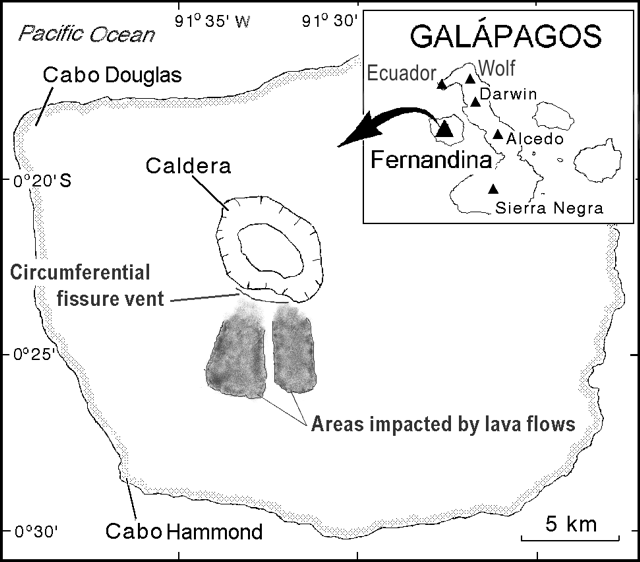
Fernandina (Ecuador)
Lava flows down S flank from circumferential vents near caldera rim
Karthala (Comoros)
16 April 2005 seismicity leading to eruption; near-source tephra 1.5 m thick
Lascar (Chile)
4 May 2005 eruption sends ash over 1,000 km SE, ¾ of the way to Buenos Aires
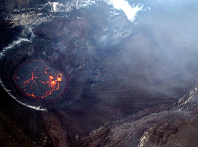
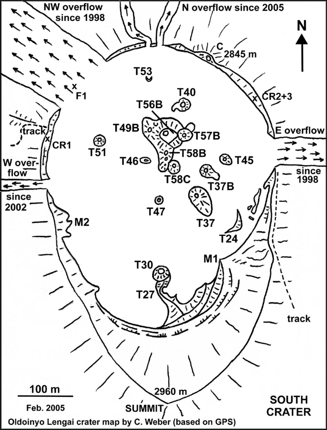
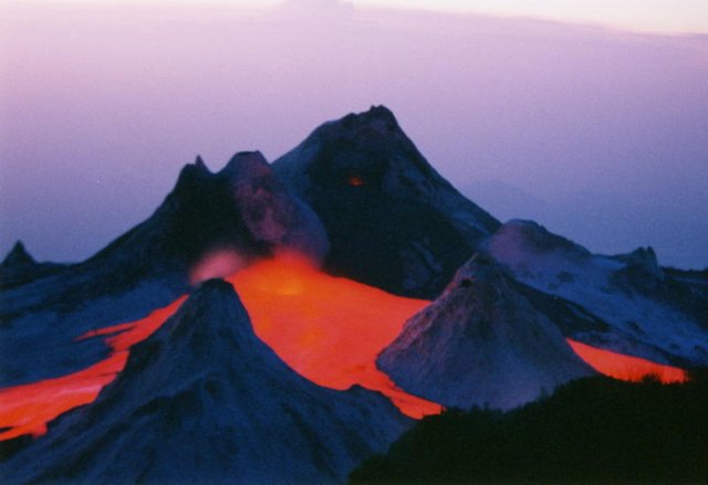
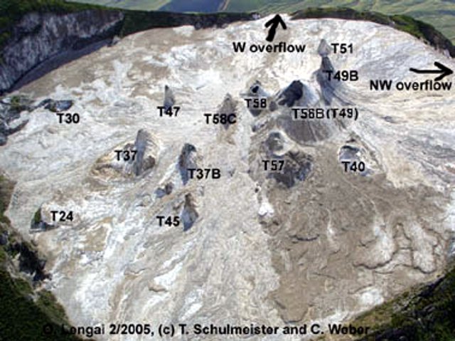
Lengai, Ol Doinyo (Tanzania)
Tall hornito almost reaches summit elevation; more lava spills over rim
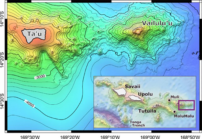
Vailulu'u (United States)
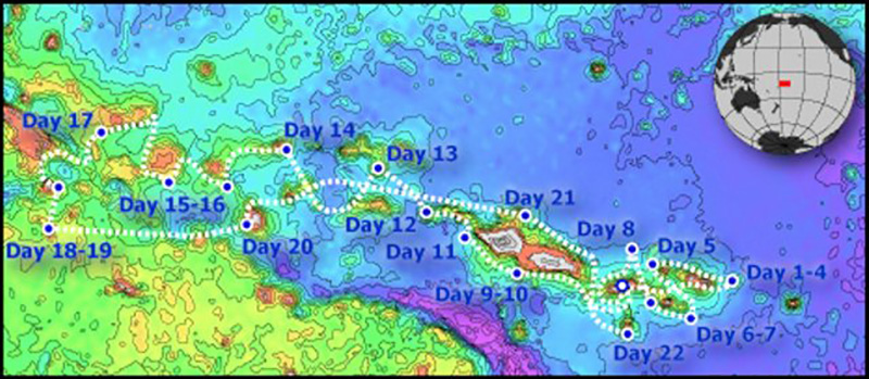
ALIA cruise discloses new cone in the summit crater
Anatahan (United States) — April 2005 Cite this Report
Anatahan
United States
16.35°N, 145.67°E; summit elev. 790 m
All times are local (unless otherwise noted)
Explosive eruption on 6 April 2005 issues highest ash plume recorded here
Anatahan's third historical eruption began on 5 January 2005, and is described in BGVN 29:12. Further details and satellite images were presented in BGVN 30:02, which covered events until mid-February 2005. A 5-6 April 2005 eruption cloud rose to at least 15 km altitude, which was the highest yet seen at the volcano.
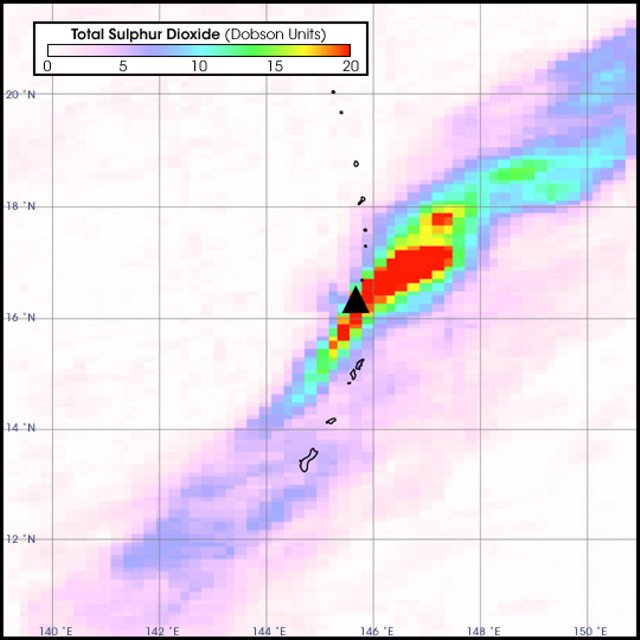
Anatahan erupted almost continuously after 5 January 2005, when it started its third eruption in recorded history. An image collected by the Ozone Monitoring Instrument on NASA's Aura satellite shows atmospheric sulfur dioxide (SO2) concentrations between 31 January and 4 February 2005 (figure 14). A long SO2 plume extends NE and SW of Anatahan, and the edge of the plume covers Guam (the southernmost island) and the other Mariana Islands immediately to Anatahan's N and S.
Volcanogenic SO2 combines with water to create a sulfuric acid haze. Called "vog," this haze can cause illness and make breathing difficult. Volcanic haze grew so thick during the first week of February that the National Weather Service issued a volcanic haze advisory for Guam, where several illnesses were reported.
After mid-February 2005, eruptive activity at Anatahan steadily declined to less than 5% of the peak level attained since the eruption started on 5 January. Ash eruptions continued, and the 2003 crater floor was almost entirely covered by fresh lava out to a diameter of ~ 1 km. A MODIS image taken at 0115 on 18 February showed a plume of steam and vog extending about ~ 170 km SW of Anatahan. Seismic and acoustic records during the last week of February 2005 showed very low levels of activity. Seismic amplitudes during 23-28 February were similar to those recorded prior to the 5 January eruption. NASA MODIS (Moderate Resolution Imaging Spectroradiometer) imagery taken on 28 February showed a faint plume of vog and steam trending W of Anatahan.
During the first two weeks of March 2005 volcanic and seismic activity increased relative to the previous weeks. During 14-17 March, seismicity increased and steam rose a few hundred meters above the volcano. The inner E crater had been nearly filled with lava flows and lapilli since early January.
A small eruption began on 18 March at 1544 according to seismic data. On 19 March the Washington VAAC issued an advisory that an ash plume was visible on satellite imagery below 4 km altitude. Small explosions that began late on 20 March lasted for 14 hours. No emissions were visible on satellite imagery, but others were, later in March and April.
A strong outburst apparently began on 21 March, a day when seismicity increased significantly. Seismic amplitudes peaked on the 25th and faded out on the 26th. Near the peak on the 25th, the U.S. Air Force Weather Agency (AFWA) detected a hot spot on the island on satellite imagery and reported an ash plume briefly reaching ~ 5.8 km altitude. The plume height soon dropped to below 3 km altitude, and by near midday on the 27th the plume had changed from ash and steam to steam and vog. On the 27th the plume extended ~ 240 km SW.
On 5 April at about 2200 seismic signals began to increase slowly, and the Washington VAAC began to see increased ash on satellite imagery. On 6 April 2005 around 0300 an explosive eruption began and produced an ash plume to an initial height of ~ 15.2 km altitude, the highest in recorded history from the volcano. Seismicity peaked at the same time.
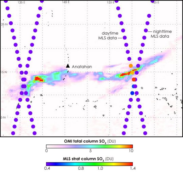
The AFWA reported an upper level ash plume at ~ 15.2 km altitude blowing E to SE and a lower level ash plume at ~ 4.6 km altitude blowing SW; the upper plume extended more than 465 km. Earth Probe TOMS data on 6 April at 1046 showed a compact sulfur-dioxide cloud drifting E of Anatahan following the eruption.
Chuck Sayon, the superintendent of American Memorial Park noted, "On Saipan at around 10 AM the skies darkened and light ash started falling . . . park operation[s] have been restricted to indoor activities due to irritation to eyes and breathing as ash starts to lightly coat the area. Schools are closed as well as the airport until further notice . . .."
On 6 April during 0400 to 0900 the seismicity at Anatahan decreased to near background. The seismicity surged for about 1 hour, with amplitudes about one-half those reached during the earlier eruption, and subsequently dropped again to near background. Prior to the 6 April eruption, during 31 March to 4 April the amplitudes of harmonic tremor varied, reaching a 2-month high on the 3rd. Small explosions occurred every one minute to several minutes, probably associated with cinder-cone formation. Steam-and-ash plumes drifted ~ 200 km, and vog drifted ~ 400 km at altitudes below ~ 2.4- 4.6 km.
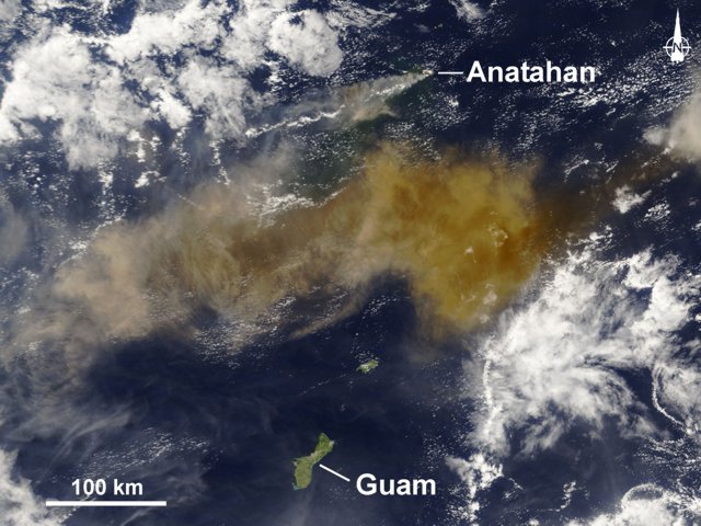
The U.S. Geological Survey (USGS) (in conjunction with the Commonwealth of the Northern Mariana Islands) stated that the "eruption of 6 April 2005 was the largest historical eruption of Anatahan and expelled roughly 50 million cubic meters of ash. The eruption column and the amplitude of harmonic tremor both grew slowly over about 5 hours and both peaked about 0300 on 6 April local time . . .. The peak of the eruption lasted about one hour and then the activity declined rapidly over the following hour."
The 6 April 2005 eruption's plume was captured on satellite images. The image showed a plume that was tan or brown in color and clearly ash laden (figure 15).
Figure 16 shows SO2 concentrations in the atmosphere on 7 April 2005, over 30 hours after the large 6 April eruption. SO2 emissions from the eruption were measured by the Ozone Monitoring Instrument (OMI) on NASA's EOS/Aura satellite. OMI detects the total column amount of SO2 between the sensor and the Earth's surface and maps this quantity as it orbits the planet. A new perspective on the vertical distribution of the SO2 is revealed by combining the OMI data with coincident measurements made by the Microwave Limb Sounder (MLS), also part of the Aura mission.
The MLS data crisscross the OMI image and clearly show that some, but not all, of the SO2 measured by OMI to the volcano's E was in the upper troposphere or above. At these altitudes, SO2—and the sulfate aerosols that form from it—can stay in the atmosphere and affect the climate for a longer period of time. A weaker SO2 signal was also measured in the same region during the nighttime MLS overpass, which crosses the image from upper right to lower left. The daytime data, running from upper left to lower right, coincide with the OMI measurements. The MLS data west of Anatahan show no significant SO2 signal, indicating that the SO2 measured by OMI in this region was in the lower troposphere.
MLS measures thermal emissions from the Earth's limb, so unlike the OMI sensor it also collects data at night. It is designed to measure vertical profiles of atmospheric gases that are important for studying the Earth's ozone layer, climate, and air quality, such as SO2. These images, derived from preliminary, unvalidated OMI and MLS data, show MLS SO2 columns (filled circles) measured every 165 km along the Aura orbit, plotted over the OMI SO2 map. The MLS SO2 columns shown here are derived from profile measurements made from the upper troposphere into the stratosphere (~ 215-0 hPa (hectoPascal, 102 Pa) or ~ 12 km altitude and above), and the circles do not represent the actual size of the MLS footprint, which is roughly 165 x 6 km.
Anatahan's morphological changes were highlighted in before (pre-eruption) versus after (post-eruption) images (figure 17). Seismicity decreased at Anatahan after 6 April and during 7-11 April was at very low levels, near background. On 11 April, a steam-and-ash plume rose ~ 2.7 km altitude and drifted ~ 280 km WSW.
Occasional data from Anatahan revealed that seismicity appeared to increase during 24-25 April. During 20-25 April, a continuous thin plume of ash-and-steam rose to less than ~ 3 km altitude and drifted more than 185 km from the volcano. Harmonic tremor dropped dramatically on 1 May after being at high levels for several days. During 27 April to 1 May, the main ash-and-steam plume rose to ~ 3 km altitude According to a news article, the volcanic plume from Anatahan reached Philippine airspace on 4 May.
On 5 May an extensive ash-and-steam plume to 4.5 km altitude was visible in all directions. Ash extended 770 km N, 130 km S (to northern Saipan), and 110 km W. Vog extended in a broad swath from 3,000 km W, over the Philippines, to 1,000 km N of Anatahan. By 9 May harmonic tremor amplitude had decreased to near-background levels, with a corresponding drop in eruptive activity. As of 10 May AFWA was reporting ash to about 3 km altitude extending 400 km W and an area of vog less than half that noted on 5 May.
On 11 May AFWA reported thick ash rising to 4.2 km altitude and moving WNW. The thick ash extended in a triangular shape from the summit 444 km to the WSW through 510 km to the NW. A layer of thin ash at 3 km altitude extended another 1,000 km beyond the thick ash. A broad swath of vog extended over 2,200 km W nearly to the Philippines and over 1,400 km NNW of Anatahan. Although the ash plume diminished over the next few days and was not as thick, it remained significant, rising to 2.4 km and extending 370 km WNW on the 13th. Scientific personnel from the Emergency Management Office and the USGS working the next day at a spot 2-3 km W of the active vent heard a continuous roaring sound. They also saw ash and steam rising by pure convection, not explosively, to 3 km altitude.
Reference. Chadwick, W.W., Embley, R.W., Johnson, P.D., Merlea, S.G., Ristaub, S., and Bobbitta, A., 2005, The submarine flanks of Anatahan volcano, Commonwealth of the Northern Mariana Islands: Jour. of Volcanology and Geothermal Res. (In press, June 2005).
Geologic Background. The elongate, 9-km-long island of Anatahan in the central Mariana Islands consists of a large stratovolcano with a 2.3 x 5 km compound summit caldera. The larger western portion of the caldera is 2.3 x 3 km wide, and its western rim forms the island's high point. Ponded lava flows overlain by pyroclastic deposits fill the floor of the western caldera, whose SW side is cut by a fresh-looking smaller crater. The 2-km-wide eastern portion of the caldera contained a steep-walled inner crater whose floor prior to the 2003 eruption was only 68 m above sea level. A submarine cone, named NE Anatahan, rises to within 460 m of the sea surface on the NE flank, and numerous other submarine vents are found on the NE-to-SE flanks. Sparseness of vegetation on the most recent lava flows had indicated that they were of Holocene age, but the first historical eruption did not occur until May 2003, when a large explosive eruption took place forming a new crater inside the eastern caldera.
Information Contacts: Juan Takai Camacho and Ramon Chong, Emergency Management Office of the Commonwealth of the Northern Mariana Islands (CNMI/EMO), PO Box 100007, Saipan, MP 96950, USA (URL: http://www.cnmihsem.gov.mp/); Simon Carn, Joint Center for Earth Systems Technology (JCET), University of Maryland Baltimore County (UMBC), 1000 Hilltop Circle, Baltimore, MD 21250, USA; Hawaiian Volcano Observatory (HVO), U.S. Geological Survey, PO Box 51, Hawaii National Park, HI 96718, USA (URL: https://volcanoes.usgs.gov/observatories/hvo/); Charles Holliday, U.S. Air Force Weather Agency (AFWA), Offutt Air Force Base, Nebraska 68113, USA; Randy White and Frank Trusdell, U.S. Geological Survey, 345 Middlefield Road, Menlo Park, CA 94025-3591 USA (URL: https://volcanoes.usgs.gov/nmi/activity/); Saipan Tribune, PMB 34, Box 10001, Saipan, MP 96950, USA (URL: http://www.saipantribune.com/); Operational Significant Event Imagery (OSEI) team, World Weather Bldg., 5200 Auth Rd Rm 510 (E/SP 22), NOAA/NESDIS, Camp Springs, MD 20748, USA (URL: https://www.nnvl.noaa.gov/); Washington Volcanic Ash Advisory Center (VAAC), Satellite Analysis Branch, NOAA/NESDIS E/SP23, NOAA Science Center Room 401, 5200 Auth Road, Camp Springs, MD 20746, USA (URL: http://www.ssd.noaa.gov/); Chuck Sayon, American Memorial Park, Saipan, MP 96950, USA; NASA Earth Observatory (URL: http://earthobservatory.nasa.gov/).
Awu
Indonesia
3.689°N, 125.447°E; summit elev. 1318 m
All times are local (unless otherwise noted)
Stable during mid- to late August 2004
Awu's eruption on 6 June 2004 and its elevated seismicity in early August 2004 was previously reported (BGVN 29:10). This report covers the last half of August 2004, which had not been reported on previously. Since the 6 June eruption, observation of the summit failed to reveal any significant changes (table 3). The hazard status of Awu during this August report remained at Level 2, having been elevated to 4 (the highest on a scale of 1 to 4) at the time of the 6 June eruption and then lowered on 14 June.
Table 3. Seismicity at Awu during August 2004 as reported by DVGHM.
| Date |
Deep Volcanic (A-type) |
Shallow Volcanic (B-type) |
Tectonic |
| 09 Aug-15 Aug 2004 |
-- |
-- |
75 |
| 16 Aug-22 Aug 2004 |
2 |
1 |
81 |
| 23 Aug-29 Aug 2004 |
2 |
-- |
102 |
Geologic Background. The massive Gunung Awu stratovolcano occupies the northern end of Great Sangihe Island, the largest of the Sangihe arc. Deep valleys that form passageways for lahars dissect the flanks of the volcano, which was constructed within a 4.5-km-wide caldera. Powerful explosive eruptions in 1711, 1812, 1856, 1892, and 1966 produced devastating pyroclastic flows and lahars that caused more than 8000 cumulative fatalities. Awu contained a summit crater lake that was 1 km wide and 172 m deep in 1922, but was largely ejected during the 1966 eruption.
Information Contacts: Dali Ahmad, Directorate of Volcanology and Geological Hazard Mitigation (DVGHM), Jalan Diponegoro 57, Bandung 40122, Indonesia (URL: http://www.vsi.esdm.go.id/).
Fernandina (Ecuador) — April 2005 Cite this Report
Fernandina
Ecuador
0.37°S, 91.55°W; summit elev. 1476 m
All times are local (unless otherwise noted)
Lava flows down S flank from circumferential vents near caldera rim
On the morning of 13 May 2005, a new eruption started on uninhabited Fernandina volcano (figure 5). Fernandina last erupted in 1995 (figure 6), and had been quiet and seemingly unchanged when a team from the Ecuadorian Institute of Geophysics (IG) flew over it in late March 2005. On 11 May an M 5.0 earthquake occurred with an epicenter ~ 30 km E of Fernandina's center. Only two other earthquakes have been located by the U.S. Geological Survey (USGS) within 100 km of Fernandina in last 4.5 years (M 4.0 on 23 February 2005 and M 4.6 on 16 April 2005), both having epicenters ~ 70-80 km SE of Fernandina's center. A seismic station, installed by the IG in 1996 on the NE coast of the island, was out of service at the time of eruption.
Galápagos National Park workers in western Galápagos were apparently the first to witness the eruption, and IG technicians recognized it on satellite imagery. The University of Hawaii presents hotspot images on their website. Their GOES data lacked hotspots at 0930, but a clear and strong one had developed on the S flank by 0945. Francisco Dousdebes (of Metropolitan Touring) placed the eruption's start time at 0935. S-flank hotspots were comparatively extensive by 1015. The Washington VAAC issued their first full advisory at 1315. Their notices reported that the W-directed plume rose to ~ 5 km altitude, and the S-directed plume went to 9 km; both were visible as late as 1745 on 13 May, depicting the leading portions of Fernandina' s ash plume more than 200 km from the volcano
An overflight of the eruption on the 13th by the National Park resulted in a report by Patricio Ramón and Hugo Yepes, and the eruption was confirmed by Washington Tapia, director of the Galápagos National Park. That evening, Galápagos resident Greg Estes telephoned Dennis Geist to report that the eruptive source was a "circumferential vent near [the] summit, S side . . . 6 km long with an eruptive zone 50 m across." It was uncertain how this fissure was related to the 1981 eruption site (figure 2 and SEAN 09:03). IG also noted that tephra had fallen on neighboring Isabela Island, in the areas of the volcanoes Wolf and Ecuador (~ 40 km from the vent, figure 1).
At 0537 on the second morning, 14 May, the Washington VAAC reported low level ash/steam not visible in infrared imagery, but at 0746, 1½ hours after sunrise, a plume of ash extended ~ 130 km to the W and was moving at 18 km/hour at 1,800 m elevation. The GOES thermal anomaly was greatly diminished by 0930, and remained low to non-existent until resumption around 1415. That afternoon, an overflight by Godfrey Merlen, Wacho Tapia, and Alan Tye (Charles Darwin Research Station) resulted in the fullest report to date.
They said that although the vent area was obscured by clouds, topography suggested a 4.5 km long fissure vent near the S rim, with activity having progressed from SW (near the first and uppermost flows of the 1995 radial fissure eruption) to the E (figure 1). The lava flows "had begun to pond on the gentler outer skirt of the island," and were then 5.5 km from the coast (~ 5 km from the vents). They thought it unlikely that the flows would reach the sea. A follow-up news report in El Comercio (Quito) quoted Tapia as identifying five flows down the S flank. Only one remained incandescent. At 1745 on 14 May, Washington VAAC reported a plume remaining to the NW, but—lacking detectable ash—they discontinued advisories. Thermal anomalies on the GOES satellite remained strong, however, until the next morning.
The report also noted that, "As on previous eruptions, such as that on Cerro Azul in 1998, lava passing through vegetated areas has caused small fires, but these have not spread far from the lava tongues themselves before going out. Most of the new flows have passed over unvegetated older lava, and damage to Fernandina's vegetation is limited."
The team also flew over Alcedo volcano on Isabela, where Project Isabela staff had reported increased fumarole activity. Steam was rising from the "new" fumarole sites (active since the 1990s) and from the area of sulfur deposits and fumaroles in the southwestern area of the rim, but this activity did not appear unusual.
On 15 May, the GOES thermal anomaly was gone before noon, but returned near midnight (about 2330), over a smaller area, and it remained through sunrise (0615) on 16 May. Small anomalies were visible the next several nights (when contrast with adjacent cold flows was strongest), but there was no obvious evidence of continued feeding of the new flows.
The complex thermal anomalies detected in MODIS satellite imagery (provided by the University of Hawaii), were abundant around the time of eruption. They spread over Fernandina's rim, in some cases in the caldera, and broadly over the S flank. They continued through at least the rest of May.
The Washington VAAC reported that a weak hotspot started 29 May 2005 at 1945 (30 May at 0145 UTC) and a very short narrow plume of ash and gases appeared in multi-spectral imagery at 2145 (30 May at 0345 UTC). No ground confirmation of an eruption was available, and there was a layer of low-level weather cloud over the island. At that time, the plume appeared to dissipate as it moved away at ~ 18 km/hour.
Geologic Background. Fernandina, the most active of Galápagos volcanoes and the one closest to the Galápagos mantle plume, is a basaltic shield volcano with a deep 5 x 6.5 km summit caldera. The volcano displays the classic "overturned soup bowl" profile of Galápagos shield volcanoes. Its caldera is elongated in a NW-SE direction and formed during several episodes of collapse. Circumferential fissures surround the caldera and were instrumental in growth of the volcano. Reporting has been poor in this uninhabited western end of the archipelago, and even a 1981 eruption was not witnessed at the time. In 1968 the caldera floor dropped 350 m following a major explosive eruption. Subsequent eruptions, mostly from vents located on or near the caldera boundary faults, have produced lava flows inside the caldera as well as those in 1995 that reached the coast from a SW-flank vent. Collapse of a nearly 1 km3 section of the east caldera wall during an eruption in 1988 produced a debris-avalanche deposit that covered much of the caldera floor and absorbed the caldera lake.
Information Contacts: Patricio Ramón and Hugo Yepes, Geophysical Institute (IG), Escuela Politécnica Nacional, Apartado 17-01-2759, Quito, Ecuador (URL: http://www.igepn.edu.ec/); Alan Tye, Charles Darwin Research Station, Puerto Ayora, Santa Cruz, Galapagos Islands, Ecuador (URL: http://www.darwinfoundation.org/); Washington Volcanic Ash Advisory Center (VAAC), Satellite Analysis Branch, NOAA/NESDIS E/SP23, NOAA Science Center Room 401, 5200 Auth Road, Camp Springs, MD 20746, USA (URL: http://www.ssd.noaa.gov/); Tom Simkin, Dept. of Mineral Sciences, National Museum of Natural History, Smithsonian Institution, Washington, DC 20013-7012, USA; National Earthquake Information Center, U.S. Geological Survey, Box 25046, DFC, MS 966, Denver, CO 80225-0046, USA (URL: https://earthquake.usgs.gov/); MODIS Thermal Alert System; University of Hawaii and Manoa, 168 East-West Road, Post 602, Honolulu, HI 96822, USA (URL: http://modis.higp.hawaii.edu).
Karthala
Comoros
11.75°S, 43.38°E; summit elev. 2361 m
All times are local (unless otherwise noted)
16 April 2005 seismicity leading to eruption; near-source tephra 1.5 m thick
After a long period of quiescence following the 1991 phreatic eruption, Karthala's seismicity rebounded starting in July 2000 (BGVN 25:10). In October 2000, more than 20 seismic events per day were recorded.
The local observatory and a key source for this report is the Karthala Volcano Observatory (KVO; Netter and Cheminée, 1997). They maintain close ties with the Centre National de Documentation et de Recherche Scientifique des Comores (CNDRS), Reunion Island University, the Institut de Physique du Globe de Paris, Piton de la Fournaise Volcanological Observatory, and various universities in France.
Activity during October 2000-March 2004. Between October 2000 and January 2003, relatively low seismicity was detected beneath Karthala's summit. The seismicity slowly increased. During January instruments recorded 51 earthquakes on the 5th, 58 on the 10th, and 50 on the 11th. During the month of April 2003 instruments registered 732 (i.e. averaging ~ 24 each day).
Seismic instruments detected several short earthquake swarms, each comprised of ~ 150 earthquakes. These swarms took place on 25 March and in April 2003, and each lasted several hours. Moreover, seismologists witnessed another swarm consisting of 183 events on 15 May. Except for that latter swarm, Karthala's seismicity was relatively quiet for 35 days after the 25 April swarm. A photo of the Chahalé crater from the year 2003, well before the April 2005 eruption, appears in figure 6. (For a map of Karthala's summit, see BGVN 16:08.)
During the time interval from early June 2003 to January 2004 instruments registered three periods with elevated seismicity. The first interval spanned 121 days from June until the end of September 2003 and included 6,315 earthquakes. Within that interval there was a major crisis on 6th September, comprised of 345 events, some being felt by local residents (BGVN 28:08).
The second interval began on 11 October 2003, reaching its peak on 4 January 2004 (253 events) and stopped on 31 January 2004. During this interval of 113 days, instruments registered 4,431 earthquakes. The third interval, during the time period of 3 February to 5 March 2004, contained fewer earthquakes. Instruments recorded 832 events in 31 days with a maximum of 143 events per day. After the third interval, KVO recorded only low seismicity until early 2005, when daily events rose to 50-60.
Eruption during April 2005. A seismic crisis began at 0812 on 16 April. Although instruments initially received only short-period events, starting at 0914 they also registered many long-period ones. From 1055 on 16 April a continuous signal was recorded, which was interpreted as tremor marking the beginning of the eruption. At around 1400 that day inhabitants heard a rumbling coming from the volcano. A few minutes later they observed an ash column above the summit. The first ash-fall deposits began to form around 1600, developing on the island's eastern side. According to the firsts reports, ash deposition increased and continued through the night accompanied by a strong smell of sulfur.
On the morning of 17 April ash falls continued on the eastern part of the island and were heavy enough to require inhabitants to use umbrellas to get about. At midday, Jean-Marc Heintz, a pilot for Comores Aviation, flew over the west flank and observed a large plume in the direction of the Chahalé crater. He also clearly observed airborne molten ejecta.
Around 1300, observers saw a very dark plume, spreading into a mushroom shape and accompanied by lightning flashes. Some inhabitants panicked and fled the island's eastern villages. In the afternoon, residents heard rumbling. During the evening, significant rainfall generated small mudflows, and the rumbling became stronger.
At that time, authorities evacuated some eastern villages (according to Agence France Presse (AFP) this affected ~ 10,000 people). Ash there started to fall on the island's western and northern parts, notably, on the country's capital city of Moroni (~ 10 km NW of the summit) and on the Hahaya airport (~ 20 km N of Moroni, ~ 25 km NW of the summit). Figure 7 shows a photo with the base of a vigorous plume over the E flanks on the afternoon of 17 April.
KVO authorities sometimes witnessed a red color at the plume's base, interpreted as a sign of an ongoing magmatic eruption. At 2105 the KVO seismic network recorded a drastic decrease in the amplitude of the tremor. During the night of 17-18 April, wide variations of the tremor amplitude were recorded with a maximum at 0140 on 18 April and a minimum at 0430 on 18 April. Thereafter, the tremor amplitude did not increase. During the night of 17-18 April the plume and falling ash disappeared.
On an overflight of the Chahalé crater at 0830 on 18 April, KVO personnel observed major modifications at the summit (figures 8-10). A lava lake (figure 8) had replaced the water-bearing lake (figure 6) that had occupied the crater since 1991.
On 19 April a new overflight revealed the crater floor containing the lava lake, with its chilled surface emitting steam (figure 13). Lava remained confined to Chahalé crater. Around the caldera area, and particularly on its N, observers saw conspicuous tephra deposits; most of the vegetation had been destroyed (figure 14).
On 20 April a field excursion found that ash deposits varied in thickness from a few millimeters on the coast to ~ 1.5 m at the summit. Near the summit the observers recognized some post-eruptive evaporation and geothermal processes. Specifically, although the lava lake's surface had frozen, there remained sufficient heat under the surface that groundwater migrating towards to the crater's floor evaporated into steam. During another field survey on 8 May, observers noted the renewed presence of lake water inside the crater.
Reference. Netter, C., and Cheminée, J. (eds.), 1997, Directory of Volcano Observatories, 1996-1997: World Organization of Volcano Observatories (WOVO), WOVO/IAVCEI/UNESCO, Paris, 268 p.
Geologic Background. The southernmost and largest of the two shield volcanoes forming Grand Comore Island (also known as Ngazidja Island), Karthala contains a 3 x 4 km summit caldera generated by repeated collapse. Elongated rift zones extend to the NNW and SE from the summit of the Hawaiian-style basaltic shield, which has an asymmetrical profile that is steeper to the S. The lower SE rift zone forms the Massif du Badjini, a peninsula at the SE tip of the island. Historical eruptions have modified the morphology of the compound, irregular summit caldera. More than twenty eruptions have been recorded since the 19th century from the summit caldera and vents on the N and S flanks. Many lava flows have reached the sea on both sides of the island. An 1860 lava flow from the summit caldera traveled ~13 km to the NW, reaching the W coast to the N of the capital city of Moroni.
Information Contacts: Nicolas Villeneuve (CREGUR, Centre de Recherches et d'Etudes en Géographie de l'Université de la Réunion); Hamidou Nassor, and Patrick Bachèlery (LSTUR, Laboratoire des Sciences de la Terre), Université de La Réunion BP 7151, 15 Avenue, René Cassin, 97715 Saint-Denis, Reunion Island; François Sauvestre and Hamid Soulé, CNDRS, BP 169, Moroni, République Fédérale Islamique des Comores (URL: http://volcano.ipgp.jussieu.fr/karthala/stationkar.html).
Lascar
Chile
23.37°S, 67.73°W; summit elev. 5592 m
All times are local (unless otherwise noted)
4 May 2005 eruption sends ash over 1,000 km SE, ¾ of the way to Buenos Aires
Lascar, the most active volcano in northern Chile, erupted on 4 May 2005. Although the eruption was substantial, thus far there is an absence of reports from anyone who saw the eruption at close range. Preliminary assessments came mainly from satellite sensors and distant affects witnessed in Argentina. This report is based on one sent to us by Chilean Observatorio Volcanológico de los Andes del Sur (OVDAS) scientists José Antonio Naranjo and Hugo Moreno, discussing events around 4 May, with brief comments on some of Lascar's behavior in the past several years, and suggestions for future monitoring.
Lascar sits ~ 70 km SW of the intersection between Chile, Argentina, and Bolivia, ~ 300 km inland from the Chilean port city of Antofagasta. This part of the coast lies along the Atacama desert, and on flat terrain tens of kilometers W of Lascar resides a large salt pan, the Salar de Atacama (about 50 x 150 km). The settlement of Toconao is ~ 33 km NW of Lascar. Previous reports discussed field observations during 13 October 2002 to 15 January 2003, and fine ash discharged from fumaroles on 9 December 2003 (BGVN 28:03 and 29:01).
Naranjo and Moreno concluded that at roughly 0400 on 4 May an explosive eruption ejected an ash cloud to a tentative altitude on the order of 10 km that dispersed to the SE. About 2 hours later the cloud began dropping ash on Salta, Argentina. Satellite images portrayed the ash cloud's dispersal. An aviation 'red alert' was issued by the Buenos Aires Volcanic Ash Center; they saw the plume over Argentina at altitudes of 3-5 km.
Shortly after atmospheric impacts of the 4 May eruption became apparent, the Buenos Aires VAAC notified OVDAS that NW Argentine cities had reported falling ash. These cities, all SE of Lascar, included Jujuy, Salta, Santiago del Estero, and Santa Fe—locations with respective approximate distances from Lascar of 260, 275, 580, and 1,130 km. The Argentine province of Chaco, along the country's NE margin, was also noted as receiving ash. Buenos Aires (~ 1,530 km SE of Lascar) remained ~ 400 km beyond the point of the farthest detected ashfall.
Patricia Lobera, a professor in Talabre, Argentina, 17 km E of Lascar, said that eruption noises were not heard there on the morning of 4 May. When observers saw the plume from Talabre that morning they reportedly thought the plume looked similar to those on previous days.
Remotely sensed hot spots were detected on a GOES satellite image for 0339 (0639 UTC) on 4 May, showing the first evidence of an eruption. In a later image, at 0409, the thermal anomaly had increased, and the image suggested a growing, ash-bearing cloud then trending ~ 23 km to the SE. The thermal anomaly diminished in intensity by 0439, remaining diminished thereafter, but by that time the plume's leading margin extended over ~ 100 km SE and its tail had detached from the volcano. At 0509 the plume reached 170 km SE. According to a press report, at around 0600 ash fell in Salta (~ 275 km SE of Lascar).
Rosa Marquilla, a geologist at the University of Salta, reported that residents there noticed a mist attributed to the eruption, which hung over the city until at least to 1600, after which, the sky gradually cleared. Preliminary description of the petrography of the ash that fell in Salta came from Ricardo Pereyra (University of Salta) who saw crystal fragments (pyroxenes, feldspars, and magnetite) and fragments of volcanic glass containing plagioclase mircrolites. Lithic fragments were not observed.
The OVDAS authors concluded that, apparently since the year 2000, Lascar underwent constant degassing from an open vent within the ~ 780-m-diameter active central crater. Sporadic explosions as in July 2000 and October 2002, and in this case, 4 May 2005, could be due to diverse causes. For example, there may have been temporarily obstructed conduits at depth, local collapses blocking the vent at the crater floor, or fresh magma injection contacting groundwater. Extrusion of a viscous dome lava also might explain the sudden explosions. That circumstance would presumably lead to visibly increased fumarolic output.
Naranjo and Moreno had several suggestions for ongoing monitoring. First, they suggested developing closer long-term contacts, including people able to visually monitor the volcano directly, as well as continued systematic contact with the Buenos Aires VAAC and their satellite analysts. They recommended ongoing relations with the University of Hawaii (MODVOLC) program to remotely sense hot-spots. They went on to suggest a campaign of stereo aerial photography to detect changes in the active crater. They advocated notifying local inhabitants of the possibility of ash falls before another explosive episode. They pointed out that mountaineers should be made aware of elevated risks within 8 km of the active crater.
References. Gardeweg, M., 1989, Informe preliminar sobre la evolución de la erupción del volcán Láscar (II Región): noviembre 1989: Servicio Nacional de Geología y Minería, Informe Inédito (unpublished report), 27 p.
Gardeweg, M., and Lindsay, J., 2004, Lascar Volcano, La Pacana Caldera, and El Tatio Geothermal Field: IAVCEI General Assembly Pucón 2004, Field Trip Guide-A2, 32 p.
Gardeweg, M., Medina, E., Murillo, M., and Espinoza, A., 1993, La erupción del 19-20 de abril de 1993: VI informe sobre el comportamiento del volcán Láscar (II Región): Servicio Nacional de Geología y Minería, Informe Inédito (unpublished report), 20 p.
Geologic Background. Láscar is the most active volcano of the northern Chilean Andes. The andesitic-to-dacitic stratovolcano contains six overlapping summit craters. Prominent lava flows descend its NW flanks. An older, higher stratovolcano 5 km E, Volcán Aguas Calientes, displays a well-developed summit crater and a probable Holocene lava flow near its summit (de Silva and Francis, 1991). Láscar consists of two major edifices; activity began at the eastern volcano and then shifted to the western cone. The largest eruption took place about 26,500 years ago, and following the eruption of the Tumbres scoria flow about 9000 years ago, activity shifted back to the eastern edifice, where three overlapping craters were formed. Frequent small-to-moderate explosive eruptions have been recorded since the mid-19th century, along with periodic larger eruptions that produced ashfall hundreds of kilometers away. The largest historical eruption took place in 1993, producing pyroclastic flows to 8.5 km NW of the summit and ashfall in Buenos Aires.
Information Contacts: José Antonio Naranjo and Hugo Moreno, Programa Riesgo Volcanico, Servicio Nacional de Geologia y Mineria, Avda. Santa Maria 0104, Casilla 1347, Santiago, Chile; Gustavo Alberto Flowers, Buenos Aires Volcanic Ash Advisory Center (Buenos Aires VAAC), Servicio Meteorológico Nacional-Fuerza Aérea Argentina, 25 de mayo 658, Buenos Aires, Argentina (URL: http://www.smn.gov.ar/vaac/buenosaires/productos.php).
Ol Doinyo Lengai (Tanzania) — April 2005 Cite this Report
Ol Doinyo Lengai
Tanzania
2.764°S, 35.914°E; summit elev. 2962 m
All times are local (unless otherwise noted)
Tall hornito almost reaches summit elevation; more lava spills over rim
Although lava venting at Ol Doinyo Lengai continued intermittently after February 2004 (BGVN 29:02), no significant changes were detected until July 2004, a time when vigorous venting emitted substantial amounts of the low-viscosity carbonatitic lava typical at this volcano ('flash floods' of lava). This summary report covers the time interval from February 2004 through early February 2005 based on observations made by Frederick Belton, Celia Nyamweru, Bernhard Donth, and Christoph Weber. Websites devoted to Ol Doinyo Lengai, including photographs, information on the evolution, recent history, and current status of the volcano are maintained by Belton, Nyamweru, and Weber.
A map, thermal data, and some new elevation estimates. In February 2005 Weber and others collected location data with a global positioning system (GPS) receiver. Weber used this to create a sketch map of the active crater (figure 82).
In July 2004 Belton completed the third of a series of distance measurements across crater outflow areas at the crater rim (table 7). Due to the unusually strong eruption on 15 July 2004 (figure 83), deposits comprising the E overflow widened by 3 or 4 m (growing from 44 to 47 m, figure 82). Later, in January 2005, observers noticed a fourth area of overflows had become established on the N crater rim, with lavas pouring over the rim at two adjacent points there (figure 82).
Table 7. For Ol Doinyo Lengai, the width of the three extant lava outflows at the points where they spilled from the active crater ('overflows,' figure 15), as measured during 2 August 2003-29 July 2004. Two additional small overflows formed later, by January 2005, on the N crater rim. The 3-m E-overflow increase occurred during the eruption of T58C on 15 July 2004. Courtesy of Frederick Belton.
| Date |
NW overflow width |
E overflow width |
W overflow width |
| 02 Aug 2003 |
135 m |
44 m |
17 m |
| 29 Jun 2004 |
135 m |
44 m |
18 m |
| 29 Jul 2004 |
135 m |
47 m |
18 m |
During 3-7 February 2005 Weber and others completed a series of lava and fumarole temperature measurements that appear as tables 8 and 9. The tables indicate the hottest lava and fumarole temperatures at cracks were 588°C (at T49C, February 2004) and 150°C (at T49G, June 2004), respectively. The hornitos T49C and T49G both lie near T49B, a hornito delineated on figure 82.
Table 8. Repeated maximum lava temperatures measured at Ol Doinyo Lengai during 28 August 1999 to 3 February 2005. The measurements were made employing a digital thermometer (TM 914C with a stab feeler of standard K type). The instrument was used in the 0-1200°C mode, and at least four replicate measurements were made at any one spot. Calibration was by the delta-T method; uncertainties were ± 6°C in the 0-750°C range. Courtesy of C. Weber.
| Date |
Location |
Temperature (°C) |
| 28 Aug 1999 |
T40 lava lake |
529 |
| 01 Sep 1999 |
Pahoehoe flow in a tube near T40 |
519 |
| 01 Sep 1999 |
Aa flow still in motion at flat terrains (60 cm thick) |
516 |
| 03 Oct 2000 |
Pahoehoe flow in a tube near T49B |
507 |
| 03 Oct 2000 |
Aa flow still in slow motion at flat terrain (25 cm thick) |
496 |
| 11 Feb 2004 |
Pahoehoe flow in a tube near T49G |
588 |
| 12 Feb 2004 |
Pahoehoe flow in a tube near T49B |
579 |
| 13 Feb 2004 |
Aa flow not in motion anymore at flat terrain (15 cm thick) |
490 |
| 26 Jun 2004 |
Pahoehoe flow in slow motion (10 cm thick) flat terrain |
560 |
| 03 Feb 2005 |
Pahoehoe flow (15 cm thick) in motion traveling within a levee. |
561 |
| 03 Feb 2005 |
Aa flow not in motion anymore at flat terrain (15 cm thick) |
520 |
Table 9. Maximum fumarole temperatures measured at cracks in Ol Doinyo Lengai's crater floor over a series of visits during 28 August 1999 to 4 February 2005. Collected using the digital thermometer with procedures and parameters noted with the previous table. For locations, see map (figure 15). Courtesy of C. Weber.
| Date |
Location |
Temperature (°C) |
| 28 Aug 1999 |
F1 |
70 |
| 28 Aug 1999 |
Near T49 |
82 |
| 03 Oct 2000 |
Near T49C |
75 |
| 03 Oct 2000 |
F1 |
69 |
| 20 Oct 2002 |
The hottest cracks in the crater floor |
124 |
| 20 Oct 2002 |
F1 |
78 |
| 30 Jun 2003 |
F1 |
86 |
| 30 Jun 2003 |
Near T49C |
76 |
| 12 Feb 2004 |
F1 |
88 |
| 26 Jun 2004 |
F1 |
78 |
| 26 Jun 2004 |
Near T49C |
150 |
| 04 Feb 2005 |
F1 |
84 |
Weber's team GPS measurements suggested a summit elevation of 2,960 ± 5 m. This is consistent with GPS measurements taken in October 2000, by a scientific group led by Joerg Keller, of 2,950-2,960 m (BGVN 25:12). In addition, the tallest hornito in the N-central crater rises to nearly this elevation (see discussion of T49/T56B, below).
During observations in February 2004, Weber measured the tallest hornito at the T49 location (part of T56B) in the center area of the active crater. GPS readings on top of T56B yielded an elevation of 2,886 m. This is only [74 m below the elevation of the summit]. The top of T49 is also ~ 33 m above the adjacent crater floor to the N. In addition, when he measured on 3-7 February, Weber found hornito T58C (a then recent feature) had grown to reach an elevation of ~ 2,870 m.
Observations during February 2004 to February 2005. During February 2004 visits, T56B did not erupt, but instead a new vent erupted at the T49 location (~ 10 m E of T49B, see also BGVN 29:02). This new vent was called T49G (figure 15).
A group from Volcano Expeditions International (VEI) spent 24-30 June 2004 on Lengai and found much of the scene at the vents in the crater similar to that noted in February 2004. They noted that half of the upper 10 m of hornito T56B had collapsed on its E side, and an active lava lake had formed inside this hornito with lava escaping several times through the collapsed opening to its E and flowing out ~ 200 m. The lava was rich in gas with a temperature of 560°C. The hornito T58B was also active and spattered lava many times during these days of observation. Some lava flows from T58B reached about 150 m to the S.
During 2-3 July 2004, Belton observed T58B erupt repeatedly, emitting lava and strombolian displays. The escaping lava flowed S, passing near the base of hornito T47. On 4 July, Belton saw some of the most intense activity of the month. A sequence of lavas erupted on that day and over the next few days. However, events in mid-July and later were also unusually vigorous.
The 4 July 2004 activity included strong strombolian eruptions at T58B and several collapses of its vent area, which released large cascades of lava onto the crater floor. Simultaneously, a tube-fed eruption of pahoehoe lava from the new vent T49G flowed across the NW crater rim to spill down that flank. Early on 5 July numerous eruptions of T58B sent lava flowing toward T47 at an estimated velocity of 10 m/sec. On 6 July, lava flowed out of the lake in T56B and onto the crater floor moving E and entering a cave in T45 for a short distance.
After very low activity during 7-10 July 2004, renewed flows and spatter came out on 11 July from T58B, and frequent but short (usually ~ 2 minute) episodes of loud degassing and spattering issued from the lava lake in T56B. At night, this vent emitted incandescent gas. This pattern continued until the morning of 14 July, when eruptions at T58B became more explosive and it expelled small ash clouds. On the morning of 15 July a collapse in the vent area of T58B released large rapid lava flows to the E. The episodes of degassing and spattering from T56B increased in frequency until 1500 on 15 July, when a small hole formed in the crater floor just E of T58B.
Called T58C, the hole became a newly opened vent. It began emitting visible gas puffs mixed with spatter. At this time the degassing episodes from T56B ceased. T58C then began strong degassing and squirted up intermittent lava fountains. The fountains soon fed a large lava stream moving toward the S crater wall.
By 1600 on 15 July 2004 a paroxysm at T58C was in progress, with lava forming 10- to 12-m-tall fountains and 'flash floods' that completely inundated the central-eastern crater floor (in the area between T56B, T58B, T37, T37B, T45, and T57). T58C also ejected strong jets of ash and gas. Turbulent rivers of lava flowing at more than 10 m/sec swept toward the crater's S wall and its E overflow and completely surrounded T37B and T45. Flow rate from the vent was estimated to peak at 10 m3/s.
The momentum of the rapidly outflowing lava carried it nearly 3 m up the W (upstream) side of T45 and obliterated the large cave within that cone. The associated surge of lava poured over the E crater rim and down the flank. It flooded over a 3 m wide swath of vegetation. This triggered a huge cloud of steam and smoke that resembled a small pyroclastic flow. The smoke cloud was accompanied by a loud sizzling sound. A brush fire burned along the crater rim overflow as additional floods of lava arrived. These larger-than-normal flows lasted for little more than 30 sec and were separated by periods of repose of 5 to 6 min. After sunset, incandescent gas flared from the vent during the repose periods. Weak strombolian activity was seen in T56B.
Early on 16 July 2004 the newly formed T58C was a circular pit ~ 2 m in diameter with lava sloshing violently at a depth of ~ 2 m. Two small sub-vents on the N and S edges of the pit interconnected with the main vent. Activity continued sporadically at T58B and T56B with strombolian activity and lava flows. On 21 July there was an exceptionally strong eruption of T58B with loud explosions, jetting of ash-poor clouds, and spatter thrown to above-average heights. Explosions blasted a new vent in the upper E side of T58B. At least four oval bombs 9-12 cm in length flew through the air, along with a great deal of lapilli and ash. Later examination of the bomb's interiors revealed that they all had an outer zone ~ 1.5- to 2-cm thick and a distinctive inner core.
On 23 July 2004, a sloping ~ 4 m2 oval section of the crater floor immediately SW of the new spatter cone T58C began to steam and vibrate. Tremor increased and ground movement was visible, manifested as a small section of crater floor rapidly pushed outward and then inward several centimeters, like a membrane vibrating in time to the degassing sounds of lava in T58C just behind it. Abruptly this portion of the crater floor broke outward, and a flood of lava ensued. T58C was observed to grow in height through the time when Belton left the crater on 29 July 2004.
Observations during January and February 2005. Donth reported that during his visit on 10 January 2005, hornito T49B erupted to form many effusive lava flows. For the first time, lava escaped over the northern edge of the crater (see figure 15).
During Weber's crater visit, 3-7 February 2005, the hornito T49B actively emitted lava flows that traveled to the N. Pahoehoe lava flows in motion within small levees on flat terrain were measured from 520°C up to a maximum of 561°C (table 3). The fumaroles at F1 had a maximum temperature of 84°C, and at hornito T46, a maximum of 91°C (table 4). No change in distance was measured across the CR1, CR2, and CR3 cracks cutting the upper crater walls. Adding to visitor safety concerns, which include altitude sickness, burns, falls, and impact from ejecta, Weber's team saw a spitting cobra close to the summit. An overflight by plane on 14 February showed no subsequent change, but did give an excellent view of the crater and its central hornitos (figure 16).
A flight on 14 February failed to reveal subsequent changes. But the effort provided an excellent view of the crater and its central hornitos (figure 84).
Geologic Background. The symmetrical Ol Doinyo Lengai is the only volcano known to have erupted carbonatite tephras and lavas in historical time. The prominent stratovolcano, known to the Maasai as "The Mountain of God," rises abruptly above the broad plain south of Lake Natron in the Gregory Rift Valley. The cone-building stage ended about 15,000 years ago and was followed by periodic ejection of natrocarbonatitic and nephelinite tephra during the Holocene. Historical eruptions have consisted of smaller tephra ejections and emission of numerous natrocarbonatitic lava flows on the floor of the summit crater and occasionally down the upper flanks. The depth and morphology of the northern crater have changed dramatically during the course of historical eruptions, ranging from steep crater walls about 200 m deep in the mid-20th century to shallow platforms mostly filling the crater. Long-term lava effusion in the summit crater beginning in 1983 had by the turn of the century mostly filled the northern crater; by late 1998 lava had begun overflowing the crater rim.
Information Contacts: Christoph Weber, Volcano Expeditions International, Muehlweg 11, 74199 Untergruppenbach, Germany (URL: http://www.v-e-i.de/); Celia Nyamweru, Department of Anthropology, St. Lawrence University, Canton, NY 13617, USA (URL: http://blogs.stlawu.edu/lengai/); Frederick Belton, Developmental Studies Department, PO Box 16, Middle Tennessee State University, Murfreesboro, TN 37132, USA (URL: http://oldoinyolengai.pbworks.com/); Bernard Donth, Waldwiese 5, 66123 Saarbruecken, Germany.
Vailulu'u (United States) — April 2005 Cite this Report
Vailulu'u
United States
14.215°S, 169.058°W; summit elev. -592 m
All times are local (unless otherwise noted)
ALIA cruise discloses new cone in the summit crater
According to Hubert Staudigel (Scripps Institution of Oceanography) and Stanley Hart (Woods Hole Oceanographic Institute), Vailulu'u seamount, the most active Samoan submarine volcano, erupted between April 2001 and April 2005. It formed a 293-m-tall lava cone, which was named Nafanua after the Samoan Goddess of War. This new cone had been growing inside the 2-km-wide caldera of Vailulu'u at a minimum rate of about 20 cm/day since April 2001. Nafanua was discovered during a 2005 diving expedition with the National Oceanic and Atmospheric Agency (NOAA) research submersible Pisces V, launched from the University of Hawaii research vessel Kaimikai O Kanaloa (KOK). It is located in the originally 1,000-m-deep W crater of Vailulu'u (figures 5 to 8).
Seismic monitoring during April-June 2000 showed substantial seismicity, ~ 4 earthquakes per day with hypocenters beneath Nafanua (Konter and others, 2004; BGVN 26:06), which can now be interpreted as pre-eruption seismic activity. These observations are consistent with previous reports highlighting the volcanic and hydrothermal activity of Vailulu'u (Hart and others, 2000; Staudigel and others, 2004). The scientists suggested that continued volcanic activity could bring the summit region of Vailulu'u to a water depth of ~ 200 m. At that point, Nafanua would overtop the crater rim and further growth would require a build-up of the lower flanks, areas that rise from the 5,000-m-deep floor of the ocean.
Staudigel and Hart teamed up in April 2005 on the Hawaiian Research Vessel Kilo Moana to study the Samoan hotspot thought to underlie Vailulu'u. They named their expedition ALIA after the ancient twin-hulled canoe that Samoan warriors used to explore the SW Pacific. The Kilo Moana left Pago Pago on 4 April 2005 to study active and extinct underwater volcanoes along the chain of Samoan islands. The expedition investigated previously uncharted seamounts and the submarine portions of some islands, scattered over almost 600 nautical miles, from its most recent and quite active Vailulu'u submarine volcano in the E to Combe Island in the W.
The Nafanua cone was first mapped by using the center beam of the research vessel KOK in several crossings of the W crater. An active hydrothermal system was apparent from evidence such as the murky water that limited visibility during two submersible dives, several microbial biomats covering pillow lavas that were centimeters thick, and a large number of diffuse vents. A dive on 30 March 2005 to examine Nafanua reported "that it must have grown in the last 4 years because CTD (conductivity-temperature-depth) crossings in 2001 still were consistent with the old crater morphology ... the basal portion of the cone displayed relatively large pillows, and higher up pillows look almost like very fluid pahoehoe that collapsed and/or transitioned into aa flows. Nafanua . . . grew very fast with abundant breccia material from collapsing and draining pillows, in particular in the summit region."
On 1 April, another dive along the outer flanks of Vailulu'u found that during the up-slope transit, observers saw a few additional areas of active venting and many sites where there had been venting in the past. Large and perfectly formed pillow lavas were present in most sites, with a few areas being dominated by broken talus fragments and some having completely black glassy pillows with no oxidation, apparent evidence for relatively recent formation. The topography was extremely rough, the slope being punctuated with numerous fissure systems and edifices of pillow lava.
A primary plan for the ALIA expedition was to study the water in and around the seamount for several days using a CTD probe. To sample the inside of the volcano for a full tidal cycle, the scientists varied the depth of the CTD between 40 and 930 m (almost to the crater floor), collecting various data, including visibility. At Vailulu'u, the particulates given off by hydrothermal venting are flushed out of its caldera during each tidal cycle into the surrounding water. In 2005, a dense layer of particulates was found in the water within the crater, but the water was clear outside the crater rim. This contrasts with observations seen from the cruise in 2000, when there was a dense ring of particulates around the whole volcano. It appears that in 2005 the particulates were rising above the crater and then later sinking, instead of forming the widespread ring observed in 2000.
In addition, the expedition crew conducted dredging of the new summit of Nafanua. Staudigel and Hart noted that the rocks from the first dredge haul were quite newly formed, containing pristine olivine-phyric volcanic rocks. Abundant large vesicles in the rocks from Nafanua suggest a volatile-rich magma capable of submarine lava fountaining and explosive outgassing in shallower water. Dredging from a second site, outside of Vailulu'u, recovered rocks that were both much older and far less fragile.
References. Hart, S.R., Staudigel, H., Koppers, A.A.P., Blusztajn, J., Baker, E.T., Workman, R., Jackson, M., Hauri, E., Kurz, M., Sims, K., Fornari, D., Saal, A., and Lyons, S., 2000, Vailulu'u undersea volcano: The new Samoa: Geochemistry, Geophysics, Geosystems (G3), American Geophysical Union, v. 1, no. 12, doi: 10.1029/2000GC000108.
Konter, J.G., Staudigel, H., Hart, S.R., and Shearer, P.M., 2004, Seafloor seismic monitoring of an active submarine volcano: Local seismicity at Vailulu'u Seamount, Samoa: Geochemistry, Geophysics, Geosystems (G3), American Geophysical Union, v. 5, no. 6, QO6007, doi: 10.1029/2004GC000702.
Lippsett, L., 2002, Voyage to Vailulu'u: Searching for Underwater Volcanoes. Woods Hole Oceanographic Institution, Fathom online magazine (URL: http://www.fathom.com/feature/122477/).
Staudigel, H., Hart, S.R., Koppers, A., Constable, C., Workman, R., Kurz, M., and Baker, E.T., 2004, Hydrothermal venting at Vailulu'u Seamount: The smoking end of the Samoan chain: Geochemistry, Geophysics, Geosystems (G3), American Geophysical Union, v. 5, no. 2, QO2003, doi: 10.1029/2003GC000626.
Geologic Background. Vailulu'u, a massive basaltic seamount discovered in 1975, rises 4,200 m from the sea floor to a depth of 590 m. Located about one-third of the way between Ta'u and Rose islands at the E end of the American Samoas, it is considered to mark the current location of the Samoan hotspot. The summit contains an oval-shaped crater that is 2 km wide and 400 m deep. Two principal rift zones extend E and W from the summit, parallel to the trend of the hotspot; a third rift extends SE. The rift zones and escarpments produced by mass wasting phenomena give the seamount a star-shaped pattern. On 10 July 1973 explosions were recorded by SOFAR (hydrophone records of underwater acoustic signals). An earthquake swarm in 1995 may have been related to an eruption. Eruptive activity between April 2001 and April 2005 formed a cone almost 300 m high, named Nafanua. Repeated bathymetric mapping surveys showed depth changes, including height and width increases of Nafanua after 2005, that suggest at least intermittent activity during 1999-2017; a 2019 survey showed no further changes since 2017.
Information Contacts: Hubert Staudigel, Institute of Geophysics and Planetary Physics, Scripps Institution of Oceanography, Univ. of California, San Diego, La Jolla, CA 92093-0225, USA (URL: https://earthref.org/whoswho/ER/hstaudigel/, https://igpp.ucsd.edu/); Stanley R. Hart, Woods Holes Oceanographic Institute, Geology and Geophysics Dept., Woods Hole, MA 02543, USA; ALIA Expedition, Samoan Seamounts, R/V Kilo Moana (KM0506), supported by the San Diego Supercomputer Center and the Scripps Institution of Oceanography (URL: https://earthref.org/ERESE/projects/ALIA/).