Recently Published Bulletin Reports
Manam (Papua New Guinea) Few ash plumes during November-December 2022
Krakatau (Indonesia) Strombolian activity and ash plumes during November 2022-April 2023
Stromboli (Italy) Strombolian explosions and lava flows continue during January-April 2023
Nishinoshima (Japan) Small ash plumes and fumarolic activity during November 2022 through April 2023
Karangetang (Indonesia) Lava flows, incandescent avalanches, and ash plumes during January-June 2023
Ahyi (United States) Intermittent hydroacoustic signals and discolored plumes during November 2022-June 2023
Kadovar (Papua New Guinea) An ash plume and weak thermal anomaly during May 2023
San Miguel (El Salvador) Small gas-and-ash explosions during March and May 2023
Semisopochnoi (United States) Occasional explosions, ash deposits, and gas-and-steam plumes during December 2022-May 2023
Ebeko (Russia) Continued explosions, ash plumes, and ashfall during October 2022-May 2023
Home Reef (Tonga) Discolored plumes continued during November 2022-April 2023
Ambae (Vanuatu) New lava flow, ash plumes, and sulfur dioxide plumes during February-May 2023
Manam (Papua New Guinea) — July 2023  Cite this Report
Manam
Papua New Guinea
4.08°S, 145.037°E; summit elev. 1807 m
All times are local (unless otherwise noted)
Few ash plumes during November-December 2022
Manam is a 10-km-wide island that consists of two active summit craters: the Main summit crater and the South summit crater and is located 13 km off the northern coast of mainland Papua New Guinea. Frequent mild-to-moderate eruptions have been recorded since 1616. The current eruption period began during June 2014 and has more recently been characterized by intermittent ash plumes and thermal activity (BGVN 47:11). This report updates activity that occurred from November 2022 through May 2023 based on information from the Darwin Volcanic Ash Advisory Center (VAAC) and various satellite data.
Ash plumes were reported during November and December 2022 by the Darwin VAAC. On 7 November an ash plume rose to 2.1 km altitude and drifted NE based on satellite images and weather models. On 14 November an ash plume rose to 2.1 km altitude and drifted W based on RVO webcam images. On 20 November ash plumes rose to 1.8 km altitude and drifted NW. On 26 December an ash plume rose to 3 km altitude and drifted S and SSE.
Intermittent sulfur dioxide plumes were detected using the TROPOMI instrument on the Sentinel-5P satellite, some of which exceeded at least two Dobson Units (DU) and drifted in different directions (figure 93). Occasional low-to-moderate power thermal anomalies were recorded by the MIROVA (Middle InfraRed Observation of Volcanic Activity) system; less than five anomalies were recorded each month during November 2022 through May 2023 (figure 94). Two thermal hotspots were detected by the MODVOLC thermal alerts system on 10 December 2022. On clear weather days, thermal activity was also captured in infrared satellite imagery in both the Main and South summit craters, accompanied by gas-and-steam emissions (figure 95).
Geologic Background. The 10-km-wide island of Manam, lying 13 km off the northern coast of mainland Papua New Guinea, is one of the country's most active volcanoes. Four large radial valleys extend from the unvegetated summit of the conical basaltic-andesitic stratovolcano to its lower flanks. These valleys channel lava flows and pyroclastic avalanches that have sometimes reached the coast. Five small satellitic centers are located near the island's shoreline on the northern, southern, and western sides. Two summit craters are present; both are active, although most observed eruptions have originated from the southern crater, concentrating eruptive products during much of the past century into the SE valley. Frequent eruptions, typically of mild-to-moderate scale, have been recorded since 1616. Occasional larger eruptions have produced pyroclastic flows and lava flows that reached flat-lying coastal areas and entered the sea, sometimes impacting populated areas.
Information Contacts: Rabaul Volcano Observatory (RVO), Geohazards Management Division, Department of Mineral Policy and Geohazards Management (DMPGM), PO Box 3386, Kokopo, East New Britain Province, Papua New Guinea; Darwin Volcanic Ash Advisory Centre (VAAC), Bureau of Meteorology, Northern Territory Regional Office, PO Box 40050, Casuarina, NT 0811, Australia (URL: http://www.bom.gov.au/info/vaac/); MIROVA (Middle InfraRed Observation of Volcanic Activity), a collaborative project between the Universities of Turin and Florence (Italy) supported by the Centre for Volcanic Risk of the Italian Civil Protection Department (URL: http://www.mirovaweb.it/); Hawai'i Institute of Geophysics and Planetology (HIGP) - MODVOLC Thermal Alerts System, School of Ocean and Earth Science and Technology (SOEST), Univ. of Hawai'i, 2525 Correa Road, Honolulu, HI 96822, USA (URL: http://modis.higp.hawaii.edu/); NASA Global Sulfur Dioxide Monitoring Page, Atmospheric Chemistry and Dynamics Laboratory, NASA Goddard Space Flight Center (NASA/GSFC), 8800 Greenbelt Road, Goddard, Maryland, USA (URL: https://so2.gsfc.nasa.gov/); Copernicus Browser, Copernicus Data Space Ecosystem, European Space Agency (URL: https://dataspace.copernicus.eu/browser/).
Krakatau (Indonesia) — July 2023 Cite this Report
Krakatau
Indonesia
6.1009°S, 105.4233°E; summit elev. 285 m
All times are local (unless otherwise noted)
Strombolian activity and ash plumes during November 2022-April 2023
Krakatau is located in the Sunda Strait between Java and Sumatra, Indonesia. Caldera collapse during the catastrophic 1883 eruption destroyed Danan and Perbuwatan cones and left only a remnant of Rakata. The post-collapse cone of Anak Krakatau (Child of Krakatau) was constructed within the 1883 caldera at a point between the former Danan and Perbuwatan cones; it has been the site of frequent eruptions since 1927. The current eruption period began in May 2021 and has recently consisted of explosions, ash plumes, and thermal activity (BGVN 47:11). This report covers activity during November 2022 through April 2023 based on information provided by the Indonesian Center for Volcanology and Geological Hazard Mitigation, referred to as Pusat Vulkanologi dan Mitigasi Bencana Geologi (PVMBG), MAGMA Indonesia, the Darwin Volcanic Ash Advisory Center (VAAC), and several sources of satellite data.
Activity was relatively low during November and December 2022. Daily white gas-and-steam plumes rose 25-100 m above the summit and drifted in different directions. Gray ash plumes rose 200 m above the summit and drifted NE at 1047 and at 2343 on 11 November. On 14 November at 0933 ash plumes rose 300 m above the summit and drifted E. An ash plume was reported at 0935 on 15 December that rose 100 m above the summit and drifted NE. An eruptive event at 1031 later that day generated an ash plume that rose 700 m above the summit and drifted NE. A gray ash plume at 1910 rose 100 m above the summit and drifted E. Incandescent material was ejected above the vent based on an image taken at 1936.
During January 2023 daily white gas-and-steam plumes rose 25-300 m above the summit and drifted in multiple directions. Gray-to-brown ash plumes were reported at 1638 on 3 January, at 1410 and 1509 on 4 January, and at 0013 on 5 January that rose 100-750 m above the summit and drifted NE and E; the gray-to-black ash plume at 1509 on 4 January rose as high as 3 km above the summit and drifted E. Gray ash plumes were recorded at 1754, 2241, and 2325 on 11 January and at 0046 on 12 January and rose 200-300 m above the summit and drifted NE. Toward the end of January, PVMBG reported that activity had intensified; Strombolian activity was visible in webcam images taken at 0041, 0043, and 0450 on 23 January. Multiple gray ash plumes throughout the day rose 200-500 m above the summit and drifted E and SE (figure 135). Webcam images showed progressively intensifying Strombolian activity at 1919, 1958, and 2113 on 24 January; a gray ash plume at 1957 rose 300 m above the summit and drifted E (figure 135). Eruptive events at 0231 and 2256 on 25 January and at 0003 on 26 January ejected incandescent material from the vent, based on webcam images. Gray ash plumes observed during 26-27 January rose 300-500 m above the summit and drifted NE, E, and SE.
Low levels of activity were reported during February and March. Daily white gas-and-steam plumes rose 25-300 m above the summit and drifted in different directions. The Darwin VAAC reported that continuous ash emissions rose to 1.5-1.8 km altitude and drifted W and NW during 1240-1300 on 10 March, based on satellite images, weather models, and PVMBG webcams. White-and-gray ash plumes rose 500 m and 300 m above the summit and drifted SW at 1446 and 1846 on 18 March, respectively. An eruptive event was recorded at 2143, though it was not visible due to darkness. Multiple ash plumes were reported during 27-29 March that rose as high as 2.5 km above the summit and drifted NE, W, and SW (figure 136). Webcam images captured incandescent ejecta above the vent at 0415 and around the summit area at 2003 on 28 March and at 0047 above the vent on 29 March.
Daily white gas-and-steam plumes rose 25-300 m above the summit and drifted in multiple directions during April and May. White-and-gray and black plumes rose 50-300 m above the summit on 2 and 9 April. On 11 May at 1241 a gray ash plume rose 1-3 km above the summit and drifted SW. On 12 May at 0920 a gray ash plume rose 2.5 km above the summit and drifted SW and at 2320 an ash plume rose 1.5 km above the summit and drifted SW. An accompanying webcam image showed incandescent ejecta. On 13 May at 0710 a gray ash plume rose 2 km above the summit and drifted SW (figure 137).
The MIROVA (Middle InfraRed Observation of Volcanic Activity) graph of MODIS thermal anomaly data showed intermittent low-to-moderate power thermal anomalies during November 2022 through April 2023 (figure 138). Some of this thermal activity was also visible in infrared satellite imagery at the crater, accompanied by gas-and-steam and ash plumes that drifted in different directions (figure 139).
Geologic Background. The renowned Krakatau (frequently mis-named as Krakatoa) volcano lies in the Sunda Strait between Java and Sumatra. Collapse of an older edifice, perhaps in 416 or 535 CE, formed a 7-km-wide caldera. Remnants of that volcano are preserved in Verlaten and Lang Islands; subsequently the Rakata, Danan, and Perbuwatan cones were formed, coalescing to create the pre-1883 Krakatau Island. Caldera collapse during the catastrophic 1883 eruption destroyed Danan and Perbuwatan, and left only a remnant of Rakata. This eruption caused more than 36,000 fatalities, most as a result of tsunamis that swept the adjacent coastlines of Sumatra and Java. Pyroclastic surges traveled 40 km across the Sunda Strait and reached the Sumatra coast. After a quiescence of less than a half century, the post-collapse cone of Anak Krakatau (Child of Krakatau) was constructed within the 1883 caldera at a point between the former Danan and Perbuwatan cones. Anak Krakatau has been the site of frequent eruptions since 1927.
Information Contacts: Pusat Vulkanologi dan Mitigasi Bencana Geologi (PVMBG, also known as Indonesian Center for Volcanology and Geological Hazard Mitigation, CVGHM), Jalan Diponegoro 57, Bandung 40122, Indonesia (URL: http://www.vsi.esdm.go.id/); MAGMA Indonesia, Kementerian Energi dan Sumber Daya Mineral (URL: https://magma.esdm.go.id/v1); Darwin Volcanic Ash Advisory Centre (VAAC), Bureau of Meteorology, Northern Territory Regional Office, PO Box 40050, Casuarina, NT 0811, Australia (URL: http://www.bom.gov.au/info/vaac/); MIROVA (Middle InfraRed Observation of Volcanic Activity), a collaborative project between the Universities of Turin and Florence (Italy) supported by the Centre for Volcanic Risk of the Italian Civil Protection Department (URL: http://www.mirovaweb.it/); Copernicus Browser, Copernicus Data Space Ecosystem, European Space Agency (URL: https://dataspace.copernicus.eu/browser/).
Stromboli
Italy
38.789°N, 15.213°E; summit elev. 924 m
All times are local (unless otherwise noted)
Strombolian explosions and lava flows continue during January-April 2023
Stromboli, located in Italy, has exhibited nearly constant lava fountains for the past 2,000 years; recorded eruptions date back to 350 BCE. Eruptive activity occurs at the summit from multiple vents, which include a north crater area (N area) and a central-southern crater (CS area) on a terrace known as the ‘terrazza craterica’ at the head of the Sciara del Fuoco, a large scarp that runs from the summit down the NW side of the volcano-island. Activity typically consists of Strombolian explosions, incandescent ejecta, lava flows, and pyroclastic flows. Thermal and visual monitoring cameras are located on the nearby Pizzo Sopra La Fossa, above the terrazza craterica, and at multiple flank locations. The current eruption period has been ongoing since 1934 and recent activity has consisted of frequent Strombolian explosions and lava flows (BGVN 48:02). This report updates activity during January through April 2023 primarily characterized by Strombolian explosions and lava flows based on reports from Italy's Istituto Nazionale di Geofisica e Vulcanologia (INGV) and various satellite data.
Frequent explosive activity continued throughout the reporting period, generally in the low-to-medium range, based on the number of hourly explosions in the summit crater (figure 253, table 16). Intermittent thermal activity was recorded by the MIROVA (Middle InfraRed Observation of Volcanic Activity) analysis of MODIS satellite data (figure 254). According to data collected by the MODVOLC thermal algorithm, a total of 9 thermal alerts were detected: one on 2 January 2023, one on 1 February, five on 24 March, and two on 26 March. The stronger pulses of thermal activity likely reflected lava flow events. Infrared satellite imagery captured relatively strong thermal hotspots at the two active summit craters on clear weather days, showing an especially strong event on 8 March (figure 255).
Table 16. Summary of type, frequency, and intensity of explosive activity at Stromboli by month during January-April 2023; information from webcam observations. Courtesy of INGV weekly reports.
| Month |
Explosive Activity |
| Jan 2023 |
Typical Strombolian activity with spattering and lava overflows in the N crater area. Explosions were reported from 4 vents in the N area and 1-2 vents in the CS area. The average hourly frequency of explosions was low-to-medium (1-12 events/hour). The intensity of the explosions varied from low (less than 80 m high) to medium (less than 150 m high) in the N crater area and up to high (greater than 150 m high) in the CS crater area. |
| Feb 2023 |
Typical Strombolian activity with spattering in the N crater area. Explosions were reported from 2-3 vents in the N area and 1-4 vents in the CS area. The average hourly frequency of explosions was low-to-medium (1-14 events/hour). The intensity of the explosions varied from low (less than 80 m high) to medium (less than 150 m high) in the N crater area and up to high (greater than 150 m high) in the CS crater area. |
| Mar 2023 |
Typical Strombolian activity with spattering and lava overflows in the N crater area. Explosions were reported from 2-3 vents in the N area and 2-4 vents in the CS area. The average hourly frequency of explosions was low-to-medium (1-18 events/hour). The intensity of the explosions varied from low (less than 80 m high) to medium (less than 150 m high) in the N crater area and up to high (greater than 150 m high) in the CS crater area. |
| Apr 2023 |
Typical Strombolian activity. Explosions were reported from 2 vents in the N area and 2-3 vents in the CS area. The average hourly frequency of explosions was low-to-high (1-16 events/hour). The intensity of the explosions varied from low (less than 80 m high) to medium (less than 150 m high) in both the N and CS crater areas. |
Activity during January-February 2023. Strombolian explosions were reported in the N crater area, as well as lava effusion. Explosive activity in the N crater area ejected coarse material (bombs and lapilli). Intense spattering was observed in both the N1 and N2 craters. In the CS crater area, explosions generally ejected fine material (ash), sometimes to heights greater than 250 m. The intensity of the explosions was characterized as low-to-medium in the N crater and medium-to-high in the CS crater. After intense spattering activity from the N crater area, a lava overflow began at 2136 on 2 January that flowed part way down the Sciara del Fuoco, possibly moving down the drainage that formed in October, out of view from webcams. The flow remained active for a couple of hours before stopping and beginning to cool. A second lava flow was reported at 0224 on 4 January that similarly remained active for a few hours before stopping and cooling. Intense spattering was observed on 11 and 13 January from the N1 crater. After intense spattering activity at the N2 crater at 1052 on 17 January another lava flow started to flow into the upper part of the Sciara del Fuoco (figure 256), dividing into two: one that traveled in the direction of the drainage formed in October, and the other one moving parallel to the point of emission. By the afternoon, the rate of the flow began to decrease, and at 1900 it started to cool. A lava flow was reported at 1519 on 24 January following intense spattering in the N2 area, which began to flow into the upper part of the Sciara del Fuoco. By the morning of 25 January, the lava flow had begun to cool. During 27 January the frequency of eruption in the CS crater area increased to 6-7 events/hour compared to the typical 1-7 events/hour; the following two days showed a decrease in frequency to less than 1 event/hour. Starting at 1007 on 30 January a high-energy explosive sequence was produced by vents in the CS crater area. The sequence began with an initial energetic pulse that lasted 45 seconds, ejecting predominantly coarse products 300 m above the crater that fell in an ESE direction. Subsequent and less intense explosions ejected material 100 m above the crater. The total duration of this event lasted approximately two minutes. During 31 January through 6, 13, and 24 February spattering activity was particularly intense for short periods in the N2 crater.
An explosive sequence was reported on 16 February that was characterized by a major explosion in the CS crater area (figure 257). The sequence began at 1817 near the S2 crater that ejected material radially. A few seconds later, lava fountains were observed in the central part of the crater. Three explosions of medium intensity (material was ejected less than 150 m high) were recorded at the S2 crater. The first part of this sequence lasted approximately one minute, according to INGV, and material rose 300 m above the crater and then was deposited along the Sciara del Fuoco. The second phase began at 1818 at the S1 crater; it lasted seven seconds and material was ejected 150 m above the crater. Another event 20 seconds later lasted 12 seconds, also ejecting material 150 m above the crater. The sequence ended with at least three explosions of mostly fine material from the S1 crater. The total duration of this sequence was about two minutes.
Short, intense spattering activity was noted above the N1 crater on 27 and 28 February. A lava overflow was first reported at 0657 from the N2 crater on 27 February that flowed into the October 2022 drainage. By 1900 the flow had stopped. A second lava overflow also in the N crater area occurred at 2149, which overlapped the first flow and then stopped by 0150 on 28 February. Material detached from both the lava overflows rolled down the Sciara del Fuoco, some of which was visible in webcam images.
Activity during March-April 2023. Strombolian activity continued with spattering activity and lava overflows in the N crater area during March. Explosive activity at the N crater area varied from low (less than 80 m high) to medium (less than 150 m high) and ejected coarse material, such as bombs and lapilli. Spattering was observed above the N1 crater, while explosive activity at the CS crater area varied from medium to high (greater than 150 m high) and ejected coarse material. Intense spattering activity was observed for short periods on 6 March above the N1 crater. At approximately 0610 a lava overflow was reported around the N2 crater on 8 March, which then flowed into the October 2022 drainage. By 1700 the flow started to cool. A second overflow began at 1712 on 9 March and overlapped the previous flow. It had stopped by 2100. Material from both flows was deposited along the Sciara del Fuoco, though much of the activity was not visible in webcam images. On 11 March a lava overflow was observed at 0215 that overlapped the two previous flows in the October 2022 drainage. By late afternoon on 12 March, it had stopped.
During a field excursion on 16 March, scientists noted that a vent in the central crater area was degassing. Another vent showed occasional Strombolian activity that emitted ash and lapilli. During 1200-1430 low-to-medium intense activity was reported; the N1 crater emitted ash emissions and the N2 crater emitted both ash and coarse material. Some explosions also occurred in the CS crater area that ejected coarse material. The C crater in the CS crater area occasionally showed gas jetting and low intensity explosions on 17 and 22 March; no activity was observed at the S1 crater. Intense, longer periods of spattering were reported in the N1 crater on 19, 24, and 25 March. Around 2242 on 23 March a lava overflow began from the N1 crater that, after about an hour, began moving down the October 2022 drainage and flow along the Sciara del Fuoco (figure 258). Between 0200 and 0400 on 26 March the flow rate increased, which generated avalanches of material from collapses at the advancing flow front. By early afternoon, the flow began to cool. On 25 March at 1548 an explosive sequence began from one of the vents at S2 in the CS crater area (figure 258). Fine ash mixed with coarse material was ejected 300 m above the crater rim and drifted SSE. Some modest explosions around Vent C were detected at 1549 on 25 March, which included an explosion at 1551 that ejected coarse material. The entire explosive sequence lasted approximately three minutes.
During April explosions persisted in both the N and CS crater areas. Fine material was ejected less than 80 m above the N crater rim until 6 April, followed by ejection of coarser material. Fine material was also ejected less than 80 m above the CS crater rim. The C and S2 crater did not show significant eruptive activity. On 7 April an explosive sequence was detected in the CS crater area at 1203 (figure 259). The first explosion lasted approximately 18 seconds and ejected material 400 m above the crater rim, depositing pyroclastic material in the upper part of the Sciara del Fuoco. At 1204 a second, less intense explosion lasted approximately four seconds and deposited pyroclastic products outside the crater area and near Pizzo Sopra La Fossa. A third explosion at 1205 was mainly composed of ash that rose about 150 m above the crater and lasted roughly 20 seconds. A fourth explosion occurred at 1205 about 28 seconds after the third explosion and ejected a mixture of coarse and fine material about 200 m above the crater; the explosion lasted roughly seven seconds. Overall, the entire explosive sequence lasted about two minutes and 20 seconds. After the explosive sequence on 7 April, explosions in both the N and CS crater areas ejected material as high as 150 m above the crater.
On 21 April research scientists from INGV made field observations in the summit area of Stromboli, and some lapilli samples were collected. In the N crater area near the N1 crater, a small cone was observed with at least two active vents, one of which was characterized by Strombolian explosions. The other vent produced explosions that ejected ash and chunks of cooled lava. At the N2 crater at least one vent was active and frequently emitted ash. In the CS crater area, a small cone contained 2-3 degassing vents and a smaller, possible fissure area also showed signs of degassing close to the Pizzo Sopra La Fossa. In the S part of the crater, three vents were active: a small hornito was characterized by modest and rare explosions, a vent that intermittently produced weak Strombolian explosions, and a vent at the end of the terrace that produced frequent ash emissions. Near the S1 crater there was a hornito that generally emitted weak gas-and-steam emissions, sometimes associated with “gas rings”. On 22 April another field inspection was carried out that reported two large sliding surfaces on the Sciara del Fuoco that showed where blocks frequently descended toward the sea. A thermal anomaly was detected at 0150 on 29 April.
Geologic Background. Spectacular incandescent nighttime explosions at Stromboli have long attracted visitors to the "Lighthouse of the Mediterranean" in the NE Aeolian Islands. This volcano has lent its name to the frequent mild explosive activity that has characterized its eruptions throughout much of historical time. The small island is the emergent summit of a volcano that grew in two main eruptive cycles, the last of which formed the western portion of the island. The Neostromboli eruptive period took place between about 13,000 and 5,000 years ago. The active summit vents are located at the head of the Sciara del Fuoco, a prominent scarp that formed about 5,000 years ago due to a series of slope failures which extends to below sea level. The modern volcano has been constructed within this scarp, which funnels pyroclastic ejecta and lava flows to the NW. Essentially continuous mild Strombolian explosions, sometimes accompanied by lava flows, have been recorded for more than a millennium.
Information Contacts: Istituto Nazionale di Geofisica e Vulcanologia (INGV), Sezione di Catania, Piazza Roma 2, 95123 Catania, Italy, (URL: http://www.ct.ingv.it/en/); MIROVA (Middle InfraRed Observation of Volcanic Activity), a collaborative project between the Universities of Turin and Florence (Italy) supported by the Centre for Volcanic Risk of the Italian Civil Protection Department (URL: http://www.mirovaweb.it/); Hawai'i Institute of Geophysics and Planetology (HIGP) - MODVOLC Thermal Alerts System, School of Ocean and Earth Science and Technology (SOEST), Univ. of Hawai'i, 2525 Correa Road, Honolulu, HI 96822, USA (URL: http://modis.higp.hawaii.edu/); Copernicus Browser, Copernicus Data Space Ecosystem, European Space Agency (URL: https://dataspace.copernicus.eu/browser/).
Nishinoshima (Japan) — July 2023 Cite this Report
Nishinoshima
Japan
27.247°N, 140.874°E; summit elev. 100 m
All times are local (unless otherwise noted)
Small ash plumes and fumarolic activity during November 2022 through April 2023
Nishinoshima is a small island located about 1,000 km S of Tokyo in the Ogasawara Arc in Japan. The island is the summit of a massive submarine volcano that has prominent peaks to the S, W, and NE. Eruptions date back to 1973; the most recent eruption period began in October 2022 and was characterized by ash plumes and fumarolic activity (BGVN 47:12). This report describes ash plumes and fumarolic activity during November 2022 through April 2023 based on monthly reports from the Japan Meteorological Agency (JMA) monthly reports and satellite data.
The most recent eruptive activity prior to the reporting internal occurred on 12 October 2022, when an ash plume rose 3.5 km above the crater rim. An aerial observation conducted by the Japan Coast Guard (JCG) on 25 November reported that white fumaroles rose approximately 200 m above the central crater of a pyroclastic cone (figure 119), and multiple plumes were observed on the ESE flank of the cone. Discolored water ranging from reddish-brown to brown and yellowish-green were visible around the perimeter of the island (figure 119). No significant activity was reported in December.
During an overflight conducted by JCG on 25 January 2023 intermittent activity and small, blackish-gray plumes rose 900 m above the central part of the crater were observed (figure 120). The fumarolic zone of the E flank and base of the cone had expanded and emissions had intensified. Dark brown discolored water was visible around the perimeter of the island.
No significant activity was reported during February through March. Ash plumes at 1050 and 1420 on 11 April rose 1.9 km above the crater rim and drifted NW and N. These were the first ash plumes observed since 12 October 2022. On 14 April JCG carried out an overflight and reported that no further eruptive activity was visible, although white gas-and-steam plumes were visible from the central crater and rose 900 m high (figure 121). Brownish and yellow-green discolored water surrounded the island.
Intermittent low-to-moderate power thermal anomalies were recorded in the MIROVA graph (Middle InfraRed Observation of Volcanic Activity) during November 2022 through April 2023 (figure 123). A cluster of six to eight anomalies were detected during November while a smaller number were detected during the following months: two to three during December, one during mid-January 2023, one during February, five during March, and two during April. Thermal activity was also reflected in infrared satellite data at the summit crater, accompanied by occasional gas-and-steam plumes (figure 124).
Geologic Background. The small island of Nishinoshima was enlarged when several new islands coalesced during an eruption in 1973-74. Multiple eruptions that began in 2013 completely covered the previous exposed surface and continued to enlarge the island. The island is the summit of a massive submarine volcano that has prominent peaks to the S, W, and NE. The summit of the southern cone rises to within 214 m of the ocean surface 9 km SSE.
Information Contacts: Japan Meteorological Agency (JMA), 1-3-4 Otemachi, Chiyoda-ku, Tokyo 100-8122, Japan (URL: http://www.jma.go.jp/jma/indexe.html); MIROVA (Middle InfraRed Observation of Volcanic Activity), a collaborative project between the Universities of Turin and Florence (Italy) supported by the Centre for Volcanic Risk of the Italian Civil Protection Department (URL: http://www.mirovaweb.it/); Copernicus Browser, Copernicus Data Space Ecosystem, European Space Agency (URL: https://dataspace.copernicus.eu/browser/).
Karangetang (Indonesia) — July 2023 Cite this Report
Karangetang
Indonesia
2.781°N, 125.407°E; summit elev. 1797 m
All times are local (unless otherwise noted)
Lava flows, incandescent avalanches, and ash plumes during January-June 2023
Karangetang (also known as Api Siau), at the northern end of the island of Siau, Indonesia, contains five summit craters along a N-S line. More than 40 eruptions have been recorded since 1675; recent eruptions have included frequent explosive activity, sometimes accompanied by pyroclastic flows and lahars. Lava dome growth has occurred in the summit craters and collapses of lava flow fronts have produced pyroclastic flows. The two active summit craters are Kawah Dua (the N crater) and Kawah Utama (the S crater, also referred to as the “Main Crater”). The most recent eruption began in late November 2018 and has more recently consisted of weak thermal activity and gas-and-steam emissions (BGVN 48:01). This report updates activity characterized by lava flows, incandescent avalanches, and ash plumes during January through June 2023 using reports from Pusat Vulkanologi dan Mitigasi Bencana Geologi (PVMBG, also known as CVGHM, or the Center of Volcanology and Geological Hazard Mitigation), MAGMA Indonesia, the Darwin VAAC (Volcano Ash Advisory Center), and satellite data.
Activity during January was relatively low and mainly consisted of white gas-and-steam emissions that rose 25-150 m above Main Crater (S crater) and drifted in different directions. Incandescence was visible from the lava dome in Kawah Dua (the N crater). Weather conditions often prevented clear views of the summit. On 18 January the number of seismic signals that indicated avalanches of material began to increase. In addition, there were a total of 71 earthquakes detected during the month.
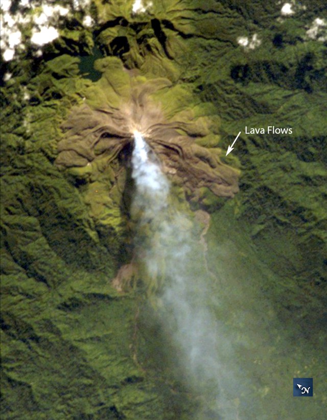
Activity continued to increase during the first week of February. Material from Main Crater traveled as far as 800 m down the Batuawang (S) and Batang (W) drainages and as far as 1 km W down the Beha (W) drainage on 4 February. On 6 February 43 earthquake events were recorded, and on 7 February, 62 events were recorded. White gas-and-steam emissions rose 25-250 m above both summit craters throughout the month. PVMBG reported an eruption began during the evening of 8 February around 1700. Photos showed incandescent material at Main Crater. Incandescent material had also descended the flank in at least two unconfirmed directions as far as 2 km from Main Crater, accompanied by ash plumes (figure 60). As a result, PVMBG increased the Volcano Alert Level (VAL) to 3 (the second highest level on a 1-4 scale).
Occasional nighttime webcam images showed three main incandescent lava flows of differing lengths traveling down the S, SW, and W flanks (figure 61). Incandescent rocks were visible on the upper flanks, possibly from ejected or collapsed material from the crater, and incandescence was the most intense at the summit. Based on analyses of satellite imagery and weather models, the Darwin VAAC reported that daily ash plumes during 16-20 February rose to 2.1-3 km altitude and drifted NNE, E, and SE. BNPB reported on 16 February that as many as 77 people were evacuated and relocated to the East Siau Museum. A webcam image taken at 2156 on 17 February possibly showed incandescent material descending the SE flank. Ash plumes rose to 2.1 km altitude and drifted SE during 22-23 February, according to the Darwin VAAC.
Incandescent avalanches of material and summit incandescence at Main Crater continued during March. White gas-and-steam emissions during March generally rose 25-150 m above the summit crater; on 31 March gas-and-steam emissions rose 200-400 m high. An ash plume rose to 2.4 km altitude and drifted S at 1710 on 9 March and a large thermal anomaly was visible in images taken at 0550 and 0930 on 10 March. Incandescent material was visible at the summit and on the flanks based on webcam images taken at 0007 and 2345 on 16 March, at 1828 on 17 March, at 1940 on 18 March, at 2311 on 19 March, and at 2351 on 20 March. Incandescence was most intense on 18 and 20 March and webcam images showed possible Strombolian explosions (figure 62). An ash plume rose to 2.4 km altitude and drifted SW on 18 March, accompanied by a thermal anomaly.
Summit crater incandescence at Main Crater and on the flanks persisted during April. Incandescent material at the S crater and on the flanks was reported at 0016 on 1 April. The lava flows had stopped by 1 April according to PVMBG, although incandescence was still visible up to 10 m high. Seismic signals indicating effusion decreased and by 6 April they were no longer detected. Incandescence was visible from both summit craters. On 26 April the VAL was lowered to 2 (the second lowest level on a 1-4 scale). White gas-and-steam emissions rose 25-200 m above the summit crater.
During May white gas-and-steam emissions generally rose 50-250 m above the summit, though it was often cloudy, which prevented clear views; on 21 May gas-and-steam emissions rose 50-400 m high. Nighttime N summit crater incandescence rose 10-25 m above the lava dome, and less intense incandescence was noted above Main Crater, which reached about 10 m above the dome. Sounds of falling rocks at Main Crater were heard on 15 May and the seismic network recorded 32 rockfall events in the crater on 17 May. Avalanches traveled as far as 1.5 km down the SW and S flanks, accompanied by rumbling sounds on 18 May. Incandescent material descending the flanks was captured in a webcam image at 2025 on 19 May (figure 63) and on 29 May; summit crater incandescence was observed in webcam images at 2332 on 26 May and at 2304 on 29 May. On 19 May the VAL was again raised to 3.
Occasional Main Crater incandescence was reported during June, as well as incandescent material on the flanks. White gas-and-steam emissions rose 10-200 m above the summit crater. Ash plumes rose to 2.1 km altitude and drifted SE and E during 2-4 June, according to the Darwin VAAC. Material on the flanks of Main Crater were observed at 2225 on 7 June, at 2051 on 9 June, at 0007 on 17 June, and at 0440 on 18 June. Webcam images taken on 21, 25, and 27 June showed incandescence at Main Crater and from material on the flanks.
MIROVA (Middle InfraRed Observation of Volcanic Activity) analysis of MODIS satellite data showed strong thermal activity during mid-February through March and mid-May through June, which represented incandescent avalanches and lava flows (figure 64). During April through mid-May the power of the anomalies decreased but frequent anomalies were still detected. Brief gaps in activity occurred during late March through early April and during mid-June. Infrared satellite images showed strong lava flows mainly affecting the SW and S flanks, accompanied by gas-and-steam emissions (figure 65). According to data recorded by the MODVOLC thermal algorithm, there were a total of 79 thermal hotspots detected: 28 during February, 24 during March, one during April, five during May, and 21 during June.
Geologic Background. Karangetang (Api Siau) volcano lies at the northern end of the island of Siau, about 125 km NNE of the NE-most point of Sulawesi. The stratovolcano contains five summit craters along a N-S line. It is one of Indonesia's most active volcanoes, with more than 40 eruptions recorded since 1675 and many additional small eruptions that were not documented (Neumann van Padang, 1951). Twentieth-century eruptions have included frequent explosive activity sometimes accompanied by pyroclastic flows and lahars. Lava dome growth has occurred in the summit craters; collapse of lava flow fronts have produced pyroclastic flows.
Information Contacts: Pusat Vulkanologi dan Mitigasi Bencana Geologi (PVMBG, also known as Indonesian Center for Volcanology and Geological Hazard Mitigation, CVGHM), Jalan Diponegoro 57, Bandung 40122, Indonesia (URL: http://www.vsi.esdm.go.id/); MAGMA Indonesia, Kementerian Energi dan Sumber Daya Mineral (URL: https://magma.esdm.go.id/v1); Badan Nasional Penanggulangan Bencana (BNPB), National Disaster Management Agency, Graha BNPB - Jl. Scout Kav.38, East Jakarta 13120, Indonesia (URL: http://www.bnpb.go.id/); Darwin Volcanic Ash Advisory Centre (VAAC), Bureau of Meteorology, Northern Territory Regional Office, PO Box 40050, Casuarina, NT 0811, Australia (URL: http://www.bom.gov.au/info/vaac/); MIROVA (Middle InfraRed Observation of Volcanic Activity), a collaborative project between the Universities of Turin and Florence (Italy) supported by the Centre for Volcanic Risk of the Italian Civil Protection Department (URL: http://www.mirovaweb.it/); Hawai'i Institute of Geophysics and Planetology (HIGP) - MODVOLC Thermal Alerts System, School of Ocean and Earth Science and Technology (SOEST), Univ. of Hawai'i, 2525 Correa Road, Honolulu, HI 96822, USA (URL: http://modis.higp.hawaii.edu/); Copernicus Browser, Copernicus Data Space Ecosystem, European Space Agency (URL: https://dataspace.copernicus.eu/browser/); IDN Times, Jl. Jend. Gatot Subroto Kav. 27 3rd Floor Kuningan, Jakarta, Indonesia 12950, Status of Karangetang Volcano in Sitaro Islands Increases (URL: https://sulsel.idntimes.com/news/indonesia/savi/status-gunung-api-karangetang-di-kepulauan-sitaro-meningkat?page=all).
Ahyi (United States) — July 2023 Cite this Report
Ahyi
United States
20.42°N, 145.03°E; summit elev. -75 m
All times are local (unless otherwise noted)
Intermittent hydroacoustic signals and discolored plumes during November 2022-June 2023
Ahyi seamount is a large, conical submarine volcano that rises to within 75 m of the ocean surface about 18 km SE of the island of Farallon de Pajaros in the Northern Marianas. The remote location of the seamount has made eruptions difficult to document, but seismic stations installed in the region confirmed an eruption in the vicinity in 2001. No new activity was detected until April-May 2014 when an eruption was detected by NOAA (National Oceanic and Atmospheric Administration) divers, hydroacoustic sensors, and seismic stations (BGVN 42:04). New activity was first detected on 15 November by hydroacoustic sensors that were consistent with submarine volcanic activity. This report covers activity during November 2022 through June 2023 based on daily and weekly reports from the US Geological Survey.
Starting in mid-October, hydroacoustic sensors at Wake Island (2.2 km E) recorded signals consistent with submarine volcanic activity, according to a report from the USGS issued on 15 November 2022. A combined analysis of the hydroacoustic signals and seismic stations located at Guam and Chichijima Island, Japan, suggested that the source of this activity was at or near the Ahyi seamount. After a re-analysis of a satellite image of the area that was captured on 6 November, USGS confirmed that there was no evidence of discoloration at the ocean surface. Few hydroacoustic and seismic signals continued through November, including on 18 November, which USGS suggested signified a decline or pause in unrest. A VONA (Volcano Observatory Notice for Aviation) reported that a discolored water plume was persistently visible in satellite data starting on 18 November (figure 6). Though clouds often obscured clear views of the volcano, another discolored water plume was captured in a satellite image on 26 November. The Aviation Color Code (ACC) was raised to Yellow (the second lowest level on a four-color scale) and the Volcano Alert Level (VAL) was raised to Advisory (the second lowest level on a four-level scale) on 29 November.
During December, occasional detections were recorded on the Wake Island hydrophone sensors and discolored water over the seamount remained visible. During 2-7, 10-12, and 16-31 December possible explosion signals were detected. A small area of discolored water was observed in high-resolution Sentinel-2 satellite images during 1-6 December (figure 7). High-resolution satellite images recorded discolored water plumes on 13 December that originated from the summit region; no observations indicated that activity breached the ocean surface. A possible underwater plume was visible in satellite images on 18 December, and during 19-20 December a definite but diffuse underwater plume located SSE from the main vent was reported. An underwater plume was visible in a satellite image taken on 26 December (figure 7).
Hydrophone sensors continued to detect signals consistent with possible explosions during 1-8 January 2023. USGS reported that the number of detections decreased during 4-5 January. The hydrophone sensors experienced a data outage that started at 0118 on 8 January and continued through 10 January, though according to USGS, possible explosions were recorded prior to the data outage and likely continued during the outage. A discolored water plume originating from the summit region was detected in a partly cloudy satellite image on 8 January. On 11-12 and 15-17 January possible explosion signals were recorded again. One small signal was detected during 22-23 January and several signals were recorded on 25 and 31 January. During 27-31 January a plume of discolored water was observed above the seamount in satellite imagery (figure 8).
Low levels of activity continued during February and March, based on data from pressure sensors on Wake Island. During 1 and 4-6 February activity was reported, and a submarine plume was observed on 4 February (figure 8). Possible explosion signals were detected during 7-8, 10, 13-14, and 24 February. During 1-2 and 3-5 March a plume of discolored water was observed in satellite imagery (figure 8). Almost continuous hydroacoustic signals were detected in remote pressure sensor data on Wake Island 2,270 km E from the volcano during 7-13 March. During 12-13 March water discoloration around the seamount was observed in satellite imagery, despite cloudy weather. By 14 March discolored water extended about 35 km, but no direction was noted. USGS reported that the continuous hydroacoustic signals detected during 13-14 March stopped abruptly on 14 March and no new detections were observed. Three 30 second hydroacoustic detections were reported during 17-19 March, but no activity was visible due to cloudy weather. A data outage was reported during 21-22 March, making pressure sensor data unavailable; a discolored water plume was, however, visible in satellite data. A possible underwater explosion signal was detected by pressure sensors at Wake Island on 26, 29, and 31 March, though the cause and origin of these events were unclear.
Similar low activity continued during April, May, and June. Several signals were detected during 1-3 April in pressure sensors at Wake Island. USGS suggested that these may be related to underwater explosions or earthquakes at the volcano, but no underwater plumes were visible in clear satellite images. The pressure sensors had data outages during 12-13 April and no data were recorded; no underwater plumes were visible in satellite images, although cloudy weather obscured most clear views. Eruptive activity was reported starting at 2210 on 21 May. On 22 May a discolored water plume that extended 4 km was visible in satellite images, though no direction was recorded. During 23-24 May some signals were detected by the underwater pressure sensors. Possible hydroacoustic signals were detected during 2-3 and 6-8 June. Multiple hydroacoustic signals were detected during 9-11 and 16-17 June, although no activity was visible in satellite images. One hydroacoustic signal was detected during 23-24 June, but there was some uncertainty about its association with volcanic activity. A single possible hydroacoustic signal was detected during 30 June to 1 July.
Geologic Background. Ahyi seamount is a large conical submarine volcano that rises to within 75 m of the ocean surface ~18 km SE of the island of Farallon de Pajaros in the northern Marianas. Water discoloration has been observed there, and in 1979 the crew of a fishing boat felt shocks over the summit area, followed by upwelling of sulfur-bearing water. On 24-25 April 2001 an explosive eruption was detected seismically by a station on Rangiroa Atoll, Tuamotu Archipelago. The event was well constrained (+/- 15 km) at a location near the southern base of Ahyi. An eruption in April-May 2014 was detected by NOAA divers, hydroacoustic sensors, and seismic stations.
Information Contacts: US Geological Survey, Volcano Hazards Program (USGS-VHP), 12201 Sunrise Valley Drive, Reston, VA, USA, https://volcanoes.usgs.gov/index.html; Copernicus Browser, Copernicus Data Space Ecosystem, European Space Agency (URL: https://dataspace.copernicus.eu/browser/).
Kadovar (Papua New Guinea) — June 2023 Cite this Report
Kadovar
Papua New Guinea
3.608°S, 144.588°E; summit elev. 365 m
All times are local (unless otherwise noted)
An ash plume and weak thermal anomaly during May 2023
Kadovar is a 2-km-wide island that is the emergent summit of a Bismarck Sea stratovolcano. It lies off the coast of New Guinea, about 25 km N of the mouth of the Sepik River. Prior to an eruption that began in 2018, a lava dome formed the high point of the volcano, filling an arcuate landslide scarp open to the S. Submarine debris-avalanche deposits occur to the S of the island. The current eruption began in January 2018 and has comprised lava effusion from vents at the summit and at the E coast; more recent activity has consisted of ash plumes, weak thermal activity, and gas-and-steam plumes (BGVN 48:02). This report covers activity during February through May 2023 using information from the Darwin Volcanic Ash Advisory Center (VAAC) and satellite data.
Activity during the reporting period was relatively low and mainly consisted of white gas-and-steam plumes that were visible in natural color satellite images on clear weather days (figure 67). According to a Darwin VAAC report, at 2040 on 6 May an ash plume rose to 4.6 km altitude and drifted W; by 2300 the plume had dissipated. MODIS satellite instruments using the MODVOLC thermal algorithm detected a single thermal hotspot on the SE side of the island on 7 May. Weak thermal activity was also detected in a satellite image on the E side of the island on 14 May, accompanied by a white gas-and-steam plume that drifted SE (figure 68).
Geologic Background. The 2-km-wide island of Kadovar is the emergent summit of a Bismarck Sea stratovolcano of Holocene age. It is part of the Schouten Islands, and lies off the coast of New Guinea, about 25 km N of the mouth of the Sepik River. Prior to an eruption that began in 2018, a lava dome formed the high point of the andesitic volcano, filling an arcuate landslide scarp open to the south; submarine debris-avalanche deposits occur in that direction. Thick lava flows with columnar jointing forms low cliffs along the coast. The youthful island lacks fringing or offshore reefs. A period of heightened thermal phenomena took place in 1976. An eruption began in January 2018 that included lava effusion from vents at the summit and at the E coast.
Information Contacts: Darwin Volcanic Ash Advisory Centre (VAAC), Bureau of Meteorology, Northern Territory Regional Office, PO Box 40050, Casuarina, NT 0811, Australia (URL: http://www.bom.gov.au/info/vaac/); Hawai'i Institute of Geophysics and Planetology (HIGP) - MODVOLC Thermal Alerts System, School of Ocean and Earth Science and Technology (SOEST), Univ. of Hawai'i, 2525 Correa Road, Honolulu, HI 96822, USA (URL: http://modis.higp.hawaii.edu/); Copernicus Browser, Copernicus Data Space Ecosystem, European Space Agency (URL: https://dataspace.copernicus.eu/browser/).
San Miguel (El Salvador) — June 2023 Cite this Report
San Miguel
El Salvador
13.434°N, 88.269°W; summit elev. 2130 m
All times are local (unless otherwise noted)
Small gas-and-ash explosions during March and May 2023
San Miguel in El Salvador is a broad, deep crater complex that has been frequently modified by eruptions recorded since the early 16th century and consists of the summit known locally as Chaparrastique. Flank eruptions have produced lava flows that extended to the N, NE, and SE during the 17-19th centuries. The most recent activity has consisted of minor ash eruptions from the summit crater. The current eruption period began in November 2022 and has been characterized by frequent phreatic explosions, gas-and-ash emissions, and sulfur dioxide plumes (BGVN 47:12). This report describes small gas-and-ash explosions during December 2022 through May 2023 based on special reports from the Ministero de Medio Ambiente y Recursos Naturales (MARN).
Activity has been relatively low since the last recorded explosions on 29 November 2022. Seismicity recorded by the San Miguel Volcano Station (VSM) located on the N flank at 1.7 km elevation had decreased by 7 December. Sulfur dioxide gas measurements taken with DOAS (Differential Optical Absorption Spectroscopy) mobile equipment were below typical previously recorded values: 300 tons per day (t/d). During December, small explosions were recorded by the seismic network and manifested as gas-and-steam emissions.
Gas-and-ash explosions in the crater occurred during January 2023, which were recorded by the seismic network. Sulfur dioxide values remained low, between 300-400 t/d through 10 March. At 0817 on 14 January a gas-and-ash emission was visible in webcam images, rising just above the crater rim. Some mornings during February, small gas-and-steam plumes were visible in the crater. On 7 March at 2252 MARN noted an increase in degassing from the central crater; gas emissions were constantly observed through the early morning hours on 8 March. During the early morning of 8 March through the afternoon on 9 March, 12 emissions were registered, some accompanied by ash. The last gas-and-ash emission was recorded at 1210 on 9 March; very fine ashfall was reported in El Tránsito (10 km S), La Morita (6 km W), and La Piedrita (3 km W). The smell of sulfur was reported in Piedra Azul (5 km SW). On 16 March MARN reported that gas-and-steam emissions decreased.
Low degassing and very low seismicity were reported during April; no explosions have been detected between 9 March and 27 May. The sulfur dioxide emissions remained between 350-400 t/d; during 13-20 April sulfur dioxide values fluctuated between 30-300 t/d. Activity remained low through most of May; on 23 May seismicity increased. An explosion was detected at 1647 on 27 May generated a gas-and-ash plume that rose 700 m high (figure 32); a decrease in seismicity and gas emissions followed. The DOAS station installed on the W flank recorded sulfur dioxide values that reached 400 t/d on 27 May; subsequent measurements showed a decrease to 268 t/d on 28 May and 100 t/d on 29 May.
Geologic Background. The symmetrical cone of San Miguel, one of the most active volcanoes in El Salvador, rises from near sea level to form one of the country's most prominent landmarks. A broad, deep, crater complex that has been frequently modified by eruptions recorded since the early 16th century caps the truncated unvegetated summit, also known locally as Chaparrastique. Flanks eruptions of the basaltic-andesitic volcano have produced many lava flows, including several during the 17th-19th centuries that extended to the N, NE, and SE. The SE-flank flows are the largest and form broad, sparsely vegetated lava fields crossed by highways and a railroad skirting the base of the volcano. Flank vent locations have migrated higher on the edifice during historical time, and the most recent activity has consisted of minor ash eruptions from the summit crater.
Information Contacts: Ministero de Medio Ambiente y Recursos Naturales (MARN), Km. 5½ Carretera a Nueva San Salvador, Avenida las Mercedes, San Salvador, El Salvador (URL: http://www.snet.gob.sv/ver/vulcanologia).
Semisopochnoi (United States) — June 2023 Cite this Report
Semisopochnoi
United States
51.93°N, 179.58°E; summit elev. 1221 m
All times are local (unless otherwise noted)
Occasional explosions, ash deposits, and gas-and-steam plumes during December 2022-May 2023
Semisopochnoi is located in the western Aleutians, is 20-km-wide at sea level, and contains an 8-km-wide caldera. The three-peaked Mount Young (formerly Cerberus) was constructed within the caldera during the Holocene. Each of these peaks contains a summit crater; the lava flows on the N flank appear younger than those on the S side. The current eruption period began in early February 2021 and has more recently consisted of intermittent explosions and ash emissions (BGVN 47:12). This report updates activity during December 2022 through May 2023 using daily, weekly, and special reports from the Alaska Volcano Observatory (AVO). AVO monitors the volcano using local seismic and infrasound sensors, satellite data, web cameras, and remote infrasound and lightning networks.
Activity during most of December 2022 was relatively quiet; according to AVO no eruptive or explosive activity was observed since 7 November 2022. Intermittent tremor and occasional small earthquakes were observed in geophysical data. Continuous gas-and-steam emissions were observed from the N crater of Mount Young in webcam images on clear weather days (figure 25). On 24 December, there was a slight increase in earthquake activity and several small possible explosion signals were detected in infrasound data. Eruptive activity resumed on 27 December at the N crater of Mount Young; AVO issued a Volcano Activity Notice (VAN) that reported minor ash deposits on the flanks of Mount Young that extended as far as 1 km from the vent, according to webcam images taken during 27-28 December (figure 26). No ash plumes were observed in webcam or satellite imagery, but a persistent gas-and-steam plume that might have contained some ash rose to 1.5 km altitude. As a result, AVO raised the Aviation Color Code (ACC) to Orange (the second highest level on a four-color scale) and the Volcano Alert Level (VAL) to Watch (the second highest level on a four-level scale). Possible explosions were detected during 21 December 2022 through 1 January 2023 and seismic tremor was recorded during 30-31 December.
During January 2023 eruptive activity continued at the active N crater of Mount Young. Minor ash deposits were observed on the flanks, extending about 2 km SSW, based on webcam images from 1 and 3 January. A possible explosion occurred during 1-2 January based on elevated seismicity recorded on local seismometers and an infrasound signal recorded minutes later by an array at Adak. Though no ash plumes were observed in webcam or satellite imagery, a persistent gas-and-steam plume rose to 1.5 km altitude that might have carried minor traces of ash. Ash deposits were accompanied by periods of elevated seismicity and infrasound signals from the local geophysical network, which AVO reported were likely due to weak explosive activity. Low-level explosive activity was also detected during 2-3 January, with minor gas-and-steam emissions and a new ash deposit that was visible in webcam images. Low-level explosive activity was detected in geophysical data during 4-5 January, with elevated seismicity and infrasound signals observed on local stations. Volcanic tremor was detected during 7-9 January and very weak explosive activity was detected in seismic and infrasound data on 9 January. Weak seismic and infrasound signals were recorded on 17 January, which indicated minor explosive activity, but no ash emissions were observed in clear webcam images; a gas-and-steam plume continued to rise to 1.5 km altitude. During 29-30 January, ash deposits near the summit were observed on fresh snow, according to webcam images.
The active N cone at Mount Young continued to produce a gas-and-steam plume during February, but no ash emissions or explosive events were detected. Seismicity remained elevated with faint tremor during early February. Gas-and-steam emissions from the N crater were observed in clear webcam images on 11-13 and 16 February; no explosive activity was detected in seismic, infrasound, or satellite data. Seismicity has also decreased, with no significant seismic tremor observed since 25 January. Therefore, the ACC was lowered to Yellow (the second lowest level on a four-color scale) and the VAL was lowered to Advisory (the second lowest level on a four-color scale) on 22 February.
Gas-and-steam emissions persisted during March from the N cone of Mount Young, based on clear webcam images. A few brief episodes of weak tremor were detected in seismic data, although seismicity decreased over the month. A gas-and-steam plume detected in satellite data extended 150 km on 18 March. Low-level ash emissions from the N cone at Mount Young were observed in several webcam images during 18-19 March, in addition to small explosions and volcanic tremor. The ACC was raised to Orange and the VAL increased to Watch on 19 March. A small explosion was detected in seismic and infrasound data on 21 March.
Low-level unrest continued during April, although cloudy weather often obscured views of the summit; periods of seismic tremor and local earthquakes were recorded. During 3-4 April a gas-and-steam plume was visible traveling more than 200 km overnight; no ash was evident in the plume, according to AVO. A gas-and-steam plume was observed during 4-6 April that extended 400 km but did not seem to contain ash. Small explosions were detected in seismic and infrasound data on 5 April. Occasional clear webcam images showed continuing gas-and-steam emissions rose from Mount Young, but no ash deposits were observed on the snow. On 19 April small explosions and tremor were detected in seismic and infrasound data. A period of seismic tremor was detected during 22-25 April, with possible weak explosions on 25 April. Ash deposits were visible near the crater rim, but it was unclear if these deposits were recent or due to older deposits.
Occasional small earthquakes were recorded during May, but there were no signs of explosive activity seen in geophysical data. Gas-and-steam emissions continued from the N crater of Mount Young, based on webcam images, and seismicity remained slightly elevated. A new, light ash deposit was visible during the morning of 5 May on fresh snow on the NW flank of Mount Young. During 10 May periods of volcanic tremor were observed. The ACC was lowered to Yellow and the VAL to Advisory on 17 May due to no additional evidence of activity.
Geologic Background. Semisopochnoi, the largest subaerial volcano of the western Aleutians, is 20 km wide at sea level and contains an 8-km-wide caldera. It formed as a result of collapse of a low-angle, dominantly basaltic volcano following the eruption of a large volume of dacitic pumice. The high point of the island is Anvil Peak, a double-peaked late-Pleistocene cone that forms much of the island's northern part. The three-peaked Mount Cerberus (renamed Mount Young in 2023) was constructed within the caldera during the Holocene. Each of the peaks contains a summit crater; lava flows on the N flank appear younger than those on the south side. Other post-caldera volcanoes include the symmetrical Sugarloaf Peak SSE of the caldera and Lakeshore Cone, a small cinder cone at the edge of Fenner Lake in the NE part of the caldera. Most documented eruptions have originated from Young, although Coats (1950) considered that both Sugarloaf and Lakeshore Cone could have been recently active.
Information Contacts: Alaska Volcano Observatory (AVO), a cooperative program of a) U.S. Geological Survey, 4200 University Drive, Anchorage, AK 99508-4667 USA (URL: https://avo.alaska.edu/), b) Geophysical Institute, University of Alaska, PO Box 757320, Fairbanks, AK 99775-7320, USA, and c) Alaska Division of Geological & Geophysical Surveys, 794 University Ave., Suite 200, Fairbanks, AK 99709, USA (URL: http://dggs.alaska.gov/).
Ebeko
Russia
50.686°N, 156.014°E; summit elev. 1103 m
All times are local (unless otherwise noted)
Continued explosions, ash plumes, and ashfall during October 2022-May 2023
Ebeko, located on the N end of Paramushir Island in the Kuril Islands, consists of three summit craters along a SSW-NNE line at the northern end of a complex of five volcanic cones. Eruptions date back to the late 18th century and have been characterized as small-to-moderate explosions from the summit crater, accompanied by intense fumarolic activity. The current eruption period began in June 2022 and has recently consisted of frequent explosions, ash plumes, and thermal activity (BGVN 47:10). This report covers similar activity during October 2022 through May 2023, based on information from the Kamchatka Volcanic Eruptions Response Team (KVERT) and satellite data.
Activity during October consisted of explosive activity, ash plumes, and occasional thermal anomalies. Visual data by volcanologists from Severo-Kurilsk showed explosions producing ash clouds up to 2.1-3 km altitude which drifted E, N, NE, and SE during 1-8, 10, 16, and 18 October. KVERT issued several Volcano Observatory Notices for Aviation (VONA) on 7, 13-15, and 27 October 2022, stating that explosions generated ash plumes that rose to 2.3-4 km altitude and drifted 5 km E, NE, and SE. Ashfall was reported in Severo-Kurilsk (Paramushir Island, about 7 km E) on 7 and 13 October. Satellite data showed a thermal anomaly over the volcano on 15-16 October. Visual data showed ash plumes rising to 2.5-3.6 km altitude on 22, 25-29, and 31 October and moving NE due to constant explosions.
Similar activity continued during November, with explosions, ash plumes, and ashfall occurring. KVERT issued VONAs on 1-2, 4, 6-7, 9, 13, and 16 November that reported explosions and resulting ash plumes that rose to 1.7-3.6 km altitude and drifted 3-5 km SE, ESE, E, and NE. On 1 November ash plumes extended as far as 110 km SE. On 5, 8, 12, and 24-25 November explosions and ash plumes rose to 2-3.1 km altitude and drifted N and E. Ashfall was observed in Severo-Kurilsk on 7 and 16 November. A thermal anomaly was visible during 1-4, 16, and 20 November. Explosions during 26 November rose as high as 2.7 km altitude and drifted NE (figure 45).
Explosions and ash plumes continued to occur in December. During 1-2 and 4 December volcanologists from Severo-Kurilsk observed explosions that sent ash to 1.9-2.5 km altitude and drifted NE and SE (figure 46). VONAs were issued on 5, 9, and 16 December reporting that explosions generated ash plumes rising to 1.9 km, 2.6 km, and 2.4 km altitude and drifted 5 km SE, E, and NE, respectively. A thermal anomaly was visible in satellite imagery on 16 December. On 18 and 27-28 December explosions produced ash plumes that rose to 2.5 km altitude and drifted NE and SE. On 31 December an ash plume rose to 2 km altitude and drifted NE.
Explosions continued during January 2023, based on visual observations by volcanologists from Severo-Kurilsk. During 1-7 January explosions generated ash plumes that rose to 4 km altitude and drifted NE, E, W, and SE. According to VONAs issued by KVERT on 2, 4, 10, and 23 January, explosions produced ash plumes that rose to 2-4 km altitude and drifted 5 km N, NE, E, and ENE; the ash plume that rose to 4 km altitude occurred on 10 January (figure 47). Satellite data showed a thermal anomaly during 3-4, 10, 13, 16, 21, 22, and 31 January. KVERT reported that an ash cloud on 4 January moved 12 km NE. On 6 and 9-11 January explosions sent ash plumes to 4.5 km altitude and drifted W and ESE. On 13 January an ash plume rose to 3 km altitude and drifted SE. During 20-24 January ash plumes from explosions rose to 3.7 km altitude and drifted SE, N, and NE. On 21 January the ash plume drifted as far as 40 km NE. During 28-29 and 31 January and 1 February ash plumes rose to 4 km altitude and drifted NE.
During February, explosions, ash plumes, and ashfall were reported. During 1, 4-5 and 7-8 February explosions generated ash plumes that rose to 4.5 km altitude and drifted E and NE; ashfall was observed on 5 and 8 February. On 6 February an explosion produced an ash plume that rose to 3 km altitude and drifted 7 km E, causing ashfall in Severo-Kurilsk. A thermal anomaly was visible in satellite data on 8, 9, 13, and 21 February. Explosions on 9 and 12-13 February produced ash plumes that rose to 4 km altitude and drifted E and NE; the ash cloud on 12 February extended as far as 45 km E. On 22 February explosions sent ash to 3 km altitude that drifted E. During 24 and 26-27 February ash plumes rose to 4 km altitude and drifted E. On 28 February an explosion sent ash to 2.5-3 km altitude and drifted 5 km E; ashfall was observed in Severo-Kurilsk.
Activity continued during March; visual observations showed that explosions generated ash plumes that rose to 3.6 km altitude on 3, 5-7, and 9-12 March and drifted E, NE, and NW. Thermal anomalies were visible on 10, 13, and 29-30 March in satellite imagery. On 18, 21-23, 26, and 29-30 March explosions produced ash plumes that rose to 2.8 km altitude and drifted NE and E; the ash plumes during 22-23 March extended up to 76 km E. A VONA issued on 21 March reported an explosion that produced an ash plume that rose to 2.8 km altitude and drifted 5 km E. Another VONA issued on 23 March reported that satellite data showed an ash plume rising to 3 km altitude and drifted 14 km E.
Explosions during April continued to generate ash plumes. On 1 and 4 April an ash plume rose to 2.8-3.5 km altitude and drifted SE and NE. A thermal anomaly was visible in satellite imagery during 1-6 April. Satellite data showed ash plumes and clouds rising to 2-3 km altitude and drifting up to 12 km SW and E on 3 and 6 April (figure 48). KVERT issued VONAs on 3, 5, 14, 16 April describing explosions that produced ash plumes rising to 3 km, 3.5 km, 3.5 km, and 3 km altitude and drifting 5 km S, 5 km NE and SE, 72 km NNE, and 5 km NE, respectively. According to satellite data, the resulting ash cloud from the explosion on 14 April was 25 x 7 km in size and drifted 72-104 km NNE during 14-15 April. According to visual data by volcanologists from Severo-Kurilsk explosions sent ash up to 3.5 km altitude that drifted NE and E during 15-16, 22, 25-26, and 29 April.
The explosive eruption continued during May. Explosions during 3-4, 6-7, and 9-10 May generated ash plumes that rose to 4 km altitude and drifted SW and E. Satellite data showed a thermal anomaly on 3, 9, 13-14, and 24 May. During 12-16, 23-25, and 27-28 May ash plumes rose to 3.5 km altitude and drifted in different directions due to explosions. Two VONA notices were issued on 16 and 25 May, describing explosions that generated ash plumes rising to 3 km and 3.5 km altitude, respectively and extending 5 km E. The ash cloud on 25 May drifted 75 km SE.
Thermal activity in the summit crater, occasionally accompanied by ash plumes and ash deposits on the SE and E flanks due to frequent explosions, were visible in infrared and true color satellite images (figure 49).
Geologic Background. The flat-topped summit of the central cone of Ebeko volcano, one of the most active in the Kuril Islands, occupies the northern end of Paramushir Island. Three summit craters located along a SSW-NNE line form Ebeko volcano proper, at the northern end of a complex of five volcanic cones. Blocky lava flows extend west from Ebeko and SE from the neighboring Nezametnyi cone. The eastern part of the southern crater contains strong solfataras and a large boiling spring. The central crater is filled by a lake about 20 m deep whose shores are lined with steaming solfataras; the northern crater lies across a narrow, low barrier from the central crater and contains a small, cold crescentic lake. Historical activity, recorded since the late-18th century, has been restricted to small-to-moderate explosive eruptions from the summit craters. Intense fumarolic activity occurs in the summit craters, on the outer flanks of the cone, and in lateral explosion craters.
Information Contacts: Kamchatka Volcanic Eruptions Response Team (KVERT), Far Eastern Branch, Russian Academy of Sciences, 9 Piip Blvd., Petropavlovsk-Kamchatsky, 683006, Russia (URL: http://www.kscnet.ru/ivs/kvert/); MIROVA (Middle InfraRed Observation of Volcanic Activity), a collaborative project between the Universities of Turin and Florence (Italy) supported by the Centre for Volcanic Risk of the Italian Civil Protection Department (URL: http://www.mirovaweb.it/); Copernicus Browser, Copernicus Data Space Ecosystem, European Space Agency (URL: https://dataspace.copernicus.eu/browser/).
Home Reef
Tonga
18.992°S, 174.775°W; summit elev. -10 m
All times are local (unless otherwise noted)
Discolored plumes continued during November 2022-April 2023
Home Reef is a submarine volcano located in the central Tonga islands between Lateiki (Metis Shoal) and Late Island. The first recorded eruption occurred in the mid-19th century, when an ephemeral island formed. An eruption in 1984 produced a 12-km-high eruption plume, a large volume of floating pumice, and an ephemeral island 500 x 1,500 m wide, with cliffs 30-50 m high that enclosed a water-filled crater. Another island-forming eruption in 2006 produced widespread pumice rafts that drifted as far as Australia; by 2008 the island had eroded below sea level. The previous eruption occurred during October 2022 and was characterized by a new island-forming eruption, lava effusion, ash plumes, discolored water, and gas-and-steam plumes (BGVN 47:11). This report covers discolored water plumes during November 2022 through April 2023 using satellite data.
Discolored plumes continued during the reporting period and were observed in true color satellite images on clear weather days. Satellite images show light green-yellow discolored water extending W on 8 and 28 November 2022 (figure 31), and SW on 18 November. Light green-yellow plumes extended W on 3 December, S on 13 December, SW on 18 December, and W and S on 23 December (figure 31). On 12 January 2023 discolored green-yellow plumes extended to the NE, E, SE, and N. The plume moved SE on 17 January and NW on 22 January. Faint discolored water in February was visible moving NE on 1 February. A discolored plume extended NW on 8 and 28 March and NW on 13 March (figure 31). During April, clear weather showed green-blue discolored plumes moving S on 2 April, W on 7 April, and NE and S on 12 April. A strong green-yellow discolored plume extended E and NE on 22 April for several kilometers (figure 31).
Geologic Background. Home Reef, a submarine volcano midway between Metis Shoal and Late Island in the central Tonga islands, was first reported active in the mid-19th century, when an ephemeral island formed. An eruption in 1984 produced a 12-km-high eruption plume, large amounts of floating pumice, and an ephemeral 500 x 1,500 m island, with cliffs 30-50 m high that enclosed a water-filled crater. In 2006 an island-forming eruption produced widespread dacitic pumice rafts that drifted as far as Australia. Another island was built during a September-October 2022 eruption.
Information Contacts: Copernicus Browser, Copernicus Data Space Ecosystem, European Space Agency (URL: https://dataspace.copernicus.eu/browser/).
Ambae
Vanuatu
15.389°S, 167.835°E; summit elev. 1496 m
All times are local (unless otherwise noted)
New lava flow, ash plumes, and sulfur dioxide plumes during February-May 2023
Ambae, also known as Aoba, is a large basaltic shield volcano in Vanuatu. A broad pyroclastic cone containing three crater lakes (Manaro Ngoru, Voui, and Manaro Lakua) is located at the summit within the youngest of at least two nested calderas. Periodic phreatic and pyroclastic explosions have been reported since the 16th century. A large eruption more than 400 years ago resulted in a volcanic cone within the summit crater that is now filled by Lake Voui; the similarly sized Lake Manaro fills the western third of the caldera. The previous eruption ended in August 2022 that was characterized by gas-and-steam and ash emissions and explosions of wet tephra (BGVN 47:10). This report covers a new eruption during February through May 2023 that consisted of a new lava flow, ash plumes, and sulfur dioxide emissions, using information from the Vanuatu Meteorology and Geo-Hazards Department (VMGD) and satellite data.
During the reporting period, the Alert Level remained at a 2 (on a scale of 0-5), which has been in place since December 2021. Activity during October 2022 through March 2023 remained relatively low and mostly consisted of gas-and-steam emissions in Lake Voui. VMGD reported that at 1300 on 15 November a satellite image captured a strong amount of sulfur dioxide rising above the volcano (figure 99), and that seismicity slightly increased. The southern and northern part of the island reported a strong sulfur dioxide smell and heard explosions. On 20 February 2023 a gas-and-ash plume rose 1.3 km above the summit and drifted SSW, according to a webcam image (figure 100). Gas-and-steam and possibly ash emissions continued on 23 February and volcanic earthquakes were recorded by the seismic network.
During April, volcanic earthquakes and gas-and-steam and ash emissions were reported from the cone in Lake Voui. VMGD reported that activity increased during 5-7 April; high gas-and-steam and ash plumes were visible, accompanied by nighttime incandescence. According to a Wellington VAAC report, a low-level ash plume rose as high as 2.5 km above the summit and drifted W and SW on 5 April, based on satellite imagery. Reports in Saratamata stated that a dark ash plume drifted to the WSW, but no loud explosion was heard. Webcam images from 2100 showed incandescence above the crater and reflected in the clouds. According to an aerial survey, field observations, and satellite data, water was no longer present in the lake. A lava flow was reported effusing from the vent and traveling N into the dry Lake Voui, which lasted three days. The next morning at 0745 on 6 April a gas-and-steam and ash plume rose 5.4 km above the summit and drifted ESE, based on information from VMGD (figure 101). The Wellington VAAC also reported that light ashfall was observed on the island. Intermittent gas-and-steam and ash emissions were visible on 7 April, some of which rose to an estimated 3 km above the summit and drifted E. Webcam images during 0107-0730 on 7 April showed continuing ash emissions. A gas-and-steam and ash plume rose 695 m above the summit crater at 0730 on 19 April and drifted ESE, based on a webcam image (figure 102).
According to visual and infrared satellite data, water was visible in Lake Voui as late as 24 March 2023 (figure 103). The vent in the caldera showed a gas-and-steam plume drifted SE. On 3 April thermal activity was first detected, accompanied by a gas-and-ash plume that drifted W (figure 103). The lava flow moved N within the dry lake and was shown cooling by 8 April. By 23 April much of the water in the lake had returned. Occasional sulfur dioxide plumes were detected by the TROPOMI instrument on the Sentinel-5P satellite that exceeded 2 Dobson Units (DU) and drifted in different directions (figure 104).
Geologic Background. The island of Ambae, also known as Aoba, is a massive 2,500 km3 basaltic shield that is the most voluminous volcano of the New Hebrides archipelago. A pronounced NE-SW-trending rift zone with numerous scoria cones gives the 16 x 38 km island an elongated form. A broad pyroclastic cone containing three crater lakes (Manaro Ngoru, Voui, and Manaro Lakua) is located at the summit within the youngest of at least two nested calderas, the largest of which is 6 km in diameter. That large central edifice is also called Manaro Voui or Lombenben volcano. Post-caldera explosive eruptions formed the summit craters about 360 years ago. A tuff cone was constructed within Lake Voui (or Vui) about 60 years later. The latest known flank eruption, about 300 years ago, destroyed the population of the Nduindui area near the western coast.
Information Contacts: Geo-Hazards Division, Vanuatu Meteorology and Geo-Hazards Department (VMGD), Ministry of Climate Change Adaptation, Meteorology, Geo-Hazards, Energy, Environment and Disaster Management, Private Mail Bag 9054, Lini Highway, Port Vila, Vanuatu (URL: http://www.vmgd.gov.vu/, https://www.facebook.com/VanuatuGeohazardsObservatory/); Wellington Volcanic Ash Advisory Centre (VAAC), Meteorological Service of New Zealand Ltd (MetService), PO Box 722, Wellington, New Zealand (URL: http://www.metservice.com/vaac/, http://www.ssd.noaa.gov/VAAC/OTH/NZ/messages.html); MIROVA (Middle InfraRed Observation of Volcanic Activity), a collaborative project between the Universities of Turin and Florence (Italy) supported by the Centre for Volcanic Risk of the Italian Civil Protection Department (URL: http://www.mirovaweb.it/); Global Sulfur Dioxide Monitoring Page, Atmospheric Chemistry and Dynamics Laboratory, NASA Goddard Space Flight Center (NASA/GSFC), 8800 Greenbelt Road, Goddard, Maryland, USA (URL: https://so2.gsfc.nasa.gov/); Copernicus Browser, Copernicus Data Space Ecosystem, European Space Agency (URL: https://dataspace.copernicus.eu/browser/).
Search Bulletin Archive by Publication Date
Select a month and year from the drop-downs and click "Show Issue" to have that issue displayed in this tab.
The default month and year is the latest issue available.
Bulletin of the Global Volcanism Network - Volume 36, Number 01 (February 2011)
Managing Editor: Richard Wunderman
Bagana (Papua New Guinea)
Occasional ash plumes during 11 February-1 October 2010
Karangetang (Indonesia)
Eruption in August 2010 isolated 20,000 residents and caused four deaths
Kizimen (Russia)
Powerful fissure eruption in November 2010 ends ~82-year repose
Manam (Papua New Guinea)
Ashfall, pyroclastic flows, and seismicity in late December 2010
Merapi (Indonesia)
Eruption started 26 October 2010; 386 deaths, more than 300,000 evacuated
Rumble III (New Zealand)
Eruption in 2009 linked to over 100 m of sea floor collapse
Sangay (Ecuador)
Many plumes seen by pilots during past year ending February 2011
Taal (Philippines)
Intermittent non-eruptive unrest during 2008-2010
Bagana (Papua New Guinea) — February 2011 Cite this Report
Bagana
Papua New Guinea
6.137°S, 155.196°E; summit elev. 1855 m
All times are local (unless otherwise noted)
Occasional ash plumes during 11 February-1 October 2010
This report discusses thermal anomalies and occasional ash plumes at Bagana during February into October 2010, with some satellite thermal data (MODVOLC) as late as early 2011. Our previous report (BGVN 35:02) also noted small lava flows, occasional ash plumes, and thermal anomalies from October 2009 through February 2010.
Historical records describe frequent eruptions since 1842. Bagana lacks instrumental monitoring and sits far from population centers. Many recent observations are remote-sensing based, although the Rabaul Volcano Observatory (RVO) produces reports with direct air- and ground-based observations. Bagana's flanks are covered with andesitic lava flows up to 50 m thick (Blake, 1968). The flows typically descend the mid-slope within the confines of tall lava levees, but emerge from the levees on the outer flanks to form sub-circular flow fields. Bagana's thick lava flows are visible [from the International Space Station] (figure 11).
Activity. Between 10 February 2010 and 1 October 2010, the Darwin Volcanic Ash Advisory Center (VAAC) reported one or a few ash plumes per month from Bagana. Many rose to ~3 km and drifted from 20-205 km (table 5). According to RVO, ash plumes were seen on 5 February and night-time incandescence was seen on 2, 12, 13, and 19 February. White vapor was emitted during 1-21 February. Sulfur dioxide plumes drifted ENE during 11-20 February and NNW on 20 and 21 February. Consistent with the thick lava flows, MODVOLC detected well over 100 thermal anomalies at Bagana in the year ending 10 February 2011.
Table 5. Summary of ash plumes from Bagana reported during 1 February-October 2010. Courtesy of the Darwin Volcanic Ash Advisory Centre (VAAC).
| Date |
Altitude (km) |
Drift (distance and direction) |
| 11-15 Feb 2010 |
2.4 |
18-150 km E, NE |
| 19-20, 23, 25 and 27 Apr 2010 |
1.5-3 |
35-85 km S, SW, W, NW |
| 06, 10-12 May 2010 |
2.4-3 |
55-75 km W, SW, WSW |
| 25-28 May 2010 |
3 |
30-185 km NW, W, SW |
| 13-14 Jun 2010 |
3 |
75-205 km SW, W |
| 04 Jul 2010 |
2.4 |
75 km W |
| 10-11 Jul 2010 |
2.4 |
75-150 km SW |
| 13-15 Aug 2010 |
2.4 |
75 km SW, W |
| 01 Oct 2010 |
2.4 |
75 km NW |
Reference. Blake D H, 1968. Post Miocene volcanoes on Bougainville Island, Territory of Papua and New Guinea. Bull Volc, 32: 121-140
Geologic Background. Bagana volcano, in a remote portion of central Bougainville Island, is frequently active. This massive symmetrical cone was largely constructed by an accumulation of viscous andesitic lava flows. The entire edifice could have been constructed in about 300 years at its present rate of lava production. Eruptive activity is characterized by non-explosive effusion of viscous lava that maintains a small lava dome in the summit crater, although occasional explosive activity produces pyroclastic flows. Lava flows with tongue-shaped lobes up to 50 m thick and prominent levees descend the flanks on all sides.
Information Contacts: Darwin Volcanic Ash Advisory Centre (VAAC), Bureau of Meteorology, Northern Territory Regional Office, PO Box 40050, Casuarina, NT 0811, Australia (URL: http://www.bom.gov.au/info/vaac/); Rabaul Volcano Observatory (RVO), PO Box 386, Rabaul, Papua New Guinea; NASA Earth Observatory (URL: http://earthobservatory.nasa.gov/); Hawai'i Institute of Geophysics and Planetology (HIGP) MODVOLC Thermal Alerts System, School of Ocean and Earth Science and Technology (SOEST), Univ. of Hawai'i, 2525 Correa Road, Honolulu, HI 96822, USA (URL: http://modis.higp.hawaii.edu/); Image Science and Analysis Laboratory, NASA-Marshall Space Flight Center (URL: http://eol.jsc.nasa.gov).
Karangetang (Indonesia) — February 2011 Cite this Report
Karangetang
Indonesia
2.781°N, 125.407°E; summit elev. 1797 m
All times are local (unless otherwise noted)
Eruption in August 2010 isolated 20,000 residents and caused four deaths
A sudden eruption at Karangetang on 6 August 2010 occurred without warning and caused considerable damage. This report covers the interval from 6 August 2010 to mid-March 2011. Previously, the Indonesian Center of Volcanology and Geological Hazard Mitigation (CVGHM) had reported that, after explosions and lava flows during May and June 2009 and a pyroclastic flow and lahar in November 2009, seismicity had declined through early February 2010 (BGVN 35:01). On 12 February 2010, CVGHM had lowered the Alert Level to 2 (on a scale of 1-4).
According to news articles, an explosion on 6 August 2010 ejected hot clouds of gas and sent pyroclastic flows down the W flank. At least one house was buried and several other buildings, including a church, were damaged. A damaged bridge isolated about six villages and their ~20,000 residents, and communication links were lost. According to news reports (CNN and Associated Press), four people were confirmed dead and five were injured, and about 65 were evacuated. The Darwin Volcanic Ash Advisory Centre (VAAC) reported that an ash plume rose to an altitude of 9.1 km and drifted W on that same day.
The news reports cited CVGHM official Priyadi Kardono as noting that the volcano erupted just after midnight when water from heavy rains had penetrated the volcano's hot lava dome, causing the explosion. According to these reports, Kardono said volcanologists did not issue a warning about the eruption because there were no indications of increased volcanic activity. Kardono also noted that the explosion was not large, and the flow of volcanic debris had since decreased.
CVGHM reported that during 1-21 September 2010, lava traveled 75-500 m down Karangetang's flanks and avalanches traveled as far as 2 km down multiple drainages, to the S, E, and W. Incandescent material was ejected up to 500 m above the crater. Ashfall was reported in areas to the NW.
On 21 and 22 September incandescent material traveled down multiple drainages. Strombolian activity was observed on 22 September; material ejected 50 m high fell back down around the crater. That same day, the Alert level was raised to 3.
During November and early December 2010, CVGHM noted a drastic decrease in the occurrence of pyroclastic flows on Karangetang's flanks. Seismicity also decreased. The only reports were of white plumes that rose up to 300 m above the craters. The Alert Level was thus lowered to 2 on 13 December 2010.
According to CVGHM, the Alert Level was again raised from 2 to 3 on 11 March 2011 due to increased seismicity. According to news reports, lava flows were visible and blocks originating from the lava dome traveled as far as 2 km down the flanks, along with hot gas clouds. A Reuters News photo published in Okezone News showed a moderate Strombolian eruption venting from the summit on 11 March, with an apron of incandescent spatter dotting the upper slopes, and a swath of red spatter and bombs bouncing down one flank. Darwin VAAC reported that on that same day, an ash plume rose to an altitude of 2.4 km and drifted 55 km SW; on 13 March, another ash plume rose to an altitude of 3.7 km and drifted 37 km.
During 12-16 March, CVGHM stated that bluish gas plumes rose 50-150 m above the main crater. On 17 March lava flows traveled as far as 2 km from the main crater, accompanied by roaring and booming noises.
On 18 and 20 March lava flows traveled 1.5-1.8 km and collapses from the lava flow fronts generated avalanches that moved another 500 m. Avalanches from the crater traveled 3.8 km down the flanks. Multiple pyroclastic flows about 1.5-2.3 km long destroyed a bridge, damaged a house, and trapped 31 people (later rescued) between the flow paths. Later that day, pyroclastic flows traveled 4 km, reaching the shore. The Alert Level was raised to 4. According to news articles, 600-1,200 people were evacuated from villages on the W flank.
During the week after 20 March, seismicity and deformation declined. The number of new lava flows also declined.
MODVOLC Thermal Alerts. Thermal alerts derived from the Hawai'i Institute of Geophysics and Planetology Thermal Alerts System (MODVOLC) were reported through 19 February 2010 in BGVN 35:01. A significant number of alerts were measured on 19 March 2010 (14 pixels at 0215 UCT on Terra) and 23 March (1 pixel on Aqua), followed by ~5 months without measured alerts. Alerts reappeared during 16 August-19 October 2010. Alerts were absent between 20 October 2010 and 10 March 2011, followed by renewed alerts during 11-12 March 2011.
Geologic Background. Karangetang (Api Siau) volcano lies at the northern end of the island of Siau, about 125 km NNE of the NE-most point of Sulawesi. The stratovolcano contains five summit craters along a N-S line. It is one of Indonesia's most active volcanoes, with more than 40 eruptions recorded since 1675 and many additional small eruptions that were not documented (Neumann van Padang, 1951). Twentieth-century eruptions have included frequent explosive activity sometimes accompanied by pyroclastic flows and lahars. Lava dome growth has occurred in the summit craters; collapse of lava flow fronts have produced pyroclastic flows.
Information Contacts: Center of Volcanology and Geological Hazard Mitigation (CVGHM), Jalan Diponegoro 57, Bandung 40122, Indonesia (URL: http://vsi.esdm.go.id/); Darwin Volcanic Ash Advisory Centre (VAAC), Bureau of Meteorology, Northern Territory Regional Office, PO Box 40050, Casuarina, NT 0811, Australia (URL: http://www.bom.gov.au/info/vaac/); Hawai'i Institute of Geophysics and Planetology (HIGP) MODVOLC Thermal Alerts System, School of Ocean and Earth Science and Technology (SOEST), Univ. of Hawai'i, 2525 Correa Road, Honolulu, HI 96822, USA (URL: http://modis.higp.hawaii.edu/); Okezone News (URL: http://news.okezone.com/read/2011/03/12/340/434280/gunung-muntahkan-lava-pijar); Associated Press (URL: http://www.ap.org/); Reuters (URL: http://www.reuters.com/); CNN (URL: http://www.cnn.com/); Straits Times (URL: http://www.straitstimes.com/); Novinite (URL: http://www.novinite.com/).
Kizimen (Russia) — February 2011 Cite this Report
Kizimen
Russia
55.131°N, 160.32°E; summit elev. 2334 m
All times are local (unless otherwise noted)
Powerful fissure eruption in November 2010 ends ~82-year repose
Eruption began here during mid-November 2010, the first since 1927-1928 (Brown and other, 2010). Ash plumes rose to ~10 km and were visible in satellite imagery as they traveled hundreds of kilometers during November 2010 through at least late February 2011. Our previous Bulletin (BGVN 35:02) reported that the number of earthquakes at Kizimen had increased substantially beginning in July 2009 (up to 120 earthquakes per day) through early April 2010 and that fumarolic temperatures increased in August. This report discusses activity since early April 2010.
After early April 2010, seismicity at Kizimen entered a quiescent phase until the Kamchatkan Volcanic Eruption Response Team (KVERT) reported increased seismic activity on 20 August and particularly during early November 2010. Based on information from a tourist center 10 km from Kizimen, KVERT noted that on 11 November 2010, strong gas-and-steam emissions resulted in a plume, possibly containing some ash, that rose to an altitude of 4 km.
According to the Kamchatkan Branch of Geophysical Survey (KG GS RAS), seismicity of the volcano was above background levels all week, and an M 4 earthquake occurred on 16 November 2010. According to information from the Yelizovo Airport (UHPP), the Tokyo VAAC reported that on 17 November an ash plume from Kizimen rose to an altitude of 3 km and drifted NE. KVERT noted the lack of satellite data about ash near Kizimen. The Level of Aviation Color Code remained at Green (on a scale that goes from low to high using these terms: Green, Yellow, Orange, and Red).
Seismic activity was above background levels during 19 November to 24 December 2010. On 20 November, volcanologists flying around Kizimen by helicopter observed several new fumaroles at the summit and SW flank. A small amount of "dust" covered the SW flank, possibly ash from the new fumaroles. Activity at the established old fumarole "Revuschaya" on the volcano's NE flank decreased. No thermal anomaly was noted from satellite images. The Level of Aviation Color Code was raised to Yellow.
On 9 December 2010, seismicity increased significantly and the Aviation Color Code level was raised to Orange. That same day, the Tokyo VAAC reported that, according to KB GS RAS, an explosion produced a plume that rose to an altitude of 2.7 km and drifted N. Ash was not identified in satellite images. A bright thermal anomaly was observed in satellite imagery the next day.
The beginning of the eruption Kizimen was captured in in a photo made by Don Page on 10 December from a commercial flight. The eruption start from long fissure on the SE slope (figure 5).
[On 13 December 2010 (UTC) an explosive eruption generated ash plumes that rose to altitudes of 3-3.5 km and drifted NW. Based on information from KEMSD and analysis of satellite imagery, the Tokyo VAAC reported that an ash plume rose to an altitude of 10 km and drifted N. KVERT noted that lightning in the ash plumes was observed. The Aviation Color Code was raised to Red. Ash deposits in Kozyrevsk and Tigil, 110 and 308 km NW, respectively, were 5 mm thick. Later that day seismic activity decreased; the Aviation Color Code was lowered to Orange.]
Kronotsky National Park staff, residing at Ipuin (~16 km WSW), noted that the water level in Levaya Schapina river rose 60 cm after the explosions and remained elevated for the next two days. The water was also very muddy. During 14-24 December seismicity remained above background and a thermal anomaly over the lava dome was detected in satellite imagery.
KVERT noted that during 17-24 December 2010 the number of shallow seismic earthquakes increased from 110 events on 17 December to 304 events on 22 December. Volcanic tremor was detected on 23 December. During 26-28 December, seismicity also increased and there were possible small ash explosions and hot avalanches. A thermal anomaly over the lava dome was again seen in satellite imagery. On 27 December seismic analysis indicated that ash plumes that day possibly rose to altitudes of 3.5-4.5 km. Satellite imagery showed ash plumes drifting 140 km W at an altitude of 4 km. On 28 December, based on a Yelizovo Airport (UHPP) notice, the Tokyo VAAC reported an ash plume drifting W at an altitude of 3.7 km. The Aviation Color Code was raised to Red.
A thermal anomaly over Kizimen's lava dome was again observed in satellite imagery during 29 December 2010-1 January 2011 and an explosive eruption that began on 13 December continued. On 31 December seismicity increased and volcanic tremor was detected. Explosions occurred sporadically for a period of about 20 minutes. Ash plumes detected in satellite imagery rose to an altitude of 8 km and drifted SW. Ashfall at least 1 mm thick occurred in multiple areas 225-275 km SSW, including Petropavlovsk-Kamchatsky, Yelizovo, Paratunka, and Nalychevo. Ash plumes at an altitude of 4 km drifted 480-500 km SW; ash continued to accumulate in some areas.
Seismic data indicated increased activity on 3 January. Based on analysis of satellite imagery, the Tokyo VAAC reported that possible eruptions during 2-4 January produced plumes that rose to an altitude of 3-4.6 km and drifted S, E, and NE. Subsequent images on those same days showed ash emissions continuing, then dissipating. During 4-7 January seismicity remained high and variable and volcanic tremor continued. A thermal anomaly over the volcano was observed in satellite imagery. Explosions continued through 7 January 2011 producing ash plumes mostly below altitudes of 6-8 km as reported by pilots or observed in satellite imagery. These drifted more than 200 km SE. A large and bright thermal anomaly was observed in satellite imagery.
A pattern of high seismicity and ash emissions was noted during early January 2011. On 5 January ash plumes drifted more than 500 km ENE. Ashfall was reported on the Komandorsky Islands, 350-500 km E (figure 6).
The Tokyo VAAC reported that ash continued to be observed in satellite imagery on 5 January. According to information from KVERT and analyses of satellite imagery, a possible eruption on 6 January produced a plume that rose to an altitude of 3.7 km and drifted E. Subsequent satellite images that same day showed continuing ash emissions. Ash plumes drifted NW on 9 January, and drifted NW again on 11 January 2011, at an altitude of 2.7 km.
KVERT reported that during 7-13 January 2011 they saw both a thermal anomaly over Kizimen in satellite imagery and pyroclastic flow deposits on the E flank. Seismicity recorded during 6-7 and 12 January was high but variable, and many shallow volcanic earthquakes as well as volcanic tremor continued to be detected. Ash plumes that rose to altitudes of 6-8 km during 5-13 January were seen drifting multiple directions, and appeared in satellite imagery to be drifting more than 275 km W and NW. On 12 January ashfall was reported in the villages of Anavgai and Esso, 140 km NW. Seismic data during 14-15 January suggested that ash plumes rose to altitudes of 4-5 km. Satellite images showed a bright thermal anomaly over the volcano and ash plumes drifting more than 180 km W on 15 January 2011. The Aviation Color Code level was lowered to Orange.
From 14 January through 1 February, KVERT reported that seismicity from Kizimen was high but variable, and many shallow volcanic earthquakes as well as volcanic tremor continued to be detected. Seismic data analyses suggested that ash plumes possibly rose to an altitude no higher than 6 km. Satellite images showed a daily bright thermal anomaly over the volcano, and ash plumes that drifted more than 200 km W during 15-16 and 20 January. Based on satellite data, the Tokyo VAAC also reported that during 23-25 January eruptions produced plumes that rose to altitudes of 4.9-10.1 km. Based on analyses of satellite imagery, the Tokyo VAAC reported that a possible eruption on 29 January produced a plume that rose to an altitude of 3.7 km and drifted SW. Photo and satellite images taken during late January through late February showed continuing ash emissions (figures 7 and 8).
Reference: Browne B., Izbekov, P., Eichelberger, J., and Churikova, T., 2010, Pre-eruptive storage conditions of the Holocene dacite erupted from Kizimen Volcano, Kamchatka: International Geology Review, v. 52, Issue 1 January 2010, p. 95-110.
Geologic Background. Kizimen is an isolated, conical stratovolcano that is morphologically similar to St. Helens prior to its 1980 eruption. The summit consists of overlapping lava domes, and blocky lava flows descend the flanks of the volcano, which is the westernmost of a volcanic chain north of Kronotsky volcano. The 2334-m-high edifice was formed during four eruptive cycles beginning about 12,000 years ago and lasting 2000-3500 years. The largest eruptions took place about 10,000 and 8300-8400 years ago, and three periods of long-term lava dome growth have occurred. The latest eruptive cycle began about 3000 years ago with a large explosion and was followed by intermittent lava dome growth lasting about 1000 years. An explosive eruption about 1100 years ago produced a lateral blast and created a 1.0 x 0.7 km wide crater breached to the NE, inside which a small lava dome (the fourth at Kizimen) has grown. Prior to 2010, only a single explosive eruption, during 1927-28, had been recorded in historical time.
Information Contacts: Kamchatka Volcanic Eruptions Response Team (KVERT), Institute of Volcanology and Seismology Russian Academy of Sciences, Far East Division, 9 Piip Blvd., Petropavlovsk-Kamchatsky, 683006, Russia (URL: http://www.kscnet.ru/ivs/); Kamchatka Branch of the Geophysical Service of the Russian Academy of Sciences (KB GS RAS), Piip Ave. 9, Petropavlovsk-Kamchatsky, 683006, Russia (URL: http://www.kscnet.ru/ivs/); Sergey Senukov, Russia (URL: http://www.emsd.ru/) Valery Droznin and Sergey Chirkov, Institute of Volcanology and Seismology Russian Academy of Sciences, Far Eastern Branch, 9 Piip Boulevard, Petropavlovsk-Kamchatsky, 683006, Russia; A. Lobashevsky (URL: http://www.photokamchatka.ru/); I. Shpilenok (URL: http://shpilenok.livejournal.com/44922.html); NASA Earth Observatory (URL: http://earthobservatory.nasa.gov/); Don Nelson Page, Theoretical Physics Institute, 412 Physics Lab., University of Alberta, Edmonton, Alberta T6G 2J1, Canada.
Manam (Papua New Guinea) — February 2011 Cite this Report
Manam
Papua New Guinea
4.08°S, 145.037°E; summit elev. 1807 m
All times are local (unless otherwise noted)
Ashfall, pyroclastic flows, and seismicity in late December 2010
This report discusses Manam behavior during November 2010 to early 2011. As previously reported, during August-October 2010, lava fragments and ash plumes rose from Manam (BGVN 35:09). Similar activity continued through at least 4 January 2011. Over 10,000 former island residents remain in care centers on the mainland (see below).
During the reporting period, the Rabaul Volcano Observatory (RVO) reported that the Main Crater produced mostly white plumes that were occasionally laden with ash. Incandescent material was ejected at times and mainly fell back in and around the crater, but occasionally spilled into the SE and SW valleys.
Based on analysis of satellite imagery, the Darwin Volcanic Ash Advisory Centre (VAAC) reported that ash plumes during 14-16 November 2010 rose to an altitude of 2.7 km and drifted ~95 km NW.
RVO reported that light brown to dark gray ash plumes rose 400-500 m above the South Crater during late November. People living on the island reported occasional roaring and rumbling noises. A new episode of eruptive activity began at South Crater on 25 December and was characterized during 25-29 December by rising ash plumes and ejections of incandescent lava fragments. Electronic tilt measurements showed a strong inflationary trend during 24-26 December but this slowed down on 26 December.
On 30 December 2010, activity from South Crater increased and was reported by observers in Bogia (on the mainland 20 km SSW). A dense ash plume rose 3 km above the summit crater and drifted NW, causing light ashfall in Tabele (4 km SW of Manam). An observer at Tabele confirmed the eruption and also reported that three pyroclastic flows descended the SE valley, stopping within a few to several hundred meters from the coastline. The first and largest pyroclastic flow devastated a broad unpopulated area between Warisi (E of Manam) and Dugulava (S of Manam) villages. RVO increased the Alert Level to Stage 3. Later that day, both ash emissions and the ejection of incandescent fragments diminished.
During early January 2011, plumes, sometimes containing ash, continued to rise above the South and Main Craters. RVO reported low roaring from the South Crater and incandescence was reported at times. On 8 January, the Alert Level was lowered from Stage 3 to Stage 2.
Seismicity and MODVOLC thermal alerts. Seismic data were not available during late November because of technical problems. Seismicity was low on 24 December, increased slightly after 25 December, then reached a point after 27 December where it fluctuated at and above moderate level. RVO reported seismicity during early January 2011 to be at a moderately low to moderate level.
Between 16 October 2010 and 10 January 2011, MODVOLC detected thermal anomalies on 25 days, mostly during late November and December. After 10 January, no thermal anomalies were detected through at least 16 February.
Multi-year evacuation. The UN's IRIN (Integrated Regional Information Networks) discussed Manam evacuees in reports issued 5 May and 20 December 2010. The 5 May 2010 report stated that "Around 14,000 islanders have been living in three care centres in the mainland province of Madang since November 2004. In March 2010 there was discussion that the displaced persons might be allowed to voluntarily return home to Manam Island."
According to the report, "A July 2009 assessment by the National Disaster Centre, the UN, and Oxfam concluded that living on the island was not a viable option because of a lack of access to arable land and public services, and the risk of further volcanic activity."
"The decision to begin returning residents was taken following heightened tensions between islanders and local residents (they speak the same language), largely over land issues. With little to no assistance, many of the IDPs rely on local gardening as their only source of food and livelihood, meaning they often encroach on nearby land.
"In March 2010, the National Executive Council (NEC) approved the establishment of the Manam Task Force Committee to manage the needs of the displaced islanders, with the primary goal of finding a suitable location for their permanent relocation."
Geologic Background. The 10-km-wide island of Manam, lying 13 km off the northern coast of mainland Papua New Guinea, is one of the country's most active volcanoes. Four large radial valleys extend from the unvegetated summit of the conical basaltic-andesitic stratovolcano to its lower flanks. These valleys channel lava flows and pyroclastic avalanches that have sometimes reached the coast. Five small satellitic centers are located near the island's shoreline on the northern, southern, and western sides. Two summit craters are present; both are active, although most observed eruptions have originated from the southern crater, concentrating eruptive products during much of the past century into the SE valley. Frequent eruptions, typically of mild-to-moderate scale, have been recorded since 1616. Occasional larger eruptions have produced pyroclastic flows and lava flows that reached flat-lying coastal areas and entered the sea, sometimes impacting populated areas.
Information Contacts: Rabaul Volcano Observatory (RVO), PO Box 386, Rabaul, Papua New Guinea; Darwin Volcanic Ash Advisory Centre (VAAC), Bureau of Meteorology, Northern Territory Regional Office, PO Box 40050, Casuarina, NT 0811, Australia (URL: http://www.bom.gov.au/info/vaac/); Hawai'i Institute of Geophysics and Planetology (HIGP) MODVOLC Thermal Alerts System, School of Ocean and Earth Science and Technology (SOEST), Univ. of Hawai'i, 2525 Correa Road, Honolulu, HI 96822, USA (URL: http://modis.higp.hawaii.edu/).
Merapi (Indonesia) — February 2011 Cite this Report
Merapi
Indonesia
7.54°S, 110.446°E; summit elev. 2910 m
All times are local (unless otherwise noted)
Eruption started 26 October 2010; 386 deaths, more than 300,000 evacuated
This report represents a preliminary discussion of the deadly eruption at Merapi that started on 26 October 2010. That eruption included weeks of instability that generated pyroclastic (block-and-ash) flows, which became particularly vigorous and numerous in early November, with at least one surge reportedly traveling along the Gendol drainage to 15-16 km from the summit dome. Of particular note from a hazards perspective, the path of some of these deposits differed at times from those of the recent past (but we have yet to find maps showing the flow directions and associated dates). An abstract by Lavigne and others (2011) reported the volume of tephra erupted in the 2010 eruption at over 100 x 106 m3, ~10-fold higher than similar deposits after typical eruptions in the past few decades, and among the factors why ongoing lahars are likely to be a hazard.
Our summary covers events into late 2010, with recognition of ongoing seismicity, weaker emissions, and repeated lahars in early 2011. The bulk of this report is based on those from the Indonesian Center of Volcanology and Geological Hazard Mitigation (CVGHM) and their observatory dedicated to Merapi (MVO). According to CVGHM, the 2010 eruption was the biggest since the 1872 eruption. Eruptions in 1930 killed around 1,300 people. The last eruption of Merapi occurred during March 2006-August 2007 (BGVN 31:05, 31:06, 32:02, and 33:10). A table appears near the end of this report summarizing some key events and observations. Fatalities and scale of evacuations are discussed in a separate subsection below. Another subsection notes that at least one commercial airliner sustained serious in-flight engine damage.
Regional background and prior eruptive patterns. Merapi (figures 38, 39, and 40) is located in the central part of Java, and this region and the island as a whole have extremely high population density (roughly double that of Japan or Thailand). Substantial numbers of people live or vacation on the mountain. The most densely settled part of the mountain is the dangerous S side (figure 39).
Figure 38 provides a summary of block-and ash-flow deposits from 1954-1998 (Hort and others, 2006; Schwarzkopf, 2001). The eruptions starting in October 2010 sent pyroclastic flows and possible surges at least 15 km in the volcano's W to S quadrant. Block-and-ash flows are pyroclastic flows formed by dome collapse and containing a substantial amount of broken dome fragments.
The inset map at the lower left shows Merapi with respect to the city of Yogyakarta (30 km SSW). Although the metro area of that city has a population of 1.6 million residents, the Indonesian statistical bureau estimated the 2010 populations of the ~30 km2 city of Yogyakarta at ~396,000 residents, and the broader region at ~3.5 million residents.
Figure 39 shows the summit and S part of Merapi, plotting population data by village at distances up to 20-25 km from the summit. This side of the volcano is by far the most densely populated, and was also crossed by numerous pyroclastic flows both historically and in the 2010 eruptions.
Figure 40 illustrates critical processes in Merapi's mode of eruption in the recent past. A significant portion of the dome is unconfined by the summit crater and the S side is free to descend the volcano's upper slopes endangering residents below. In the recent episode, CVGHM benefitted from daily access to satellite radar imagery that reliably depicted dome morphology despite weather and steam clouds. Vöge and Hort (2008) and Hort and others (2006) discuss monitoring dome instability using Doppler radar.
Monitoring and lead-up to the 26 October 2010 eruption. Since 2007, short swarms of volcanic earthquakes occurred (eg., on 31 October 2009, 6 December 2009, and 10 June 2010). Monitored parameters, including earthquakes, deformation, and gas emmisions increased significantly during September 2010. Steeper increases in seismicity appeared during 15-26 October with the main ramp-up during 20-26 October.
Figure 41 shows several histograms that depict Merapi seismic data and summarize the variations in hazard status. The CVGHM scale, which stretches from 1 (low) to 4 (high), makes a complete ascent and partial descent through the full range of those levels during the date range shown. The heavy vertical line between Alert Levels 3 and 4 took place on 25 October, slightly before the onset of the major eruption on 26 October.
Figure 42 presents typical waveforms for various types of earthquakes and tremor signals previously recorded at Merapi (Ratdomopurbo and Poupinet, 2000). Both multiphase (MP) and volcanic type-A (VTA) showed strong peaks in seismicity prior to the 26 October eruption's onset. Rockfalls on upper panel (labeled guguran) and type-b events on bottom panel both peaked on or near 26 October.
The onset of the 26 October explosion occurred ~19 hours after an M 7.7 tectonic earthquake along the trench near the Mentawai islands adjacent to Central Sumatra, 1,200 km NW of Merapi. This earthquake was followed by several aftershocks, including two prior to the eruption (M 6.1 and 6.2) and one after the eruption (M 5.8). One or more of these earthquakes triggered tsunamis that hit the remote Mentawai islands, sweeping entire villages to sea and killing at least 428 people. There, too, thousands of people were displaced. The two near-simultaneous crises taxed authorities, NGOs, and the natural hazards community (figure 43).
Except for the close timing and regional proximity, the linkage between the M 7.7 earthquake and the eruption remains ambiguous. However, many researchers have noted that tectonic earthquakes can seemingly trigger volcanic responses (eg., Delle Donne and others, 2010; Lowenstern, JB, Smith, RB, and Hill, DP, 2006; Manga and Brodsky, 2006).
In early September 2010, the pattern of increased volcanic seismicity began to appear with MP earthquakes averaging 10/day and VTA and VTB averaging 3/day, with a total daily seismic energy of 603 x 1012 erg.
Gas analyses in August 2010 showed concentrations of HCl of 0.8 % mol and H2O of 80 % mol. Declining levels of H2O (less than 90 %) and increased levels of HCl (>0.5 %) were interpreted to indicate increased activity.
In September, summit inflation increased markedly. Seismicity also increased beginning on 12 September, when an M 2.5 VTA earthquake and pyroclastic flows/avalanches occurred. On 13 September, VTA earthquakes occurred twice, and white plumes rose 800 m above the crater.
During 23-26 October, there were small steam-and-ash emissions. Inflation increased sharply on 24 October to a rate of 420 mm/day. The next day, CVGHM raised the Alert Level to 4, and recommended immediate evacuation for several communities within a 10-km radius. A Reuters photo by Dwi Oblo taken at sunrise on 26 October looking up at the dome and the prominent S-trending avalanche channel revealed comparatively calm conditions, with emissions consisting of a thick white steam plume blowing W from the dome.
Initial October eruptions. The first eruption occurred at 1702 on 26 October 2010, an event characterized by explosions and multiple pyroclastic flows that traveled S ~8 km down the Gendol and Kuning drainages, and to some extent WSW down the Bedog drainage. Most of the pyroclastic flows lasted 2-9 minutes, but the eruptions associated with the final two each lasted 35 minutes. The event killed 35 people including the renowned mystical guardian of Merapi, Mbah Mbahmarijan, at 7 km distance.
Figure 44 shows an exposed ridge affected by pyroclastic flows in a photo taken on 27 October.
According to the Darwin Volcanic Ash Advisory Center (VAAC), an ash plume rose to an altitude of 18 km, followed by extrusion of lava in the summit crater.
By 27 October the lava dome had sustained damage and a new 200-m-diameter crater had formed at the summit. After that, lava extrusions built a small dome in the crater. A space-based estimate made from the ozone monitoring instrument (OMI) indicated the eruption on the 26th vented at least 3,000 metric tons of SO2 gas. According to the Darwin VAAC, ground-based reports indicated that another explosion occurred on 28 October 2010. Cloud cover prevented satellite observations.
Following the eruption and continuing through 4 November, intense tremor took place. It was felt by people up to 20 km from the volcano.
CVGHM reported that two pyroclastic flows occurred on 30 October following an early morning explosion, the third since 26 October. According to a news article, ash fell in Yogyakarta, 30 km SSW, causing low visibility. CVGHM noted four pyroclastic flows on 31 October.
Stronger eruptions in November. According to CVGHM, during 31 October-4 November, a lava dome grew rapidly within Merapi's summit crater. Collapses from the S side of the dome fed minor pyroclastic flows that extended several hundred meters into the upper part of the Gendol valley.
On 1 November, an explosion began mid-morning with a low-frequency earthquake, and avalanches occurred. About seven pyroclastic flows occurred during the next few hours (figure 45), traveling SSE a maximum runout distance of 4 km, and in another (possibly later) case that day, 9 km. The Darwin VAAC reported that the explosion produced an ash plume that rose to an altitude of 6.1 km. News reports noted flight diversions and cancellations in and out of the airports serving Solo (40 km E) and Yogyakarta.
On 2 November, an ash plume was seen in satellite imagery drifting 75 km N at an altitude of 6.1 km. On the same day, CVGHM reported 26 pyroclastic flows. On 3 November, observers stationed at multiple posts reported ash plumes from pyroclastic flows. One pyroclastic flow traveled 10 km, prompting CVGHM to extend the hazard zone from a radius of 10 km to 15 km, and they recommended evacuations from several more communities. Another pyroclastic flow traveled 9 km SE later that day. Figure 46 shows a 2 November view of Merapi.
CVGHM reported that, during 3-8 November, the eruption from Merapi continued at a vigorous pace, characterized by incandescent avalanches from the lava dome, pyroclastic flows, ash plumes, and occasional explosions.
Visual observations were often difficult due to inclement weather and eruption plumes. To overcome these challenges, people working on the crisis gained regular access to satellite radar data of high resolution (RADARSAT2). That data was made available 25 October through an agreement called the International Charter Space and Major Disasters.
According to the NASA Earth Observatory website, the strongest explosion during the 2010 eruption took place on 4-5 November, lasting more than 24 hours, when plumes rose to ~18 km altitude and drifted 110 km W. They claimed that some surges of pyroclastic material reached an 18 km runout distance (direction and damage unstated and several kilometers longer than some other observations). They also said that, according to local geologists, this explosion was the most violent one at Merapi since the 1870's. They noted that, by some estimates, the 4-5 November eruption was five times more intense than the one on 26 October.
A CVGHM report on the 4-5 November eruption stated that 38 pyroclastic flows had occurred before it ended. Although dense fog hampered visual observations, a CVGHM observer from Kaliurang post (~7 km S of the summit) saw 19 of those 38 flows travel ~4 km S. Another traveled 9 km SE. Ashfall was noted in some nearby areas. Satellite data indicated this explosion released much more SO2 than previous recent Merapi eruptions, ~300,000 metric tons.
Residents in towns up to 240 km away reported that 'heavy gray ash' blanketed trees, cars, and roads. On 5 November, rumbling sounds were heard in areas 30 km away, and pyroclastic flows continued to descend the flanks. Ash fell in Yogyakarta and "sand"-sized tephra fell within 15 km. CVGHM recommended evacuations from several more towns within a 20-km radius. Observations shortly after the 5 November eruption showed that the large lava dome of the previous week had been destroyed, and the summit crater had enlarged to a diameter of 300-400 m. However, by 6 November, another lava dome had grown, amassing, according to RADARSAT images 11 hours apart, at a rate of ~35 m3 per second.
Activity remained very intense on 6 November. Pyroclastic flows continued to descend the flanks; one flow traveled 4 km down the Senowo drainage to the W. Incandescent flashes from the lava dome were reported from observations posts, and incandescent material was ejected above the crater. Incandescent avalanches traveled 2 km down multiple drainages to the SSE, S, and SSW. The Darwin VAAC reported that ash plumes seen in satellite imagery rose to an altitude of 16.8 km on 5 and 6 November.
During this period, ashfall was heavy on Merapi's flanks, and was observed in multiple surrounding areas, including the villages of Selo (~5 km NNE) and Magelang (26 km WNW). In Muntilan village (18 km WSW), tephra and ash accumulated up to 4 cm. At the volcano, a new dome formed during 6-7 November 2010; it stood ~240 m in a NW-SE orientation, 140 m wide, and 40-50 m high.
On 7 November, the number of pyroclastic flows increased from the previous day. An explosion was heard, and ash plumes rose 6 km and drifted W. Lightning was seen from Yogyakarta. Pyroclastic flows traveled 5 km, and lava avalanches moved 600 m S and SW. The next day, ash plumes rose to altitudes of 6-7 km and were accompanied by rumbling sounds. According to the Darwin VAAC, satellite imagery during 7-8 November showed ash plumes at an altitude of 7.6 km drifting 165-220 km W and SW.
Figure 47 shows Merapi's erupted SO2 in the atmosphere during 4-8 November 2010. On 9 November, an SO2 cloud was seen over the Indian Ocean at altitudes of 12-15 km.
The European Space Agency (ESA) has created updates on SO2 gas retrieval from their Envisat, Eumetsat's MetOp, and NASA's Aura satellites. For the interval 4-13 November 2010, the peak atmospheric loading of SO2 appeared on 8 November at 227 kT SO2. The estimates can be seen presented as animations that depict complex rotating dispersal patterns. As seen in figure 47, significant portions of the gas blew over Western Australia. In Norwegian Institute for Air Research models shown in the article, many of the Merapi plumes centered around 15 km altitude, with tops and bottoms ~5 km above and below that height.
ESA (2010) quoted Andrew Tupper as saying, "The updates from ESA have been very useful to Darwin VAAC [Volcanic Ash Advisory Center] when received in real time, and we expect that in the post-event analysis we'll be able to show lots more potential value." The SO2 maps can help the aviation community avoid dangerous emissions from volcanoes.
ESA (2010) noted that they send SO2 email alerts in near-real time. The alerts link to a web page with a map showing the location of the sulphur dioxide peak.
Reduced eruptive vigor; lahars. Eruptions and seismicity generally dropped during mid-November 2010 into March 2011, but lahars became a problem. On 9 November, CVGHM noted a reduction in the intensity of activity; a single pyroclastic flow occurred in a 6-hour period. Rumbling sounds were accompanied by an ash plume that rose to an altitude of 4.5 km, and ashfall was reported in Selo (~5 km NNE). Lava-dome incandescence was again observed, and lava avalanches moved 800 m SSE.
During 10-11 November, seismicity continued to decrease. Lahar deposits were seen in multiple drainages, at a maximum distance of 16.5 km from the summit. On 10 November, plumes generally rose 0.8-1.5 km above the crater. Heavy ashfall was reported in areas to the WSW and WNW. A 3.5-km-long pyroclastic flow and a 200-m-long avalanche both traveled S in the Gendol drainage. Incandescence from the crater was observed through a closed-circuit television system at the Merapi museum (in the village of Kaliurang, ~7 km S of the summit). On 11 November, roaring was followed by light ashfall at the Ketep Merapi observation post, ~9 km NW of the summit. Plumes, brownish-black at times, rose 800 m above the crater and drifted W and NW, and one plume rose 1.5 km. Avalanches again proceeded S in the Gendol drainage.
According to the Darwin VAAC, during 12-21 November, ash plumes rose as high as 7.6 km and drifted in multiple directions. The SO2 concentration at high altitudes decreased. About 300,000 residents also began to return home after the "danger zone" was reduced in some areas due to decreased activity.
Between 10 November and 1 December, lahar deposits were seen in multiple drainages and in all rivers flowing from Merapi. CVGHM noted that several bridges had been damaged. On 29 November, a narrow tongue of lava was observed, and light-colored flow deposits extended S down several narrow channels (Gendol and Kuning drainages) at least 5 km from the summit.
According to CVGHM, seismicity declined further during 1-3 December, in number of volcanic earthquakes and their associated energy. Deformation measurements were either stable or did not show significant changes. Although fog often prevented visual observations, gas plumes were seen rising 500 m above the crater and drifting W. SO2 plumes were no longer detected in satellite imagery. On 4 December, the Alert Level was lowered to 3.
On 9 January, as seismicity continued to decrease, CVGHM lowered the Alert Level to 2. Plumes continued to rise above the crater and, on 12 January, avalanches descended the Krasak drainage, traveling 1.5 km SW. Lahars and high water during 15-23 January damaged infrastructure and caused temporary road closures. On 22 January, plumes rose 175 m above the crater and drifted E.
According to a news account (vivanews.com), Merapi spewed thick white plumes as of the first week of February 2011. CVGHM reported that gas plumes rose from Merapi during 28 February-6 March. The highest plume, on 5 March, rose 100 m and drifted E. The number of MP earthquakes was slightly lower compared to the previous week.
Analysis of the lahar problem emerged as this issue went to press. According to Lavigne and others (2011) the volume of pyroclastic debris from the 2010 eruptive episode was in excess of 100 x 106 m3, ~10-fold higher than similar deposits after more conventional eruptions. These deposits and subsequent lahars filled most of the protective Sabo-dam structures. The eruption coincided with the onset of the rainy season, an interval that usually brings 4 m of rain but due to La Niña conditions, is predicted to bring more rain than usual. The 50-year absence of lahars in Kuning and Woro drainages altered the perception of risk in residents there. Thousands of sand miners work in the riverbed of all lahar-prone channels.
Fatalities and scale of evacuations. As previously noted, on 26 October, pyroclastic flows killed ~35 people who 7 km from the summit. They had refused to evacuate the village of Kinahejo (Kinahrejo).
According to the U.S. Agency for International Development (USAID) (quoting the Government of Indonesia's National Disaster Management Agency-Badan Nasional Penanggulangan Bencana or BNPB), the 2010 eruptions killed 386 people, injured 131 people, and displaced initially more than 300,000 residents (USAID, 2011). According to Relief Web, the 11,000 displaced remained unable to return to their homes at least as late as January 2011.
Lahars followed the eruptive processes and caused at least one additional death and one injury. An 11 January IRIN News article stated that " . . . more than 300,000 people have been able to return home, another 11,000 remain displaced, living with family or in camps, according to the government's National Disaster Management Agency."
According to the UN's Integrated Regional Information Networks (IRIN News), a source of humanitarian news and analysis, rainfall triggered lahars on Merapi's flanks on 3 and 9 January 2011. This caused damage to houses, farms, and infrastructure in multiple villages in the Magelang district, 26 km WNW of Merapi. One death and an injury were reported. The flooded area reportedly affected an estimated 3,000 residents but the number evacuated was unstated. The flooding on 9 January was more intense and, according to IRIN News, the Red Cross evacuated dozens of people trapped in their homes.
Referring to the larger 2010 eruption and evacuees, the same 11 January IRIN article stated that " . . . more than 300,000 people have been able to return home, another 11,000 remain displaced, living with family or in camps, according to the government's National Disaster Management Agency." This article also quoted the same agency with regard to the 386 reported deaths and the 131 injuries from the 2010 eruption.
Airlines affected. According the Jakarta Post, a total of 13 international carriers stopped their flights to Jakarta on 6 November, citing concerns about volcanic ash in the air that could cause damage to their aircraft and engines, and thus jeopardize safety. They included Malaysia Airlines, Air Asia, Singapore Airlines, Emirate, Ethihad, Turkish Air, Japan Airlines, Lufthansa, and KLM.
Andrew Tupper at the Australian Bureau of Meteorology notified us that Indonesian media reported that a plane encountered a volcanic cloud N of Java ascribed to Merapi on 28 October 2010. The suspected ash-plume encounter occurred at altitudes in the range 9.1-11.6 km. An engine stall message alerted the crew, who also noted a strong burning odor that disappeared as the plane descended from 9.1 to 6.1 km altitude.
According to another news account (Kompas.com), possibly reporting the same incident, on 28 October, a Garuda Indonesia airplane with 383 passengers from Solo, Central Java, landed safely at Hang Nadim Airport, Batam, a scheduled refueling stop. Enroute, volcanic ash from Merapi had been sucked into the left engine of the Airbus 330 aircraft, disrupting the engine. Richard Wijaya, Operational Duty Manager of Garuda Indonesia in Batam, explained that the pilot had notified ground staff of the disruption before landing, and as soon as they landed in Batam, the engine was checked. The crew cancelled the next leg of the scheduled flight to Jeddah, Saudi Arabia.
On 2 November, an unspecified number of international airlines had to cancel flights to airports at Solo and Yogyakarta, as plumes blackened the sky. Poor visibility and heavy ash on the runway caused the cancellations. According to an ABC news report, Yogyakarta airport reopened on 20 November after being closed for ~2 weeks.
Data table. Table 20 summarizes currently available CVGHM reports on Merapi's behavior during September to 1 December 2010. In the first row, it presents some background values commonly seen at Merapi during non-eruption conditions. Seismic terminology in the table is equivalent to that seen in figure 42 (Ratdomopurbo and Poupinet, 2000). Note the rise in seismic energy on 19 September, various changes in Alert Level, and major events in bolded type. Comparative calm prevailed after early November, but lahars became a problem (see text). The table is intended to give readers an overview of the eruption rather than capture all the details.
Table 20. Preliminary summary of pyroclastic flows as well as some collateral observations, and hazard status changes relating to Merapi during early September through 22 November 2010. Pyroclastic flows (locally termed AP for awan panas, hot clouds) here are tallied both from seismic detection and visual observations, along with direction of travel. The table omits seismic data shown in figure 41. The "ber" (beruntun) refers to episodes of densely spaced signals indistinguishable from each other. Those signals were common beginning 4 November and complicated assessments of tremor (not shown). The pre-eruption seismic energy was less than 342 x 1012 erg (normal, non-eruptive conditions). Courtesy of CVGHM and A. Ratdomopurbo (personal communication).
| Date |
Pyroclastic flows |
Related comments |
| Early Sep 2010 |
-- |
Seismic energy, 603 x 1012 ergs |
| 19 Sep 2010 |
-- |
Seismic energy, ~6,000 x 1012 erg |
| 20 Sep 2010 |
-- |
Alert Level raised to 2 |
| 21 Oct 2010 |
-- |
Alert Level raised to 3 |
| 25 Oct 2010 |
-- |
Regional M 7.7 earthquake; Alert Level raised to 4 |
| 26 Oct 2010 |
8 [Multiple (WSW, SE)] |
Initial eruption at 1702 LT |
| 30 Oct 2010 |
2 |
Second explosive eruption; ashfall in city of Yogyakarta |
| 31 Oct 2010 |
4 |
Eruption |
| 01 Nov 2010 |
7 during several hr |
-- |
| 02 Nov 2010 |
26 |
Eruption; 9 and 10 km runout distances |
| 03 Nov 2010 |
38 [At least 19 (S)] |
Eruption |
| 04 Nov 2010 |
ber [Multiple] |
Eruption (over 24 hours) |
| 05 Nov 2010 |
ber [Multiple] |
4-5 Nov. eruption was largest 2010 eruption (ash plume to 16.8 km asl); runout distances of ~18 km(?); widespread ash fall; dome destruction |
| 06 Nov 2010 |
5 [Multiple] |
Eruption, rapid dome extrusion |
| 07 Nov 2010 |
ber [Multiple] |
Eruption |
| 08 Nov 2010 |
7 |
Eruption |
| 09 Nov 2010 |
2 [1 in 6 hr period] |
Weaker eruption |
| 10 Nov 2010 |
1 [At least 1 (S)] |
Weaker eruption |
| 11 Nov 2010 |
1 [At least 1 (S)] |
Weaker eruption |
| 14 Nov 2010 |
2 [0 (none)] |
Weaker eruption |
| 15 Nov 2010 |
[1] |
Weaker eruption |
| 16 Nov 2010 |
[1] |
Weaker eruption |
| 22 Nov 2010 |
[5] |
Eruption |
References. Delle Donne, D., Harris, AJL, Ripepe, M, and Wright, R., 2010, Earthquake-induced thermal anomalies at active volcanoes, Geology, Sept. 2010; v. 38; pp. 771-774 [DOI: 10.1130/G30984.1].
European Space Agency (ESA), 2010, Satellites tracking Mt Merapi volcanic ash clouds, ESA News (online; 15 November 2010) (URL: http://www.esa.int/esaCP/SEMY0Y46JGG_index_0.html).
Hort, M, Vöge, FM., Seyfried, R, and Ratdomopurbo, A, 2006, In situ observation of dome instabilities at Merapi volcano, Indonesia: A new tool for volcanic hazard mitigation, Journal of Volcanology and Geothermal Research, v. 154, no. 3-4, p. 301-312.
Lavigne,F, de Bélizal, E, Cholik, N, Aisyah, N, Picquout, A, and Wulan Mei, ET, 2011, Lahar hazards and risks following the 2010 eruption of Merapi volcano, Indonesia, Geophysical Research Abstracts, v. 13, EGU2011-4400, 2011, EGU General Assembly 2011.
Lowenstern, JB, Smith, RB, and Hill, DP, 2006, Monitoring super-volcanoes: geophysical and geochemical signals at Yellowstone and other large caldera systems, Phil. Trans. R. Soc. A, 15 August 2006, v. 364, no. 1845, p. 2055-2072.
Manga, M. and Brodsky, E, 2006, Seismic triggering of eruptions in the far field: volcanoes and geysers, Annual Review of Earth and Planetary Sciences, v. 34, p. 263-291 [DOI: 10.1146/annurev.earth.34.031405.125125].
Ratdomopurbo, A, and Poupinet, G, 2000, An overview of the seismicity of Merapi volcano (Java, Indonesia), 1983-1994, Journal of Volcanology and Geothermal Research, v. 100, no. 1-4, p.193-214 (DOI: 10.1016/S0377-0273(00)00137-2).
Schwarzkopf, L, 2001, The 1995 and 1998 block and ash flow deposits at Merapi volcano, Central Java, Indonesia: implications for emplacement mechanisms and hazard mitigation. Ph.D. Thesis, University at Kiel, Kiel, Germany.
USAID (U.S. Agency for International Development), 2011 (February 4), Indonesia - Tsunami and Volcano, Fact Sheet 2, Fiscal Year 2011.
Vöge, FM, and Hort, M, 2008, Automatic classification of dome instabilities based on Doppler radar measurements at Merapi volcano, Indonesia: Part I. Geophysical Journal International, v. 172, no. 3, p. 1188-1206 (DOI: 10.1111/j.1365-246X.2007.03605.x).
Geologic Background. Merapi, one of Indonesia's most active volcanoes, lies in one of the world's most densely populated areas and dominates the landscape immediately north of the major city of Yogyakarta. It is the youngest and southernmost of a volcanic chain extending NNW to Ungaran volcano. Growth of Old Merapi during the Pleistocene ended with major edifice collapse perhaps about 2,000 years ago, leaving a large arcuate scarp cutting the eroded older Batulawang volcano. Subsequent growth of the steep-sided Young Merapi edifice, its upper part unvegetated due to frequent activity, began SW of the earlier collapse scarp. Pyroclastic flows and lahars accompanying growth and collapse of the steep-sided active summit lava dome have devastated cultivated lands on the western-to-southern flanks and caused many fatalities.
Information Contacts: Center of Volcanology and Geological Hazard Mitigation (CVGHM), Jalan Diponegoro 57, Bandung 40122, Indonesia (URL: http://vsi.esdm.go.id/); Merapi Volcano Observatory (MVO); Darwin Volcanic Ash Advisory Centre (VAAC), Bureau of Meteorology, Northern Territory Regional Office, PO Box 40050, Casuarina, NT 0811, Australia (URL: http://www.bom.gov.au/info/vaac/); NASA Earth Observatory (URL: http://earthobservatory.nasa.gov/); U.S. Agency for International Development (USAID) (URL: https://www.usaid.gov/); Antonius Ratdomopurbo, Nanyang Technological University, Earth Observatory of Singapore, Nanyang Avenue, Singapore (URL: http://www.earthobservatory.sg/); Andrew Tupper, Australian Bureau of Meteorology (URL: http://www.bom.gov.au/); European Geosciences Union (URL: http://www.egu.eu/); Badan Nasional Penanggulangan Bencana (BNPB - Indonesian National Disaster Management Agency) (URL: http://dibi.bnpb.go.id/); Relief Web (URL: https://reliefweb.int/); Kompas News, Jakarta, Indonesia (URL: http://www.Kompas.com); The Jakarta Post (URL: http://www.thejakartapost.com/); Reuters (URL: http://www.reuters.com/); Vivanews.com (URL: http://vivanews.com/); ABC News (Australia) (URL: http://www.abc.net.au/); The Boston Globe (URL: http://www.boston.com/bigpicture/2010/11/mount_merapis_eruptions.html); IRIN News (URL: http://www.IRINnews.org/).
Rumble III (New Zealand) — February 2011 Cite this Report
Rumble III
New Zealand
35.745°S, 178.478°E; summit elev. -220 m
All times are local (unless otherwise noted)
Eruption in 2009 linked to over 100 m of sea floor collapse
We reported in BGVN 34:07 that New Zealand scientists found evidence during a research cruise in 2009 of a recent large eruption at Rumble III, one of more than 30 big submarine volcanoes on the Kermadec Arc, NE of the Bay of Plenty on the N coast of New Zealand's North Island (figures 3 and 4). A newly available report of the 2009 cruise (Dodge, 2010) noted some new details, including the following: (1) since the last study of Rumble III volcano in 2007, significant volcanic activity had occurred; (2) the bathymetric profile of the seamount had changed since it was last mapped in 2007—the summit of Rumble III had collapsed and was ~100 m deeper, at 310 m, much of the 800-m-wide crater was filled by ash, and much of the W side of the volcano had slid down-slope; (3) volcanic flow deposits were documented in camera tows—lava boulders, hackley flow, truncated lobate or pillows, and talus were common; and (4) there was a massive abundance of ash, in particular draped across substrates in many areas, provided compelling evidence for a large eruption since 2007.
A press release dated 17 August 2010 by the New Zealand National Institute of Water and Atmospheric Research (NIWA) noted that, during an oceanographic cruise aboard NIWA's research vessel R/V Tangaroa in May-June 2010, scientists confirmed that (a) the W flank of the volcano had collapsed ~100 m or more, (b) collapse of 90 m was observed at its highest (shallowest) point, and (c) as much as 120 m collapse occurred in some places. The release noted that the collapse was caused by an eruption some time in the last 2 years.
Glassy, black basaltic rock filled with vesicles was dredged from the volcano. Richard Wysoczanski (NIWA) noted that the samples are the youngest-known rocks from the Kermadec Arc region, created some time between the years 2007 and 2009. It is notable that andesite samples were previously collected from the flank of the submarine volcano by Brothers (1967). Rumble III was last mapped using multibeam technology in 2002.
NIWA principal scientist Geoffrey Lamarche said that the observation of significant pieces of sea floor moving hundreds of meters in height over a short timespan of 8 years give insight into short-time movements of the seabed. Research of the Kermadec Arc is directed in part by NIWA's survey of the area for massive sulphide deposits that sometimes develop over hydrothermal vents.
On 28 February 2011, NIWA and GNS Science announced an upcoming research cruise of about 3 weeks in 2011 to investigate mineral deposits and hydrothermal activity at five major submarine volcanoes in the Kermadec Arc (Clark, Healy, Brothers, Rumble II West, and Rumble III; see figure 4).
References. Brothers, R.N., 1967, Andesite from Rumble III Volcano, Kermadec Ridge, southwest Pacific, Bulletin of Volcanology, v. 31, no. 1, pp. 17-19.
Dodge, E., 2010, Catastrophic volcanic activity at Rumble III volcano based on EM300 bathymetry and direct sea floor imaging, Senior Thesis for Oceanography 444, University of Washington, School of Oceanography, Seattle, WA.
Smith, W. H. F., and Sandwell, D.T., 1997, Global seafloor topography from satellite altimetry and ship depth soundings, Science, v. 277, p. 1957-1962+.
Todd, E., Gill, J.B., Wysoczanski, R.J., Handler, M.R., Wright, I.C., Gamble, J.A., 2010, Sources of constructional cross-chain volcanism in the southern Havre Trough: New insights from HFSE and REE concentration and isotope systematics, Geochemistrry Geophysics Geosystems. v. 11, Q04009, 31 pp, DOI: 10.1029/2009GC002888.
Wysoczanski, R.J., Todd, E., Wright, I.C., Leybourne, M.I., Hergt, J.M., Adam, C., and Mackay, K., 2010, Backarc rifting, constructional volcanism and nascent disorganised spreading in the southern Havre Trough backarc rifts (SW Pacific), Journal of Volcanology and Geothermal Research, v. 190, issues 1-2, p. 39-57.
Geologic Background. Rumble III seamount, the largest of the Rumbles group of submarine volcanoes along the South Kermadec Ridge, rises 2,300 m from the seafloor to within about 200 m of the surface. Collapse of the edifice produced a scarp open to the west and a large debris-avalanche deposit. Fresh-looking andesitic rocks have been dredged from the summit and basaltic lava from its flanks. It has been the source of several submarine eruptions detected by hydrophone signals.
Information Contacts: Roger Matthews, North Shore City Council, 1 The Strand, Takapuna Private Bag 93500, Takapuna, North Shore City, New Zealand; Richard Wysoczanski, New Zealand National Institute of Water and Atmospheric Research (NIWA) (URL: https://www.niwa.co.nz/); Geoffrey Lamarche, NIWA (URL: https://www.niwa.co.nz/); GNS Science, Wairakei Research Centre, Private Bag 2000, Taupo 3352, New Zealand (URL: http://www.gns.cri.nz/); National Oceanic and Atmospheric Agency (NOAA) Ocean Explorer (URL: http://oceanexplorer.noaa.gov/gallery/gallery.html).
Sangay (Ecuador) — February 2011 Cite this Report
Sangay
Ecuador
2.005°S, 78.341°W; summit elev. 5286 m
All times are local (unless otherwise noted)
Many plumes seen by pilots during past year ending February 2011
The last report discussed observations of ash plumes and MODVOLC thermal alerts at Sangay through February 2010 (BGVN 35:01). Intermittent reporting indicated that similar activity continued through at least February 2011, with plumes reaching up to 7.6 km altitude (table 7). Clouds obscured the view at times, and plumes were reported primarily by pilots and were sometimes visible on satellite imagery.
Table 7. Plumes reported at Sangay during April 2010-February 2011. No plumes were noted during March 2011. Courtesy of the Washington VAAC.
| Date |
Type of plume |
Altitude |
Distance and direction |
Source |
| 21 Apr 2010 |
Ash |
6.7 km |
-- |
Pilot observation |
| 06 May 2010 |
Ash |
-- |
-- |
Pilot observation |
| 06 May 2010 |
Ash |
-- |
W |
Pilot observation and satellite imagery |
| 22-23 Jul 2010 |
Diffuse plumes |
-- |
65-115 km W |
Pilot observation and satellite imagery |
| 21 and 23 Jul 2010 |
Occasional thermal anomalies |
-- |
-- |
Satellite imagery |
| 19 Aug 2010 |
Ash-and-gas plumes, intermittent thermal anomalies |
-- |
25 km W |
Satellite imagery |
| 20 Aug 2010 |
Emission |
-- |
-- |
Pilot observation |
| 30 Aug 2010 |
Ash |
-- |
-- |
Pilot observation (near Sangay) |
| 05 Sep 2010 |
Ash |
5.5 km |
-- |
Pilot observation |
| 10 Sep 2010 |
Small plume and thermal anomaly |
-- |
-- |
Satellite imagery |
| 13 Sep 2010 |
Gas with possible ash and a thermal anomaly |
-- |
W |
Tegucigalpa Meteorological Watch Office (MWO) (Honduras), pilot observation, and satellite imagery |
| 21 Sep 2010 |
Ash |
7.6 km |
-- |
Pilot observation |
| 06 Oct 2010 |
Small ash clouds |
-- |
WNW |
Pilot observation and satellite imagery |
| 14 Oct 2010 |
Pilot reported ash, only gas plumes drifting NW observed in satellite imagery |
-- |
NW |
Pilot observation and satellite imagery |
| 29 Oct 2010 |
Steam and gas plume possibly with ash and a thermal anomaly |
-- |
-- |
Satellite imagery |
| 05 Dec 2010 |
Ash |
-- |
-- |
Guayaquil MWO (Ecuador) |
| 12 Jan 2011 |
Ash and thermal anomaly |
6.7 km |
>45 km SW |
Pilot observation and satellite imagery |
| 20 Jan 2011 |
Ash |
7.6 km |
-- |
Pilot observation |
| 27 Jan 2011 |
Small ash clouds |
-- |
N |
Satellite imagery |
| 23 Feb 2011 |
Pilot reported ash, small cloud drifting NW in satellite imagery with no ash confirmed |
-- |
SSE |
Pilot observation and satellite imagery |
On 5 December 2010, the Washington Volcanic Ash Advisory Center (VAAC) stated that Instituto Geofisico reported elevated seismicity.
The MODVOLC alert system issued thermal alerts for Sangay monthly during March 2010 through early October 2010. Then, alerts were absent until 11 January 2011 (table 8).
Table 8. Thermal alerts issued for Sangay by the MODVOLC system during March 2010-20 March 2011 (continued from the list in BGVN 35:01). The system uses the MODIS instrument on the Terra and Aqua satellites. Courtesy MODVOLC Thermal Alerts System.
| Date (UTC) |
Time (UTC) |
Pixels |
Satellite |
| 15 Mar 2010 |
0330 |
1 |
Terra |
| 30 Apr 2010 |
0345 |
1 |
Terra |
| 16 May 2010 |
0345 |
1 |
Terra |
| 03 Jun 2010 |
0330 |
1 |
Terra |
| 12 Jul 2010 |
0340 |
1 |
Terra |
| 18 Aug 2010 |
0655 |
1 |
Aqua |
| 28 Sep 2010 |
0650 |
2 |
Aqua |
| 30 Sep 2010 |
0335 |
1 |
Terra |
| 02 Oct 2010 |
0325 |
1 |
Terra |
| 07 Oct 2010 |
0345 |
1 |
Terra |
| 11 Jan 2011 |
0345 |
1 |
Terra |
| 02 Mar 2011 |
0330 |
1 |
Terra |
Geologic Background. The isolated Sangay volcano, located east of the Andean crest, is the southernmost of Ecuador's volcanoes and its most active. The steep-sided, glacier-covered, dominantly andesitic volcano grew within the open calderas of two previous edifices which were destroyed by collapse to the east, producing large debris avalanches that reached the Amazonian lowlands. The modern edifice dates back to at least 14,000 years ago. It towers above the tropical jungle on the east side; on the other sides flat plains of ash have been eroded by heavy rains into steep-walled canyons up to 600 m deep. The earliest report of an eruption was in 1628. Almost continuous eruptions were reported from 1728 until 1916, and again from 1934 to the present. The almost constant activity has caused frequent changes to the morphology of the summit crater complex.
Information Contacts: Washington Volcanic Ash Advisory Center (VAAC), Satellite Analysis Branch (SAB), NOAA/NESDIS E/SP23, NOAA Science Center Room 401, 5200 Auth Rd, Camp Springs, MD 20746, USA (URL: http://www.ospo.noaa.gov/Products/atmosphere/vaac/); Hawai'i Institute of Geophysics and Planetology (HIGP) MODVOLC Thermal Alerts System, School of Ocean and Earth Science and Technology (SOEST), Univ. of Hawai'i, 2525 Correa Road, Honolulu, HI 96822, USA (URL: http://modis.higp.hawaii.edu/).
Taal (Philippines) — February 2011 Cite this Report
Taal
Philippines
14.0106°N, 120.9975°E; summit elev. 311 m
All times are local (unless otherwise noted)
Intermittent non-eruptive unrest during 2008-2010
As previously reported (BGVN 32:01), during the last four months of 2006 Taal displayed restlessness. This report discusses Taal seismicity, deformation, and hydrothermal behavior (steaming, and temperature changes in lake water at Main Crater) that occurred intermittently during 2008, 2010, and 2011.
Taal (also known as Talisay) is a lake-filled, 15 x 20 km caldera located on SW Luzon Island 65 km S of Manila (figure 9). The lake engulfs a large island with several thousand residents, Volcano Island, the place where all historical eruptions have vented (figures 10 and 11). Restlessness described herein was not confined to the area beneath the island.
The Philippine Institute of Volcanology and Seismology (PHIVOLCS) announced in August 2008 that seismic unrest continued. On 28 August 2008, ten volcanic earthquakes occurred, two of which were felt and heard as rumbling sounds by residents in the Pira-Piraso village on Volcano Island. The earthquakes were located NE of the island near the Daang Kastila area (below Taal caldera's N rim) at estimated depths of 0.6-0.8 km. Surface observations indicated no change in the main crater lake area. The Alert Level remained at 1 (scale is 0-5, with 0 referring to No Alert).
On 8 June 2010, PHIVOLCS raised the Alert Level for Taal to 2 because of changes in several monitored parameters that began in late April. Since 26 April, the number and magnitude of volcanic earthquakes had increased. Most signals were high-frequency earthquakes, but at least one, on 2 June, was low-frequency. Steam emissions from the N and NE sides of Main Crater occasionally intensified. Deformation data showed slight inflation since 2004; measurements taken at the SE side of Taal on 7 June showed further inflation by 3 mm.
In addition to increased seismicity, the temperature of the Main Crater Lake increased from 32°C on 11 May to 34°C on 24 May. According to PHIVOLCS, the ratios of Mg:Cl and SO4:Cl, as well as total dissolved solids in the lake, all increased. Temperature measurements of the main crater lake did not increase further, remaining between 33-34°C.
PHIVOLCS proposed that the high frequency earthquakes could be the result of active rock fracturing associated with magma intrusion beneath the volcano, and that the fractures could serve as passageways through which hot gases from the intruding magma could escape into the lake.
According to news reports (Xinhua, Philippine Daily Inquirer), the more than 5,000 residents living near Taal were advised to evacuate their homes voluntarily. On 10 June, the Philippine Coast Guard sent five teams of divers and rescue swimmers with rubber boats and medical teams to its forward command post to help evacuate, if necessary, these residents. A news report (Philippine Daily Inquirer), however, indicated that most residents refused to leave without an official order.
The number of earthquakes recorded daily gradually declined to background levels beginning the second week of July 2010. Hydrothermal activity in the N and NE sides of the main crater and Daang Kastila also decreased. Precise leveling measurements conducted during 13-21 July along the NE, SE, and SW flanks detected minimal inflation. On 2 August, PHIVOLCS lowered the Alert Level to 1.
According to PHIVOLCS, seismic activity increased during the first week of September 2010. From 1-27 September 2010, a total of 274 volcanic earthquakes, or an average of 10 events/day, was recorded. However, given that field surveys conducted at the Main Crater and at the 1965-1977 "New Eruption" site (SW edge of Main Crater) indicated no anomalous thermal or surface activity.
PHIVOLCS reported that a December 2010 deformation survey showed slight inflation compared to a September 2010 survey. Field observations on 10 and 18 January revealed no significant changes. Weak steaming from a thermal area inside the main crater was noted and the lake temperature, acidity, and color were normal. During 15-16 January 2011, ten volcanic earthquakes were detected, two of which were felt by residents of Pira-Piraso, on the N side of the island. On 17 January three volcanic earthquakes were detected and on 18 January only one was reported. Between 18-30 January, up to seven daily volcanic earthquakes were detected by the seismic network.
Field observations during 23-25 January 2011 revealed an increase in the number of steaming vents inside the main crater and a drop in the lake level there. The lake water temperature and pH values remained normal. Visual observations on 27 January showed weak steaming at a thermal area in the crater.
Geologic Background. Taal is one of the most active volcanoes in the Philippines and has produced some powerful eruptions. The 15 x 20 km Talisay (Taal) caldera is largely filled by Lake Taal, whose 267 km2 surface lies only 3 m above sea level. The maximum depth of the lake is 160 m, with several submerged eruptive centers. The 5-km-wide Volcano Island in north-central Lake Taal is the location of all observed eruptions. The island is composed of coalescing small stratovolcanoes, tuff rings, and scoria cones. Powerful pyroclastic flows and surges have caused many fatalities.
Information Contacts: Philippine Institute of Volcanology and Seismology (PHIVOLCS), University of the Philippines Campus, Diliman, Quezon City, Philippines (URL: http://www.phivolcs.dost.gov.ph).Pete Mouginis-Mark, Hawai'i Institute of Geophysics and Planetology (HIGP) Thermal Alerts System, School of Ocean and Earth Science and Technology (SOEST), Univ. of Hawai'i, 2525 Correa Road, Honolulu, HI 96822, USA (URL: http://eos.higp.hawaii.edu/ppages/pinatubo/8.taal/?); Xinhua (URL: http://www.xinhuanet.com/english2010); Philippine Daily Inquirer (URL: http://www.inquirer.net/).