Recently Published Bulletin Reports
Manam (Papua New Guinea) Few ash plumes during November-December 2022
Krakatau (Indonesia) Strombolian activity and ash plumes during November 2022-April 2023
Stromboli (Italy) Strombolian explosions and lava flows continue during January-April 2023
Nishinoshima (Japan) Small ash plumes and fumarolic activity during November 2022 through April 2023
Karangetang (Indonesia) Lava flows, incandescent avalanches, and ash plumes during January-June 2023
Ahyi (United States) Intermittent hydroacoustic signals and discolored plumes during November 2022-June 2023
Kadovar (Papua New Guinea) An ash plume and weak thermal anomaly during May 2023
San Miguel (El Salvador) Small gas-and-ash explosions during March and May 2023
Semisopochnoi (United States) Occasional explosions, ash deposits, and gas-and-steam plumes during December 2022-May 2023
Ebeko (Russia) Continued explosions, ash plumes, and ashfall during October 2022-May 2023
Home Reef (Tonga) Discolored plumes continued during November 2022-April 2023
Ambae (Vanuatu) New lava flow, ash plumes, and sulfur dioxide plumes during February-May 2023
Manam (Papua New Guinea) — July 2023  Cite this Report
Manam
Papua New Guinea
4.08°S, 145.037°E; summit elev. 1807 m
All times are local (unless otherwise noted)
Few ash plumes during November-December 2022
Manam is a 10-km-wide island that consists of two active summit craters: the Main summit crater and the South summit crater and is located 13 km off the northern coast of mainland Papua New Guinea. Frequent mild-to-moderate eruptions have been recorded since 1616. The current eruption period began during June 2014 and has more recently been characterized by intermittent ash plumes and thermal activity (BGVN 47:11). This report updates activity that occurred from November 2022 through May 2023 based on information from the Darwin Volcanic Ash Advisory Center (VAAC) and various satellite data.
Ash plumes were reported during November and December 2022 by the Darwin VAAC. On 7 November an ash plume rose to 2.1 km altitude and drifted NE based on satellite images and weather models. On 14 November an ash plume rose to 2.1 km altitude and drifted W based on RVO webcam images. On 20 November ash plumes rose to 1.8 km altitude and drifted NW. On 26 December an ash plume rose to 3 km altitude and drifted S and SSE.
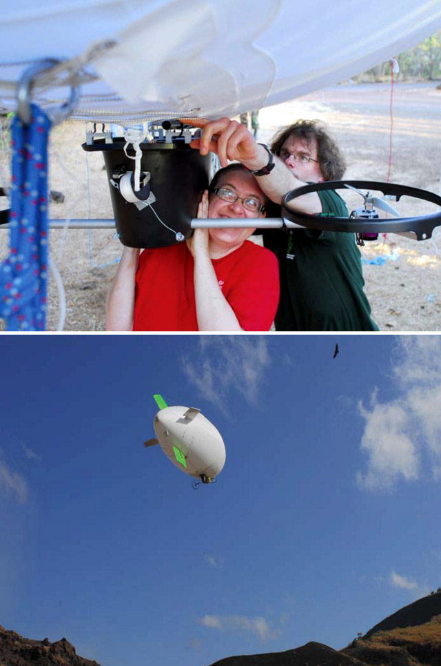
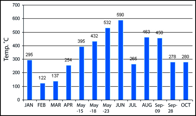
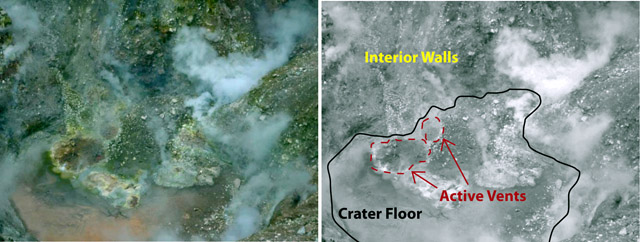
Intermittent sulfur dioxide plumes were detected using the TROPOMI instrument on the Sentinel-5P satellite, some of which exceeded at least two Dobson Units (DU) and drifted in different directions (figure 93). Occasional low-to-moderate power thermal anomalies were recorded by the MIROVA (Middle InfraRed Observation of Volcanic Activity) system; less than five anomalies were recorded each month during November 2022 through May 2023 (figure 94). Two thermal hotspots were detected by the MODVOLC thermal alerts system on 10 December 2022. On clear weather days, thermal activity was also captured in infrared satellite imagery in both the Main and South summit craters, accompanied by gas-and-steam emissions (figure 95).
Geologic Background. The 10-km-wide island of Manam, lying 13 km off the northern coast of mainland Papua New Guinea, is one of the country's most active volcanoes. Four large radial valleys extend from the unvegetated summit of the conical basaltic-andesitic stratovolcano to its lower flanks. These valleys channel lava flows and pyroclastic avalanches that have sometimes reached the coast. Five small satellitic centers are located near the island's shoreline on the northern, southern, and western sides. Two summit craters are present; both are active, although most observed eruptions have originated from the southern crater, concentrating eruptive products during much of the past century into the SE valley. Frequent eruptions, typically of mild-to-moderate scale, have been recorded since 1616. Occasional larger eruptions have produced pyroclastic flows and lava flows that reached flat-lying coastal areas and entered the sea, sometimes impacting populated areas.
Information Contacts: Rabaul Volcano Observatory (RVO), Geohazards Management Division, Department of Mineral Policy and Geohazards Management (DMPGM), PO Box 3386, Kokopo, East New Britain Province, Papua New Guinea; Darwin Volcanic Ash Advisory Centre (VAAC), Bureau of Meteorology, Northern Territory Regional Office, PO Box 40050, Casuarina, NT 0811, Australia (URL: http://www.bom.gov.au/info/vaac/); MIROVA (Middle InfraRed Observation of Volcanic Activity), a collaborative project between the Universities of Turin and Florence (Italy) supported by the Centre for Volcanic Risk of the Italian Civil Protection Department (URL: http://www.mirovaweb.it/); Hawai'i Institute of Geophysics and Planetology (HIGP) - MODVOLC Thermal Alerts System, School of Ocean and Earth Science and Technology (SOEST), Univ. of Hawai'i, 2525 Correa Road, Honolulu, HI 96822, USA (URL: http://modis.higp.hawaii.edu/); NASA Global Sulfur Dioxide Monitoring Page, Atmospheric Chemistry and Dynamics Laboratory, NASA Goddard Space Flight Center (NASA/GSFC), 8800 Greenbelt Road, Goddard, Maryland, USA (URL: https://so2.gsfc.nasa.gov/); Copernicus Browser, Copernicus Data Space Ecosystem, European Space Agency (URL: https://dataspace.copernicus.eu/browser/).
Krakatau (Indonesia) — July 2023 Cite this Report
Krakatau
Indonesia
6.1009°S, 105.4233°E; summit elev. 285 m
All times are local (unless otherwise noted)
Strombolian activity and ash plumes during November 2022-April 2023
Krakatau is located in the Sunda Strait between Java and Sumatra, Indonesia. Caldera collapse during the catastrophic 1883 eruption destroyed Danan and Perbuwatan cones and left only a remnant of Rakata. The post-collapse cone of Anak Krakatau (Child of Krakatau) was constructed within the 1883 caldera at a point between the former Danan and Perbuwatan cones; it has been the site of frequent eruptions since 1927. The current eruption period began in May 2021 and has recently consisted of explosions, ash plumes, and thermal activity (BGVN 47:11). This report covers activity during November 2022 through April 2023 based on information provided by the Indonesian Center for Volcanology and Geological Hazard Mitigation, referred to as Pusat Vulkanologi dan Mitigasi Bencana Geologi (PVMBG), MAGMA Indonesia, the Darwin Volcanic Ash Advisory Center (VAAC), and several sources of satellite data.
Activity was relatively low during November and December 2022. Daily white gas-and-steam plumes rose 25-100 m above the summit and drifted in different directions. Gray ash plumes rose 200 m above the summit and drifted NE at 1047 and at 2343 on 11 November. On 14 November at 0933 ash plumes rose 300 m above the summit and drifted E. An ash plume was reported at 0935 on 15 December that rose 100 m above the summit and drifted NE. An eruptive event at 1031 later that day generated an ash plume that rose 700 m above the summit and drifted NE. A gray ash plume at 1910 rose 100 m above the summit and drifted E. Incandescent material was ejected above the vent based on an image taken at 1936.
During January 2023 daily white gas-and-steam plumes rose 25-300 m above the summit and drifted in multiple directions. Gray-to-brown ash plumes were reported at 1638 on 3 January, at 1410 and 1509 on 4 January, and at 0013 on 5 January that rose 100-750 m above the summit and drifted NE and E; the gray-to-black ash plume at 1509 on 4 January rose as high as 3 km above the summit and drifted E. Gray ash plumes were recorded at 1754, 2241, and 2325 on 11 January and at 0046 on 12 January and rose 200-300 m above the summit and drifted NE. Toward the end of January, PVMBG reported that activity had intensified; Strombolian activity was visible in webcam images taken at 0041, 0043, and 0450 on 23 January. Multiple gray ash plumes throughout the day rose 200-500 m above the summit and drifted E and SE (figure 135). Webcam images showed progressively intensifying Strombolian activity at 1919, 1958, and 2113 on 24 January; a gray ash plume at 1957 rose 300 m above the summit and drifted E (figure 135). Eruptive events at 0231 and 2256 on 25 January and at 0003 on 26 January ejected incandescent material from the vent, based on webcam images. Gray ash plumes observed during 26-27 January rose 300-500 m above the summit and drifted NE, E, and SE.
Low levels of activity were reported during February and March. Daily white gas-and-steam plumes rose 25-300 m above the summit and drifted in different directions. The Darwin VAAC reported that continuous ash emissions rose to 1.5-1.8 km altitude and drifted W and NW during 1240-1300 on 10 March, based on satellite images, weather models, and PVMBG webcams. White-and-gray ash plumes rose 500 m and 300 m above the summit and drifted SW at 1446 and 1846 on 18 March, respectively. An eruptive event was recorded at 2143, though it was not visible due to darkness. Multiple ash plumes were reported during 27-29 March that rose as high as 2.5 km above the summit and drifted NE, W, and SW (figure 136). Webcam images captured incandescent ejecta above the vent at 0415 and around the summit area at 2003 on 28 March and at 0047 above the vent on 29 March.
Daily white gas-and-steam plumes rose 25-300 m above the summit and drifted in multiple directions during April and May. White-and-gray and black plumes rose 50-300 m above the summit on 2 and 9 April. On 11 May at 1241 a gray ash plume rose 1-3 km above the summit and drifted SW. On 12 May at 0920 a gray ash plume rose 2.5 km above the summit and drifted SW and at 2320 an ash plume rose 1.5 km above the summit and drifted SW. An accompanying webcam image showed incandescent ejecta. On 13 May at 0710 a gray ash plume rose 2 km above the summit and drifted SW (figure 137).
The MIROVA (Middle InfraRed Observation of Volcanic Activity) graph of MODIS thermal anomaly data showed intermittent low-to-moderate power thermal anomalies during November 2022 through April 2023 (figure 138). Some of this thermal activity was also visible in infrared satellite imagery at the crater, accompanied by gas-and-steam and ash plumes that drifted in different directions (figure 139).
Geologic Background. The renowned Krakatau (frequently mis-named as Krakatoa) volcano lies in the Sunda Strait between Java and Sumatra. Collapse of an older edifice, perhaps in 416 or 535 CE, formed a 7-km-wide caldera. Remnants of that volcano are preserved in Verlaten and Lang Islands; subsequently the Rakata, Danan, and Perbuwatan cones were formed, coalescing to create the pre-1883 Krakatau Island. Caldera collapse during the catastrophic 1883 eruption destroyed Danan and Perbuwatan, and left only a remnant of Rakata. This eruption caused more than 36,000 fatalities, most as a result of tsunamis that swept the adjacent coastlines of Sumatra and Java. Pyroclastic surges traveled 40 km across the Sunda Strait and reached the Sumatra coast. After a quiescence of less than a half century, the post-collapse cone of Anak Krakatau (Child of Krakatau) was constructed within the 1883 caldera at a point between the former Danan and Perbuwatan cones. Anak Krakatau has been the site of frequent eruptions since 1927.
Information Contacts: Pusat Vulkanologi dan Mitigasi Bencana Geologi (PVMBG, also known as Indonesian Center for Volcanology and Geological Hazard Mitigation, CVGHM), Jalan Diponegoro 57, Bandung 40122, Indonesia (URL: http://www.vsi.esdm.go.id/); MAGMA Indonesia, Kementerian Energi dan Sumber Daya Mineral (URL: https://magma.esdm.go.id/v1); Darwin Volcanic Ash Advisory Centre (VAAC), Bureau of Meteorology, Northern Territory Regional Office, PO Box 40050, Casuarina, NT 0811, Australia (URL: http://www.bom.gov.au/info/vaac/); MIROVA (Middle InfraRed Observation of Volcanic Activity), a collaborative project between the Universities of Turin and Florence (Italy) supported by the Centre for Volcanic Risk of the Italian Civil Protection Department (URL: http://www.mirovaweb.it/); Copernicus Browser, Copernicus Data Space Ecosystem, European Space Agency (URL: https://dataspace.copernicus.eu/browser/).
Stromboli
Italy
38.789°N, 15.213°E; summit elev. 924 m
All times are local (unless otherwise noted)
Strombolian explosions and lava flows continue during January-April 2023
Stromboli, located in Italy, has exhibited nearly constant lava fountains for the past 2,000 years; recorded eruptions date back to 350 BCE. Eruptive activity occurs at the summit from multiple vents, which include a north crater area (N area) and a central-southern crater (CS area) on a terrace known as the ‘terrazza craterica’ at the head of the Sciara del Fuoco, a large scarp that runs from the summit down the NW side of the volcano-island. Activity typically consists of Strombolian explosions, incandescent ejecta, lava flows, and pyroclastic flows. Thermal and visual monitoring cameras are located on the nearby Pizzo Sopra La Fossa, above the terrazza craterica, and at multiple flank locations. The current eruption period has been ongoing since 1934 and recent activity has consisted of frequent Strombolian explosions and lava flows (BGVN 48:02). This report updates activity during January through April 2023 primarily characterized by Strombolian explosions and lava flows based on reports from Italy's Istituto Nazionale di Geofisica e Vulcanologia (INGV) and various satellite data.
Frequent explosive activity continued throughout the reporting period, generally in the low-to-medium range, based on the number of hourly explosions in the summit crater (figure 253, table 16). Intermittent thermal activity was recorded by the MIROVA (Middle InfraRed Observation of Volcanic Activity) analysis of MODIS satellite data (figure 254). According to data collected by the MODVOLC thermal algorithm, a total of 9 thermal alerts were detected: one on 2 January 2023, one on 1 February, five on 24 March, and two on 26 March. The stronger pulses of thermal activity likely reflected lava flow events. Infrared satellite imagery captured relatively strong thermal hotspots at the two active summit craters on clear weather days, showing an especially strong event on 8 March (figure 255).
Table 16. Summary of type, frequency, and intensity of explosive activity at Stromboli by month during January-April 2023; information from webcam observations. Courtesy of INGV weekly reports.
| Month |
Explosive Activity |
| Jan 2023 |
Typical Strombolian activity with spattering and lava overflows in the N crater area. Explosions were reported from 4 vents in the N area and 1-2 vents in the CS area. The average hourly frequency of explosions was low-to-medium (1-12 events/hour). The intensity of the explosions varied from low (less than 80 m high) to medium (less than 150 m high) in the N crater area and up to high (greater than 150 m high) in the CS crater area. |
| Feb 2023 |
Typical Strombolian activity with spattering in the N crater area. Explosions were reported from 2-3 vents in the N area and 1-4 vents in the CS area. The average hourly frequency of explosions was low-to-medium (1-14 events/hour). The intensity of the explosions varied from low (less than 80 m high) to medium (less than 150 m high) in the N crater area and up to high (greater than 150 m high) in the CS crater area. |
| Mar 2023 |
Typical Strombolian activity with spattering and lava overflows in the N crater area. Explosions were reported from 2-3 vents in the N area and 2-4 vents in the CS area. The average hourly frequency of explosions was low-to-medium (1-18 events/hour). The intensity of the explosions varied from low (less than 80 m high) to medium (less than 150 m high) in the N crater area and up to high (greater than 150 m high) in the CS crater area. |
| Apr 2023 |
Typical Strombolian activity. Explosions were reported from 2 vents in the N area and 2-3 vents in the CS area. The average hourly frequency of explosions was low-to-high (1-16 events/hour). The intensity of the explosions varied from low (less than 80 m high) to medium (less than 150 m high) in both the N and CS crater areas. |
Activity during January-February 2023. Strombolian explosions were reported in the N crater area, as well as lava effusion. Explosive activity in the N crater area ejected coarse material (bombs and lapilli). Intense spattering was observed in both the N1 and N2 craters. In the CS crater area, explosions generally ejected fine material (ash), sometimes to heights greater than 250 m. The intensity of the explosions was characterized as low-to-medium in the N crater and medium-to-high in the CS crater. After intense spattering activity from the N crater area, a lava overflow began at 2136 on 2 January that flowed part way down the Sciara del Fuoco, possibly moving down the drainage that formed in October, out of view from webcams. The flow remained active for a couple of hours before stopping and beginning to cool. A second lava flow was reported at 0224 on 4 January that similarly remained active for a few hours before stopping and cooling. Intense spattering was observed on 11 and 13 January from the N1 crater. After intense spattering activity at the N2 crater at 1052 on 17 January another lava flow started to flow into the upper part of the Sciara del Fuoco (figure 256), dividing into two: one that traveled in the direction of the drainage formed in October, and the other one moving parallel to the point of emission. By the afternoon, the rate of the flow began to decrease, and at 1900 it started to cool. A lava flow was reported at 1519 on 24 January following intense spattering in the N2 area, which began to flow into the upper part of the Sciara del Fuoco. By the morning of 25 January, the lava flow had begun to cool. During 27 January the frequency of eruption in the CS crater area increased to 6-7 events/hour compared to the typical 1-7 events/hour; the following two days showed a decrease in frequency to less than 1 event/hour. Starting at 1007 on 30 January a high-energy explosive sequence was produced by vents in the CS crater area. The sequence began with an initial energetic pulse that lasted 45 seconds, ejecting predominantly coarse products 300 m above the crater that fell in an ESE direction. Subsequent and less intense explosions ejected material 100 m above the crater. The total duration of this event lasted approximately two minutes. During 31 January through 6, 13, and 24 February spattering activity was particularly intense for short periods in the N2 crater.
An explosive sequence was reported on 16 February that was characterized by a major explosion in the CS crater area (figure 257). The sequence began at 1817 near the S2 crater that ejected material radially. A few seconds later, lava fountains were observed in the central part of the crater. Three explosions of medium intensity (material was ejected less than 150 m high) were recorded at the S2 crater. The first part of this sequence lasted approximately one minute, according to INGV, and material rose 300 m above the crater and then was deposited along the Sciara del Fuoco. The second phase began at 1818 at the S1 crater; it lasted seven seconds and material was ejected 150 m above the crater. Another event 20 seconds later lasted 12 seconds, also ejecting material 150 m above the crater. The sequence ended with at least three explosions of mostly fine material from the S1 crater. The total duration of this sequence was about two minutes.
Short, intense spattering activity was noted above the N1 crater on 27 and 28 February. A lava overflow was first reported at 0657 from the N2 crater on 27 February that flowed into the October 2022 drainage. By 1900 the flow had stopped. A second lava overflow also in the N crater area occurred at 2149, which overlapped the first flow and then stopped by 0150 on 28 February. Material detached from both the lava overflows rolled down the Sciara del Fuoco, some of which was visible in webcam images.
Activity during March-April 2023. Strombolian activity continued with spattering activity and lava overflows in the N crater area during March. Explosive activity at the N crater area varied from low (less than 80 m high) to medium (less than 150 m high) and ejected coarse material, such as bombs and lapilli. Spattering was observed above the N1 crater, while explosive activity at the CS crater area varied from medium to high (greater than 150 m high) and ejected coarse material. Intense spattering activity was observed for short periods on 6 March above the N1 crater. At approximately 0610 a lava overflow was reported around the N2 crater on 8 March, which then flowed into the October 2022 drainage. By 1700 the flow started to cool. A second overflow began at 1712 on 9 March and overlapped the previous flow. It had stopped by 2100. Material from both flows was deposited along the Sciara del Fuoco, though much of the activity was not visible in webcam images. On 11 March a lava overflow was observed at 0215 that overlapped the two previous flows in the October 2022 drainage. By late afternoon on 12 March, it had stopped.
During a field excursion on 16 March, scientists noted that a vent in the central crater area was degassing. Another vent showed occasional Strombolian activity that emitted ash and lapilli. During 1200-1430 low-to-medium intense activity was reported; the N1 crater emitted ash emissions and the N2 crater emitted both ash and coarse material. Some explosions also occurred in the CS crater area that ejected coarse material. The C crater in the CS crater area occasionally showed gas jetting and low intensity explosions on 17 and 22 March; no activity was observed at the S1 crater. Intense, longer periods of spattering were reported in the N1 crater on 19, 24, and 25 March. Around 2242 on 23 March a lava overflow began from the N1 crater that, after about an hour, began moving down the October 2022 drainage and flow along the Sciara del Fuoco (figure 258). Between 0200 and 0400 on 26 March the flow rate increased, which generated avalanches of material from collapses at the advancing flow front. By early afternoon, the flow began to cool. On 25 March at 1548 an explosive sequence began from one of the vents at S2 in the CS crater area (figure 258). Fine ash mixed with coarse material was ejected 300 m above the crater rim and drifted SSE. Some modest explosions around Vent C were detected at 1549 on 25 March, which included an explosion at 1551 that ejected coarse material. The entire explosive sequence lasted approximately three minutes.
During April explosions persisted in both the N and CS crater areas. Fine material was ejected less than 80 m above the N crater rim until 6 April, followed by ejection of coarser material. Fine material was also ejected less than 80 m above the CS crater rim. The C and S2 crater did not show significant eruptive activity. On 7 April an explosive sequence was detected in the CS crater area at 1203 (figure 259). The first explosion lasted approximately 18 seconds and ejected material 400 m above the crater rim, depositing pyroclastic material in the upper part of the Sciara del Fuoco. At 1204 a second, less intense explosion lasted approximately four seconds and deposited pyroclastic products outside the crater area and near Pizzo Sopra La Fossa. A third explosion at 1205 was mainly composed of ash that rose about 150 m above the crater and lasted roughly 20 seconds. A fourth explosion occurred at 1205 about 28 seconds after the third explosion and ejected a mixture of coarse and fine material about 200 m above the crater; the explosion lasted roughly seven seconds. Overall, the entire explosive sequence lasted about two minutes and 20 seconds. After the explosive sequence on 7 April, explosions in both the N and CS crater areas ejected material as high as 150 m above the crater.
On 21 April research scientists from INGV made field observations in the summit area of Stromboli, and some lapilli samples were collected. In the N crater area near the N1 crater, a small cone was observed with at least two active vents, one of which was characterized by Strombolian explosions. The other vent produced explosions that ejected ash and chunks of cooled lava. At the N2 crater at least one vent was active and frequently emitted ash. In the CS crater area, a small cone contained 2-3 degassing vents and a smaller, possible fissure area also showed signs of degassing close to the Pizzo Sopra La Fossa. In the S part of the crater, three vents were active: a small hornito was characterized by modest and rare explosions, a vent that intermittently produced weak Strombolian explosions, and a vent at the end of the terrace that produced frequent ash emissions. Near the S1 crater there was a hornito that generally emitted weak gas-and-steam emissions, sometimes associated with “gas rings”. On 22 April another field inspection was carried out that reported two large sliding surfaces on the Sciara del Fuoco that showed where blocks frequently descended toward the sea. A thermal anomaly was detected at 0150 on 29 April.
Geologic Background. Spectacular incandescent nighttime explosions at Stromboli have long attracted visitors to the "Lighthouse of the Mediterranean" in the NE Aeolian Islands. This volcano has lent its name to the frequent mild explosive activity that has characterized its eruptions throughout much of historical time. The small island is the emergent summit of a volcano that grew in two main eruptive cycles, the last of which formed the western portion of the island. The Neostromboli eruptive period took place between about 13,000 and 5,000 years ago. The active summit vents are located at the head of the Sciara del Fuoco, a prominent scarp that formed about 5,000 years ago due to a series of slope failures which extends to below sea level. The modern volcano has been constructed within this scarp, which funnels pyroclastic ejecta and lava flows to the NW. Essentially continuous mild Strombolian explosions, sometimes accompanied by lava flows, have been recorded for more than a millennium.
Information Contacts: Istituto Nazionale di Geofisica e Vulcanologia (INGV), Sezione di Catania, Piazza Roma 2, 95123 Catania, Italy, (URL: http://www.ct.ingv.it/en/); MIROVA (Middle InfraRed Observation of Volcanic Activity), a collaborative project between the Universities of Turin and Florence (Italy) supported by the Centre for Volcanic Risk of the Italian Civil Protection Department (URL: http://www.mirovaweb.it/); Hawai'i Institute of Geophysics and Planetology (HIGP) - MODVOLC Thermal Alerts System, School of Ocean and Earth Science and Technology (SOEST), Univ. of Hawai'i, 2525 Correa Road, Honolulu, HI 96822, USA (URL: http://modis.higp.hawaii.edu/); Copernicus Browser, Copernicus Data Space Ecosystem, European Space Agency (URL: https://dataspace.copernicus.eu/browser/).
Nishinoshima (Japan) — July 2023 Cite this Report
Nishinoshima
Japan
27.247°N, 140.874°E; summit elev. 100 m
All times are local (unless otherwise noted)
Small ash plumes and fumarolic activity during November 2022 through April 2023
Nishinoshima is a small island located about 1,000 km S of Tokyo in the Ogasawara Arc in Japan. The island is the summit of a massive submarine volcano that has prominent peaks to the S, W, and NE. Eruptions date back to 1973; the most recent eruption period began in October 2022 and was characterized by ash plumes and fumarolic activity (BGVN 47:12). This report describes ash plumes and fumarolic activity during November 2022 through April 2023 based on monthly reports from the Japan Meteorological Agency (JMA) monthly reports and satellite data.
The most recent eruptive activity prior to the reporting internal occurred on 12 October 2022, when an ash plume rose 3.5 km above the crater rim. An aerial observation conducted by the Japan Coast Guard (JCG) on 25 November reported that white fumaroles rose approximately 200 m above the central crater of a pyroclastic cone (figure 119), and multiple plumes were observed on the ESE flank of the cone. Discolored water ranging from reddish-brown to brown and yellowish-green were visible around the perimeter of the island (figure 119). No significant activity was reported in December.
During an overflight conducted by JCG on 25 January 2023 intermittent activity and small, blackish-gray plumes rose 900 m above the central part of the crater were observed (figure 120). The fumarolic zone of the E flank and base of the cone had expanded and emissions had intensified. Dark brown discolored water was visible around the perimeter of the island.
No significant activity was reported during February through March. Ash plumes at 1050 and 1420 on 11 April rose 1.9 km above the crater rim and drifted NW and N. These were the first ash plumes observed since 12 October 2022. On 14 April JCG carried out an overflight and reported that no further eruptive activity was visible, although white gas-and-steam plumes were visible from the central crater and rose 900 m high (figure 121). Brownish and yellow-green discolored water surrounded the island.
Intermittent low-to-moderate power thermal anomalies were recorded in the MIROVA graph (Middle InfraRed Observation of Volcanic Activity) during November 2022 through April 2023 (figure 123). A cluster of six to eight anomalies were detected during November while a smaller number were detected during the following months: two to three during December, one during mid-January 2023, one during February, five during March, and two during April. Thermal activity was also reflected in infrared satellite data at the summit crater, accompanied by occasional gas-and-steam plumes (figure 124).
Geologic Background. The small island of Nishinoshima was enlarged when several new islands coalesced during an eruption in 1973-74. Multiple eruptions that began in 2013 completely covered the previous exposed surface and continued to enlarge the island. The island is the summit of a massive submarine volcano that has prominent peaks to the S, W, and NE. The summit of the southern cone rises to within 214 m of the ocean surface 9 km SSE.
Information Contacts: Japan Meteorological Agency (JMA), 1-3-4 Otemachi, Chiyoda-ku, Tokyo 100-8122, Japan (URL: http://www.jma.go.jp/jma/indexe.html); MIROVA (Middle InfraRed Observation of Volcanic Activity), a collaborative project between the Universities of Turin and Florence (Italy) supported by the Centre for Volcanic Risk of the Italian Civil Protection Department (URL: http://www.mirovaweb.it/); Copernicus Browser, Copernicus Data Space Ecosystem, European Space Agency (URL: https://dataspace.copernicus.eu/browser/).
Karangetang (Indonesia) — July 2023 Cite this Report
Karangetang
Indonesia
2.781°N, 125.407°E; summit elev. 1797 m
All times are local (unless otherwise noted)
Lava flows, incandescent avalanches, and ash plumes during January-June 2023
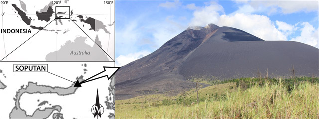
Karangetang (also known as Api Siau), at the northern end of the island of Siau, Indonesia, contains five summit craters along a N-S line. More than 40 eruptions have been recorded since 1675; recent eruptions have included frequent explosive activity, sometimes accompanied by pyroclastic flows and lahars. Lava dome growth has occurred in the summit craters and collapses of lava flow fronts have produced pyroclastic flows. The two active summit craters are Kawah Dua (the N crater) and Kawah Utama (the S crater, also referred to as the “Main Crater”). The most recent eruption began in late November 2018 and has more recently consisted of weak thermal activity and gas-and-steam emissions (BGVN 48:01). This report updates activity characterized by lava flows, incandescent avalanches, and ash plumes during January through June 2023 using reports from Pusat Vulkanologi dan Mitigasi Bencana Geologi (PVMBG, also known as CVGHM, or the Center of Volcanology and Geological Hazard Mitigation), MAGMA Indonesia, the Darwin VAAC (Volcano Ash Advisory Center), and satellite data.
Activity during January was relatively low and mainly consisted of white gas-and-steam emissions that rose 25-150 m above Main Crater (S crater) and drifted in different directions. Incandescence was visible from the lava dome in Kawah Dua (the N crater). Weather conditions often prevented clear views of the summit. On 18 January the number of seismic signals that indicated avalanches of material began to increase. In addition, there were a total of 71 earthquakes detected during the month.
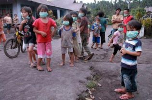
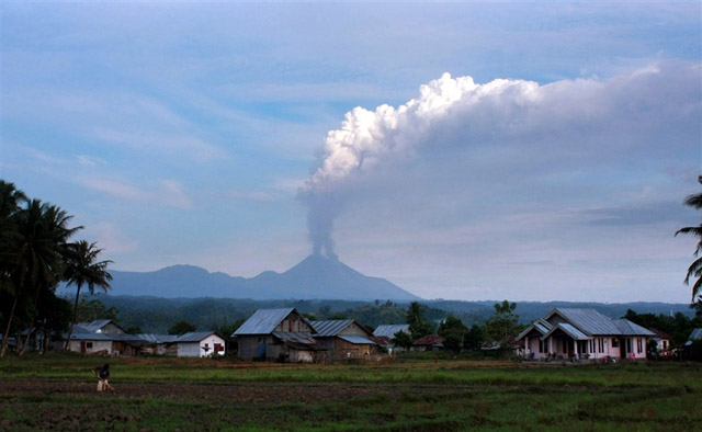
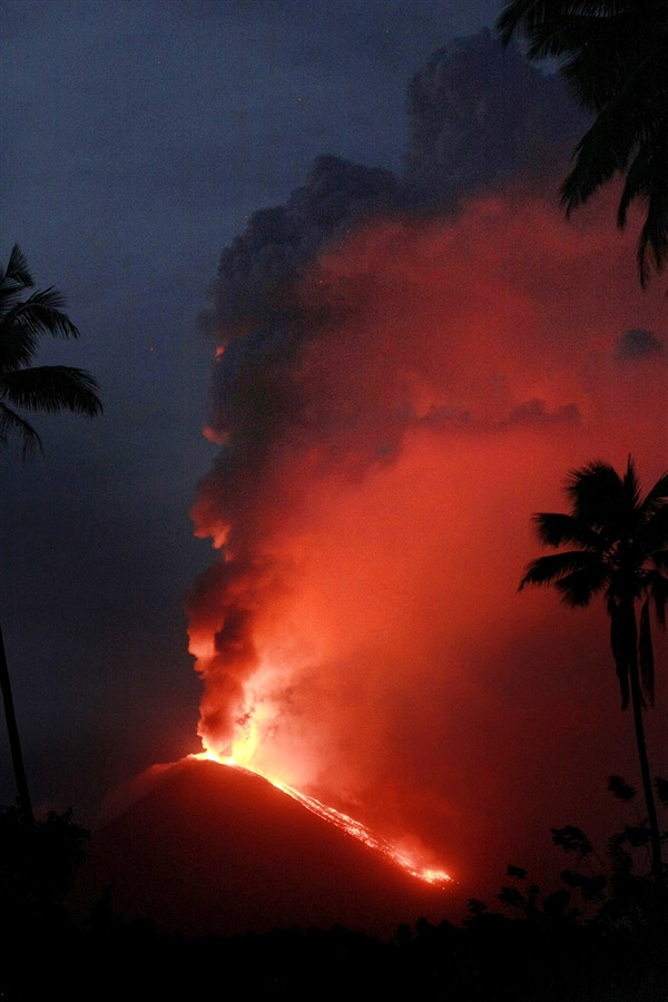
Activity continued to increase during the first week of February. Material from Main Crater traveled as far as 800 m down the Batuawang (S) and Batang (W) drainages and as far as 1 km W down the Beha (W) drainage on 4 February. On 6 February 43 earthquake events were recorded, and on 7 February, 62 events were recorded. White gas-and-steam emissions rose 25-250 m above both summit craters throughout the month. PVMBG reported an eruption began during the evening of 8 February around 1700. Photos showed incandescent material at Main Crater. Incandescent material had also descended the flank in at least two unconfirmed directions as far as 2 km from Main Crater, accompanied by ash plumes (figure 60). As a result, PVMBG increased the Volcano Alert Level (VAL) to 3 (the second highest level on a 1-4 scale).
Occasional nighttime webcam images showed three main incandescent lava flows of differing lengths traveling down the S, SW, and W flanks (figure 61). Incandescent rocks were visible on the upper flanks, possibly from ejected or collapsed material from the crater, and incandescence was the most intense at the summit. Based on analyses of satellite imagery and weather models, the Darwin VAAC reported that daily ash plumes during 16-20 February rose to 2.1-3 km altitude and drifted NNE, E, and SE. BNPB reported on 16 February that as many as 77 people were evacuated and relocated to the East Siau Museum. A webcam image taken at 2156 on 17 February possibly showed incandescent material descending the SE flank. Ash plumes rose to 2.1 km altitude and drifted SE during 22-23 February, according to the Darwin VAAC.
Incandescent avalanches of material and summit incandescence at Main Crater continued during March. White gas-and-steam emissions during March generally rose 25-150 m above the summit crater; on 31 March gas-and-steam emissions rose 200-400 m high. An ash plume rose to 2.4 km altitude and drifted S at 1710 on 9 March and a large thermal anomaly was visible in images taken at 0550 and 0930 on 10 March. Incandescent material was visible at the summit and on the flanks based on webcam images taken at 0007 and 2345 on 16 March, at 1828 on 17 March, at 1940 on 18 March, at 2311 on 19 March, and at 2351 on 20 March. Incandescence was most intense on 18 and 20 March and webcam images showed possible Strombolian explosions (figure 62). An ash plume rose to 2.4 km altitude and drifted SW on 18 March, accompanied by a thermal anomaly.
Summit crater incandescence at Main Crater and on the flanks persisted during April. Incandescent material at the S crater and on the flanks was reported at 0016 on 1 April. The lava flows had stopped by 1 April according to PVMBG, although incandescence was still visible up to 10 m high. Seismic signals indicating effusion decreased and by 6 April they were no longer detected. Incandescence was visible from both summit craters. On 26 April the VAL was lowered to 2 (the second lowest level on a 1-4 scale). White gas-and-steam emissions rose 25-200 m above the summit crater.
During May white gas-and-steam emissions generally rose 50-250 m above the summit, though it was often cloudy, which prevented clear views; on 21 May gas-and-steam emissions rose 50-400 m high. Nighttime N summit crater incandescence rose 10-25 m above the lava dome, and less intense incandescence was noted above Main Crater, which reached about 10 m above the dome. Sounds of falling rocks at Main Crater were heard on 15 May and the seismic network recorded 32 rockfall events in the crater on 17 May. Avalanches traveled as far as 1.5 km down the SW and S flanks, accompanied by rumbling sounds on 18 May. Incandescent material descending the flanks was captured in a webcam image at 2025 on 19 May (figure 63) and on 29 May; summit crater incandescence was observed in webcam images at 2332 on 26 May and at 2304 on 29 May. On 19 May the VAL was again raised to 3.
Occasional Main Crater incandescence was reported during June, as well as incandescent material on the flanks. White gas-and-steam emissions rose 10-200 m above the summit crater. Ash plumes rose to 2.1 km altitude and drifted SE and E during 2-4 June, according to the Darwin VAAC. Material on the flanks of Main Crater were observed at 2225 on 7 June, at 2051 on 9 June, at 0007 on 17 June, and at 0440 on 18 June. Webcam images taken on 21, 25, and 27 June showed incandescence at Main Crater and from material on the flanks.
MIROVA (Middle InfraRed Observation of Volcanic Activity) analysis of MODIS satellite data showed strong thermal activity during mid-February through March and mid-May through June, which represented incandescent avalanches and lava flows (figure 64). During April through mid-May the power of the anomalies decreased but frequent anomalies were still detected. Brief gaps in activity occurred during late March through early April and during mid-June. Infrared satellite images showed strong lava flows mainly affecting the SW and S flanks, accompanied by gas-and-steam emissions (figure 65). According to data recorded by the MODVOLC thermal algorithm, there were a total of 79 thermal hotspots detected: 28 during February, 24 during March, one during April, five during May, and 21 during June.
Geologic Background. Karangetang (Api Siau) volcano lies at the northern end of the island of Siau, about 125 km NNE of the NE-most point of Sulawesi. The stratovolcano contains five summit craters along a N-S line. It is one of Indonesia's most active volcanoes, with more than 40 eruptions recorded since 1675 and many additional small eruptions that were not documented (Neumann van Padang, 1951). Twentieth-century eruptions have included frequent explosive activity sometimes accompanied by pyroclastic flows and lahars. Lava dome growth has occurred in the summit craters; collapse of lava flow fronts have produced pyroclastic flows.
Information Contacts: Pusat Vulkanologi dan Mitigasi Bencana Geologi (PVMBG, also known as Indonesian Center for Volcanology and Geological Hazard Mitigation, CVGHM), Jalan Diponegoro 57, Bandung 40122, Indonesia (URL: http://www.vsi.esdm.go.id/); MAGMA Indonesia, Kementerian Energi dan Sumber Daya Mineral (URL: https://magma.esdm.go.id/v1); Badan Nasional Penanggulangan Bencana (BNPB), National Disaster Management Agency, Graha BNPB - Jl. Scout Kav.38, East Jakarta 13120, Indonesia (URL: http://www.bnpb.go.id/); Darwin Volcanic Ash Advisory Centre (VAAC), Bureau of Meteorology, Northern Territory Regional Office, PO Box 40050, Casuarina, NT 0811, Australia (URL: http://www.bom.gov.au/info/vaac/); MIROVA (Middle InfraRed Observation of Volcanic Activity), a collaborative project between the Universities of Turin and Florence (Italy) supported by the Centre for Volcanic Risk of the Italian Civil Protection Department (URL: http://www.mirovaweb.it/); Hawai'i Institute of Geophysics and Planetology (HIGP) - MODVOLC Thermal Alerts System, School of Ocean and Earth Science and Technology (SOEST), Univ. of Hawai'i, 2525 Correa Road, Honolulu, HI 96822, USA (URL: http://modis.higp.hawaii.edu/); Copernicus Browser, Copernicus Data Space Ecosystem, European Space Agency (URL: https://dataspace.copernicus.eu/browser/); IDN Times, Jl. Jend. Gatot Subroto Kav. 27 3rd Floor Kuningan, Jakarta, Indonesia 12950, Status of Karangetang Volcano in Sitaro Islands Increases (URL: https://sulsel.idntimes.com/news/indonesia/savi/status-gunung-api-karangetang-di-kepulauan-sitaro-meningkat?page=all).
Ahyi (United States) — July 2023 Cite this Report
Ahyi
United States
20.42°N, 145.03°E; summit elev. -75 m
All times are local (unless otherwise noted)
Intermittent hydroacoustic signals and discolored plumes during November 2022-June 2023
Ahyi seamount is a large, conical submarine volcano that rises to within 75 m of the ocean surface about 18 km SE of the island of Farallon de Pajaros in the Northern Marianas. The remote location of the seamount has made eruptions difficult to document, but seismic stations installed in the region confirmed an eruption in the vicinity in 2001. No new activity was detected until April-May 2014 when an eruption was detected by NOAA (National Oceanic and Atmospheric Administration) divers, hydroacoustic sensors, and seismic stations (BGVN 42:04). New activity was first detected on 15 November by hydroacoustic sensors that were consistent with submarine volcanic activity. This report covers activity during November 2022 through June 2023 based on daily and weekly reports from the US Geological Survey.
Starting in mid-October, hydroacoustic sensors at Wake Island (2.2 km E) recorded signals consistent with submarine volcanic activity, according to a report from the USGS issued on 15 November 2022. A combined analysis of the hydroacoustic signals and seismic stations located at Guam and Chichijima Island, Japan, suggested that the source of this activity was at or near the Ahyi seamount. After a re-analysis of a satellite image of the area that was captured on 6 November, USGS confirmed that there was no evidence of discoloration at the ocean surface. Few hydroacoustic and seismic signals continued through November, including on 18 November, which USGS suggested signified a decline or pause in unrest. A VONA (Volcano Observatory Notice for Aviation) reported that a discolored water plume was persistently visible in satellite data starting on 18 November (figure 6). Though clouds often obscured clear views of the volcano, another discolored water plume was captured in a satellite image on 26 November. The Aviation Color Code (ACC) was raised to Yellow (the second lowest level on a four-color scale) and the Volcano Alert Level (VAL) was raised to Advisory (the second lowest level on a four-level scale) on 29 November.
During December, occasional detections were recorded on the Wake Island hydrophone sensors and discolored water over the seamount remained visible. During 2-7, 10-12, and 16-31 December possible explosion signals were detected. A small area of discolored water was observed in high-resolution Sentinel-2 satellite images during 1-6 December (figure 7). High-resolution satellite images recorded discolored water plumes on 13 December that originated from the summit region; no observations indicated that activity breached the ocean surface. A possible underwater plume was visible in satellite images on 18 December, and during 19-20 December a definite but diffuse underwater plume located SSE from the main vent was reported. An underwater plume was visible in a satellite image taken on 26 December (figure 7).
Hydrophone sensors continued to detect signals consistent with possible explosions during 1-8 January 2023. USGS reported that the number of detections decreased during 4-5 January. The hydrophone sensors experienced a data outage that started at 0118 on 8 January and continued through 10 January, though according to USGS, possible explosions were recorded prior to the data outage and likely continued during the outage. A discolored water plume originating from the summit region was detected in a partly cloudy satellite image on 8 January. On 11-12 and 15-17 January possible explosion signals were recorded again. One small signal was detected during 22-23 January and several signals were recorded on 25 and 31 January. During 27-31 January a plume of discolored water was observed above the seamount in satellite imagery (figure 8).
Low levels of activity continued during February and March, based on data from pressure sensors on Wake Island. During 1 and 4-6 February activity was reported, and a submarine plume was observed on 4 February (figure 8). Possible explosion signals were detected during 7-8, 10, 13-14, and 24 February. During 1-2 and 3-5 March a plume of discolored water was observed in satellite imagery (figure 8). Almost continuous hydroacoustic signals were detected in remote pressure sensor data on Wake Island 2,270 km E from the volcano during 7-13 March. During 12-13 March water discoloration around the seamount was observed in satellite imagery, despite cloudy weather. By 14 March discolored water extended about 35 km, but no direction was noted. USGS reported that the continuous hydroacoustic signals detected during 13-14 March stopped abruptly on 14 March and no new detections were observed. Three 30 second hydroacoustic detections were reported during 17-19 March, but no activity was visible due to cloudy weather. A data outage was reported during 21-22 March, making pressure sensor data unavailable; a discolored water plume was, however, visible in satellite data. A possible underwater explosion signal was detected by pressure sensors at Wake Island on 26, 29, and 31 March, though the cause and origin of these events were unclear.
Similar low activity continued during April, May, and June. Several signals were detected during 1-3 April in pressure sensors at Wake Island. USGS suggested that these may be related to underwater explosions or earthquakes at the volcano, but no underwater plumes were visible in clear satellite images. The pressure sensors had data outages during 12-13 April and no data were recorded; no underwater plumes were visible in satellite images, although cloudy weather obscured most clear views. Eruptive activity was reported starting at 2210 on 21 May. On 22 May a discolored water plume that extended 4 km was visible in satellite images, though no direction was recorded. During 23-24 May some signals were detected by the underwater pressure sensors. Possible hydroacoustic signals were detected during 2-3 and 6-8 June. Multiple hydroacoustic signals were detected during 9-11 and 16-17 June, although no activity was visible in satellite images. One hydroacoustic signal was detected during 23-24 June, but there was some uncertainty about its association with volcanic activity. A single possible hydroacoustic signal was detected during 30 June to 1 July.
Geologic Background. Ahyi seamount is a large conical submarine volcano that rises to within 75 m of the ocean surface ~18 km SE of the island of Farallon de Pajaros in the northern Marianas. Water discoloration has been observed there, and in 1979 the crew of a fishing boat felt shocks over the summit area, followed by upwelling of sulfur-bearing water. On 24-25 April 2001 an explosive eruption was detected seismically by a station on Rangiroa Atoll, Tuamotu Archipelago. The event was well constrained (+/- 15 km) at a location near the southern base of Ahyi. An eruption in April-May 2014 was detected by NOAA divers, hydroacoustic sensors, and seismic stations.
Information Contacts: US Geological Survey, Volcano Hazards Program (USGS-VHP), 12201 Sunrise Valley Drive, Reston, VA, USA, https://volcanoes.usgs.gov/index.html; Copernicus Browser, Copernicus Data Space Ecosystem, European Space Agency (URL: https://dataspace.copernicus.eu/browser/).
Kadovar (Papua New Guinea) — June 2023 Cite this Report
Kadovar
Papua New Guinea
3.608°S, 144.588°E; summit elev. 365 m
All times are local (unless otherwise noted)
An ash plume and weak thermal anomaly during May 2023
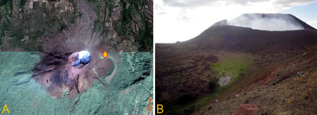
Kadovar is a 2-km-wide island that is the emergent summit of a Bismarck Sea stratovolcano. It lies off the coast of New Guinea, about 25 km N of the mouth of the Sepik River. Prior to an eruption that began in 2018, a lava dome formed the high point of the volcano, filling an arcuate landslide scarp open to the S. Submarine debris-avalanche deposits occur to the S of the island. The current eruption began in January 2018 and has comprised lava effusion from vents at the summit and at the E coast; more recent activity has consisted of ash plumes, weak thermal activity, and gas-and-steam plumes (BGVN 48:02). This report covers activity during February through May 2023 using information from the Darwin Volcanic Ash Advisory Center (VAAC) and satellite data.
Activity during the reporting period was relatively low and mainly consisted of white gas-and-steam plumes that were visible in natural color satellite images on clear weather days (figure 67). According to a Darwin VAAC report, at 2040 on 6 May an ash plume rose to 4.6 km altitude and drifted W; by 2300 the plume had dissipated. MODIS satellite instruments using the MODVOLC thermal algorithm detected a single thermal hotspot on the SE side of the island on 7 May. Weak thermal activity was also detected in a satellite image on the E side of the island on 14 May, accompanied by a white gas-and-steam plume that drifted SE (figure 68).
Geologic Background. The 2-km-wide island of Kadovar is the emergent summit of a Bismarck Sea stratovolcano of Holocene age. It is part of the Schouten Islands, and lies off the coast of New Guinea, about 25 km N of the mouth of the Sepik River. Prior to an eruption that began in 2018, a lava dome formed the high point of the andesitic volcano, filling an arcuate landslide scarp open to the south; submarine debris-avalanche deposits occur in that direction. Thick lava flows with columnar jointing forms low cliffs along the coast. The youthful island lacks fringing or offshore reefs. A period of heightened thermal phenomena took place in 1976. An eruption began in January 2018 that included lava effusion from vents at the summit and at the E coast.
Information Contacts: Darwin Volcanic Ash Advisory Centre (VAAC), Bureau of Meteorology, Northern Territory Regional Office, PO Box 40050, Casuarina, NT 0811, Australia (URL: http://www.bom.gov.au/info/vaac/); Hawai'i Institute of Geophysics and Planetology (HIGP) - MODVOLC Thermal Alerts System, School of Ocean and Earth Science and Technology (SOEST), Univ. of Hawai'i, 2525 Correa Road, Honolulu, HI 96822, USA (URL: http://modis.higp.hawaii.edu/); Copernicus Browser, Copernicus Data Space Ecosystem, European Space Agency (URL: https://dataspace.copernicus.eu/browser/).
San Miguel (El Salvador) — June 2023 Cite this Report
San Miguel
El Salvador
13.434°N, 88.269°W; summit elev. 2130 m
All times are local (unless otherwise noted)
Small gas-and-ash explosions during March and May 2023
San Miguel in El Salvador is a broad, deep crater complex that has been frequently modified by eruptions recorded since the early 16th century and consists of the summit known locally as Chaparrastique. Flank eruptions have produced lava flows that extended to the N, NE, and SE during the 17-19th centuries. The most recent activity has consisted of minor ash eruptions from the summit crater. The current eruption period began in November 2022 and has been characterized by frequent phreatic explosions, gas-and-ash emissions, and sulfur dioxide plumes (BGVN 47:12). This report describes small gas-and-ash explosions during December 2022 through May 2023 based on special reports from the Ministero de Medio Ambiente y Recursos Naturales (MARN).
Activity has been relatively low since the last recorded explosions on 29 November 2022. Seismicity recorded by the San Miguel Volcano Station (VSM) located on the N flank at 1.7 km elevation had decreased by 7 December. Sulfur dioxide gas measurements taken with DOAS (Differential Optical Absorption Spectroscopy) mobile equipment were below typical previously recorded values: 300 tons per day (t/d). During December, small explosions were recorded by the seismic network and manifested as gas-and-steam emissions.
Gas-and-ash explosions in the crater occurred during January 2023, which were recorded by the seismic network. Sulfur dioxide values remained low, between 300-400 t/d through 10 March. At 0817 on 14 January a gas-and-ash emission was visible in webcam images, rising just above the crater rim. Some mornings during February, small gas-and-steam plumes were visible in the crater. On 7 March at 2252 MARN noted an increase in degassing from the central crater; gas emissions were constantly observed through the early morning hours on 8 March. During the early morning of 8 March through the afternoon on 9 March, 12 emissions were registered, some accompanied by ash. The last gas-and-ash emission was recorded at 1210 on 9 March; very fine ashfall was reported in El Tránsito (10 km S), La Morita (6 km W), and La Piedrita (3 km W). The smell of sulfur was reported in Piedra Azul (5 km SW). On 16 March MARN reported that gas-and-steam emissions decreased.
Low degassing and very low seismicity were reported during April; no explosions have been detected between 9 March and 27 May. The sulfur dioxide emissions remained between 350-400 t/d; during 13-20 April sulfur dioxide values fluctuated between 30-300 t/d. Activity remained low through most of May; on 23 May seismicity increased. An explosion was detected at 1647 on 27 May generated a gas-and-ash plume that rose 700 m high (figure 32); a decrease in seismicity and gas emissions followed. The DOAS station installed on the W flank recorded sulfur dioxide values that reached 400 t/d on 27 May; subsequent measurements showed a decrease to 268 t/d on 28 May and 100 t/d on 29 May.
Geologic Background. The symmetrical cone of San Miguel, one of the most active volcanoes in El Salvador, rises from near sea level to form one of the country's most prominent landmarks. A broad, deep, crater complex that has been frequently modified by eruptions recorded since the early 16th century caps the truncated unvegetated summit, also known locally as Chaparrastique. Flanks eruptions of the basaltic-andesitic volcano have produced many lava flows, including several during the 17th-19th centuries that extended to the N, NE, and SE. The SE-flank flows are the largest and form broad, sparsely vegetated lava fields crossed by highways and a railroad skirting the base of the volcano. Flank vent locations have migrated higher on the edifice during historical time, and the most recent activity has consisted of minor ash eruptions from the summit crater.
Information Contacts: Ministero de Medio Ambiente y Recursos Naturales (MARN), Km. 5½ Carretera a Nueva San Salvador, Avenida las Mercedes, San Salvador, El Salvador (URL: http://www.snet.gob.sv/ver/vulcanologia).
Semisopochnoi (United States) — June 2023 Cite this Report
Semisopochnoi
United States
51.93°N, 179.58°E; summit elev. 1221 m
All times are local (unless otherwise noted)
Occasional explosions, ash deposits, and gas-and-steam plumes during December 2022-May 2023
Semisopochnoi is located in the western Aleutians, is 20-km-wide at sea level, and contains an 8-km-wide caldera. The three-peaked Mount Young (formerly Cerberus) was constructed within the caldera during the Holocene. Each of these peaks contains a summit crater; the lava flows on the N flank appear younger than those on the S side. The current eruption period began in early February 2021 and has more recently consisted of intermittent explosions and ash emissions (BGVN 47:12). This report updates activity during December 2022 through May 2023 using daily, weekly, and special reports from the Alaska Volcano Observatory (AVO). AVO monitors the volcano using local seismic and infrasound sensors, satellite data, web cameras, and remote infrasound and lightning networks.
Activity during most of December 2022 was relatively quiet; according to AVO no eruptive or explosive activity was observed since 7 November 2022. Intermittent tremor and occasional small earthquakes were observed in geophysical data. Continuous gas-and-steam emissions were observed from the N crater of Mount Young in webcam images on clear weather days (figure 25). On 24 December, there was a slight increase in earthquake activity and several small possible explosion signals were detected in infrasound data. Eruptive activity resumed on 27 December at the N crater of Mount Young; AVO issued a Volcano Activity Notice (VAN) that reported minor ash deposits on the flanks of Mount Young that extended as far as 1 km from the vent, according to webcam images taken during 27-28 December (figure 26). No ash plumes were observed in webcam or satellite imagery, but a persistent gas-and-steam plume that might have contained some ash rose to 1.5 km altitude. As a result, AVO raised the Aviation Color Code (ACC) to Orange (the second highest level on a four-color scale) and the Volcano Alert Level (VAL) to Watch (the second highest level on a four-level scale). Possible explosions were detected during 21 December 2022 through 1 January 2023 and seismic tremor was recorded during 30-31 December.
During January 2023 eruptive activity continued at the active N crater of Mount Young. Minor ash deposits were observed on the flanks, extending about 2 km SSW, based on webcam images from 1 and 3 January. A possible explosion occurred during 1-2 January based on elevated seismicity recorded on local seismometers and an infrasound signal recorded minutes later by an array at Adak. Though no ash plumes were observed in webcam or satellite imagery, a persistent gas-and-steam plume rose to 1.5 km altitude that might have carried minor traces of ash. Ash deposits were accompanied by periods of elevated seismicity and infrasound signals from the local geophysical network, which AVO reported were likely due to weak explosive activity. Low-level explosive activity was also detected during 2-3 January, with minor gas-and-steam emissions and a new ash deposit that was visible in webcam images. Low-level explosive activity was detected in geophysical data during 4-5 January, with elevated seismicity and infrasound signals observed on local stations. Volcanic tremor was detected during 7-9 January and very weak explosive activity was detected in seismic and infrasound data on 9 January. Weak seismic and infrasound signals were recorded on 17 January, which indicated minor explosive activity, but no ash emissions were observed in clear webcam images; a gas-and-steam plume continued to rise to 1.5 km altitude. During 29-30 January, ash deposits near the summit were observed on fresh snow, according to webcam images.
The active N cone at Mount Young continued to produce a gas-and-steam plume during February, but no ash emissions or explosive events were detected. Seismicity remained elevated with faint tremor during early February. Gas-and-steam emissions from the N crater were observed in clear webcam images on 11-13 and 16 February; no explosive activity was detected in seismic, infrasound, or satellite data. Seismicity has also decreased, with no significant seismic tremor observed since 25 January. Therefore, the ACC was lowered to Yellow (the second lowest level on a four-color scale) and the VAL was lowered to Advisory (the second lowest level on a four-color scale) on 22 February.
Gas-and-steam emissions persisted during March from the N cone of Mount Young, based on clear webcam images. A few brief episodes of weak tremor were detected in seismic data, although seismicity decreased over the month. A gas-and-steam plume detected in satellite data extended 150 km on 18 March. Low-level ash emissions from the N cone at Mount Young were observed in several webcam images during 18-19 March, in addition to small explosions and volcanic tremor. The ACC was raised to Orange and the VAL increased to Watch on 19 March. A small explosion was detected in seismic and infrasound data on 21 March.
Low-level unrest continued during April, although cloudy weather often obscured views of the summit; periods of seismic tremor and local earthquakes were recorded. During 3-4 April a gas-and-steam plume was visible traveling more than 200 km overnight; no ash was evident in the plume, according to AVO. A gas-and-steam plume was observed during 4-6 April that extended 400 km but did not seem to contain ash. Small explosions were detected in seismic and infrasound data on 5 April. Occasional clear webcam images showed continuing gas-and-steam emissions rose from Mount Young, but no ash deposits were observed on the snow. On 19 April small explosions and tremor were detected in seismic and infrasound data. A period of seismic tremor was detected during 22-25 April, with possible weak explosions on 25 April. Ash deposits were visible near the crater rim, but it was unclear if these deposits were recent or due to older deposits.
Occasional small earthquakes were recorded during May, but there were no signs of explosive activity seen in geophysical data. Gas-and-steam emissions continued from the N crater of Mount Young, based on webcam images, and seismicity remained slightly elevated. A new, light ash deposit was visible during the morning of 5 May on fresh snow on the NW flank of Mount Young. During 10 May periods of volcanic tremor were observed. The ACC was lowered to Yellow and the VAL to Advisory on 17 May due to no additional evidence of activity.
Geologic Background. Semisopochnoi, the largest subaerial volcano of the western Aleutians, is 20 km wide at sea level and contains an 8-km-wide caldera. It formed as a result of collapse of a low-angle, dominantly basaltic volcano following the eruption of a large volume of dacitic pumice. The high point of the island is Anvil Peak, a double-peaked late-Pleistocene cone that forms much of the island's northern part. The three-peaked Mount Cerberus (renamed Mount Young in 2023) was constructed within the caldera during the Holocene. Each of the peaks contains a summit crater; lava flows on the N flank appear younger than those on the south side. Other post-caldera volcanoes include the symmetrical Sugarloaf Peak SSE of the caldera and Lakeshore Cone, a small cinder cone at the edge of Fenner Lake in the NE part of the caldera. Most documented eruptions have originated from Young, although Coats (1950) considered that both Sugarloaf and Lakeshore Cone could have been recently active.
Information Contacts: Alaska Volcano Observatory (AVO), a cooperative program of a) U.S. Geological Survey, 4200 University Drive, Anchorage, AK 99508-4667 USA (URL: https://avo.alaska.edu/), b) Geophysical Institute, University of Alaska, PO Box 757320, Fairbanks, AK 99775-7320, USA, and c) Alaska Division of Geological & Geophysical Surveys, 794 University Ave., Suite 200, Fairbanks, AK 99709, USA (URL: http://dggs.alaska.gov/).
Ebeko
Russia
50.686°N, 156.014°E; summit elev. 1103 m
All times are local (unless otherwise noted)
Continued explosions, ash plumes, and ashfall during October 2022-May 2023
Ebeko, located on the N end of Paramushir Island in the Kuril Islands, consists of three summit craters along a SSW-NNE line at the northern end of a complex of five volcanic cones. Eruptions date back to the late 18th century and have been characterized as small-to-moderate explosions from the summit crater, accompanied by intense fumarolic activity. The current eruption period began in June 2022 and has recently consisted of frequent explosions, ash plumes, and thermal activity (BGVN 47:10). This report covers similar activity during October 2022 through May 2023, based on information from the Kamchatka Volcanic Eruptions Response Team (KVERT) and satellite data.
Activity during October consisted of explosive activity, ash plumes, and occasional thermal anomalies. Visual data by volcanologists from Severo-Kurilsk showed explosions producing ash clouds up to 2.1-3 km altitude which drifted E, N, NE, and SE during 1-8, 10, 16, and 18 October. KVERT issued several Volcano Observatory Notices for Aviation (VONA) on 7, 13-15, and 27 October 2022, stating that explosions generated ash plumes that rose to 2.3-4 km altitude and drifted 5 km E, NE, and SE. Ashfall was reported in Severo-Kurilsk (Paramushir Island, about 7 km E) on 7 and 13 October. Satellite data showed a thermal anomaly over the volcano on 15-16 October. Visual data showed ash plumes rising to 2.5-3.6 km altitude on 22, 25-29, and 31 October and moving NE due to constant explosions.
Similar activity continued during November, with explosions, ash plumes, and ashfall occurring. KVERT issued VONAs on 1-2, 4, 6-7, 9, 13, and 16 November that reported explosions and resulting ash plumes that rose to 1.7-3.6 km altitude and drifted 3-5 km SE, ESE, E, and NE. On 1 November ash plumes extended as far as 110 km SE. On 5, 8, 12, and 24-25 November explosions and ash plumes rose to 2-3.1 km altitude and drifted N and E. Ashfall was observed in Severo-Kurilsk on 7 and 16 November. A thermal anomaly was visible during 1-4, 16, and 20 November. Explosions during 26 November rose as high as 2.7 km altitude and drifted NE (figure 45).
Explosions and ash plumes continued to occur in December. During 1-2 and 4 December volcanologists from Severo-Kurilsk observed explosions that sent ash to 1.9-2.5 km altitude and drifted NE and SE (figure 46). VONAs were issued on 5, 9, and 16 December reporting that explosions generated ash plumes rising to 1.9 km, 2.6 km, and 2.4 km altitude and drifted 5 km SE, E, and NE, respectively. A thermal anomaly was visible in satellite imagery on 16 December. On 18 and 27-28 December explosions produced ash plumes that rose to 2.5 km altitude and drifted NE and SE. On 31 December an ash plume rose to 2 km altitude and drifted NE.
Explosions continued during January 2023, based on visual observations by volcanologists from Severo-Kurilsk. During 1-7 January explosions generated ash plumes that rose to 4 km altitude and drifted NE, E, W, and SE. According to VONAs issued by KVERT on 2, 4, 10, and 23 January, explosions produced ash plumes that rose to 2-4 km altitude and drifted 5 km N, NE, E, and ENE; the ash plume that rose to 4 km altitude occurred on 10 January (figure 47). Satellite data showed a thermal anomaly during 3-4, 10, 13, 16, 21, 22, and 31 January. KVERT reported that an ash cloud on 4 January moved 12 km NE. On 6 and 9-11 January explosions sent ash plumes to 4.5 km altitude and drifted W and ESE. On 13 January an ash plume rose to 3 km altitude and drifted SE. During 20-24 January ash plumes from explosions rose to 3.7 km altitude and drifted SE, N, and NE. On 21 January the ash plume drifted as far as 40 km NE. During 28-29 and 31 January and 1 February ash plumes rose to 4 km altitude and drifted NE.
During February, explosions, ash plumes, and ashfall were reported. During 1, 4-5 and 7-8 February explosions generated ash plumes that rose to 4.5 km altitude and drifted E and NE; ashfall was observed on 5 and 8 February. On 6 February an explosion produced an ash plume that rose to 3 km altitude and drifted 7 km E, causing ashfall in Severo-Kurilsk. A thermal anomaly was visible in satellite data on 8, 9, 13, and 21 February. Explosions on 9 and 12-13 February produced ash plumes that rose to 4 km altitude and drifted E and NE; the ash cloud on 12 February extended as far as 45 km E. On 22 February explosions sent ash to 3 km altitude that drifted E. During 24 and 26-27 February ash plumes rose to 4 km altitude and drifted E. On 28 February an explosion sent ash to 2.5-3 km altitude and drifted 5 km E; ashfall was observed in Severo-Kurilsk.
Activity continued during March; visual observations showed that explosions generated ash plumes that rose to 3.6 km altitude on 3, 5-7, and 9-12 March and drifted E, NE, and NW. Thermal anomalies were visible on 10, 13, and 29-30 March in satellite imagery. On 18, 21-23, 26, and 29-30 March explosions produced ash plumes that rose to 2.8 km altitude and drifted NE and E; the ash plumes during 22-23 March extended up to 76 km E. A VONA issued on 21 March reported an explosion that produced an ash plume that rose to 2.8 km altitude and drifted 5 km E. Another VONA issued on 23 March reported that satellite data showed an ash plume rising to 3 km altitude and drifted 14 km E.
Explosions during April continued to generate ash plumes. On 1 and 4 April an ash plume rose to 2.8-3.5 km altitude and drifted SE and NE. A thermal anomaly was visible in satellite imagery during 1-6 April. Satellite data showed ash plumes and clouds rising to 2-3 km altitude and drifting up to 12 km SW and E on 3 and 6 April (figure 48). KVERT issued VONAs on 3, 5, 14, 16 April describing explosions that produced ash plumes rising to 3 km, 3.5 km, 3.5 km, and 3 km altitude and drifting 5 km S, 5 km NE and SE, 72 km NNE, and 5 km NE, respectively. According to satellite data, the resulting ash cloud from the explosion on 14 April was 25 x 7 km in size and drifted 72-104 km NNE during 14-15 April. According to visual data by volcanologists from Severo-Kurilsk explosions sent ash up to 3.5 km altitude that drifted NE and E during 15-16, 22, 25-26, and 29 April.
The explosive eruption continued during May. Explosions during 3-4, 6-7, and 9-10 May generated ash plumes that rose to 4 km altitude and drifted SW and E. Satellite data showed a thermal anomaly on 3, 9, 13-14, and 24 May. During 12-16, 23-25, and 27-28 May ash plumes rose to 3.5 km altitude and drifted in different directions due to explosions. Two VONA notices were issued on 16 and 25 May, describing explosions that generated ash plumes rising to 3 km and 3.5 km altitude, respectively and extending 5 km E. The ash cloud on 25 May drifted 75 km SE.
Thermal activity in the summit crater, occasionally accompanied by ash plumes and ash deposits on the SE and E flanks due to frequent explosions, were visible in infrared and true color satellite images (figure 49).
Geologic Background. The flat-topped summit of the central cone of Ebeko volcano, one of the most active in the Kuril Islands, occupies the northern end of Paramushir Island. Three summit craters located along a SSW-NNE line form Ebeko volcano proper, at the northern end of a complex of five volcanic cones. Blocky lava flows extend west from Ebeko and SE from the neighboring Nezametnyi cone. The eastern part of the southern crater contains strong solfataras and a large boiling spring. The central crater is filled by a lake about 20 m deep whose shores are lined with steaming solfataras; the northern crater lies across a narrow, low barrier from the central crater and contains a small, cold crescentic lake. Historical activity, recorded since the late-18th century, has been restricted to small-to-moderate explosive eruptions from the summit craters. Intense fumarolic activity occurs in the summit craters, on the outer flanks of the cone, and in lateral explosion craters.
Information Contacts: Kamchatka Volcanic Eruptions Response Team (KVERT), Far Eastern Branch, Russian Academy of Sciences, 9 Piip Blvd., Petropavlovsk-Kamchatsky, 683006, Russia (URL: http://www.kscnet.ru/ivs/kvert/); MIROVA (Middle InfraRed Observation of Volcanic Activity), a collaborative project between the Universities of Turin and Florence (Italy) supported by the Centre for Volcanic Risk of the Italian Civil Protection Department (URL: http://www.mirovaweb.it/); Copernicus Browser, Copernicus Data Space Ecosystem, European Space Agency (URL: https://dataspace.copernicus.eu/browser/).
Home Reef
Tonga
18.992°S, 174.775°W; summit elev. -10 m
All times are local (unless otherwise noted)
Discolored plumes continued during November 2022-April 2023
Home Reef is a submarine volcano located in the central Tonga islands between Lateiki (Metis Shoal) and Late Island. The first recorded eruption occurred in the mid-19th century, when an ephemeral island formed. An eruption in 1984 produced a 12-km-high eruption plume, a large volume of floating pumice, and an ephemeral island 500 x 1,500 m wide, with cliffs 30-50 m high that enclosed a water-filled crater. Another island-forming eruption in 2006 produced widespread pumice rafts that drifted as far as Australia; by 2008 the island had eroded below sea level. The previous eruption occurred during October 2022 and was characterized by a new island-forming eruption, lava effusion, ash plumes, discolored water, and gas-and-steam plumes (BGVN 47:11). This report covers discolored water plumes during November 2022 through April 2023 using satellite data.
Discolored plumes continued during the reporting period and were observed in true color satellite images on clear weather days. Satellite images show light green-yellow discolored water extending W on 8 and 28 November 2022 (figure 31), and SW on 18 November. Light green-yellow plumes extended W on 3 December, S on 13 December, SW on 18 December, and W and S on 23 December (figure 31). On 12 January 2023 discolored green-yellow plumes extended to the NE, E, SE, and N. The plume moved SE on 17 January and NW on 22 January. Faint discolored water in February was visible moving NE on 1 February. A discolored plume extended NW on 8 and 28 March and NW on 13 March (figure 31). During April, clear weather showed green-blue discolored plumes moving S on 2 April, W on 7 April, and NE and S on 12 April. A strong green-yellow discolored plume extended E and NE on 22 April for several kilometers (figure 31).
Geologic Background. Home Reef, a submarine volcano midway between Metis Shoal and Late Island in the central Tonga islands, was first reported active in the mid-19th century, when an ephemeral island formed. An eruption in 1984 produced a 12-km-high eruption plume, large amounts of floating pumice, and an ephemeral 500 x 1,500 m island, with cliffs 30-50 m high that enclosed a water-filled crater. In 2006 an island-forming eruption produced widespread dacitic pumice rafts that drifted as far as Australia. Another island was built during a September-October 2022 eruption.
Information Contacts: Copernicus Browser, Copernicus Data Space Ecosystem, European Space Agency (URL: https://dataspace.copernicus.eu/browser/).
Ambae
Vanuatu
15.389°S, 167.835°E; summit elev. 1496 m
All times are local (unless otherwise noted)
New lava flow, ash plumes, and sulfur dioxide plumes during February-May 2023
Ambae, also known as Aoba, is a large basaltic shield volcano in Vanuatu. A broad pyroclastic cone containing three crater lakes (Manaro Ngoru, Voui, and Manaro Lakua) is located at the summit within the youngest of at least two nested calderas. Periodic phreatic and pyroclastic explosions have been reported since the 16th century. A large eruption more than 400 years ago resulted in a volcanic cone within the summit crater that is now filled by Lake Voui; the similarly sized Lake Manaro fills the western third of the caldera. The previous eruption ended in August 2022 that was characterized by gas-and-steam and ash emissions and explosions of wet tephra (BGVN 47:10). This report covers a new eruption during February through May 2023 that consisted of a new lava flow, ash plumes, and sulfur dioxide emissions, using information from the Vanuatu Meteorology and Geo-Hazards Department (VMGD) and satellite data.
During the reporting period, the Alert Level remained at a 2 (on a scale of 0-5), which has been in place since December 2021. Activity during October 2022 through March 2023 remained relatively low and mostly consisted of gas-and-steam emissions in Lake Voui. VMGD reported that at 1300 on 15 November a satellite image captured a strong amount of sulfur dioxide rising above the volcano (figure 99), and that seismicity slightly increased. The southern and northern part of the island reported a strong sulfur dioxide smell and heard explosions. On 20 February 2023 a gas-and-ash plume rose 1.3 km above the summit and drifted SSW, according to a webcam image (figure 100). Gas-and-steam and possibly ash emissions continued on 23 February and volcanic earthquakes were recorded by the seismic network.
During April, volcanic earthquakes and gas-and-steam and ash emissions were reported from the cone in Lake Voui. VMGD reported that activity increased during 5-7 April; high gas-and-steam and ash plumes were visible, accompanied by nighttime incandescence. According to a Wellington VAAC report, a low-level ash plume rose as high as 2.5 km above the summit and drifted W and SW on 5 April, based on satellite imagery. Reports in Saratamata stated that a dark ash plume drifted to the WSW, but no loud explosion was heard. Webcam images from 2100 showed incandescence above the crater and reflected in the clouds. According to an aerial survey, field observations, and satellite data, water was no longer present in the lake. A lava flow was reported effusing from the vent and traveling N into the dry Lake Voui, which lasted three days. The next morning at 0745 on 6 April a gas-and-steam and ash plume rose 5.4 km above the summit and drifted ESE, based on information from VMGD (figure 101). The Wellington VAAC also reported that light ashfall was observed on the island. Intermittent gas-and-steam and ash emissions were visible on 7 April, some of which rose to an estimated 3 km above the summit and drifted E. Webcam images during 0107-0730 on 7 April showed continuing ash emissions. A gas-and-steam and ash plume rose 695 m above the summit crater at 0730 on 19 April and drifted ESE, based on a webcam image (figure 102).
According to visual and infrared satellite data, water was visible in Lake Voui as late as 24 March 2023 (figure 103). The vent in the caldera showed a gas-and-steam plume drifted SE. On 3 April thermal activity was first detected, accompanied by a gas-and-ash plume that drifted W (figure 103). The lava flow moved N within the dry lake and was shown cooling by 8 April. By 23 April much of the water in the lake had returned. Occasional sulfur dioxide plumes were detected by the TROPOMI instrument on the Sentinel-5P satellite that exceeded 2 Dobson Units (DU) and drifted in different directions (figure 104).
Geologic Background. The island of Ambae, also known as Aoba, is a massive 2,500 km3 basaltic shield that is the most voluminous volcano of the New Hebrides archipelago. A pronounced NE-SW-trending rift zone with numerous scoria cones gives the 16 x 38 km island an elongated form. A broad pyroclastic cone containing three crater lakes (Manaro Ngoru, Voui, and Manaro Lakua) is located at the summit within the youngest of at least two nested calderas, the largest of which is 6 km in diameter. That large central edifice is also called Manaro Voui or Lombenben volcano. Post-caldera explosive eruptions formed the summit craters about 360 years ago. A tuff cone was constructed within Lake Voui (or Vui) about 60 years later. The latest known flank eruption, about 300 years ago, destroyed the population of the Nduindui area near the western coast.
Information Contacts: Geo-Hazards Division, Vanuatu Meteorology and Geo-Hazards Department (VMGD), Ministry of Climate Change Adaptation, Meteorology, Geo-Hazards, Energy, Environment and Disaster Management, Private Mail Bag 9054, Lini Highway, Port Vila, Vanuatu (URL: http://www.vmgd.gov.vu/, https://www.facebook.com/VanuatuGeohazardsObservatory/); Wellington Volcanic Ash Advisory Centre (VAAC), Meteorological Service of New Zealand Ltd (MetService), PO Box 722, Wellington, New Zealand (URL: http://www.metservice.com/vaac/, http://www.ssd.noaa.gov/VAAC/OTH/NZ/messages.html); MIROVA (Middle InfraRed Observation of Volcanic Activity), a collaborative project between the Universities of Turin and Florence (Italy) supported by the Centre for Volcanic Risk of the Italian Civil Protection Department (URL: http://www.mirovaweb.it/); Global Sulfur Dioxide Monitoring Page, Atmospheric Chemistry and Dynamics Laboratory, NASA Goddard Space Flight Center (NASA/GSFC), 8800 Greenbelt Road, Goddard, Maryland, USA (URL: https://so2.gsfc.nasa.gov/); Copernicus Browser, Copernicus Data Space Ecosystem, European Space Agency (URL: https://dataspace.copernicus.eu/browser/).
Search Bulletin Archive by Publication Date
Select a month and year from the drop-downs and click "Show Issue" to have that issue displayed in this tab.
The default month and year is the latest issue available.
Bulletin of the Global Volcanism Network - Volume 36, Number 11 (November 2011)
Managing Editor: Richard Wunderman
Additional Reports (Unknown)
Tonga: Material of uncertain origin seen on 13 April 2011
Chaiten (Chile)
Declining vigor; magma ascent rate; disaster recovery in the town of Chaitén
Katla (Iceland)
Jökulhlaup and elevated seismicity in 2011; filming sparks eruption fears
Lokon-Empung (Indonesia)
Ongoing minor ash-bearing eruptions through at least November 2011
Masaya (Nicaragua)
Degassing through at least mid-2011; episodic crater wall collapse
Pinatubo (Philippines)
Hardships and economic impact of the 1991 eruption
Popocatepetl (Mexico)
Seismicity and small ash plumes continue through December 2011
Soputan (Indonesia)
Eruptions in July and August 2011
Telica (Nicaragua)
Degassing in 2011; seismic crisis leading to explosive eruption in May 2011
Zubair Group (Yemen)
December 2011 submarine eruption spotted by fishermen; island emerges
Additional Reports (Unknown) — November 2011 Cite this Report
Additional Reports
Unknown
Unknown, Unknown; summit elev. m
All times are local (unless otherwise noted)
Tonga: Material of uncertain origin seen on 13 April 2011
Based on inspection of a photo taken on 13 April 2011 from the International Space Station of Tofua volcano (Tonga), it appeared that possible pumice rafts were floating near the island (BGVN 36:09). However, the source of the material was unknown.
The source, extent, and makeup of the material remains uncertain. Inquiries sent to Mark Belvedere and others in Tonga in late 2011 failed to identify any mariners or other observers who recall seeing either an eruption or material floating on the sea surface around March to April 2011.
If the rafts drifted from the Tongan region, as they have often done in the past, they may have originated from an eruption at one of the volcanoes of the Ha'apai and Vava'u Groups. Some of those, such as Late, Home Reef, Metis Shoal, and Falcon Island, have erupted frequently, with pumice rafts and emergent ephemeral islands (figure 2).
Figure 2 came from a similar report in 1979, but in that (very different) case the initial problem was four active eruptive sources, any of which might explain the streaks and rafts of floating pumice drifting NE. The resulting uncertainty then revolved around which of those sources produced the bulk of the floating pumice (SEAN 04:06; Anonymous, 1979). Discovery of a large ephemeral island at Metis Shoal pointed to that as the primary source of the pumice rafts (SEAN 04:07 and 04:12).
NASA initiative and findings. Childs and others (2011), Chojnacki and others (2011), and Honaker and Childs (2011) point out the very practical goal of a "more timely warning system to divert maritime vessels from affected areas." They discussed the spectral signature of several pumice rafts from a remote-sensing perspective. They assessed the date of eruption onset, the volcano's name, coordinates, and the favored satellites to detect and track these rafts in their different environments.
For the limited cases they tested, MODIS best detected large scale pumice rafts and monitored them over time. Landsat 5, 7 and ALI best detected small rafts, especially in closed bodies of water such as lakes. The false-color composite improved the contrast of pumice rafts for visual identification. Thermal anomalies occurred over several large pumice rafts. They found a subpixel classification extremely effective at automatically identifying small areas of pumice.
Note that, for the case at hand, the authors did not know of or analyze the material on the sea surface.
References. Anonymous, 1979, Geophysical Events: Eos, Transactions, American Geophys. Union, 21 Aug 1079, p. 625.
Childs, LM, Chojnacki, PR, Coady, C., Geddes, Q, Honaker, LB, Lyddane, W, McGilloway, J, Scott, J, 2011, Pacific Ocean Disasters - Enhanced Detection and Monitoring of Pumice Rafts Using NASA EOS; Eos, Transaction of the Am. Geophys. Union, V44C-04; (URL: http://www.agu.org/meetings/)
Chojnacki, P, Lyddane, W, McGilloway, J, Geddes, Q, Honaker, L, Coady, C, and Scott, J, 2011, Implementing NASA Remote Sensing to Protect and Monitor our Waterways, [ley DEVELOP Team 5, posted 10 August 2011 in DEVELOP Virtual Poster Session with written transcript] Earthzine (URL: http://www.earthzine.org/2011/08/10/implementing-nasa-remote-sensing-to-protect-and-monitor-our-waterways/, https://www.youtube.com/watch?feature=player_embedded&v=sdTZFq8Kpg4).
Honaker, LB, Childs, L, 2011, Remote Sensing Monitoring of Pumice Rafts in the Pacific Ocean (URL: http://www.nianet.org/NIA/media/photo-gallery/Remote-Sensing-Monitoring-of-Pumice-Rafts-in-the-Pacific-Ocean.pdf).
Geologic Background. Reports of floating pumice from an unknown source, hydroacoustic signals, or possible eruption plumes seen in satellite imagery.
Information Contacts: Mark Belvedere, Treasure Island Eueiki Eco Resort, Vava'u, Tonga.
Chaiten
Chile
42.8349°S, 72.6514°W; summit elev. 1122 m
All times are local (unless otherwise noted)
Declining vigor; magma ascent rate; disaster recovery in the town of Chaitén
The previous report on Chaitén volcano, Chile (BGVN 35:12) noted that a second new lava dome was reported on 4 November 2008. The Alert Level remained at Red (the highest of the alert level system) from the onset of the eruption on 2 May 2008 through April 2010. This report will chronologically summarize the growth of the new lava domes and major eruptive events. In general, a gradual decline in activity occurred during November 2008-September 2011. The Alert Level stood at Yellow during May 2010-May 2011, and was then lowered to Green, where it remained through the end of 2011. Most of the information in this report comes from weekly to monthly reports from the Observatorio Volcanológico de los Andes del Sur-Servicio Nacional de Geología y Minería (OVDAS-SERNAGEOMIN) with collaboration from the Oficina Nacional de Emergencia - Ministerio del Interior (ONEMI). Finally, the current status of the town of Chaitén (which was abandoned by all but a handful of residents who continued to live there without electricity or running water) will be discussed. The potential hazards from dome-collapse-generated block-and-ash flows and lahars from remobilized volcanic deposits were persistent throughout the reporting period.
Portions of this report were initially synthesized and edited by Nick Legg (covering November 2008-March 2009) and Eduardo Guerrero (covering April 2009-July 2009), as part of a graduate student writing assignment in a volcanology class at Oregon State University under the guidance of professor Shan de Silva.
New lava domes observed. Initially occupying the caldera of Chaitén was the lava dome ('old dome') that existed prior to the 2 May 2008 eruption (and for the ~ 9,400 years since the previous eruption). A lava dome ('Dome 1') first observed on 21 May 2008 and a new lava dome ('Dome 2') confirmed on 4 November 2008 during an overflight (BGVN 35:12) were extruded on top of the old dome (figures 22 and 23). A third phase of dome extrusion ('Dome 3') was observed on 29 September 2009.
November 2008-April 2010 (Red Alert). Following the confirmation of the existence of Dome 2 on 4 November 2008, a lateral explosion occurred on 17 November, directed WSW. The explosion was not constrained to either Dome 1 or 2 alone, but was associated with a collapse resulting from continued dome extrusion. By 6 December 2008, both active domes had exceed the height of the caldera rim (Dome 1 by ~ 250 m and Dome 2 by ~ 350 m). SERNAGEOMIN reported an increase in the growth of Dome 2, corresponding to a temporally slight increase in both hybrid (HB) and volcano-tectonic (VT) earthquakes.
Plumes continued to vary in color, indicating varying contributions of steam and ash from both new domes. By 9 January 2009, an observational overflight revealed that the inner caldera had been filled by Domes 1 and 2, and growth of sharp spines or pinnacles was reported.
On 19 January, a major collapse of the Dome 2 summit spines occurred, producing block-and-ash flows that traveled down the SE and E flanks of Chaitén. After the collapse, observers noted a decrease in seismicity and slowed dome extrusion.
During a flyby facilitated by ONEMI and the Chilean Air Force on 21 January 2009, researchers from the University at Buffalo-State University of New York (UB-SUNY) and the University of Chile acquired thermal images of the dome complex (figure 24). The thermal images indicated that, while Dome 1 still had areas of elevated temperature, the highest temperatures (greater than 150°C) corresponded to the pinnacles at the summit of Dome 2 (figure 24a). Images of pyroclastic flow and rockfall deposits resting within the E part of the caldera disclosed elevated temperatures there as well (higher than 80°C in places, figure 24b). Their research on thermal imaging of Chaitén will be showcased in an upcoming publication.
By 9 February 2009, a new high-standing pinnacle atop Dome 2 indicated the return of rapid dome growth. This did not coincide with significant increases in seismicity.
On 19 February, a large partial collapse generated pyroclastic flows that traveled down the Chaitén River towards the town of Chaitén (see annotated photo below). This event produced a plume reaching 9.1 km altitude according to the Buenos Aires Volcanic Ash Advisory Center (VAAC). The plume was white (indicating high water vapor content) at the top, and contained abundant ash at the base. The collapse created a scarp measuring approximately 500 m by 500 m. Increased seismicity occurred on the same day; background volcanic tremor occurred from 1028 until 1346, and swarms of earthquakes ranging from M 3.6-4.2 originated at depths of 3-5 km. Due to the amount of material deposited from the collapse (~10 x 106 m3), SERNAGEOMIN reported a significantly higher than normal danger of lahars.
On 25 February 2009, dome growth focused on Dome 1, although seismicity had gradually decreased in frequency (excluding the outstanding events of mid-February discussed above) compared to November-December 2008 values. Despite the decrease, on the afternoon of 3 March, dome collapses occurred every ~ 40 minutes. Within the next few days, SERNAGEOMIN reported that "VT's almost disappeared." A gradual decrease in seismicity continued until 24 March, when the frequency of HB earthquakes increased briefly, but they decreased again by early April.
On 6 April, a prominent spine of lava was observed on the S part of Dome 1 (figure 25). It indicated that dome growth was still concentrated in the W part of the caldera (Dome 1). The next week, the same spine was reported to have a wider base, and the crater reportedly glowed at night. In early May, an aerial photograph captured a close view of a very fractured central lava spine of the dome complex (figure 26).
In the later parts of May 2009, dome growth and seismicity continued to be focused on the W part of the caldera, associated with Dome 1. Although there was no significant increase in seismicity until a slight increase in June, witnesses in the town of Chaitén reporting feeling tremors in May. Otherwise, activity through August consisted of continuous ash-and-steam emissions, small collapses of unstable portions of the domes, and resulting block-and-ash flows. Seasonal precipitation remobilized previously erupted material and lahars reached the town in July.
Seismicity remained slightly elevated (relative to April and May) through September. On 14 September, a surveillance camera captured a plume as wide as the caldera reaching ~ 1.5 km high. This plume was significantly wider than plumes in the previous months. On 29 September, witness reports prompted SERNAGEOMIN to fly past the caldera, and obervers saw evidence of a significant recent collapse.
SERNAGEOMIN's 29 September observation flight provided stunning views of the dome complex leading to the detection of a new dome, Dome 3, that had filled the 19 February 2009 collapse scar (figures 27 and 28). Dome 3 had a depression in its N sector and small central pinnacles (figure 28). The central pinnacle of the whole complex had disappeared, and a large active depression, elongated to the NNW, had formed E of Dome 3. This depression reportedly resulted from either a lateral explosion or a relatively slow and structurally controlled internal collapse.
Following the events of September, no major outstanding activity was reported through the rest of 2009. In late January 2010, two new telemetered seismic stations were added to the monitoring network, increasing the number of seismic stations around Chaitén to ten. A new observation camera was also installed ~ 800 m from the dome complex.
During the end of 2009 and January 2010, the growth rate of the dome complex slowed, and seismicity declined significantly, with larger earthquakes (stronger than M 3.5) being absent through at least March (figure 29). Following a few months of relatively calmer activity at Chaitén, and after at least a month without emissions of ash, the Alert Level was lowered to Yellow on 1 May 2010.
1 May 2010-2 May 2011 (Yellow Alert). During the period of Yellow Alert, reported plume heights remained below 2.1 km altitude (Buenos Aires VAAC); compared to the prior, more active period when plumes regularly reached 3-4 km in height, this was a significant decline. Over this period, the Buenos Aires VAAC reported occasional emissions that included ash (table 2). OVDAS-SERNAGEOMIN began recording mainly VT events (interpreted as relating to rock fracturing) and long period (LP) events (interpreted as related to fluid dynamics in and beneath the volcanic edifice). Both types of seismicity remained low throughout the remainder of 2010 and into 2011. However, incandescence of the lava dome surface was observed at night in late January 2011.
Table 2. Emissions from Chaitén's lava dome complex during the period of Yellow Alert (1 May 2010-2 May 2011); '--' indicates information that was not reported. Courtesy of the Buenos Aires VAAC.
| Date |
Altitude |
Drift distance |
Drift direction |
| 14 May 2010 |
1.8 km |
-- |
NE |
| 24 Jul 2010 |
-- |
70 km |
SSE |
| 30 Jul 2010 |
-- |
20 km |
NNE |
| 30 Jul 2010 |
-- |
45 km |
ESE |
| 21 Oct 2010 |
2.1 km |
-- |
ENE |
| 04 Nov 2010 |
1.8 km |
25 km |
NE |
| 13 Nov 2010 |
1.5 km |
40 km |
SE |
| 15 Nov 2010 |
1.8-2.1 km |
-- |
E |
3 May 2011-September 2011 (Green Alert). On 2 May 2011, the Alert Level was lowered to Green due to lower levels of activity since January 2011, including (1) seismicity remaining at low levels of occurrence and magnitude; (2) no significant emissions of ash; (3) a lack of dome growth and associated partial collapses; and (4) a lack of visual observations suggesting restlessness.
Since 3 May 2011, ash-free plumes rose no higher than 0.5 km; the exception was one plume in late May or early June. Seismicity remained low, with daily counts averaging fewer than 2 for LP events, less than 10 for VT events, and less than 1 for HB events.
Magma ascent prior to 2 May 2008 eruption. Wicks and others (2011) stated that "Because of the historically rare and explosive nature of rhyolite eruptions and because of the surprisingly short warning before the eruption of the Chaitén volcano, any information about the workings of the magmatic system at Chaitén, and rhyolitic systems in general, is important from both the scientific and hazard perspectives." There were only about 24 hours between the first felt seismicity in the town of Chaitén and the onset of the eruption. Such a short precursory period has been recorded for basaltic eruptions (e.g. Hekla volcano, Iceland; Soosalu and Einarsson, 2002), but not for silicic eruptions such as Chaitén (Castro and Dingwell, 2009).
Castro and Dingwell (2009) used petrological experiments to constrain the temperatures and decompression rates of the magma erupted explosively at Chaitén on 2 May 2008. Their results suggested that the magma rose from depths of at least 5 km in about four hours, shorter than the roughly 1-day period of seismicity that was felt in the town of Chaitén.
Wicks and others (2011) interpreted radar interferometry observations to indicate that the rapid ascent (as reported by Castro and Dingwell, 2009) of the Chaitén magma was controlled by pre-existing faults in the crust beneath Chile (figure 30). Specifically, they modeled a large, dipping, sill-like body (their "reservoir") residing under Minchinmávida volcano (~ 20 km E of Chaitén, "M" on figure 30) and rising towards the surface to the W of Chaitén (Morro Vilcún, "MV" on figure 30). The magma followed a path that intersected an inferred vertical conduit feeding Chaitén. They interpreted the rhyolitic reservoir as originating from either 1) a combination of tectonic stresses and magmatic overpressure draining rhyolitic magma from a mafic reservoir beneath Minchinmávida, or 2) an event similar to the M 9.5, 1960 Chilean earthquake creating permeability and a pressure gradient, allowing the overpressured magma to migrate to beneath Chaitén.
Restoring the town and damaged infrastructure. On 9 April 2011, the Chilean government reported that President Sebastián Piñera had announced the "North Chaitén Solution" plan. After restoring basic services (e.g. electricity) to the town of Chaitén in the first months of 2011, President Piñera stated that "everything will be definitively restored, electricity and light has already returned and ... all of the electricity poles are new." He also announced plans to dredge the harbor a second time (necessary due to the amount of remobilized volcanic material deposited in the bay) to allow boats to dock, a plan to install a floating dock, ongoing surveying for new paved roads to other surrounding cities, and plans for the town's school and aerodome.
References. Castro, J.M., and Dingwell, D.B., 2009, Rapid ascent of rhyolitic magma at Chaitén volcano, Chile: Nature, v. 461, p. 780-784 (DOI:10.1038/nature08458).
Soosalu, H., and Einarsson, P., 2002, Earthquake activity related to the 1991 eruption of the Hekla volcano, Iceland: Bulletin of Volcanology, v. 63, p. 536-544.
Wicks, C., de la Llera, J.C., Lara., L.E., and Lowenstern, J., 2011, The role of dyking and fault control in the rapid onset of eruption at Chaitén volcano, Chile, Nature, v. 478, pp. 374-377 (DOI:10.1038/nature10541).
Geologic Background. Chaitén is a small caldera (~3 km in diameter) located 10 km NE of the town of Chaitén on the Gulf of Corcovado. Multiple explosive eruptions throughout the Holocene have been identified. A rhyolitic obsidian lava dome occupies much of the caldera floor. Obsidian cobbles from this dome found in the Blanco River are the source of artifacts from archaeological sites along the Pacific coast as far as 400 km from the volcano to the N and S. The caldera is breached on the SW side by a river that drains to the bay of Chaitén. The first recorded eruption, beginning in 2008, produced major rhyolitic explosive activity and building a new dome and tephra cone on the older rhyolite dome.
Information Contacts: Observatorio Volcanológico de los Andes del Sur-Servico Nacional de Geologia y Mineria (OVDAS-SERNAGEOMIN), Avda Sta María No. 0104, Santiago, Chile (URL: http://www.sernageomin.cl/); Oficina Nacional de Emergencia - Ministerio del Interior (ONEMI), Beaucheff 1637 / 1671, Santiago, Chile (URL: http://www.onemi.cl/); NASA Earth Observatory (URL: http://earthobservatory.nasa.gov/); MapsOf.net (URL: http://mapsof.net/); Marc Bernstien, Eliza Calder, and Patrick Whelley, University at Buffalo, State University of New York, 411 Cooke Hall, Buffalo, NY 14260; Andrés Paves, University of Chile, 2002 Blanco Encalada, Santiago, Chile; Buenos Aires Volcanic Ash Advisory Center (VAAC), Servicio Meteorológico Nacional-Fuerza Aérea Argentina, 25 de mayo 658, Buenos Aires, Argentina (URL: http://www.smn.gov.ar/vaac/buenosaires/productos.php); Javier Romero, Dirección de Vialidad - Ministerio de Obras Públicas, Puerto Montt; Gobierno de Chile, Santiago, Chile (URL: http://www.gob.cl/ or http://www.gob.cl/english/).
Katla
Iceland
63.633°N, 19.083°W; summit elev. 1490 m
All times are local (unless otherwise noted)
Jökulhlaup and elevated seismicity in 2011; filming sparks eruption fears
Microseismicity preceded and accompanied a jökulhlaup (a glacier-outburst flood) on 9 July 2011, as reported by the Iceland Met Office (IMO). The jökulhlaup escaped from under Mýrdalsjökull, the glacier that rests above Iceland's Katla volcano, its 10 x 14 km caldera, and environs (figure 4). IMO reported that microseismicity was registered near several ice cauldrons in the caldera for a few weeks prior to the event (figure 5). Peak harmonic tremor on 8 July coincided with rising water levels and increased water conductivity, as measured by the main flood gauge (figure 6; gauge is at red triangle on figure 4).
IMO reported that, on the same day, the main flood gauge was damaged when flood waters reached the instrument near midnight; another station, normally not in the water, started recording rising water around 0400 on 9 July, and the water level there rose 5 m within 5 minutes (figure 7). When the flood reached the main road approximately one hour later, the main bridge over the Múlakvísl river was destroyed and the road was closed (red triangle, figure 41).
According to the news source Morgunblaðið, 200 people were safely evacuated, and allowed to return to their homes by that afternoon. Morgunblaðið reported that analysis of the flood waters indicated that the flood was caused by geothermal water, but that a sub-glacial eruption at Katla could not be ruled out. IMO stated that the harmonic tremor declined on 9 July, following the jökulhlaup event. After observational flights, new cracks and cauldrons were reported in the ice of Mýrdalsjökull glacier (figure 8).
By 16 July, the National Commissioner of Icelandic Police in the Department of Civil Protection and Emergency Management reported that a new bridge had been built to replace the bridge destroyed in the jökulhlaup (figure 9).
August-December seismicity. IMO reported increased seismicity under Mýrdalsjökull in October (figure 10). They reported that 512 earthquakes occurred, with ~ 380 originating within the Katla caldera; a large portion (nearly 100) of those 512 earthquakes occurred on one day near the beginning of October (figure 11). The largest reported earthquake was M 4, with seven being larger than M 3. On 8 November, an M 3.2 earthquake that originated in the S most part of the caldera was felt by residents in the town of Vík.
Overall, following the July 2011 jökulhlaup event, seismicity has increased above background levels of the past year. The seismic peak is noticeable with respect to the number of earthquakes, their largest magnitudes, and the clustering under Katla (figures 10 and 11). The largest earthquakes were as large, or slightly larger, than the other earthquakes of M 3 or greater in earlier episodes of unrest (i.e., 1999 and 2002-2004, figure 10). The bulk of the 2011 seismic increase occurred over a shallow depth range (within 4 km of the surface, figure 12).
Television filming sparks eruption fears. The Iceland Review reported that, in the early morning of 9 December, the Icelandic emergency hotline received calls from residents reporting bright lights on the slopes of Mýrdalsjökull. Callers feared that an eruption had started at Katla. The bright lights had also been noticed on a webcam by observers in Norway, who also enquired if there was an eruption. When the glacial slopes were inspected to find the cause of the lights, it was discovered that they were from film crews for the HBO series "Game of Thrones", who were filming in the early morning to capture the desired light conditions.
Geologic Background. Katla volcano, located near the southern end of Iceland's eastern volcanic zone, is hidden beneath the Myrdalsjökull icecap. The subglacial basaltic-to-rhyolitic volcano is one of Iceland's most active and is a frequent producer of damaging jökulhlaups, or glacier-outburst floods. A large 10 x 14 km subglacial caldera with a long axis in a NW-SE direction is up to 750 m deep. Its high point reaches 1380 m, and three major outlet glaciers have breached its rim. Although most recorded eruptions have taken place from fissures inside the caldera, the Eldgjá fissure system, which extends about 60 km to the NE from the current ice margin towards Grímsvötn volcano, has been the source of major Holocene eruptions. An eruption from the Eldgjá fissure system about 934 CE produced a voluminous lava flow of about 18 km3, one of the world's largest known Holocene lava flows. Katla has been the source of frequent subglacial basaltic explosive eruptions that have been among the largest tephra-producers in Iceland during historical time and has also produced numerous dacitic explosive eruptions during the Holocene.
Information Contacts: Einar Kjartansson, Iceland Met Office (IMO), Bústaðavegi 9, 150 Reykjavík, Iceland (URL: http://en.vedur.is/); National Commissioner of the Icelandic Police-Department of Civil Protection and Emergency Management, Skúlagata 21, 101 Reykjavík, Iceland (URL: http://www.almannavarnir.is/); Ginkgo Maps (URL: http://ginkgomaps.com/); Morgunblaðið, Hádegismóum 2, 110 Reykjavík, Iceland (URL: http://mbl.is/); Icelandic Coast Guard, Skógarhlíð 14, 105 Reykjavík, Iceland (URL: http://www.lhg.is/); John A. Stevenson (URL: http://all-geo.org/volcan01010/); The University of Edinburgh School of Geosciences (URL: http://www.ed.ac.uk/schools-departments/geosciences); The Iceland Review, Borgartúni 23, 105 Reykjavík, Iceland (URL: http://www.icelandreview.com/).
Lokon-Empung (Indonesia) — November 2011 Cite this Report
Lokon-Empung
Indonesia
1.358°N, 124.792°E; summit elev. 1580 m
All times are local (unless otherwise noted)
Ongoing minor ash-bearing eruptions through at least November 2011
Lokon-Empung has been in a state of unrest since 2007 (BGVN 33:02). Between mid-February through mid-July 2011, occasional phreatic eruptions, modest ash plumes and elevated seismicity occurred, with a larger ash plume in July 2011 (BGVN 36:06). This report addresses seismic events from mid-July through 1 December 2011.
According to the Center of Volcanology and Geological Hazard Mitigation (CVGHM), during 20-21 July 2011, seismicity and visual observations of Tompaluan crater in the saddle between the twin peaks of Lokon and Empung indicated that activity continued to be high. On 20 July plumes rose 100-500 m above Tompaluan crater, and during 21-24 July 2011 white plumes again rose 100-300 m. CVGHM noted that, since an eruption on 18 July, most data showed a decline in activity and therefore on 24 July the Alert Level was lowered to 3 (on a scale of 1-4). Residents and tourists were not permitted within 3 km of the crater. A news article (Straits Times) stated that on that same day about 5,000 residents that had evacuated returned home, and about 200 people remained in shelters.
CVGHM reported that during 24 July-8 August 2011 seismicity decreased at Tompaluan crater, with a drastic reduction on 26 July. According to a news article (BNO News, accessed on Daijiworld News), during 27 July-8 August white plumes rose 100-400 m above the crater. The article stated that at the end of August, Tompaluan crater erupted several times (12 times on 28 August). One explosion on 29 August 2011 ejected material 250 m above the crater. According to the article, activity decreased after 29 August. The article also noted that 222 people remained at temporary refugee camps because their homes were located within 3 km of the crater.
CVGHM reported that on 10 October 2011 white and gray plumes rose 100-300 m above Tompaluan crater. Based on information from CVGHM, the Darwin Volcanic Ash Advisory Centre (VAAC) reported that on 11 October an ash plume rose to an altitude of 2.1 km.
According to a news article (Kompas.com), a gray plume rose 1.2 km above Tompaluan crater and drifted SW on 26 October, followed by an explosion that sent incandescent material as far as 800 m away from Tompaluan crater. A second eruption produced a plume that rose 500 m above the crater.
Geologic Background. The Lokong-Empung volcanic complex, rising above the plain of Tondano in North Sulawesi, includes four peaks and an active crater. Lokon, the highest peak, has a flat craterless top. The morphologically younger Empung cone 2 km NE has a 400-m-wide, 150-m-deep crater that erupted last in the 18th century. A ridge extending 3 km WNW from Lokon includes the Tatawiran and Tetempangan peaks. All eruptions since 1829 have originated from Tompaluan, a 150 x 250 m crater in the saddle between Lokon and Empung. These eruptions have primarily produced small-to-moderate ash plumes that sometimes damaged croplands and houses, but lava-dome growth and pyroclastic flows have also occurred.
Information Contacts: Center of Volcanology and Geological Hazard Mitigation (CVGHM), Jalan Diponegoro 57, Bandung 40122, Indonesia (URL: http://www.vsi.esdm.go.id/); Darwin Volcanic Ash Advisory Centre (VAAC), Bureau of Meteorology, Northern Territory Regional Office, PO Box 40050, Casuarina, NT 0811, Australia (URL: http://www.bom.gov.au/info/vaac/); Straits Times (URL: http://www.straitstimes.com); BNO News (URL: http://www.bnonews.com/); Kompas.com (URL: http://www.kompas.com/); Antara News (URL: http://www.antaranews.com/en/); Daijiworld News (URL: http://www.daijiworld.com/).
Masaya (Nicaragua) — November 2011 Cite this Report
Masaya
Nicaragua
11.9844°N, 86.1688°W; summit elev. 594 m
All times are local (unless otherwise noted)
Degassing through at least mid-2011; episodic crater wall collapse
This report on Masaya presents a summary of activity through mid-2011. Our last report was issued in March 2009 (BGVN 34:03) and highlighted the intermittent plumes and explosions of 2006 and 2008.
From 2008-2010 activity generally consisted of degassing with sulfur dioxide (SO2) fluxes typically under 1,200 tons per day. Instability of the S andW crater walls was a concern for the National Park and monitored by the agency INETER (Instituto Nicaragüense de Estudios Territoriales). Mass wasting, frequently triggered by heavy rain, occurred within the crater with debris occasionally blocking the active vents.
Throughout this 3-year period, fumarole temperatures ranged from 58 to 84°C and regular monitoring of the El Comalito cinder cone showed that degassing continued. Tremor sources shallowed during 2008-2010, rising from a 2008 depth of 26 km to a 2010 depth of ~ 1 km.
On 12 October 2010 incandescence occurred in the intra-crater area's largest opening (figure 24). Temperature at the points of incandescence reached 207°C. Differential optical-absorption spectroscopy (DOAS) measurements from vents registered SO2 fluxes of 465 tons per day. SO2 emissions increased throughout October 2010, reaching 586 tons per day. INETER reports contain plots with more detailed SO2 data.
SO2 fluxes in 2011. In January 2011, INETER's team measured SO2 fluxes while in transit along the easternmost route on figure 25 (between the town of Ticuantepe and the community of San Juan). Those SO2 measurements averaged 642 tons per day, an increase over 2010 that was attributed to increased gas and magma output.
During 7-30 March 2011 collaborators from the University of East Anglia, Heidelberg University, and Oxford University measured Santiago crater's SO2 and other gas emissions. A Mini-DOAS mobile was one of the many instruments used to monitor the atmosphere and SO2 fluxes (figures 26-28).
In addition to mobile DOAS and fixed gas monitoring systems, a small dirigible (Zeppelin) represented a novel monitoring approach. One potential use for the dirigible was as a platform from which to measure gas concentrations inside the volcanic plume at altitude. Unfortunately, when deployed on its trial launch, heavy winds quickly blew it out of control (figure 29).
Crater-wall collapse leads to 6 August 2011 Park closure. More than a dozen crater-wall collapses occurred at Santiago crater during June and July 2011. INETER geologist Marisol Echaverry López noted that the SW and W sides of the crater wall had severely eroded. Echaverry recommended that, should the situation worsen, nearby residents be evacuated since debris-covered vents could pressurize the system and lead to explosions. On 14 July, geologist Martha Ibarra found that debris shed from the steep walls was accumulating and the recent collapses had blocked two gas vents. The deep, steep wall of Santiago crater frequently collapsed along fracture zones.
On 6 August 2011, Masaya National Park officials alerted INETER that significant portions of the SW crater rim had collapsed and completely covered the active vent. The park closed for the day during inspections by INETER. The SW rim was the site of frequent failures and field investigators noted that gas emissions were blocked for ~ 10 minutes. No additional failures were observed and activity did not escalate.
During field investigations in September and October 2011, INETER described and measured temperatures from three new fumaroles within Santiago crater. These sites were located at the edges of debris fill within the crater, along the S and E walls and were degassing with temperatures from 48 to 74°C. SO2 measurements from Mini-DOAS indicated decreasing emissions during this time period, from 518 tons per day in September to 153 tons per day in October 2011.
Geologic Background. Masaya volcano in Nicaragua has erupted frequently since the time of the Spanish Conquistadors, when an active lava lake prompted attempts to extract the volcano's molten "gold" until it was found to be basalt rock upon cooling. It lies within the massive Pleistocene Las Sierras caldera and is itself a broad, 6 x 11 km basaltic caldera with steep-sided walls up to 300 m high. The caldera is filled on its NW end by more than a dozen vents that erupted along a circular, 4-km-diameter fracture system. The Nindirí and Masaya cones, the source of observed eruptions, were constructed at the southern end of the fracture system and contain multiple summit craters, including the currently active Santiago crater. A major basaltic Plinian tephra erupted from Masaya about 6,500 years ago. Recent lava flows cover much of the caldera floor and there is a lake at the far eastern end. A lava flow from the 1670 eruption overtopped the north caldera rim. Periods of long-term vigorous gas emission at roughly quarter-century intervals have caused health hazards and crop damage.
Information Contacts: Instituto Nicaragüense de Estudios Territoriales (INETER), Apartado Postal 2110, Managua, Nicaragua (URL: http://www.ineter.gob.ni/).
Pinatubo (Philippines) — November 2011 Cite this Report
Pinatubo
Philippines
15.13°N, 120.35°E; summit elev. 1486 m
All times are local (unless otherwise noted)
Hardships and economic impact of the 1991 eruption
This report summarizes a news article by Lourdes Solidum-Montevirgen of the Philippines' Department of Science and Technology (Solidum-Montevirgen, 2011). The article noted that 20 years after one of the last century's biggest volcanic eruption (April-September 1991, BGVN 16:03-16:10), hunger and lahars continue to threaten Aeta communities around Pinatubo's foothills. The Aetas (an indigenous people who live in scattered, isolated mountainous parts of Luzon, Philippines) resided, in part, before the eruption in the towns of San Marcelino and Botolan, settlements almost destroyed by the 1991 eruption. The rainy season has resulted in lahar flows that continue to threaten these and nearby towns, displacing thousands of people. Agriculture continues to suffer badly, as hundreds of square kilometers of formerly arable land remain unproductive. Pinatubo is located NW of the capital of Manila (figure 39).
Aetas were hardest hit because they were both uprooted from their homes and their way of life. Many remain in government resettlement areas, huddled in makeshift homes, tents, and evacuation dwellings. Many of them are recent refugees after part of a protective dike along the Bucao River collapsed during Typhoon Kiko in August 2009, flooding Botolan and ten villages, resulting in death and hunger. Typhoons that followed two months later (October 2009) broke down an additional 1-km portion of the dike, causing lahars and floodwaters to rise more than 1.5 m, displacing over 20,000 people in nine villages. Over 9,000 of these recent refugees remained in evacuation centers as they awaited dike repair. They have joined thousands of evacuees still huddled in the ten evacuation centers inside three resettlement sites that were created following Pinatubo's eruption.
There is still widespread devastation in Botolan and nearby towns where several square kilometers of lakes and farm lands were "desertified". It is doubtful whether a new bridge and the dike, when repaired, will hold lahar floods because the Bucao river is heavily silted. Botolan (population 51,675), the largest town in Zambales and closest to Pinatubo, also has the largest Aeta population in the province. In 2010, 160 km2 (16,000 hectares) of the area nearest Pinatubo was declared as Aeta ancestral domain by the National Commission on Indigenous Peoples.
Farming has not yet resumed in many rice paddies and vegetable farms damaged by flash floods and lahars. Farm lands were covered with thick ash and reworked tephra, irrigation equipment ruined, roads and bridges destroyed, properties lost, trade and business centers collapsed. Overall, 364 communities and 2.1 million people were affected by the eruption, and more than 80,000 houses were lost. Roads and communications were damaged by pyroclastic flows and lahars. Some 800 km2 of rice lands and almost 800,000 farm animals were lost. The cost to agriculture was estimated at P1.5 billion (~ $25 million US) and the cost of repairs to damaged infrastructure was P3.8 billion (~ $62 million US).
Reference. Solidum-Montevirgen, L., 2011, Hunger, lahar haunt homeless Aetas 20 years after Pinatubo, Malay Business Insight, 29 July.
Geologic Background. Prior to 1991 Pinatubo volcano was a relatively unknown, heavily forested lava dome complex located 100 km NW of Manila with no records of historical eruptions. The 1991 eruption, one of the world's largest of the 20th century, ejected massive amounts of tephra and produced voluminous pyroclastic flows, forming a small, 2.5-km-wide summit caldera whose floor is now covered by a lake. Caldera formation lowered the height of the summit by more than 300 m. Although the eruption caused hundreds of fatalities and major damage with severe social and economic impact, successful monitoring efforts greatly reduced the number of fatalities. Widespread lahars that redistributed products of the 1991 eruption have continued to cause severe disruption. Previous major eruptive periods, interrupted by lengthy quiescent periods, have produced pyroclastic flows and lahars that were even more extensive than in 1991.
Information Contacts: Lourdes Solidum-Montevirgen, Industrial Technology Development Institute-Food Processing Division, Department of Science and Technology, Phillippines; Malaya Business Insight (URL: http://www.malaya.com.ph).
Popocatepetl (Mexico) — November 2011 Cite this Report
Popocatepetl
Mexico
19.023°N, 98.622°W; summit elev. 5393 m
All times are local (unless otherwise noted)
Seismicity and small ash plumes continue through December 2011
Popocatépetl continued to be active during September 2010 to 13 December 2011 with explosions, tremor, and frequent gas-and-steam emissions occasionally containing ash (figure 59). This report continues the table in the previous report (BGVN 35:08) that tallies the seismic activity and ash emissions (table 21). Figure 60 shows the proximity of the volcano to population centers.
Table 21. Reported plumes above Popocatépetl's summit crater that contained some ash between 5 October 2010 and 13 December 2011. Data provided by the MWO (Mexico City Meteorological Watch Office), Washington Volcanic Ash Advisory Center (VAAC), and Centro Nacional de Prevención de Desastres (CENAPRED), abbreviated CEN.
| Dates |
Height above crater or altitude |
Plume Direction |
Report Source |
Comments |
| 05 Dec 2010 |
-- |
-- |
VAAC |
Small and brief emission of gas and ash. |
| 31 Jan 2011 |
2 km |
E |
CEN, VAAC |
Explosion ejected incandescent fragments to 500 m down E flank and produced ash plume that drifted more than 275 km NE. |
| 02-04, 06 Mar 2011 |
9.1 km alt |
130 km SE (3 March) |
CEN, VAAC |
Steam-and-gas emissions, occasionally with small ash amounts. |
| 09-14 Mar 2011 |
-- |
-- |
CEN |
Steam-and-gas emissions, occasionally with small ash amounts. |
| 26-27 Mar 2011 |
6.4 km alt |
140 km ESE, SE; 150 km E |
VAAC |
Gas-and-ash plume on 26 March; another ash plume on 27 March. |
| 14-17 May 2011 |
6.7 km alt |
SSW (17 May) |
CEN |
Steam-and-gas emissions, occasionally with small ash amounts. |
| 19 May 2011 |
-- |
SW |
CEN |
Steam-and-gas emissions, occasionally with small ash amounts. |
| 22-23 May 2011 |
6.7 km alt |
SSW |
VAAC |
Rapidly dissipating area of ash about 650 km SW. |
| 30 May 2011 |
6.2-6.4 km alt |
E, SW |
CEN, VAAC |
-- |
| 31 May-01 Jun 2011 |
-- |
-- |
-- |
Steam-and-gas emissions, occasionally with small ash amounts. |
| 03 Jun 2011 |
8.2-8.4 km alt; 6.4 km alt |
W, SW (lower); E, ENE (upper); W |
CEN, VAAC |
Two ash plumes followed seismic tremors, one plume expelled for 23 minutes; ashfall in Tetela del Volcán (20 km SW), Zacualpan (31 km SW), Jonacatepec (43 km SW), and Axochiapan (60 km SSW). |
| 04 Jun 2011 |
1 km |
SSW (lower); NE (upper) |
CEN |
-- |
| 09 Aug 2011 |
1 km |
W |
CEN |
-- |
| 11-12 Aug 2011 |
-- |
-- |
CEN |
Steam-and-gas emissions, occasionally with small ash amounts. |
| 28-31 Aug 2011 |
1 km |
WNW |
CEN, VAAC |
Emission of gas, steam, and some ash. During 30-31 Aug, 111 emissions with periods of harmonic tremor. Possible lahars. On 30 Aug, ashfall on San Pedro Nexapa (14 km NW) and Amecameca (19 km NW). |
| 01-04 Sep 2011 |
-- |
-- |
CEN |
4-12 daily emissions of gas, steam, and some ash, with tremors. |
| 26 Sep 2011 |
2.5 km |
-- |
CEN |
Explosion ejected incandescent fragments and an ash plume. Following the explosion, 11 gas-and-steam plumes with small amounts of ash. |
| 19-23 Oct 2011 |
-- |
-- |
CEN |
Steam-and-gas emissions, occasionally with small ash amounts. |
| 16-20 Nov 2011 |
7.6, 9.1, and 6.4 km alt |
SW, E, N |
CEN, VAAC |
Steam-and-gas emissions; two ash plumes on 18 Nov. Ash plume from explosion on 20 Nov. |
| 21-28 Nov 2011 |
-- |
-- |
CEN |
Steam-and-gas plumes. Crater incandescence most nights and early mornings. |
| 29 Nov-06 Dec 2011 |
6.7 km alt (5 Dec) |
NE |
CEN, VAAC |
Steam-and-gas plumes, containing small amounts of ash on 29, 30 Nov and 5 Dec. Crater incandescence most nights and early mornings. |
| 07-13 Dec 2011 |
-- |
12.9 km W (7 Dec) |
CEN, VAAC |
Steam-and-gas plumes, occasionally containing small amounts of ash. On 7 December ashfall was reported in San Pedro (13.5 km NW). Crater incandescence during 9-11 December and on 9 December incandescent ballistic fragments were observed on the upper slopes of the cone. |
During the reporting interval, there were a large number of MODVOLC thermal alerts for Popocatépetl.
Arana-Salinas and others (2010) discuss the Ochre Pumice Sequence, a major (VEI 6) event that occurred ~ 5,000 years ago. That unit contained a sequence of pyroclastic flow and fall deposits that covered ~ 300 km2 directed NNE. The erupted magma amounts to a (dense rock equivalent) volume of ~2 km3. The authors stated that, depending on the wind direction, an equivalent event today would impact 15 million residents of Mexico City (the Capital), Puebla, Atlixco, and Cuautla and elsewhere, and it would severely damage infrastructure.
Reference. Arana-Salinas, L., Siebe, C., Macías, J.L, 2010, Dynamics of the ca. 4,965 yr 14C BP "Ochre Pumice" Plinian eruption of Popocatépetl volcano, México: Journal of Volcanology and Geothermal Research v. 192. p. 212-231.
Geologic Background. Volcán Popocatépetl, whose name is the Aztec word for smoking mountain, rises 70 km SE of Mexico City to form North America's 2nd-highest volcano. The glacier-clad stratovolcano contains a steep-walled, 400 x 600 m wide crater. The generally symmetrical volcano is modified by the sharp-peaked Ventorrillo on the NW, a remnant of an earlier volcano. At least three previous major cones were destroyed by gravitational failure during the Pleistocene, producing massive debris-avalanche deposits covering broad areas to the south. The modern volcano was constructed south of the late-Pleistocene to Holocene El Fraile cone. Three major Plinian eruptions, the most recent of which took place about 800 CE, have occurred since the mid-Holocene, accompanied by pyroclastic flows and voluminous lahars that swept basins below the volcano. Frequent historical eruptions, first recorded in Aztec codices, have occurred since Pre-Columbian time.
Information Contacts: Centro Nacional de Prevención de Desastres (CENAPRED), Av. Delfín Madrigal No.665. Coyoacan, México D.F. 04360, México (URL: https://www.gob.mx/cenapred/); Washington Volcanic Ash Advisory Center (VAAC), Satellite Analysis Branch (SAB), NOAA/NESDIS E/SP23, NOAA Science Center Room 401, 5200 Auth Rd, Camp Springs, MD 20746, USA (URL: http://www.ospo.noaa.gov/Products/atmosphere/vaac/); MODVOLC, Hawai'i Institute of Geophysics and Planetology (HIGP), MODVOLC Thermal Alerts System, School of Ocean and Earth Science and Technology (SOEST), Univ. of Hawai'i, 2525 Correa Road, Honolulu, HI 96822, USA (URL: http://modis.higp.hawaii.edu/).
Soputan (Indonesia) — November 2011 Cite this Report
Soputan
Indonesia
1.112°N, 124.737°E; summit elev. 1785 m
All times are local (unless otherwise noted)
Eruptions in July and August 2011
Soputan volcano, Sulawesi, Indonesia (figure 4) was relatively quiet for more than two years following our last report in September 2008 (BGVN 33:09). Thermal anomalies appeared in late May 2011 and in late June 2011, Soputan re-commenced eruptive activity. This report covers activity at Soputan during 2011 (through 2 October). Unless otherwise noted, data was reported by the Center for Volcanology and Geological Hazard Mitigation (CVGHM).
The first signs of the June-October eruption at Soputan occurred with some diffuse white plumes in June reaching 25-150 m above the crater. After an increase in seismicity during 21 June-2 July, CVGHM raised the Alert Level from 2 to 3 (on a scale from 1-4); climbing the slopes of the volcano was prohibited, and residents were discouraged from going within 6 km of Soputan's crater.
A Strombolian eruption, reported at 0603 on 3 July, generated an ash plume that rose 6 km altitude and drifted W. The eruption plume was captured in a NASA Earth Observatory satellite image (figure 5). A pyroclastic flow traveled up to 4 km W. A 10 pixel MODVOLC thermal alert was triggered at 0225 (UTC) on the same day (figure 5, table 8).
Table 8. MODVOLC thermal anomalies recorded at Soputan in 2011. A 58 pixel thermal anomaly was recorded on 2 October 2011, but was omitted due to the sun-glint angle being below 12°. The University of Hawaii states that "If a pixel has a sun-glint angle of less than 12° it is potentially contaminated by sunglint and should not be trusted." Courtesy of HIGP Thermal Alerts System, University of Hawaii. [Note that the 21 May 2011 pixel originally reported below (deleted) was actually located at some distance from the volcano in the ocean, and was most likely due to sunglint.]
| Date |
Time (UTC) |
Pixels |
Satellite |
| 02 Jul 2011 |
1700 |
3 |
Aqua |
| 03 Jul 2011 |
0225 |
10 |
Terra |
| 03 Jul 2011 |
0520 |
2 |
Aqua |
| 03 Jul 2011 |
1740 |
1 |
Aqua |
| 09 Jul 2011 |
1705 |
2 |
Aqua |
| 08 Aug 2011 |
1405 |
1 |
Terra |
| 14 Aug 2011 |
1345 |
3 |
Terra |
| 14 Aug 2011 |
1640 |
3 |
Aqua |
| 15 Aug 2011 |
0205 |
2 |
Terra |
| 15 Aug 2011 |
1725 |
3 |
Aqua |
| 23 Aug 2011 |
0550 |
2 |
Aqua |
The Jakarta Globe reported that, due to ash fall, the Indonesian Red Cross (Pa Merah Indonesia - PMI) distributed ~ 31,000 face masks to residents (figure 6). It also reported that Sutopo Purwo Nugroho, spokesman for the National Board for Disaster Managment (BNPB), said that "there is no need for evacuation because the nearest residents are living some 8 km from the mountain." Sam Ratui International Airport was closed for 3 hours (during 1200-1500) that afternoon, according to The Jakarta Globe. Following the eruption of 3 July, seismicity decreased, and the only reported activity was dense white plumes rising to 75 m above the crater on 18 July. The Alert Level was lowered to 2 on 19 July, allowing residents to come within 4 km of the crater.
Seismicity continued to decrease until 10 August. On 14 August, a plume containing ash rose to 1 km above the crater, and two other plumes rose to 1.3 km above the crater later in the day (figure 7). The Darwin Volcanic Ash Advisory Centre (VAAC) reported an ash plume that drifted more than 100 km W. The Alert Level was again raised to 3 on 14 August, once again prohibiting residents within 6 km of the crater.
Following the eruptions of 14 August, seismicity decreased significantly, and small white plumes rose above the crater. The plumes steadily decreased from 200 m high above the crater (14-18 August) to, at most, 100 m above the crater (29 August-7 September). An early morning photograph captured an eruption on 15 August, showing a small plume and lava flows down the flank of Soputan (figure 8). On 8 September, the Alert Level was lowered to 2, allowing residents to come no closer than 4 km to the crater.
Geologic Background. The Soputan stratovolcano on the southern rim of the Quaternary Tondano caldera on the northern arm of Sulawesi Island is one of Sulawesi's most active volcanoes. The youthful, largely unvegetated volcano is the only active cone in the Sempu-Soputan volcanic complex, which includes the Soputan caldera, Rindengan, and Manimporok (3.5 km ESE). Kawah Masem maar was formed in the W part of the caldera and contains a crater lake; sulfur has been extracted from fumarolic areas in the maar since 1938. Recent eruptions have originated at both the summit crater and Aeseput, a prominent NE-flank vent that formed in 1906 and was the source of intermittent major lava flows until 1924.
Information Contacts: Center for Volcanology and Geological Hazard Mitigation (CVGHM) Diponegoro 57, Bandung, Jawa Barat 40122, Indonesia (URL: http://www.vsi.esdm.go.id/); Akhal-Téké, Flickr photostream (URL: http://www.flickr.com/photos/51873088@N04/); MapsOf.net (URL: http://mapsof.net/); Ginkgo Maps (URL: http://www.ginkgomaps.com/); NASA Earth Observatory (URL: http://earthobservatory.nasa.gov/); Hawai'i Institute of Geophysics and Planetology (HIGP) Thermal Alerts System, School of Ocean and Earth Science and Technology (SOEST), Univ. of Hawai'i, 2525 Correa Road, Honolulu, HI 96822, USA (URL: http://modis.higp.hawaii.edu/); The Jakarta Globe, Citra Graha Building 11th Floor, Suite 1102, Jakarta 12950, Indonesia (URL: http://www.thejakartaglobe.com/); Darwin Volcanic Ash Advisory Centre (VAAC), Bureau of Meteorology, Northern Territory Regional Office, PO Box 40050, Casuarina, Northern Territory 0811, Australia (URL: http://www.bom.gov.au/info/vaac/); Andreas/AFP - Getty Images (URL: http://www.gettyimages.com/).
Telica (Nicaragua) — November 2011 Cite this Report
Telica
Nicaragua
12.606°N, 86.84°W; summit elev. 1036 m
All times are local (unless otherwise noted)
Degassing in 2011; seismic crisis leading to explosive eruption in May 2011
Our last report discussed Telica volcano's intermittent gas emissions from 2009 through early 2010 as well as installation of an early warning system (Sistema de Alerta Temprana, SAT) in March 2010 (BGVN 35:03). New information has been released by INETER (the Instituto Nicaragüense de Estudios Territoriales) detailing the escalation of activity that culminated in a major eruption in May 2011. This report also covers the field investigations from April 2010 through October 2011, seismic data from January 2010 through October 2011, SO2 monitoring from 25 May 2011 through 13 September, and regular thermal measurements from the crater and flank fumaroles.
Volcanic activity at Telica during 2010 was characterized by diffuse degassing. Persistent gas emissions from this volcano have caused a legacy of hazards for local communities and have been linked to acute respiratory infections (Bellos and others, 2010; Freundt and others, 2006; Malilay and others, 1996). Field investigations in 2010 conducted by INETER focused on measuring temperatures from the crater as well as fumaroles located near the flanks (figure 20). Heavy rain and inaccessible roads limited visual and thermal monitoring to short field excursions in April, July, and August 2010.
Using a thermal camera, INETER determined the maximum temperatures within Telica's crater on 28 July and 18 August were 259°C and 251°C respectively. The four fumaroles located near seismic station TELN were measured three times in 2010. With a digital thermocouple, INETER determined that maximum temperatures from the flank fumaroles gradually increased from April to August: 72.3°C, 81°C, and 105°C. Minimum measured temperatures were irregular and ranged from 66.4 to 76°C.
Few earthquakes were sufficiently large to registered and be located during 2010 (table 2), but INETER reported that those recorded were smaller, and there was frequent tremor. The seismic network for this volcano was installed in 1994. The two local seismic stations, TEL3 and TELN, operated with 3-component sensors but during this reporting interval TELN was offline until July 2010. Microseismicity was reported during four months in 2010 (March, September, November, and December). The highest rate occurred in March, exceeding 150 events per day. In September, more than 120 events were recorded per day, and in November and December, the rate was 80 microseisms per day.
Table 2. Located earthquakes at Telica recorded in the interval from January 2010 through October 2011. Only months with earthquakes reported are shown. High values in May-June were during an eruption. Values are based on monthly reports from INETER.
| Month |
Number of Events |
Magnitudes |
Depths |
| Apr 2010 |
4 |
1.7-2.5 |
0-3 km |
| Oct 2010 |
1 |
1.4 |
0 km |
| Feb 2011 |
1 |
2.9 |
3 km |
| Apr 2011 |
5 |
0.2-1.5 |
0-1 km |
| May 2011 |
~175 |
0.3-4.0 |
0-4 km |
| Jun 2011 |
~100 |
0.1-2.8 |
0-28 km |
| Jul 2011 |
~20 |
0.8-1.8 |
0-1 km |
| Aug 2011 |
~22 |
0.3-2.3 |
0-1 km |
INETER reported that field investigators encountered significant gas plumes from Telica's summit in April and July. The W edge of the crater and a small vent on the E interior wall were constant sources. There were notable rockfalls from the crater rim; an observation from 28 July 2010 mentioned the NE and SE walls in particular experience rockfalls of sufficient magnitude to increase the summit crater's size.
January 2011. Investigators from INETER visited Telica this month for instrument maintenance and monitoring activities. Rockfalls from the S crater wall were noted on 11 January by staff. According to Halldor Geirsson, Mel Rodgers (Univ. of South Florida) was in the vicinity during 25-31 January and noted strong degassing and occasional rockfalls. On 14 January thermal data was collected from the central crater and fumaroles on the outer flank. The maximum temperature recorded from the crater was 295°C. The four fumaroles located on the W flank (figure 20a) had recorded temperatures ranging from 68°C to 72°C.
Seismicity during January 2011 was generally high, with ~ 907 earthquakes recorded. Most were long-period (LP) with dominant frequencies of 1-3 Hz. From 19 to 23 January events were absent. Seismic tremor was recorded throughout January at 30-40 RSAM units with scattered intervals of greater than 100 RSAM units.
February 2011. Collaborative fieldwork was conducted on 26 February between INETER and scientists from the Institute of Renewable Energy (Spain). This team measured temperatures and took thermal images of the fumaroles located both within the crater and on the W flank. Maximum temperatures within the crater ranged from 62-75°C.
Elevated seismicity continued through February with 676 recorded events. These events were similar to those recorded in previous months; LP events had dominant frequencies of 1-3 Hz. Figure 21 presents an example of frequency analysis for one earthquake at Telica. Volcanic-tectonic (VT) events rarely occurred. Tremor was recorded at 30-40 RSAM units.
Ashfall in March 2011. On 6 March residents living near Telica felt an earthquake during the night and during the following day they observed small plumes rising from the volcano. INETER scientists visited on 8 March for routine data collection and to investigate reports of fresh ashfall. Light ash was still visible on leaves and rooftops and appeared directed towards the N and SE. Residents also reported strong sulfurous odors during the explosive events. Field investigators found evidence of juvenile material along the SE rim of the crater.
INETER collected thermal data on 8 March from fumaroles located within the crater and near the seismic station (TELN) on the E flank. The maximum temperature measured within the crater was 137°C. Two fumaroles were identified within the crater on the W side; these sites had recorded temperatures in the range of 47-71°C. Thermal measurements near TELN ranged from 51-60°C. This site did not emit steam or other gases.
The INETER field crew noticed that degassing appeared to be more intense during the 8 March field visit compared to their previous 26 February visit. The view to the crater was often obscured from the point of view of seismic station TELN (figure 20b).
In their March report, INETER discussed the relevance of the new temperatures measured during the 8 March field campaign. The issue was the apparent decrease compared to temperatures recorded from Telica in January. INETER staff acknowledged the limits of monthly temperature readings but looked forward to longer-term correlations with seismic data.
Seismicity in March remained high with ~ 572 events recorded. The majority of the earthquakes were LP events with dominant frequencies between 1-3 Hz. Few VT events were recorded. Seismic tremor was between 30-40 RSAM units.
April 2011. New seismic data from an early warning system (Sistema de Alerta Temprana, SAT) was presented for the first time in INETER's April report. The new 6-station network contained five stations with 3-component sensors and one station with a single-component sensor. The network included two short-period stations, TEL3 and TEL4 (note that TEL4 was TELN), that continued to send data.
From late March through the second week of April, small explosions, LP earthquakes, and seismic swarms were detected. There was a three-day lull in early April, but VT earthquakes began occurring with increasing magnitudes and small explosions from the summit occurred at least once per week throughout the month. By 30 April, explosions were registered having 30-minute durations and were followed by periods of degassing and low-altitude ash plumes. For an interval in late April, seismicity was very high, with more than 600 events recorded each day with a range of M 0.1-3.3. A maximum of 380 RSAM units was recorded and seismic tremor ranged between 30-40 RSAM. The VT earthquakes were strong enough to be noticed by residents in local communities.
During field investigations on 11 April, INETER measured temperatures within the crater, recording a of maximum 254°C. One fumarole within the W wall of the crater had decreased temperature by 10°C while the other had increased by 1°C compared to values from March. The four fumaroles near TEL4 had recorded temperatures in the range of 53-69°C.
Eruptions in May 2011. The escalation of seismic activity and recurrence of ash plumes seen since March prompted INETER to issue an alert to civil defense on 13 May warning that eruptive activity was possible. During the first week of May seismicity increased to 500 microseismic events per day (in general, microseismic events in April occurred at a rate of ~ 220 per day) and VT events suddenly became rare (figure 22).
Large explosions from Telica were registered at midnight on 13 May. After that, INETER reported that residents in three different communities observed pink-colored ash had fallen, and residents had also felt earthquakes. Frequent explosions of abundant gas and falls of coarse-to-fine ash occurred 14-15 May. Seismicity during 14 May was dominated by M 1.0-3.3 events with depths between 1 and 5 km (figure 23). Ash fell over the community of La Quemada, located 4 km N of the volcano. Residents heard loud noises from the volcano.
On 16 May observers first saw gray ash clouds rising from Telica's summit. Later, this activity visibly escalated and ashfall was observed in continuous plumes (figure 23). The highest plumes reached 1.2 km altitude and ash fell to the SE over communities. By mid-May the number of seismic events had increased to 800 microseismic events per day, most of which were explosions with a few VT events (figure 24). INETER noted that seismic stations recorded up to 140 RSAM units on 16 May.
Fieldworkers from INETER and others, deployed a large tarp, collected ~ 80 kg of tephra during 16-18 May. Preliminary assessments determined the nature of material that landed on the tarp included dominant lithics, fragmented rock and crystalline material of 0.5-1.0 mm diameter, and round fragments of pink-colored tephra (as opposed to the gray, sand-size grains from a small event on 12 May). These observations were also reported in field notes by Halldor Geirsson and in an abstract by Witter and others (2011). During a lull in activity on 16 May 2011, the team visited Telica's summit. Upon approaching the N rim, they heard no sounds coming from the crater, and they measured temperatures on the crater floor of ~ 395°C. They observed fresh, inward-directed rockfalls from the crater's rim and found the N wall unstable and dangerous, seemingly on the verge of falling. The team also observed a dark area on the SE wall and floor of the crater, which suggested that recent explosions had concentrated tephra on these surfaces.
Washington VAAC 15 and 17 May. The Washington Volcanic Ash Advisory Center (VAAC) reported that the GOES-13 satellite detected at least two plumes on 15 and 17 May 2011. This satellite imagery confirmed gas-rich plumes on both days at ~ 1.8 km altitude, but ash content could not be determined from available images. INETER reported that these events were accompanied by elevated seismicity on 15 May and associated ashfall occurred 4 km N of the summit. After three emissions of gas on 17 May, ash and tephra fell SE of the summit. The last time plumes from Telica appeared in VAAC reports was in early months of 2007 when plumes reached an altitude of ~ 1.5 km for three days in January and February drifting SW.
Explosion with sustained ash plumes. On 18 May INETER posted two online reports ("Volcanic Communications" 5 and 6) indicating the peak of activity starting on that day. After two hours of sustained explosive activity producing ash plumes ~ 600 m high, the largest explosion suddenly occurred at 1350 on the 18th. A column of ash rose to an altitude of 2.6 km and was maintained for six minutes (figure 25). More than 15 explosions were seismically recorded (with a maximum of 350 RSAM units). The episodic explosions produced ash, steam, and, at times, lightning within the plume. Temperatures within the crater were gauged at a maximum 432°C, and flank fumaroles were measured to be 60-126°C.
In a 19 May statement to news agencies, the municipal committee for disaster prevention and mitigation (COMUPRED) reported the evacuation of 390 families from nine villages near the volcano. The villages included Agua Fría (150 m from the edifice) and Los Patos, the most distant of the villages at 8 km from the edifice.
On 19 May, public meetings were held that included INETER, civil defense, and national disaster response (SINAPRED) representatives. A widely discussed issue was how the heavy ashfall and volcanic gases were affecting water quality. Officials favored monitoring local wells within 5 km of Telica's edifice.By 20 May, Telica's explosions became infrequent: three were registered that day. Only ash and resulting plumes rose to 500-800m altitude. Microseismicity remained high (850 events) and 60 earthquakes (M 0.8-2.2) were located at depths of 0.7-2.2 km (table 2).
On 20 May, explosions were also infrequent but four large events from the crater emitted plumes with heights of 500-700 m. In addition, at 1500 on the 20th, one large, continuous explosion occurred that lasted 36 minutes. Observers described a plume containing gas, steam, tephra, and small rocks. The largest ballistics did not reach farther than the crater rim and lightning was observed in the plume. INETER noted that wind conditions allowed the plume to reach 2 km altitude. Nine hundred microseismic events were recorded on 21 May and 57 earthquakes (M 0.5-2.0) were located with average depth of 1 km.
Well monitoring on 21 May revealed slight changes in local water quality. Sites located NE and within 5 km of the summit showed elevated quantities of sulfates, chlorides, alkalinity and PH.
New SO2 monitoring efforts. On 22 May, Universidad Tecnológica de Chalmers (Switzerland) and SNET (El Salvador) installed two portable Mini-DOAS stations (Differential Optical Absorption Spectrometer) at Los Angeles and Mendoza to measure SO2 levels.. These stations were installed downwind from Telica, SW of the edifice (figure 26). While the fixed stations collected data, traverses were made across the plume with mobile Mini-DOAS.
The first Mini-DOAS results from fixed stations were obtained on 24 May. Data from the Los Angeles and Mendoza monitoring stations showed that flow of SO2 oscillated between 50 and 150 tons/day. Data collected from traverses below the plume on 23-27 May were processed by the Universidad Tecnológica de Chalmers (Switzerland). The traverse results compared well with the fixed stations: reported values ranged from 40 to 130 tons/day. Peak SO2 values from the fixed stations appeared as follows: Mendoza station, 420 tons/day on (28 May); Los Angeles station, 194 tons/day (30 May).
May 2011 eruption declines. INETER reported that ash explosions became infrequent during 23-30 May. That said, a cluster of eight explosions occurred sequentially on 24 May and created plumes reaching 600 m above the crater. Microseismicity remained high throughout the rest of the month. During 23-24 May, the largest number of earthquakes were located. Approximately 100 earthquakes (M 0.7-2.5) occurred with hypocenters at depths of 1-15 km.
According to the information supplied by the Directiorate of Meteorology of INETER, on 24 May ash expelled from Telica drifted SE at 8-15 km/hour at altitudes of 1.5 km. In their 24 May report, INETER warned that eruptive conditions could continue during the remainder of the month. They recommended the authorities of the Institute Nicargüense of Aeronaútica Civil (INAC) to caution air traffic about persistent and dispersed volcanic ash.
SO2 monitoring in June. On 3 June INETER conducted field investigations and measured SO2 with Mini-DOAS and Mobile DOAS. There were eight successful on-land traverses below the plume, each covering 18 km. Mobile DOAS data indicated a decrease in SO2: the maximum value recorded was 39 tons/day. SO2 flux from the two fixed stations, Mendoza and Los Angeles, also showed reduced levels during the early part of the month but an increase appeared from both sites in 13-15 June. INETER suggested that the low SO2 flux in early June may have been influenced by local wind patterns. Observers in the area noticed that the summit plume was very dispersed during this time. Wind velocities reported by NOAA were as low as 1.2 m/s on 3 June.
During a field visit by INETER on 14 June, the investigators managed to count 17 explosions that expelled ash and gas. The explosions occurred within short intervals of time, from two to three minutes and the longest interim was 10 minutes. The field team visited fumaroles S of the TEL4 seismic station and recorded temperatures from three fumaroles with values ranging from 64-76°C.
Field data collected on 30 June included a maximum temperature of 590°C from the crater (figure 27). The team observed incandescence within the crater and from a new vent near the NE wall. There were jetting and collapse sounds emitting from the crater.
During June the number of earthquakes diminished but seismicity remained high. Approximately 500 earthquakes were registered per day. Approximately 100 earthquakes (up to M 2.8) were located (half the number located in May) at a maximum depth of 28 km (table 2). The majority of the events were volcanic-tectonic (VT) and doublet earthquakes (paired events). The dominant frequencies of the earthquakes shifted in June to 4.0-8.0 Hz.
Routine monitoring in July. During fieldwork on 12 July, INETER measured SO2 flux with Mobile DOAS. Five traverses, each one 8.5 km in distance, were recorded. The average value of SO2 was higher than the previous month, 484 tons/day. In their monthly report, INETER discussed the strong impact of inferred wind speed on their new gas measurements. During the month wind patterns were variable with speeds average ~ 5.8 m/s. They commented that the plume was noticeably less dispersed when they conducted the gas measurements.
On 22 July routine fieldwork was conducted at Telica. Residents of La Joya had heard loud jetting noises and at night saw incandescence at the summit. During the day, the team also heard jetting but did not see any explosive activity or feel earthquakes. Crater temperatures averaged 265°C (five measurements), very low compared to the previous month (figure 27). Temperatures taken from fumaroles S of the seismic station ranged from 68-72°C (three fumaroles).
Incandescence during August to October 2011. Halldor Geirsson noted that incandescence was seen in August 2011 (by Mel Rodgers and INETER staff). Further anomalous activity was not reported that month. A night visit took place on 9 September. The INETER team observed incandescence from the crater and measured temperatures with a thermal camera recording a maximum 458?C. No jetting sounds were heard.
On 13 September INETER measured SO2 with Mobile DOAS. There were seven traverses along an 8.5-km stretch of road to cross below Telica's gas plume. SO2 flux was significantly lower than the previous month with an average of 81 tons/day.
On 13 October, SO2 traverses were attempted, but no gas was detected. Wind patterns had been disrupted by a low-pressure system that caused major flooding along Nicaragua's W coast.
During INETER's 27 October field visit, the team observed incandescence during the day and fragments of molten spatter were released during moderate gas explosions (figure 28). They also observed minor gas emissions and loud jetting persisted from the crater. INETER took five measurements of crater temperature, which averaged 280?C. Temperatures from three fumaroles S of seismic station TEL4 were 66-72°C. Vegetation was noticeably affected by volcanic gases; numerous dead plants were photographed during the 27 October visit.
References. Bellos, A., Mulholland, K., O'Brien, K.L., Qazi, S.A., Gayer, M., Checchi, F., 2010, The burden of acute respiratory infections in crisis-affected populations: a systematic review: Conflict and Health, v. 4, no. 3.
Freundt, A., Kutterolf, S., Schmincke, H.-U., Hansteen, T., Wehrmann, H., Peréz, W., Strauch, W., Navarro, M., 2006, Volcanic hazards in Nicaragua: Past, present, and future, in Rose, W.I., Bluth, G.J.S., Carr, M.J., Ewert, J.W., Patino, L.C., and Vallance, J.W., eds., Volcanic hazards in Central America: Geological Society of America Special Paper 412, p. 141-165.
Malilay, J., Real, M.G., Vanegas, A.R., Noji, E., and Sinks, T., 1996, Public Health Surveillance after a Volcanic Eruption: Lessons from Cerro Negro, Nicaragua, 1992: Bulletin of Pan American Health Organization, v. 30, no. 3.
Witter, M.R., Geirsson, H., La Femina, P.C., Roman, D.C., Rodgers, M., Muñoz, A., Morales, A., Tenorio, V., Chavarria, D., Feineman, M.D., Furman, T., and Longley, A., 2011, May 2011 eruption of Telica Volcano, Nicaragua: Multidisciplinary observations, Abstract V53E-2670, Fall Meeting, AGU, San Francisco, California.
Geologic Background. Telica, one of Nicaragua's most active volcanoes, has erupted frequently since the beginning of the Spanish era. This volcano group consists of several interlocking cones and vents with a general NW alignment. Sixteenth-century eruptions were reported at symmetrical Santa Clara volcano at the SW end of the group. However, its eroded and breached crater has been covered by forests throughout historical time, and these eruptions may have originated from Telica, whose upper slopes in contrast are unvegetated. The steep-sided cone of Telica is truncated by a 700-m-wide double crater; the southern crater, the source of recent eruptions, is 120 m deep. El Liston, immediately E, has several nested craters. The fumaroles and boiling mudpots of Hervideros de San Jacinto, SE of Telica, form a prominent geothermal area frequented by tourists, and geothermal exploration has occurred nearby.
Information Contacts: Instituto Nicaragüense de Estudios Territoriales (INETER), Apartado Postal 2110, Managua, Nicaragua (URL: http://www.ineter.gob.ni/); Washington Volcanic Ash Advisory Center, Satellite Analysis Branch (SAB), NOAA/NESDIS E/SP23, NOAA Science Center Room 401, 5200 Auth Rd, Camp Springs, MD 20746, USA (URL: http://www.ospo.noaa.gov/Products/atmosphere/vaac/); Halldor Geirsson, The Pennsylvania State University, Department of Geosciences, 536 Deike Building, University Park, PA 16802, USA; La Prensa: (URL: http://www.laprensa.com.ni/2011/05/19/departamentos/60948); Mel Rodgers, University of South Florida, Department of Geology, 4202 East Fowler Ave., SCA528, Tampa, FL 33620, USA.
Zubair Group (Yemen) — November 2011 Cite this Report
Zubair Group
Yemen
15.05°N, 42.18°E; summit elev. 191 m
All times are local (unless otherwise noted)
December 2011 submarine eruption spotted by fishermen; island emerges
Following two M 3 earthquakes in the region on 13 December 2011, fishermen in Salif City, Yemen, reported an eruption in the Zubair island group that began as late as 18 December 2011. Moderate Resolution Imaging Spectroradiometer (MODIS) images of the area also first revealed a plume on 18 December, and this and later MODIS images fixed the vent's location at a spot in the N portion of Yemen's Jebel Zubair (Zubair Group, figure 1). A new island emerged in this vicinity and was large enough to resolve in satellite imagery by 23 December 2011. The latitude and longitude given in the title for Jebel Zubair (15.05°N, 42.18°E) indicate the largest island of the Zubair Group (figure 1); the new island emerged at approximately 15.158°N, 42.101°E.
Initial reports. According to an article published in the Yemen Observer on 19 December, the fishermen who first reported the eruption stated that it was near Saba island (figure 1). They stated that they could see the eruption from 3 hours travel time away. The fishermen reported that the volcano had been "popping up red lava that reached 20-30 meters high." The same day, an EOS-AURA Ozone Monitoring Istrument (OMI) image showed an SO2 cloud in the area (figure 2). According to Volcano Discovery, a reader from Yemen confirmed the reported eruption, and added that an earthquake was felt on 19 December. Two other seismic events in the Zubair Group were recorded by the Seismological and Volcanological Observatory Center (SVOC) on 13 December (table 1, figure 1).
Table 1. Seismic events recorded in the Zubair Group in December 2011. Courtesy of the Seismological and Volcanological Observatory Center (SVOC).
| Date |
Time |
Location |
Depth |
Magnitude |
Distance from eruption site |
| 13 Dec 2011 |
0122 |
15.037°N, 42.176°E |
38 km |
3.7 |
15.6 km |
| 13 Dec 2011 |
0501 |
15.167°N, 42.172°E |
6 km |
3.9 |
7.7 km |
On 20 December, the Toulouse Volcanic Ash Advisory Center (VAAC) reported a white plume that may have contained some unidentifiable ash (as reported that day from an aircraft in the area). Their report included a remark that the eruption seemed to be a continuing submarine eruption that began on 18 December. They stated that the plume was not identifiable in their satellite data. On 22 December, the Emirates News Agency published an article reporting that the head of SVOC stated that, based on preliminary data, there was no danger to marine navigation.
Small plumes were visible on MODIS imagery beginning on 18 December (figure 3). While cloud cover and dust plumes rendered the images speculative on a few days, others provided a clear view of the plumes, and highlighted their origin (figure 3f). The plumes did not appear to originate from one of the Zubair islands, but instead from just N of Rugged and ~ 1.5 km SW of Haycock islands (figure 4; also see "Eruption site" on figure 1). The lack of plumes prior to 18 December 2011, and the persistence of plumes after, indicates that the eruption began breaking the surface of the Red Sea sometime during 17-18 December.
New island. Finally, following approximately a week of widespread speculation on the exact location of the plume's source, NASA Earth Observatory published a high resolution satellite image of a new eruption (acquired 23 December 2011), clearly showing the off-island source of the eruptive plumes (figure 4b). From comparison with an image acquired on 24 October 2007, the 23 December 2011 image clearly shows that the eruption site was less than 1 km due N of Rugged Island, and was an apparent new island (figure 4). Their report stated that "The image . . . shows an apparent island where there had previously been an unbroken water surface." As of 28 December 2011, all information seems to point to the formation of a new, as yet unnamed, island in the Red Sea.
Reference. Gass, I.G., Mallick, D.I.J., and Cox, K.G., 1973, Volcanic islands of the Red Sea, Journal of the Geological Society of London, v. 129, p. 275-310 (DOI: 10.1144/gs
Geologic Background. The 5-km-long Jebel Zubair Island is the largest of a group of small islands and submerged shoals that rise from a shallow platform in the Red Sea rift. The platform and eruptive vents forming the islands and shoals are oriented NNW-SSE, parallel to the rift. An early explosive phase was followed by a brief period of marine erosion, then by renewed explosive activity accompanied by the extrusion of basaltic pahoehoe lava flows. This latest phase of activity occurred on the morphologically youngest islands of Zubair, Centre Peak, Saba, and Haycock. Historical explosive activity was reported from Saddle Island in the 19th century. Spatter cones and pyroclastic cones were erupted along fissures that form the low spine of Zubair Island. Eruptions that began in late 2011 built two new islands, increasing the total number in the group to 12.
Information Contacts: MapsOf.net (URL: http://mapsof.net/); The Yemen Observer, P.O. Box 19183, Sana'a, Rep. of Yemen (URL: http://www.yobserver.com/); Seismological and Volcanological Observatory Center (SVOC), P.O. Box 87175, Dhamar, Yemen (URL: http://www.nsoc.org.ye/); Simon Carn, NASA Global Sulfur Dioxide Monitoring, Aura/OMI (URL: https://so2.gsfc.nasa.gov/); Toulouse Volcanic Ash Advisory Center (VAAC), Météo France, 42 Avenue Gaspard Coriolis, 31057 Toulouse Cedex 1, France (URL: http://www.meteo.fr/vaac/eindex.html); Emirates News Agency, 3790 Abu Dhabi, United Arab Emirates (URL: http://wam.org.ae/); NASA's Land Atmosphere Near Real-time Capability for EOS (LANCE) (URL: http://lance.nasa.gov/); NASA Earth Observatory (Jesse Allen and Michon Scott), NASA Goddard Space Flight Center (URL: http://earthobservatory.nasa.gov/).