Report on Kilauea (United States) — January 1990

Bulletin of the Global Volcanism Network, vol. 15, no. 1 (January 1990)
Managing Editor: Lindsay McClelland.
Kilauea (United States) Lava production stops for three days but resumes with more vigor; seismicity suggests E Rift crustal adjustment
Please cite this report as:
Global Volcanism Program, 1990. Report on Kilauea (United States) (McClelland, L., ed.). Bulletin of the Global Volcanism Network, 15:1. Smithsonian Institution. https://doi.org/10.5479/si.GVP.BGVN199001-332010
Kilauea
United States
19.421°N, 155.287°W; summit elev. 1222 m
All times are local (unless otherwise noted)
The eruption . . . continued in January. Tube-fed lava flowed into the sea at one active entry and surface breakouts occurred upslope. The pond level remained ~32 m below Kupaianaha's N rim throughout the month. Glowing vents in the talus pile on the crater floor of Pu`u `O`o . . . were reported on the 7th, the only day during the month when weather conditions allowed observations.
On 12 January, a 50-100-m inflated area formed over the lava tube at the 575 m (1,900 ft) elevation. The bulge ruptured the next morning and produced aa lava that flowed SE across Kupaianaha's lava field (figure 66). By the 14th, the flow had formed a tube and had a pahoehoe front. It entered the forest on 17 January, moving between the 1977 aa flow and the December 1986 Kupaianaha flow (which destroyed 17 homes in and near Kalapana Gardens). The new flow, ~100-150 m wide, was advancing slowly near the 230 m (750 ft) elevation by the end of the month.
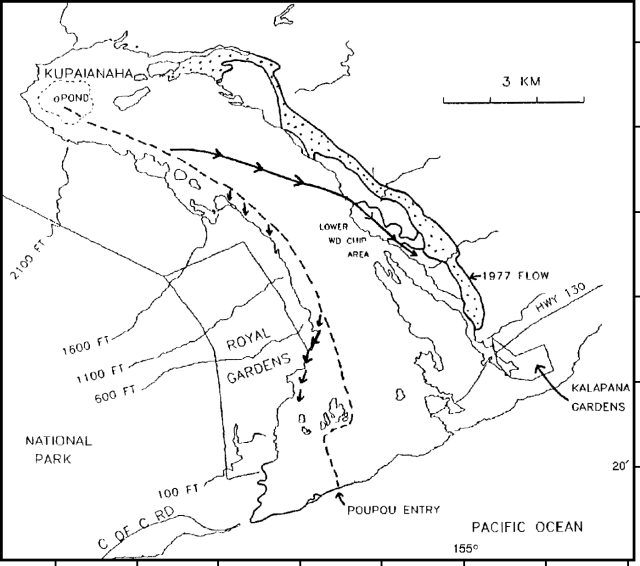 |
Figure 66. Lava flows produced by Kīlauea's Kupaianaha vent, July 1986-March 1990. The dotted line indicates the active lava tube system, dashed lines are flows active before the eruption's 19 March hiatus, and arrows show flow fronts active in late March. Courtesy of C. Heliker. |
Minor surface breakouts at 480-360 m (1,600-1,200 ft) elevation fed small hummocky pahoehoe flows along the W margin of the flow field. A long-lived surface breakout from the main tube at the 180 m (600 ft) elevation (active since late October) sent flows W into Royal Gardens, destroying a house (just below Orchid St.). Surface flows on the coastal plain were limited to the area immediately inland of the Poupou entry . . . , where moderate littoral explosions hurled spatter 10-15 m into the air and built a 2-3-m littoral cone.
Eruption tremor continued at low levels . . . near Pu`u `O`o and Kupaianaha. Tremor of relatively steady amplitude was punctuated by intermittent high-frequency bursts of seismic energy related to crustal adjustments near both the Kalalua (KLC, ~1 km from Kupaianaha) and Steam Cracks (STC, a few kilometers from Pu'u 0'o) seismometers. The most significant of these were two strong 15-minute avalanches registered on the STC instrument at 0240 on 18 January and at 1305 on 21 January. Shallow microearthquake activity in the East rift zone and at the summit was average throughout the month. The daily number of intermediate-depth (5-15 km) long-period events was erratic, with > 100/day occurring 12-14 and 16-18 January. A gradual increase from levels of tens/day to approaching 100/day began 27 January.
Addendum: The first hiatus . . . since April 1988 occurred 7-9 February [but see 15:2]. Kupaianaha's magma supply decreased on the 6th and the flow that had formed 13 January stagnated. By the next day, tremor had generally declined, all flows had stopped, and only small pahoehoe lobes were active around margins of crusted lava in Kupaianaha. Activity resumed late on the 9th, with strong night glow from Pu`u `O`o and a slight increase in tremor. By the next day, lava had returned to Pu`u `O`o and Kupaianaha, and had reoccupied the tube system, with several surface breakouts forming vigorous pahoehoe flows.
Geological Summary. Kilauea overlaps the E flank of the massive Mauna Loa shield volcano in the island of Hawaii. Eruptions are prominent in Polynesian legends; written documentation since 1820 records frequent summit and flank lava flow eruptions interspersed with periods of long-term lava lake activity at Halemaumau crater in the summit caldera until 1924. The 3 x 5 km caldera was formed in several stages about 1,500 years ago and during the 18th century; eruptions have also originated from the lengthy East and Southwest rift zones, which extend to the ocean in both directions. About 90% of the surface of the basaltic shield volcano is formed of lava flows less than about 1,100 years old; 70% of the surface is younger than 600 years. The long-term eruption from the East rift zone between 1983 and 2018 produced lava flows covering more than 100 km2, destroyed hundreds of houses, and added new coastline.
Information Contacts: C. Heliker and P. Okubo, HVO.