Report on Gamalama (Indonesia) — July 1990
Bulletin of the Global Volcanism Network, vol. 15, no. 7 (July 1990)
Managing Editor: Lindsay McClelland.
Gamalama (Indonesia) Strong April explosion ejected incandescent tephra
Please cite this report as:
Global Volcanism Program, 1990. Report on Gamalama (Indonesia) (McClelland, L., ed.). Bulletin of the Global Volcanism Network, 15:7. Smithsonian Institution. https://doi.org/10.5479/si.GVP.BGVN199007-268060
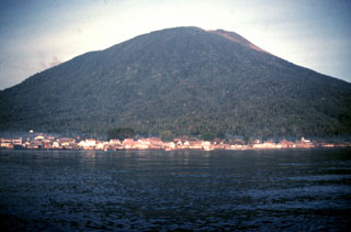
Gamalama
Indonesia
0.81°N, 127.3322°E; summit elev. 1714 m
All times are local (unless otherwise noted)
On 25 April a large explosion at 1848 ejected incandescent tephra from the main crater. The ash column reached 2,500-5,000 m above the volcano and deposited material to the W. The main eruptive activity ceased at 1928, but was followed by smaller eruptions producing ash columns to 1,500 m. A flow, suspected to be a nuée ardente, traveled 4.5 km from the crater, leaving a deposit 5 m thick with a maximum temperature of 320°C. No victims and only minor damage were reported. Activity declined to weak emissions of white to grayish-white vapor 300-500 m above the crater by 30 April.
Geological Summary. Gamalama is a near-conical stratovolcano that comprises the entire island of Ternate off the western coast of Halmahera, and is one of Indonesia's most active volcanoes. The island was a major regional center in the Portuguese and Dutch spice trade for several centuries, which contributed to the extensive documentation of activity. Three cones, progressively younger to the north, form the summit. Several maars and vents define a rift zone, parallel to the Halmahera island arc, that cuts the volcano; the S-flank Ngade maar formed after about 14,500–13,000 cal. BP (Faral et al., 2022). Eruptions, recorded frequently since the 16th century, typically originated from the summit craters, although flank eruptions have occurred in 1763, 1770, 1775, and 1962-63.
Information Contacts: VSI.