Report on Long Island (Papua New Guinea) — September 1990
Bulletin of the Global Volcanism Network, vol. 15, no. 9 (September 1990)
Managing Editor: Lindsay McClelland.
Long Island (Papua New Guinea) Low-level activity at thermal areas
Please cite this report as:
Global Volcanism Program, 1990. Report on Long Island (Papua New Guinea) (McClelland, L., ed.). Bulletin of the Global Volcanism Network, 15:9. Smithsonian Institution. https://doi.org/10.5479/si.GVP.BGVN199009-251050
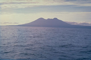
Long Island
Papua New Guinea
5.358°S, 147.12°E; summit elev. 1280 m
All times are local (unless otherwise noted)
"An aerial inspection on 3 September indicated that thermal areas on Motmot . . . remained at a low level of activity. Vegetation was spreading in some areas, notably in the crater of the 1974 cone, and no fresh sulphur deposits were seen.
Geological Summary. The broad profile of hexagonal-shaped Long Island is dominated by two steep-sided stratovolcanoes, Mount Reaumur in the north and Cerisy Peak in the south. Collapse of the basaltic-andesitic volcanic complex produced a large 10 x 12.5 km caldera, now filled by Lake Wisdom. Caldera formation occurred during at least three major explosive eruptions, about 16,000, 4000, and 300 years ago. The latter was one of the largest historical eruptions in Papua New Guinea and deposited andesitic tephra across the New Guinea highlands, prompting legends of a "Time of Darkness." Post-caldera eruptions have constructed a small cone, Motmot Island, in the south-central part of Lake Wisdom. Moderate explosive eruptions have occurred during the 20th century from vents at and near Motmot Island.
Information Contacts: I. Itikarai and C. McKee, RVO.