Report on Kilauea (United States) — October 1990

Bulletin of the Global Volcanism Network, vol. 15, no. 10 (October 1990)
Managing Editor: Lindsay McClelland.
Kilauea (United States) Lava continues to flow into sea; more homes destroyed
Please cite this report as:
Global Volcanism Program, 1990. Report on Kilauea (United States) (McClelland, L., ed.). Bulletin of the Global Volcanism Network, 15:10. Smithsonian Institution. https://doi.org/10.5479/si.GVP.BGVN199010-332010
Kilauea
United States
19.421°N, 155.287°W; summit elev. 1222 m
All times are local (unless otherwise noted)
Lava . . . moved down the S flank and continued to enter the ocean during October (figure 73). At the beginning of the month, lava from a persistent tube system along the E side of the flow field formed a coastal front 750 m wide (in the Kaimu area; figure 72). The E margin of the flow advanced along the coast in front of the Kalapana Shores subdivision, which had been evacuated by the beginning of October. Lava breakouts destroyed two homes in the subdivision on 7 October. By mid-October, lava had nearly reached the W edge of the 1750 flow, > 500 m E of the former Kaimu Bay, and ocean entries were active along a front 1 km wide. A lava breakout from the flow's main ("Woodchip") tube at ~40 m elevation destroyed a home in the upper Kalapana Gardens subdivision on 15 October. A low to moderate number of intermediate-depth long-period earthquakes were evident from the beginning of the month. These peaked 6-7 October when almost 100 were counted, then subsided about 10 October.
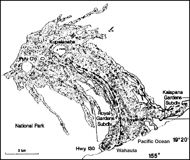 |
Figure 73. Lava produced by Kīlauea's East rift zone eruption, 1983-90. Arrows indicate paths of recent flows, with the "Woodchip" flow on the E side of the lava field, the "Royal Gardens" flow on the W side. Crosses at the coast mark new lava entries into the sea in the Wahaula area. |
Flows that emerged from the inflated area at the base of Kupaianaha's shield in early October moved down the W side of the flow field, the most active as channelized aa that reached relatively level terrain near the coast on 12 October. By the 15th, the distal end of the flow was pahoehoe and had advanced to below 30 m elevation. Less-active lobes of the same flow were observed upslope in Royal Gardens subdivision, but did not destroy any of the subdivision's remaining homes. Lava reached the ocean on 20 October along the W side of the flow field (near Kupapau Point) and was moving through newly formed tubes by the 22nd. A large lava breakout on the E side of the flow field destroyed another home in Kalapana Gardens on 19 October, while activity declined at the coast to only two small entries.
On 22 October a flurry of long-period events occurred between 0500 and 0800, averaging ~30/hour. Long-period seismicity increased again at about 2100, accompanied by summit tremor. The number of intermediate-depth long-period earthquakes, which had resumed in mid-October, peaked at about 380 on the 23rd. That day, lava movement viewed through a skylight at ~350 m elevation was slower than it had been in the past several weeks, and a decline in activity at all coastal entries was evident by 24 October. However, a new lobe from the E side of the flow field reached the ocean on the 24th (at Hakuma Point), an entry that remained intermittently active through early November, and lava that had moved through Royal Gardens in mid-October entered the sea 29 October on the W side of the flow field (just E of Wahaula). By 31 October, lava was flowing into the ocean at several points in the Wahaula area along a front 700 m wide, and the flow feeding this entry was moving through tubes upslope. . . . Intermediate-depth long-period seismicity declined from its peak on 23 October to a few tens of events/day at the end of the month, and dropped further in early November.
A lava pond was seen on 31 October in the base of Pu`u `O`o Crater, where a pair of lava ponds had been active in August and September. Lava at Kupaianaha remained deep in the vent and covered by a frozen crust.
Geological Summary. Kilauea overlaps the E flank of the massive Mauna Loa shield volcano in the island of Hawaii. Eruptions are prominent in Polynesian legends; written documentation since 1820 records frequent summit and flank lava flow eruptions interspersed with periods of long-term lava lake activity at Halemaumau crater in the summit caldera until 1924. The 3 x 5 km caldera was formed in several stages about 1,500 years ago and during the 18th century; eruptions have also originated from the lengthy East and Southwest rift zones, which extend to the ocean in both directions. About 90% of the surface of the basaltic shield volcano is formed of lava flows less than about 1,100 years old; 70% of the surface is younger than 600 years. The long-term eruption from the East rift zone between 1983 and 2018 produced lava flows covering more than 100 km2, destroyed hundreds of houses, and added new coastline.
Information Contacts: T. Moulds and P. Okubo, HVO.