Report on Ol Doinyo Lengai (Tanzania) — January 1991

Bulletin of the Global Volcanism Network, vol. 16, no. 1 (January 1991)
Managing Editor: Lindsay McClelland.
Ol Doinyo Lengai (Tanzania) New lava flows on crater floor
Please cite this report as:
Global Volcanism Program, 1991. Report on Ol Doinyo Lengai (Tanzania) (McClelland, L., ed.). Bulletin of the Global Volcanism Network, 16:1. Smithsonian Institution. https://doi.org/10.5479/si.GVP.BGVN199101-222120
Ol Doinyo Lengai
Tanzania
2.764°S, 35.914°E; summit elev. 2962 m
All times are local (unless otherwise noted)
The following . . . is based on photographs taken during overflights on 2 November (S. Cunningham) and 1 December (F. Barnes). No major changes were apparent since fieldwork 7-8 August and an overflight on 7 September.
Two new lava flows were observed during the 2 November overflight (figure 20). The first known lava from cone T11 since November 1988 (F21) had reached the S and E walls of the crater's southern depression, and covered >50% of the depression's floor (S of the former saddle M1M2). Its source cone remained horseshoe-shaped and open to the S, with a central hole surrounded by very dark, fresh lava. A narrow fissure extended from the SW side of the horseshoe into a large zone of very dark gray lava that was probably at most a few hours old. The second new flow (F22), ~1/3 the volume of F21, probably emerged from a low dome (T15) at the N foot of the crater floor's largest cone (T5/T9), where little or no growth has occurred since September. The lava advanced W, dividing into two lobes, one of which skirted the S and W edges of a complex of three cones (T4/T7), each with a small summit vent, that appeared little changed since September. Its largest (E) cone (T14) had been active in August, and dark, fresh-looking material that appeared to be lava and spatter was visible on its NE side. Lineations on the SW part of the crater floor, similar to those seen in June 1988, may have been discoloration from fumarolic activity. A large slab had split away from the E wall (at U1) and considerable new talus was seen on top of old lava at the wall's base.
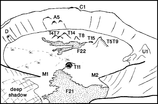 |
Figure 20. Ol Doinyo Lengai, looking N on 2 November 1990. Dashed lines labeled "xxx" are inferred zones of fumarolic activity. Sketches by C. Nyamweru from photographs by S. Cunningham. |
The 1 December overflight revealed an additional new lava flow (F23) extending E (from T5/T9) to the E base of the crater wall. This flow was not present in the 2 November photographs, but its pale gray color suggested that it [was] extruded shortly thereafter. No dark areas, characteristic of active or very recent lava, were visible on the crater floor. A small circular vent-like feature had formed on the W end of T4/T7 ridge, but had not produced new lava. Lines of fumaroles were clearly visible on the crater floor.
Geological Summary. The symmetrical Ol Doinyo Lengai is the only volcano known to have erupted carbonatite tephras and lavas in historical time. The prominent stratovolcano, known to the Maasai as "The Mountain of God," rises abruptly above the broad plain south of Lake Natron in the Gregory Rift Valley. The cone-building stage ended about 15,000 years ago and was followed by periodic ejection of natrocarbonatitic and nephelinite tephra during the Holocene. Historical eruptions have consisted of smaller tephra ejections and emission of numerous natrocarbonatitic lava flows on the floor of the summit crater and occasionally down the upper flanks. The depth and morphology of the northern crater have changed dramatically during the course of historical eruptions, ranging from steep crater walls about 200 m deep in the mid-20th century to shallow platforms mostly filling the crater. Long-term lava effusion in the summit crater beginning in 1983 had by the turn of the century mostly filled the northern crater; by late 1998 lava had begun overflowing the crater rim.
Information Contacts: C. Nyamweru, Kenyatta Univ.