Report on Ol Doinyo Lengai (Tanzania) — March 1991

Bulletin of the Global Volcanism Network, vol. 16, no. 3 (March 1991)
Managing Editor: Lindsay McClelland.
Ol Doinyo Lengai (Tanzania) Continued lava emission
Please cite this report as:
Global Volcanism Program, 1991. Report on Ol Doinyo Lengai (Tanzania) (McClelland, L., ed.). Bulletin of the Global Volcanism Network, 16:3. Smithsonian Institution. https://doi.org/10.5479/si.GVP.BGVN199103-222120
Ol Doinyo Lengai
Tanzania
2.764°S, 35.914°E; summit elev. 2962 m
All times are local (unless otherwise noted)
The following . . . is based on photographs taken during an overflight on 8 January (G. Price). No major changes were apparent since . . . 1 December. The largest cone (T5/T9) continued to be the main source of new lava (figure 21), which has tended to break out at the base of the cone in small mounds. One of these, T15, was the source vent of lava flows first observed 2 November (F22) and 8 January (F24). Several new mounds were visible (T15A, T8A, and T17), and flow F23 (first seen 1 December) was medium brown, indicating fairly fresh material. Some black spatter was visible at the top of T14. The cone complex at T4/T7 ridge had collapsed (and the ridge was renamed T16). The area of slumping on the E wall (U1), noted on 2 November, had changed little, although some fresh talus was apparent.
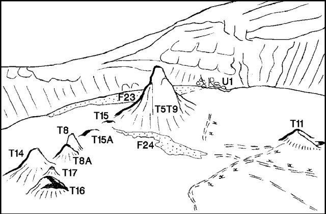 |
Figure 21. Ol Doinyo Lengai, looking SE across the active crater, 8 January 1991. Dashed lines labeled "xxx" are fissures along which some fumarolic activity has apparently occurred. Sketches by C. Nyamweru, from photo by G. Price. |
Geological Summary. The symmetrical Ol Doinyo Lengai is the only volcano known to have erupted carbonatite tephras and lavas in historical time. The prominent stratovolcano, known to the Maasai as "The Mountain of God," rises abruptly above the broad plain south of Lake Natron in the Gregory Rift Valley. The cone-building stage ended about 15,000 years ago and was followed by periodic ejection of natrocarbonatitic and nephelinite tephra during the Holocene. Historical eruptions have consisted of smaller tephra ejections and emission of numerous natrocarbonatitic lava flows on the floor of the summit crater and occasionally down the upper flanks. The depth and morphology of the northern crater have changed dramatically during the course of historical eruptions, ranging from steep crater walls about 200 m deep in the mid-20th century to shallow platforms mostly filling the crater. Long-term lava effusion in the summit crater beginning in 1983 had by the turn of the century mostly filled the northern crater; by late 1998 lava had begun overflowing the crater rim.
Information Contacts: C. Nyamweru, Kenyatta Univ.