Report on Ruapehu (New Zealand) — March 1991

Bulletin of the Global Volcanism Network, vol. 16, no. 3 (March 1991)
Managing Editor: Lindsay McClelland.
Ruapehu (New Zealand) Lake temperatures decrease, then stabilize
Please cite this report as:
Global Volcanism Program, 1991. Report on Ruapehu (New Zealand) (McClelland, L., ed.). Bulletin of the Global Volcanism Network, 16:3. Smithsonian Institution. https://doi.org/10.5479/si.GVP.BGVN199103-241100
Ruapehu
New Zealand
39.28°S, 175.57°E; summit elev. 2797 m
All times are local (unless otherwise noted)
Crater Lake temperature continued to decrease ... to 24°C at the end of December, then fluctuated between 24 and 27°C through 21 March (figure 12). Several dips to 20°C were believed related to heavy rainfall. Upwelling and occasional yellow sulfur slicks were observed above the N vents, although no activity was detected above the central vents. The Mg/Cl ratio decreased from 0.053 on 9 October to 0.046 on 27 December, then ranged between 0.45 and 0.50 during 18 January-21 March.
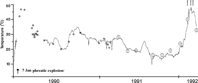 |
Figure 12. Crater Lake temperatures at Ruapehu, January 1990-24 March 1992, from a continuously-recording instrument (curve) and individual measurements by geologists (circled crosses). An arrow marks the January 1990 phreatic explosions. |
Seismicity has remained low since August. Low levels of 2-Hz tremor were recorded until early February, when low to moderate levels of 3-Hz tremor began. Until early 1988, 3-Hz tremor usually occurred during periods of high lake temperatures, but this pattern is no longer evident. Deformation measurements showed that the crater width was stable from 9 October with minor shortening measured 8 February-21 March.
Geological Summary. Ruapehu, one of New Zealand's most active volcanoes, is a complex stratovolcano constructed during at least four cone-building episodes dating back to about 200,000 years ago. The dominantly andesitic 110 km3 volcanic massif is elongated in a NNE-SSW direction and surrounded by another 100 km3 ring plain of volcaniclastic debris, including the NW-flank Murimoto debris-avalanche deposit. A series of subplinian eruptions took place between about 22,600 and 10,000 years ago, but pyroclastic flows have been infrequent. The broad summait area and flank contain at least six vents active during the Holocene. Frequent mild-to-moderate explosive eruptions have been recorded from the Te Wai a-Moe (Crater Lake) vent, and tephra characteristics suggest that the crater lake may have formed as recently as 3,000 years ago. Lahars resulting from phreatic eruptions at the summit crater lake are a hazard to a ski area on the upper flanks and lower river valleys.
Information Contacts: B. Scott, DSIR Rotorua.