Report on Pinatubo (Philippines) — March 1991

Bulletin of the Global Volcanism Network, vol. 16, no. 3 (March 1991)
Managing Editor: Lindsay McClelland.
Pinatubo (Philippines) 2,000 evacuated after explosion emits ash; new vents; increased seismicity and sulfurous odor
Please cite this report as:
Global Volcanism Program, 1991. Report on Pinatubo (Philippines) (McClelland, L., ed.). Bulletin of the Global Volcanism Network, 16:3. Smithsonian Institution. https://doi.org/10.5479/si.GVP.BGVN199103-273083
Pinatubo
Philippines
15.13°N, 120.35°E; summit elev. 1486 m
All times are local (unless otherwise noted)
The press reported that an explosion on 2 April deposited ash over an area of about 10,000 m2, including part of one village, and that about 2,000 people were evacuated. No injuries or deaths were reported. PHIVOLCS confirmed the explosion, and later noted a SW-NE-trending line of new vents extending 0.5-1.0 km on the N side of the volcano. The vents continued to emit a gas plume 200-500 m high as of mid-April. Observers at Clark Air Force Base (~15 km E) reported sulfurous odors. A seismic net, installed following the 2 April explosion, recorded increasing seismicity, reaching 135 earthquakes on 15 April.
Pinatubo ([pre-eruption] summit elevation 1,745 m), 100 km NW of Manila (figure 1), is composed of a high-silica hornblende andesite-dacite dome complex, possibly located within a small caldera. The most recent eruption (635 ± 90 years ago: 14C) produced pumiceous pyroclastic flows that filled the Marella River valley, leading SW from the summit [and part of the E flank's Sacobia River valley]. Similar deposits of pyroclastic flows and mudflows from older eruptions fill other canyons around the volcano. Geothermal wells (drilled by the Philippine National Oil Company) just N of the summit a few years ago encountered highly acidic, Cl-rich fluid, with a temperature of 340°C at 2.5 km depth.
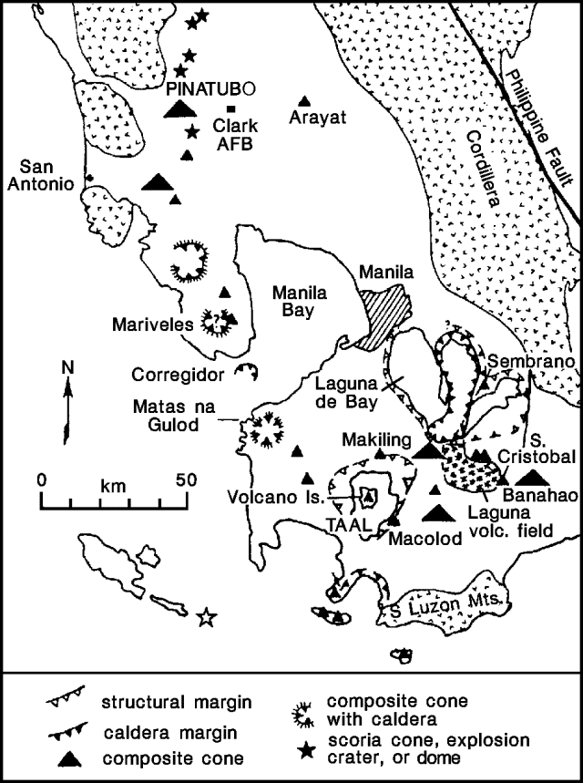 |
Figure 1. Map showing the location of Pinatubo, Taal, and other Neogene volcanoes of SW Luzon Island, Philippines. After Wolfe and Self, 1983. |
Reference. Wolfe, J.A., and Self, S., 1983, Structural lineaments and Neogene volcanism in southwestern Luzon, in Hayes, D.E., ed., The tectonic and geologic evolution of Southeast Asian seas and islands, part 2: American Geophysical Union Monograph 27, p. 157-172.
Geological Summary. Prior to 1991 Pinatubo volcano was a relatively unknown, heavily forested lava dome complex located 100 km NW of Manila with no records of historical eruptions. The 1991 eruption, one of the world's largest of the 20th century, ejected massive amounts of tephra and produced voluminous pyroclastic flows, forming a small, 2.5-km-wide summit caldera whose floor is now covered by a lake. Caldera formation lowered the height of the summit by more than 300 m. Although the eruption caused hundreds of fatalities and major damage with severe social and economic impact, successful monitoring efforts greatly reduced the number of fatalities. Widespread lahars that redistributed products of the 1991 eruption have continued to cause severe disruption. Previous major eruptive periods, interrupted by lengthy quiescent periods, have produced pyroclastic flows and lahars that were even more extensive than in 1991.
Information Contacts: R. Punongbayan, PHIVOLCS; Chris Newhall, USGS; Marc Defant and Juan Delfin, Univ of South Florida; AP; Reuters.