Report on Whakaari/White Island (New Zealand) — February 1992

Bulletin of the Global Volcanism Network, vol. 17, no. 2 (February 1992)
Managing Editor: Lindsay McClelland.
Whakaari/White Island (New Zealand) Vigorous explosions; vent conduit collapse
Please cite this report as:
Global Volcanism Program, 1992. Report on Whakaari/White Island (New Zealand) (McClelland, L., ed.). Bulletin of the Global Volcanism Network, 17:2. Smithsonian Institution. https://doi.org/10.5479/si.GVP.BGVN199202-241040
Whakaari/White Island
New Zealand
37.52°S, 177.18°E; summit elev. 294 m
All times are local (unless otherwise noted)
Explosive activity continued through January. A large ash emission event on 17 January deposited ash 50 km S, and was associated with a large high-frequency seismic episode. The 17 January event marked a change from Strombolian ejections of scoriaceous bombs and juvenile ash, to emissions of ash-sized tephra dominated by lithics and altered glass.
Tephra ejection, December to mid-January. R. Fleming (Waimana Helicopters pilot) reported that Wade crater (formed in mid-October 1991) remained very active in late December and early January, emitting scoriae and bombs (to 30 m height) that were scattered over most of the W end of the main crater floor. The largest bombs were ejected after heavy rainfall at the beginning of January, but volcano noise (booming at 1-2-second intervals) heard during earlier visits had diminished after the rainfall. TV1 Crater (formed in October 1990) occasionally emitted ash, but no emissions were observed from May 91 vent.
B.J. Hogg and P. Horn reported observing an eruption from a boat 8 km E of the island shortly after 2000 on 16 January, coinciding with a recorded E-type earthquake. The initial gray-brown plume, ~150-180 m high, was followed by a separate brown ash column that rose ~900-1,500 m. Ashfall quickly obscured the W and S portions of the island. Roughly 15 minutes into the eruption, ash was observed cascading down the outer margins of the eruption column. Vigorous ash emission continued for at least an hour.
Strong explosion, 17 January. At 0932 on 17 January, seismometers registered the largest discrete seismic event ever recorded at the volcano (figure 16). Boats contacted at 1000-1015 reported limited visibility due to deteriorating weather, but that a "change to heavy ashfall had occurred within the last half hour." The New Zealand Herald reported that a yacht sailing close to the S coast of White Island at about 1100 had its sails coated with mud, and was later dismasted. Ashfall was reported 50 km S (in the Whakatane area) between 1115 and 1130. Geologists suggested that the 17 January explosion was probably caused by subterranean collapse of Wade Crater's conduit wall onto the top of the magma column at considerable depth. This resulted in a change from "open-vent" Strombolian eruptions of scoriaceous bombs, to "closed vent" phreatomagmatic eruptions of altered, lithic-dominated, mostly ash-sized ejecta.
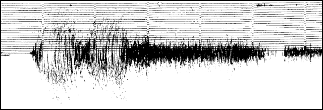 |
Figure 16. Seismogram showing a large high-frequency event at White Island, 0932 on 17 January 1992. Ticks are at 1-minute intervals. Courtesy of DSIR. |
Post-17 January fieldwork. Only a thin layer of light gray ash covered the island during fieldwork on 22 January, suggesting that most of the ash erupted on 17 January had been carried offshore by strong winds. About 32 cm of tephra had been deposited on the 1978/90 Crater rim (S of TV1) since 5 December, of which 11 cm were believed to be associated with 17-22 January activity. No surge deposits were recognized. The largest of the ash-covered blocks and bombs (up to 1.3 m long), found ~200 m E of Wade Crater, had been deposited before 17 January.
No significant changes had occurred to visible parts of the three recently active vents since fieldwork on 5 and 6 December. Wade Crater emitted a vigorously convoluting column of very fine dark gray-brown ash and white gas. White blocks (perhaps baked lithic material) were occasionally ejected. Most of the ash fell back into the vent. Noise from the crater was subdued, in comparison with 5 December, and the dull "booms" had no obvious correlation with emissions. TV1 Crater quietly emitted a small continuous plume of light gray ash that fell to ~100 m ENE, onto an area covered by a layer of recent ash and blocks.
During fieldwork on 23 January, Wade Crater erupted fine red ash, which became more predominant through the day. A distinctive gray-white ash deposit was apparent around the NE margin of 1978/90 Crater Complex, above TV1 Crater. Deposits of fine yellow-green ash, not apparent in photos taken on 22 January, mantled the ground elsewhere on Main Crater floor and on the outer SW slopes. Ash emissions from Wade Crater were stronger on 24 January and conspicuously redder. When geologists left the area at 1635, ash was falling at sea, downwind of the island.
On 31 January, a steam column with small quantities of pink ash from Wade Crater and a light gray column from TV1 combined to form a weakly convoluting pink-brown plume 400 m high. Solar panels 600 m SE of Wade had accumulated ~20 mm of ash since 22 January.
Seismicity. Before 9 December, episodic medium-frequency volcanic tremor accompanied open-vent Strombolian activity at variable, but low amplitude. Tremor declined after 12 December, and was replaced by more discrete, medium-frequency (C-type) events (~200/day) that lasted until 22 December. Relatively brief E-type (eruption) events were recorded on 11, 13, 16, and 17 December (at 1802, 1003, 1921, and 0723, respectively), and rare B-type events were recorded after 16 December. No signal was received 23-27 December.
B-type shocks and microearthquakes dominated the seismic records by 1 January, with 5-10/minute occurring in bursts lasting 3.5-8 hours. Microearthquake activity declined about 6 January, while the number of B-type earthquakes increased, peaking at >20/day on 11 January. A-type earthquakes remained constant, around 3-4/day. E-type sequences reappeared on 7 January, and occurred daily until 17 January, as B-type earthquakes decreased in number. A distinctly different, high-frequency, long-duration event (figure 16) occurred at 0932 on 17 January, shortly before reports of heavy ashfall. A sequence of 18 A-type earthquakes followed in the next 10 hours, and medium- to low-frequency volcanic tremor of variable but increasing amplitude commenced. After 18 January, 5-6 B-type and fewer A-type earthquakes were recorded daily. E-type events were recorded on 21 and 25 January (at 0312 and 1438, respectively), the latter accompanying a voluminous ash eruption. Increasing ash emission interrupted the seismic telemetry link on 26 January.
Geological Summary. The uninhabited Whakaari/White Island is the 2 x 2.4 km emergent summit of a 16 x 18 km submarine volcano in the Bay of Plenty about 50 km offshore of North Island. The island consists of two overlapping andesitic-to-dacitic stratovolcanoes. The SE side of the crater is open at sea level, with the recent activity centered about 1 km from the shore close to the rear crater wall. Volckner Rocks, sea stacks that are remnants of a lava dome, lie 5 km NW. Descriptions of volcanism since 1826 have included intermittent moderate phreatic, phreatomagmatic, and Strombolian eruptions; activity there also forms a prominent part of Maori legends. The formation of many new vents during the 19th and 20th centuries caused rapid changes in crater floor topography. Collapse of the crater wall in 1914 produced a debris avalanche that buried buildings and workers at a sulfur-mining project. Explosive activity in December 2019 took place while tourists were present, resulting in many fatalities. The official government name Whakaari/White Island is a combination of the full Maori name of Te Puia o Whakaari ("The Dramatic Volcano") and White Island (referencing the constant steam plume) given by Captain James Cook in 1769.
Information Contacts: I. Nairn and B. Scott, DSIR Rotorua.