Report on Merapi (Indonesia) — March 1992

Bulletin of the Global Volcanism Network, vol. 17, no. 3 (March 1992)
Managing Editor: Lindsay McClelland.
Merapi (Indonesia) Continued lava extrusion; small rockfalls and avalanche-generated pyroclastic flows
Please cite this report as:
Global Volcanism Program, 1992. Report on Merapi (Indonesia) (McClelland, L., ed.). Bulletin of the Global Volcanism Network, 17:3. Smithsonian Institution. https://doi.org/10.5479/si.GVP.BGVN199203-263250
Merapi
Indonesia
7.54°S, 110.446°E; summit elev. 2910 m
All times are local (unless otherwise noted)
Glowing rockfalls continued from Merapi's 1992 dome. They were channeled into the headwaters of rivers on the NW (Senowo), W (Putih), and SW (Bebeng) flanks, extending 300-2,000 m from the dome. The number of rockfalls and multiphase earthquakes generally decreased after late February, although they still dominated seismic records (figure 5). Occasional avalanche-generated pyroclastic flows remained relatively small and traveled a maximum of 2,000 m downslope. The plume was low (to 550 m height), relatively thin, and white. The average SO2 flux measured by COSPEC (figure 6) was 324 t/d through mid-April, with individual measurements ranging from 32 to 419 t/d, the highest on 2 April. As of mid-April, Merapi remained at a Level-1 Alert (see 17:2 for details of the alert system), with summit climbs by the public prohibited.
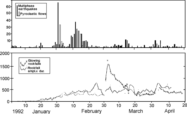 |
Figure 5. Merapi's daily number of glowing rockfalls, multiphase earthquakes, and pyroclastic flow events, with amplitudes x durations of glowing rockfalls, January-April 1992. Courtesy of MVO. |
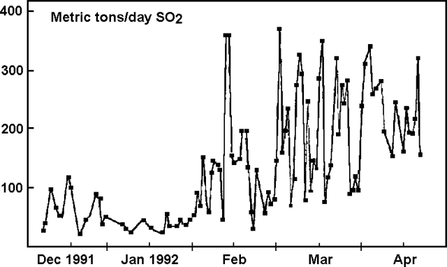 |
Figure 6. Daily average SO2 flux measured by COSPEC at Merapi, December 1991-early April 1992. Courtesy of MVO. |
[1988 and 1990-91 seismicity and deformation data were moved to follow 15:7]
Geological Summary. Merapi, one of Indonesia's most active volcanoes, lies in one of the world's most densely populated areas and dominates the landscape immediately north of the major city of Yogyakarta. It is the youngest and southernmost of a volcanic chain extending NNW to Ungaran volcano. Growth of Old Merapi during the Pleistocene ended with major edifice collapse perhaps about 2,000 years ago, leaving a large arcuate scarp cutting the eroded older Batulawang volcano. Subsequent growth of the steep-sided Young Merapi edifice, its upper part unvegetated due to frequent activity, began SW of the earlier collapse scarp. Pyroclastic flows and lahars accompanying growth and collapse of the steep-sided active summit lava dome have devastated cultivated lands on the western-to-southern flanks and caused many fatalities.
Information Contacts: B. Voight, Pennsylvania State Univ.