Report on Kavachi (Solomon Islands) — September 1992
Bulletin of the Global Volcanism Network, vol. 17, no. 9 (September 1992)
Managing Editor: Lindsay McClelland.
Kavachi (Solomon Islands) Bathymetric survey reveals gas emission
Please cite this report as:
Global Volcanism Program, 1992. Report on Kavachi (Solomon Islands) (McClelland, L., ed.). Bulletin of the Global Volcanism Network, 17:9. Smithsonian Institution. https://doi.org/10.5479/si.GVP.BGVN199209-255060
Kavachi
Solomon Islands
8.991°S, 157.979°E; summit elev. -20 m
All times are local (unless otherwise noted)
A bathymetric survey in the vicinity of Kavachi volcano was carried out on 11 August by the HMNZS Tui. The ship made three parallel transits, ~1,200 m apart, over the summit of the unnamed seamount ~7 km NW of Kavachi. The summit is mostly flat, with a depth of at least 130 m found on each pass. The transit farthest NE showed a shallow and a deep crater on the tracing of the 12 kHz echo sounder. The 44-kHz echo sounder showed two small plumes rising to mid-water depth on either side of the smaller crater.
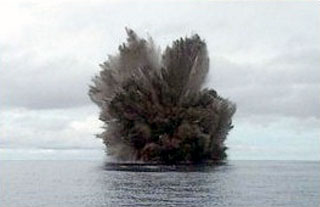
Near Kavachi itself, inflatable boats with hand-held echo sounders and portable GPS receivers were used to determine spot water-depths. A sulfur smell and a patch of milk-colored water 20 m in diameter were reported by boat crews near the shallowest (20 m) depth location (8.994°S, 157.973°E). Several other similar patches were observed within 150 m of this point, in water 20-30 m deep.
Geological Summary. Named for a sea-god of the Gatokae and Vangunu peoples, Kavachi is located in the Solomon Islands south of Vangunu Island. Sometimes referred to as Rejo te Kvachi ("Kavachi's Oven"), this shallow submarine basaltic-to-andesitic volcano has produced ephemeral islands up to 1 km long many times since its first recorded eruption during 1939. Residents of the nearby islands of Vanguna and Nggatokae (Gatokae) reported "fire on the water" prior to 1939, a possible reference to earlier eruptions. The roughly conical edifice rises from water depths of 1.1-1.2 km on the north and greater depths to the SE. Frequent shallow submarine and occasional subaerial eruptions produce phreatomagmatic explosions that eject steam, ash, and incandescent bombs. On a number of occasions lava flows were observed on the ephemeral islands.
Information Contacts: L. Hall, Defence Scientific Establishment, and Lt. Cdr. G. Craig, HMNZSTui, Auckland Naval Base, New Zealand.