Report on Submarine Volcano NNE of Iriomotejima (Japan) — December 1992
Submarine Volcano NNE of Iriomotejima
Bulletin of the Global Volcanism Network, vol. 17, no. 12 (December 1992)
Managing Editor: Lindsay McClelland.
Submarine Volcano NNE of Iriomotejima (Japan) Strong submarine earthquake swarms but no surface changes
Please cite this report as:
Global Volcanism Program, 1992. Report on Submarine Volcano NNE of Iriomotejima (Japan) (McClelland, L., ed.). Bulletin of the Global Volcanism Network, 17:12. Smithsonian Institution. https://doi.org/10.5479/si.GVP.BGVN199212-282010
Submarine Volcano NNE of Iriomotejima
Japan
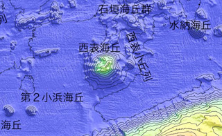
24.57°N, 123.93°E; summit elev. -200 m
All times are local (unless otherwise noted)
An earthquake swarm occurred at the W tip of the island 24-31 August, including a M 5.2 shock at 9 km depth on 24 August (figure 3). A total of 24 earthquakes was detected at Iriomote-jima Weather Station, on the NW coast of the island.
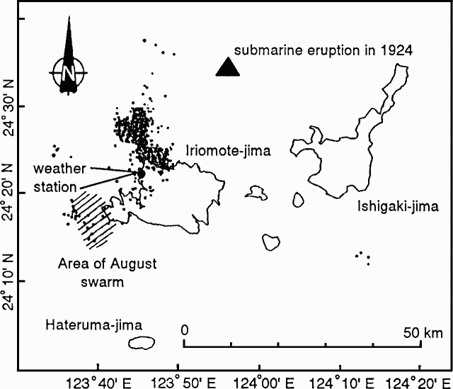 |
Figure 3. Epicenters of earthquakes near Iriomote-jima (filled circles), September-November, 1992. Diagonal lines mark the area of the August 1992 swarm. Courtesy of JMA. |
A second, more severe swarm began on 17 September, centered a few kilometers N of the island and about 20 km NE of the August swarm. Epicenters migrated towards the island, and by November, the source area encompassed the northern coast. Depths ranged from 0 to 10 km, concentrated at around 5 km.
Seismicity gradually declined toward the end of 1992, after a peak in mid-October when 112 earthquakes were recorded on the 14th (figure 4). The swarm's largest shock was M 5.2 on 20 October. A total of 1316 earthquakes occurred from 17 September to 31 December. A network of ten seismometers recorded no volcanic tremors, and no anomalies were observed on the land or sea surface.
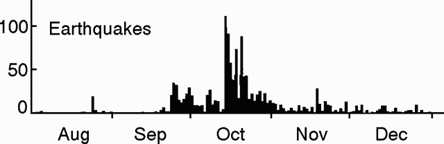 |
Figure 4. Daily number of earthquakes at Iriomote-jima, 1 August-31 December 1992. Courtesy of JMA. |
The most recent seismic activity had occurred in the same area from January-May 1991, when 676 earthquakes were recorded, the largest M 4.3 (16:3-4).
Geological Summary. The southernmost Ryukyu Islands volcano is a shallow submarine volcano 20 km NNE of Iriomotejima island and 35 km WSW of the northern tip of the island of Ishigakishima in an area with an estimated depth of 200-300 m. A major submarine eruption on 31 October 1924 produced rhyolitic pumice rafts with an estimated volume of about 1 km3 that were carried by currents along both coasts of Japan as far north as Hokkaido. The largest pumice blocks exceeded 1 x 2 m in size, and the volume of ejecta places this poorly known eruption among the largest recorded in Japan.
Information Contacts: JMA.