Report on Pinatubo (Philippines) — February 1993

Bulletin of the Global Volcanism Network, vol. 18, no. 2 (February 1993)
Managing Editor: Edward Venzke.
Pinatubo (Philippines) Seismic activity continues
Please cite this report as:
Global Volcanism Program, 1993. Report on Pinatubo (Philippines) (Venzke, E., ed.). Bulletin of the Global Volcanism Network, 18:2. Smithsonian Institution. https://doi.org/10.5479/si.GVP.BGVN199302-273083
Pinatubo
Philippines
15.13°N, 120.35°E; summit elev. 1486 m
All times are local (unless otherwise noted)
Volcanic activity continues at Pinatubo. The following summarizes activity recorded in two 24-hour periods.
For the 24-hour period starting at 0600 on 02 March, a seismometer located 9 km SE of the crater recorded 17 high-frequency volcanic earthquakes. During the same period, a seismometer on the N rim recorded 18 high-frequency and 1 low-frequency volcanic earthquakes. The seismometer on the rim continued to record the small-amplitude low-frequency harmonic tremor that began 23 February. The tremor is similar to the tremor episodes associated with the volcano's dome building activity in July 1992, and indicates vertical movement of magma. During a 24-hour period beginning at 0600 on 19 March, 16 high-frequency and 2 low-frequency events were detected by the seismometer 9 km distant, while 12 high-frequency events and no low-frequency harmonic tremor were recorded. Weak to moderate emissions of white steam reaching heights 200-500 m above the caldera rim were observed from Clark Air Base on the morning of 19 March.
Steve O'Meara observed the caldera during an overflight on 8 March (figure 29). "The SW caldera floor was covered with a kidney-bean-shaped green lake, of which a portion is stained grayish black. The discoloration might have been from recent ash deposits or from runoff entering the lake from the caldera walls (though there does not appear to be any rivulets associated with that particular section of the lake). A striking black river with golden edges cuts through the talus SE of the dome. The N caldera floor was covered with what appeared to be a fresh layer of gray ash covering the talus, which was dappled with explosion pits. A steaming, black dome complex with at least three major lobes rose above the central floor. The dome's active portion had a tall spine. Several steaming cinder cones and remnant explosion pits were visible, and one of the pits contained a green pond. The smell of sulfur gases was intense above the cinder cones."
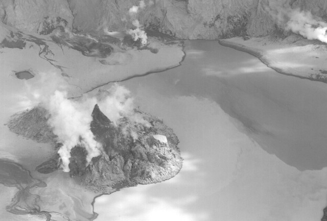 |
Figure 29. Photograph of the crater of Mount Pinatubo looking SE, 8 March 1993. Courtesy of Stephen O'Meara. |
Pinatubo erupted violently in June 1991, killing more than 700 people. The Philippine Institute of Volcanology and Seismology is maintaining Alert Level 3 at Pinatubo, warning that an explosive eruption is possible. Recommendations to avoid the 10-km radius "danger zone" around the volcano remain in effect.
Geological Summary. Prior to 1991 Pinatubo volcano was a relatively unknown, heavily forested lava dome complex located 100 km NW of Manila with no records of historical eruptions. The 1991 eruption, one of the world's largest of the 20th century, ejected massive amounts of tephra and produced voluminous pyroclastic flows, forming a small, 2.5-km-wide summit caldera whose floor is now covered by a lake. Caldera formation lowered the height of the summit by more than 300 m. Although the eruption caused hundreds of fatalities and major damage with severe social and economic impact, successful monitoring efforts greatly reduced the number of fatalities. Widespread lahars that redistributed products of the 1991 eruption have continued to cause severe disruption. Previous major eruptive periods, interrupted by lengthy quiescent periods, have produced pyroclastic flows and lahars that were even more extensive than in 1991.
Information Contacts: PHIVOLCS; Stephen O'Meara, Sky & Telescope, MA.