Report on Ol Doinyo Lengai (Tanzania) — April 1993

Bulletin of the Global Volcanism Network, vol. 18, no. 4 (April 1993)
Managing Editor: Edward Venzke.
Ol Doinyo Lengai (Tanzania) Carbonatite lava production continues
Please cite this report as:
Global Volcanism Program, 1993. Report on Ol Doinyo Lengai (Tanzania) (Venzke, E., ed.). Bulletin of the Global Volcanism Network, 18:4. Smithsonian Institution. https://doi.org/10.5479/si.GVP.BGVN199304-222120
Ol Doinyo Lengai
Tanzania
2.764°S, 35.914°E; summit elev. 2962 m
All times are local (unless otherwise noted)
Carbonatite lava extrusion since February 1992 has centered on [T20] (figure 27). Lava production has continued since September [1992] as new lava flows from T20 have surrounded other cones with up to 4 m of new material.
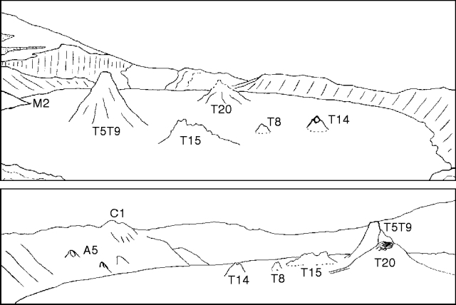 |
Figure 27. Panorama of Ol Doinyo Lengai crater on 23 February 1993 looking SW from the E rim (top) and looking E from the W rim (bottom). Crater diameter is ~330 m. Drawn by C. Nyamweru from photographs taken by H. Martin and P. Robinson. |
Although no activity was observed on 23 February when David Peterson, Paul Robinson, and a group of St. Lawrence Univ students descended to the crater floor for ~3.5 hours in the morning, morphological changes indicated continued lava production from vent T20. Heather Martin reported that no liquid lava was visible in the vents or on the crater floor, but that steam was being emitted from almost all of the vents, especially T5/T9 and T20 (figure 27), and from the base of the W inner crater wall. There was also a strong smell of sulfur near the vents, and intermittent rumbling, thumping, and cracking noises were heard coming from beneath the crater floor and the two vents named above. The crater floor consisted of large, relatively smooth, but heavily cracked, pale grayish-tan plates. Crystalline sulfur deposits (green/yellow/rust/white) were present along cracks. No dark, fresh flows were observed. The E-W diameter of the crater was estimated to be 330 m, and the E wall behind T5/T9 was estimated to be 32 m high. Rim cone C1 and feature A5 were very pale compared to the color of the rest of the N wall.
The upper 5 m of cone T8 was still visible after being partially buried by several younger lava flows, now white in color. The vent on the E side of the summit of T14 remained open, although younger white-to-pale gray lavas have also surrounded this 6.4-m-high cone. Yellow sulfur staining was visible on the upper slopes of both the T8 and T14 cones. Vent T5/T9 (21 m high) remained the tallest feature on the crater floor, though the sharp junction at the base of the cone indicates that it has also been surrounded by younger flows. There have been no noticeable changes since last September to the 8-m-high T15 cone, which still has pale-gray lower slopes and jagged dark upper slopes. Vent T19 and feature D, possibly an older lava flow that has been visible for several years (figure 26), have apparently been completely buried by younger flows.
Based on the depth of lava that has surrounded the older T5/T9, T8, and T14 cones (1.5-4 m), the base of the crater wall, and the remains of the M2 spur, it is clear that a considerable volume of lava has been extruded since . . . 30 September 1992. The source of most or all of this lava appears to be the T20 vent . . . . Vent T20 has blackened upper slopes with an open vent on the W upper slope and a lava tunnel 2-3 m deep and 1-2 m high that extends ~50 m to the SE. The smooth lava that gently slopes up from the crater floor around T20 resulted in height estimates for T20 that varied between 7 and 14 m.
Geological Summary. The symmetrical Ol Doinyo Lengai is the only volcano known to have erupted carbonatite tephras and lavas in historical time. The prominent stratovolcano, known to the Maasai as "The Mountain of God," rises abruptly above the broad plain south of Lake Natron in the Gregory Rift Valley. The cone-building stage ended about 15,000 years ago and was followed by periodic ejection of natrocarbonatitic and nephelinite tephra during the Holocene. Historical eruptions have consisted of smaller tephra ejections and emission of numerous natrocarbonatitic lava flows on the floor of the summit crater and occasionally down the upper flanks. The depth and morphology of the northern crater have changed dramatically during the course of historical eruptions, ranging from steep crater walls about 200 m deep in the mid-20th century to shallow platforms mostly filling the crater. Long-term lava effusion in the summit crater beginning in 1983 had by the turn of the century mostly filled the northern crater; by late 1998 lava had begun overflowing the crater rim.
Information Contacts: C. Nyamweru, St. Lawrence Univ; D. Peterson, Arusha; P. Robinson, Nairobi, Kenya; H. Martin, Norwood, NY; A. Prime, Hingham, MA.