Report on Taal (Philippines) — February 1994

Bulletin of the Global Volcanism Network, vol. 19, no. 2 (February 1994)
Managing Editor: Richard Wunderman.
Taal (Philippines) Rise in seismicity, deformation, and temperature
Please cite this report as:
Global Volcanism Program, 1994. Report on Taal (Philippines) (Wunderman, R., ed.). Bulletin of the Global Volcanism Network, 19:2. Smithsonian Institution. https://doi.org/10.5479/si.GVP.BGVN199402-273070
Taal
Philippines
14.0106°N, 120.9975°E; summit elev. 311 m
All times are local (unless otherwise noted)
Beginning in late February 1994, Taal stratovolcano underwent increases in seismicity, deformation, temperature, and other signs of growing instability. The stratovolcano sits in the center of a 15 x 22 km caldera occupied by Taal lake. Taal stratovolcano, which is sometimes also referred to as either Volcano Island or Taal Island, has a central, 6-km-diameter crater lake termed the main crater lake (figures 5 and 6).
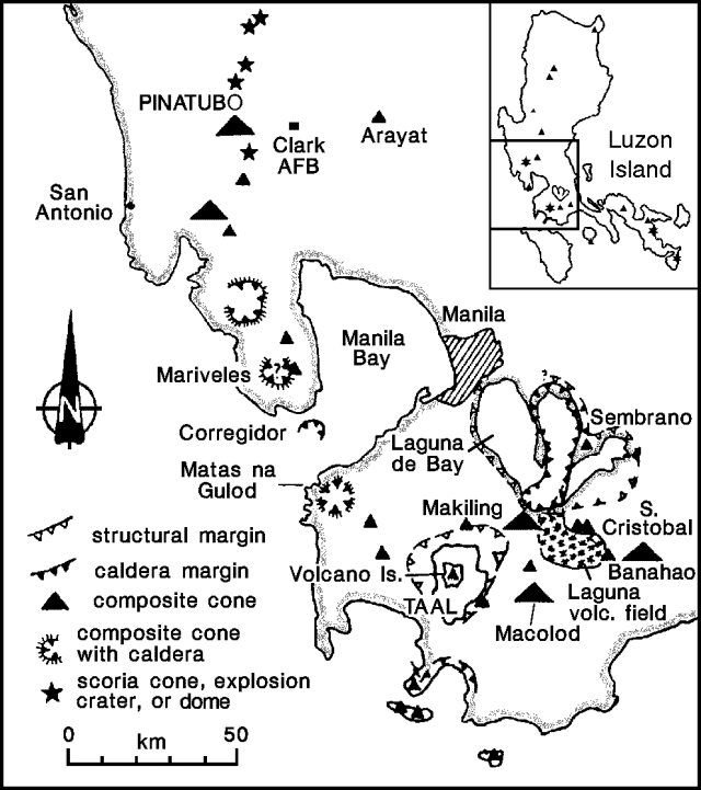 |
Figure 5. Map showing the key geologic and geographic features near Pinatubo and Taal. |
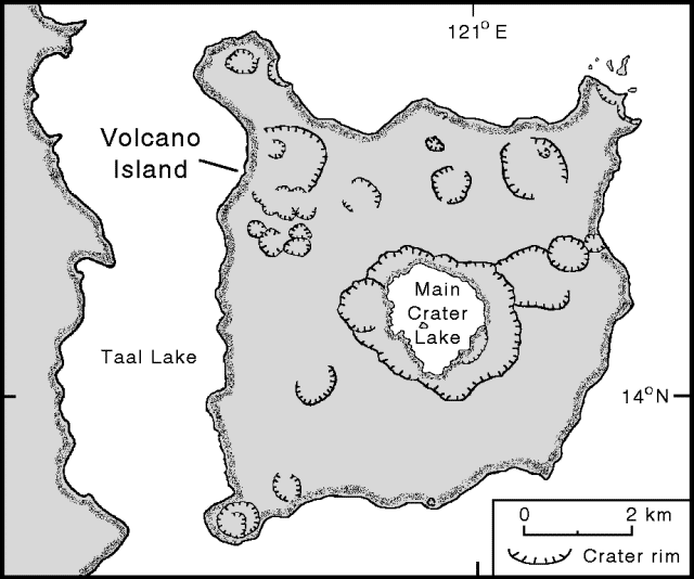 |
Figure 6. Map of Taal caldera and vicinity with land areas shaded, water areas blank (after Ruelo, 1983). |
Starting on 21 February seismic activity increased from the previous background level of 0-2 events/week to an average of 2-3 events/day. After 22 February, the seismic station located on the N shore of the main crater lake (station MRCZ) detected swarms of small high-frequency events, swarms that went undetected elsewhere, presumably because they had shallow epicenters located close to the station. Seismicity continued to grow; during the 24-hour intervals beginning at 0600 on 13 and 14 March there were 396 and 406 events, respectively. Many events took place at shallow depths (typically shallower than 3 km), beneath the central-to-SW portion of the caldera. Harmonic tremor was also reported, interpreted as due to magma intruding below the stratovolcano's central crater.
Deformation and precise leveling surveys conducted 10-22 February indicated slight inflation of the SW portion of Volcano Island. In mid-March an uplift of 14 cm was measured on the E side of the island; on 13 March both the N and SE sides inflated on the order of 10-20 cm. Around the same time researchers found two newly formed open cracks or fissures. They were approximately 70 m apart on the SE corner of Volcano Island, trending N55°W and N88°W, and were traced as discontinuous segments approaching the basal slopes of the main crater. The fissures had opened 8-10 mm, consistent with inflation of the edifice. Newhall and Dzurisin (1988) referred to extensive NE-trending ground cracks outside the caldera associated with the 1911 eruption.
Temperature measured near the bottom of the main crater lake rose abruptly on 13 February, from 30°C to 50°C, and remained high for about 12 hours before dropping back to 30°C. Eight days later a smaller 4°C rise in bottom-water temperature took place. Sometime during this interval the temperature of surface waters of the main crater lake also rose by 3°C. Temperature increases of 1-3°C began on 14 February at most of the ground probe holes in the Mount Tabaro area, on the SW side of Volcano Island (Ruelo, 1983).
On 12 March, data from acoustic sensors located about 25 m above the bottom of the main crater lake showed a significant increase in bubbling activity, which declined slightly the next day. The increased bubbling suggests significantly higher pressure beneath the stratovolcano, consistent with the postulated shallow magma chamber.
In response to growing instability PHIVOLCS elevated their alert status to Alert Level 3 on 11 March, suggesting that eruptive activity could occur within a period of weeks. In concert with the newly elevated alert level, the Manila Flight Information office issued a volcanic ash advisory in a NOTAM (Notice To Airmen, a notice to the aviation and meteorological communities) to avoid flying over the volcano. PHIVOLCS maintained Alert Level 3 as of the last available report on 15 March. They also mentioned "...partial evacuation of Volcano Island as per the recommendation of the Batangas Provincial Disaster Coordinating Council." The evacuations were a common theme in a series of reports by Reuters News Service on the situation at Taal. The reports were unclear, however, on both the number of people evacuated from Volcano Island, and the circumstances of their departure; one report told of hundreds who fled, the other told of thousands who were ordered to flee.
Several of these news reports also stated that some villagers from the island were unwilling to leave their homes. One report said "Farmers staying on the island have rented out horses to tourists from Manila so they can ride to the crater lake to photograph steam rising from rocks around the rim." The same report also said "Many sightseers have flocked to Tagaytay [on the N topographic Margin of the caldera, ~9 km N of Volcano Island], which offers a dramatic view overlooking the volcano." The Philippine president, Fidel Ramos, reportedly visited the volcano and said villagers who had refused to leave their homes would have time to flee if it erupted. These reports highlight the difficulty of establishing firm estimates on both the movement and behavior of people in a volcanic crisis.
Taal's most recent unrest took place in 1991-92 and involved elevated seismicity, deformation, and crater lake temperatures that lasted from several days to months. These conditions did not lead to eruptions. In many other cases, 34 since 1572, Taal did discharge, and in six cases these eruptions led to fatalities. In 1965 Taal ejected an estimated 9 x 10⁷ m3 of material. The eruption had a Volcanic Explosivity Index (VEI) of 4 and produced a base surge that sandblasted objects up to 8 km away. The volcano monitoring system at Taal has been improved since the 1992 crisis. Improvements include telemetry-linked sensors for seismic, temperature, radon gas, and lake geochemistry. A Japanese refraction seismic experiment recently attempted to delineate a shallow (1-2 km deep) magma chamber beneath Volcano Island that was detected in a similar experiment in 1993.
References. Newhall, C.G., and Dzurisin, D., 1988, Historical unrest at large calderas of the world: U.S. Geological Survey Bulletin 1855, v. 1, 598 p.
Ruelo, Hernulfo B., 1983, Morphological and crater development of Mt. Tabaro eruption site, Taal volcano: Philippines, Philippine Journal of Volcanology, v. 1, no. 2, p. 19-68.
Geological Summary. Taal is one of the most active volcanoes in the Philippines and has produced some powerful eruptions. The 15 x 20 km Talisay (Taal) caldera is largely filled by Lake Taal, whose 267 km2 surface lies only 3 m above sea level. The maximum depth of the lake is 160 m, with several submerged eruptive centers. The 5-km-wide Volcano Island in north-central Lake Taal is the location of all observed eruptions. The island is composed of coalescing small stratovolcanoes, tuff rings, and scoria cones. Powerful pyroclastic flows and surges have caused many fatalities.
Information Contacts: PHIVOLCS; Bureau of Meteorology, Australia; Chris Newhall, Univ. of Washington.