Report on Tongariro (New Zealand) — May 1994
Bulletin of the Global Volcanism Network, vol. 19, no. 5 (May 1994)
Managing Editor: Richard Wunderman.
Tongariro (New Zealand) Fumarole temperatures continue to decline; no deformation
Please cite this report as:
Global Volcanism Program, 1994. Report on Tongariro (New Zealand) (Wunderman, R., ed.). Bulletin of the Global Volcanism Network, 19:5. Smithsonian Institution. https://doi.org/10.5479/si.GVP.BGVN199405-241080
Tongariro
New Zealand
39.157°S, 175.632°E; summit elev. 1978 m
All times are local (unless otherwise noted)
Annual fieldwork was carried out on 30 March and 29 April 1994. Maximum fumarole temperatures had fallen to 78°C by the end of April. ... There was insufficient fumarole discharge for adequate sampling, and temperatures and pressures were at the lowest levels ever recorded. Except for minor landslide debris, no significant changes were noted in the Ngāuruhoe crater.
Tilt leveling surveys were carried out at the Tama Lakes (1.7 km SSW) and Mangatepopo (1.8 km NNW) locations on 30 March. Apparent tilt recorded at Tama Lakes during the previous 11 months represented 4 µrad of inflation, but was within the range of random fluctuations recorded since installation in 1978. At Mangatepopo approximately 14 µrad of tilt towards Ngāuruhoe (deflation) was recorded over the same period. This is ~2-3x the past noise level resulting from normal survey errors and seasonal movements. The most likely explanation, based on earlier experiences, is that two benchmarks near a walking trail have settled.
Repairs were made to the three highest crater rim stations on 30 March and two new stations were installed; two old stations are scheduled for removal after the 1995 survey. All six rim sites were surveyed for horizontal deformation on 29 April. Measurements were made by EDM and theodolite from 2 km N on Tongariro volcano. Relative movement vectors for the 1992-94 period at three stations were well within the normal noise range. Instabilities noted at the other sites resulted from various surface movements. Overall, there was no indication of recent volcanic deformation.
Geological mapping of the crater, N flank, and SW flank accomplished during these visits is part of the ongoing mapping project of the Tongariro complex.
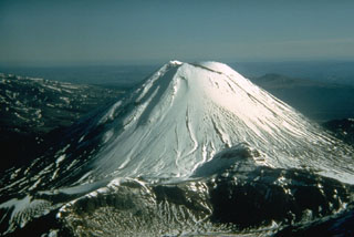
Geological Summary. Tongariro is a large volcanic massif, located immediately NE of Ruapehu volcano, that is composed of more than a dozen composite cones constructed over a period of 275,000 years. Vents along a NE-trending zone extending from Saddle Cone (below Ruapehu) to Te Maari crater (including vents at the present-day location of Ngauruhoe) were active during several hundred years around 10,000 years ago, producing the largest known eruptions at the Tongariro complex during the Holocene. North Crater stratovolcano is truncated by a broad, shallow crater filled by a solidified lava lake that is cut on the NW side by a small explosion crater. The youngest cone, Ngauruhoe, is also the highest peak.
Information Contacts: P. Otway, IGNS Wairakei.