Report on Kanaga (United States) — July 1994
Bulletin of the Global Volcanism Network, vol. 19, no. 7 (July 1994)
Managing Editor: Richard Wunderman.
Kanaga (United States) Steam-and-ash plume rises 4,500 m; enlarged hot spot on imagery
Please cite this report as:
Global Volcanism Program, 1994. Report on Kanaga (United States) (Wunderman, R., ed.). Bulletin of the Global Volcanism Network, 19:7. Smithsonian Institution. https://doi.org/10.5479/si.GVP.BGVN199407-311110
Kanaga
United States
51.923°N, 177.168°W; summit elev. 1307 m
All times are local (unless otherwise noted)
On the morning of 15 July a pilot observed steam plumes rising from multiple vents to ~600 m above the summit. FWS personnel in Adak . . . reported steam plumes during 16-22 July. A distinct hot spot . . . was seen on a satellite image from 0906 on 22 July. FWS personnel aboard the RV Tiglax observed incandescent flows on the flank of Kanaga during the night of 27-28 July; low-level steaming from the summit area was continuing. Also in late July the FWS crew saw a blocky lava flow entering the sea on the NW flank, forming a new headland and small cove. Pilots reported incandescent flows on the NW flank during the following week, and steam plumes to 1,500 m altitude. On 10 August the RV Tiglax passed within ~3 km of shore and the crew observed the two NW-flank lava flows for the first time during daylight. Steam was rising from where the flows were entering the sea, and a strong SO2 odor was detected. Satellite imagery again recorded hot spots . . . during 2-12 August.
At 0500 on 18 August, the FAA received a pilot report of "glowing" at the summit. Pilots reported a light gray, dense steam cloud at 0800 rising to 4,500 m above the summit that had a mushroom-shaped top and was trailing to the E. A satellite infrared image taken at 0836 showed a summit hot spot twice as large as that seen in recent weeks, suggesting an increase in heating associated with production of lava flows. Also visible in the image was a plume extending 15-20 km NE; enhancements of calibrated data suggested that the plume may have contained some ash. Throughout the day, pilots and FWS personnel in Adak observed an eruption cloud consisting of a white, dominantly steam portion, which rose to ~4,500 m altitude, and a vigorously roiling, gray, ash-bearing portion that rose to an estimated 2,400-3,000 m altitude. A loud rumbling, similar to the sound of a freight train, was heard in Adak all afternoon and into the evening. Prevailing winds carried the plume NE, and a light curtain of fallout was observed. Satellite images from 1133 and about 2000 on 18 August showed a plume drifting NE.
The summit hot spot, which on 18 August appeared to have doubled in size, persisted on a satellite image from 1004 on 19 August. No plume was visible that day, although cloud cover may have obscured it. FWS observers reported continued rumbling from the direction of the volcano. Kanaga continued to erupt minor amounts of ash during 20-21 August, interfering with local air traffic and dropping a light dusting of ash on the community of Adak. As of midday on 22 August, analysis of satellite imagery indicated a possible plume, containing minor ash, drifting generally ESE from the volcano over Adak. The FAA enforced a 24-km restricted flight zone around Kanaga until 1430 to minimize the possibility of aircraft encountering an ash cloud during instrument approach and departure. Poor weather obscured the volcano through the morning of 22 August. However, no ash cloud was seen from Adak as visibility improved through the day.
Pilots and other observers continued to report and photograph avalanches of hot fragmental debris cascading down the N flank of the volcano into the ocean. Although AVO has been unable to clearly discern the source of this material, it likely represents collapse of a growing lava dome or ejection of hot blocks of lava from near or within the summit crater. Based on the last eight months of activity, continuing episodes of ash eruption accompanied by avalanching of hot debris down the volcano's flanks can be expected. Depending on wind conditions and the size of a given eruptive episode, additional ashfall on Adak is possible.
. . . .The eruption has been characterized by intermittent, low-level steam and ash emissions producing plumes rarely rising over 3,000-4,500 m altitude and drifting a few tens of kilometers downwind. Although tracking of ash fallout is limited due to the remote location of Kanaga, it appears from satellite imagery that detectable fallout has been confined to within a few tens of kilometers of the volcano. On 22 August, AVO learned that several very light dustings of fine ash on the N portions of Adak had occurred over the past few months.
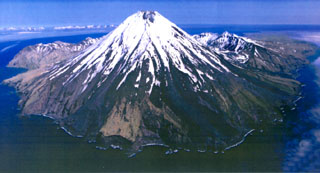
Geological Summary. Symmetrical Kanaga stratovolcano is situated within the Kanaton caldera at the northern tip of Kanaga Island. The caldera rim forms a 760-m-high arcuate ridge south and east of Kanaga; a lake occupies part of the SE caldera floor. The volume of subaerial dacitic tuff is smaller than would typically be associated with caldera collapse, and deposits of a massive submarine debris avalanche associated with edifice collapse extend nearly 30 km to the NNW. Several fresh lava flows from historical or late prehistorical time descend the flanks of Kanaga, in some cases to the sea. Historical eruptions, most of which are poorly documented, have been recorded since 1763. Kanaga is also noted petrologically for ultramafic inclusions within an outcrop of alkaline basalt SW of the volcano. Fumarolic activity occurs in a circular, 200-m-wide, 60-m-deep summit crater and produces vapor plumes sometimes seen on clear days from Adak, 50 km to the east.
Information Contacts: AVO.