Report on Asosan (Japan) — September 1994
Bulletin of the Global Volcanism Network, vol. 19, no. 9 (September 1994)
Managing Editor: Edward Venzke.
Asosan (Japan) Explosions eject mud and blocks
Please cite this report as:
Global Volcanism Program, 1994. Report on Asosan (Japan) (Venzke, E., ed.). Bulletin of the Global Volcanism Network, 19:9. Smithsonian Institution. https://doi.org/10.5479/si.GVP.BGVN199409-282110
Asosan
Japan
32.8849°N, 131.085°E; summit elev. 1592 m
All times are local (unless otherwise noted)
Activity increased at Crater 1 during September. Tremor amplitude registered at a seismic station 800 m W of the crater was 4.8 µm at about 0800 on 11 September. Three hours later, the AWS (figure 24), issued a Volcanic Advisory noting that Aso was getting restless. Another tremor, which was large enough to be felt at AWS, occurred at 1148 later that day. The floor of Crater 1 was covered by a pool of water, and intermittent mud ejection took place. Several tens of volcanic stones were found outside of the crater rim within ~300 m from the center of the crater during a visit on the morning of 14 September. These rocks were ejected by an explosion on the evening of 12 September, based on seismic records. The area within 1 km of Crater 1 was placed off-limits on 11 September by local governments through the Board for Volcanic Disaster Reduction.
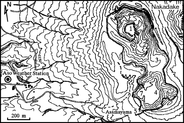 |
Figure 24. Summit area of Nakadake cone at Aso, showing numbered craters, the Aso Weather Station, and associated buildings (squares). Courtesy of JMA. |
During the rest of September, mud ejection was intermittent and volcanic tremor was frequent. On 15 and 18 September, ejected mud rose 150 m above the bottom of the crater, almost to the crater rim. On 16 and 19 September, a plume rose to a height of 1,500 m above the crater rim. Tremor was felt by personnel at AWS on 11, 15, 21, 22, and 29 September, and 1 October. The 29 September event was registered 800 m W of the crater with an amplitude of 52 µm, which is the largest reading since tremor amplitude measurements began in 1969.
The 12 September ejection of stones beyond the crater rim was the first eruptive activity since February 1993; mud ejections have been reported since 2 May 1994.
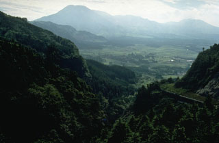
Geological Summary. The 24-km-wide Asosan caldera was formed during four major explosive eruptions from 300,000 to 90,000 years ago. These produced voluminous pyroclastic flows that covered much of Kyushu. The last of these, the Aso-4 eruption, produced more than 600 km3 of airfall tephra and pyroclastic-flow deposits. A group of 17 central cones was constructed in the middle of the caldera, one of which, Nakadake, is one of Japan's most active volcanoes. It was the location of Japan's first documented historical eruption in 553 CE. The Nakadake complex has remained active throughout the Holocene. Several other cones have been active during the Holocene, including the Kometsuka scoria cone as recently as about 210 CE. Historical eruptions have largely consisted of basaltic to basaltic-andesite ash emission with periodic strombolian and phreatomagmatic activity. The summit crater of Nakadake is accessible by toll road and cable car, and is one of Kyushu's most popular tourist destinations.
Information Contacts: JMA.