Report on Poas (Costa Rica) — September 1994
Bulletin of the Global Volcanism Network, vol. 19, no. 9 (September 1994)
Managing Editor: Edward Venzke.
Poas (Costa Rica) Phreatic and fumarolic activity; block-and-ash eruptions
Please cite this report as:
Global Volcanism Program, 1994. Report on Poas (Costa Rica) (Venzke, E., ed.). Bulletin of the Global Volcanism Network, 19:9. Smithsonian Institution. https://doi.org/10.5479/si.GVP.BGVN199409-345040
Poas
Costa Rica
10.2°N, 84.233°W; summit elev. 2697 m
All times are local (unless otherwise noted)
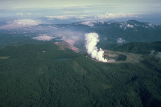
Phreatic and strong fumarolic activity between 20 July and 5 August formed a pan-like structure in the bottom of the inner lake (figure 55). Following heavy rainfall on the summit area, this structure was filled with water and mud. In the active crater, fumaroles on the S and SE sides of the lake disappeared during August, and block-and-ash eruptions formed a new small crater. The majority of the blocks fell onto the crater floor, the largest seen was 1.2 m in diameter. These eruptions ceased 5 August, but smaller gas-column discharges followed, to heights of 600 m above the lake. These discharges were noteworthy because they were rich in sulfur particulates.
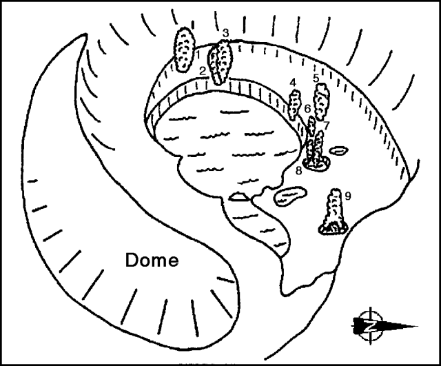 |
Figure 55. Perspective sketch looking W showing the active crater at Poás, mid-late August 1994. The dome is on the left, and the water-filled pan-like depression in the center is surrounded by active fumaroles (1-8) and a boiling mudpot (9). There is no scale, but the crater opening (rim-to-rim) is on the order of a kilometer across. Courtesy of Mauricio Mora, UCR. |
The lake in the active crater rose 1.5 m in September, covering some fumaroles. The 60°C lake was gray, muddy-looking, and clouded with suspended sulfur. Fringed by mud pots, the lake occupied the pan-like structure formed during earlier phreatic and strong fumarolic activity. Owing to the lake's rise, fumaroles in its center appeared isolated; the fumaroles to the N, NW, and W generally maintained steam columns rising ~600 m above the crater. The sound produced resembled steam escaping from a pressure-release valve when heard from the overlook.
Fumaroles on the dome were unchanged in August and September. Fumarolic activity remained strong through late September in several locations on the crater bottom, including boiling mudpots. At the beginning of September the W fumarole converted into a pan-shaped source vent constantly releasing gas and phreatic emissions to heights of 5 m. In mid-September a new fumarole appeared on the W fringe of this source vent with a moderate gas output. Toward the end of the month the gas released at the source vent decreased.
During August and September, OVSICORI-UNA recorded 3,639 and 1,524 low-frequency events, respectively. Compared to tremor duration in August (97 hours), tremor duration in September increased by 42% (to 138 hours). August tremor amplitude was 4-11 mm, with a frequency range centered around 2.3 Hz. September tremor amplitude was 3-9 mm, its frequency range was largely 1.4-2.3 Hz. In addition, a contant, deep noise source (1-3 mm amplitude) was noted during August.
On 23 September seismic instruments recorded a swarm of 11 events, of which 10 were felt by the inhabitants close to the volcano. Four of these events were located (table 5). The located events had magnitudes between 2.1 and 3.0 and epicenters in the W sectors of the volcano. Deformation measurements showed an expansion of 14 ppm during the last week of September. The localized change was found along one of the measured lines inside the crater. Outside the crater there were no significant changes. Radial inclination at the summit was very low on the two precision leveling lines. The dry tilt meters also lacked significant changes.
Table 5. Four located Poás earthquakes that occurred in the swarm on 23 September 1994. Courtesy of OVSICORI-UNA.
| Date | Time (UTC) | Magnitude | Depth (km) | Distance from the active crater |
| 23 Sep 1994 | 0126 | 3.0 | 5.4 | 2.8 km WNW |
| 23 Sep 1994 | 0134 | 2.5 | 6.7 | 2.5 km W |
| 23 Sep 1994 | 0138 | 2.4 | 7.5 | 7.5 km NW |
| 23 Sep 1994 | 0220 | 2.1 | 4.0 | 7 km SW |
Acidic atmospheric conditions were discussed for 1986-90 in an unpublished report by Fernandez and Barquero (1990). During this interval the active crater lake at Poás progressively rose in temperature from ~30 to 90°C. Compared to 1986, the lake's water also increased in dissolved sulfur (2- to 3.5-fold), chlorine (7-fold), and fluorine (~10-fold). Prevailing winds generally carried acidic gases S and SW. Measurements of total wet and dry deposition taken at both the crater rim overlook (El Mirador) and 2.3 km SW of the crater during 1986-90 indicated pH values as low as 3.5-4.1. Acidic rain disrupted strawberry, dairy, and coffee farms (2 x 10⁴ m2 severely damaged), affecting 681 farmers. It also disturbed the trees in several reforestation projects, where losses reached 95%. Farm equipment rusted rapidly. At the time of the report, studies failed to clearly demonstrate health problems, although local inhabitants complained of respiratory, skin, and eye irritations. The National Park and villages adjacent to Poás sustained damage, especially to building roofs. Areas significantly affected by the acidic atmospheric conditions reached over 24.5 ha (245,000 m2). The report cited four references to Poás work, including a paper by Brown and others (1989) proposing that ". . . crater-lake and fumarole discharge variations may well occur before significant signals on seismic and tilt networks are detected."
They further stated that ". . . maintained power output and/or low water supply could culminate in a dramatic change in activity, possibly with devastating results." A final note makes this case by example: "After continued evaporation through the dry season, Poás lake disappeared in late April 1989 accompanied by several days of continuous phreatic geysering. A dry steam/'ash' plume . . . was erupted to 200 m height on 25 April; from 30 April to early May a continuous plume reached 2 km in height with fallout over 200 km2."
References. Brown, G., Rymer, H., Dowden, J., Kapadia, P., Stevenson, D., Barquero, J., and Morales, L.D., 1989, Energy budget analysis for Poás crater lake: implications for predicting volcanic activity: Nature, v. 339, no. 6223, p. 370-72.
Fernandez, E., and Barquero, J., 1990, Erupciones de gases y sus consecuencias en el volcan Poás, Costa Rica [Eruption of gases and their consequences at Poás volcano], Costa Rica: Observatorio Vulcanologico y Sismologico de Costa Rica, Univ Nacional, Heredia, Costa Rica, 4 p.
Geological Summary. The broad vegetated edifice of Poás, one of the most active volcanoes of Costa Rica, contains three craters along a N-S line. The frequently visited multi-hued summit crater lakes of the basaltic-to-dacitic volcano are easily accessible by vehicle from the nearby capital city of San José. A N-S-trending fissure cutting the complex stratovolcano extends to the lower N flank, where it has produced the Congo stratovolcano and several lake-filled maars. The southernmost of the two summit crater lakes, Botos, last erupted about 7,500 years ago. The more prominent geothermally heated northern lake, Laguna Caliente, is one of the world's most acidic natural lakes, with a pH of near zero. It has been the site of frequent phreatic and phreatomagmatic eruptions since an eruption was reported in 1828. Eruptions often include geyser-like ejections of crater-lake water.
Information Contacts: E. Fernandez, J. Barquero, V. Barboza, R. Van der Laat, T. Marino, F. de Obaldia, and L. Carvajal, OVSICORI-UNA; G. Soto, W. Taylor, F. Arias, G. Alvarado, and R. Barquero, ICE; M. Mora, UCR.