Report on Villarrica (Chile) — October 1994

Bulletin of the Global Volcanism Network, vol. 19, no. 10 (October 1994)
Managing Editor: Richard Wunderman.
Villarrica (Chile) Minor ash-falls to SE and W; recurrent tremor
Please cite this report as:
Global Volcanism Program, 1994. Report on Villarrica (Chile) (Wunderman, R., ed.). Bulletin of the Global Volcanism Network, 19:10. Smithsonian Institution. https://doi.org/10.5479/si.GVP.BGVN199410-357120
Villarrica
Chile
39.42°S, 71.93°W; summit elev. 2847 m
All times are local (unless otherwise noted)
Beginning about 0730 in the morning of 26 September residents of the Centro de Ski Villarrica-Pucón (a ski resort) saw "scrolls of black vapor" emitted about once each minute from the main crater of Villarrica volcano. Vapor rose ~500-750 m above the summit. . . . Four such small explosions took place in the morning, the last, at 1100, coincided with a strong tremor felt at the ski resort.
Figure 3 shows the ash distribution seen by aerial observers in the upper part of the ski area (Piedra Blanca). The distribution was composed of thin ash chiefly visible due to the contrast with the white snow. One part of the ash distribution was bounded by a SE-trending band of heavier deposition. This ash fall deposit extended over 8 km, visible to the east as far as the limit of contrasting background snow.
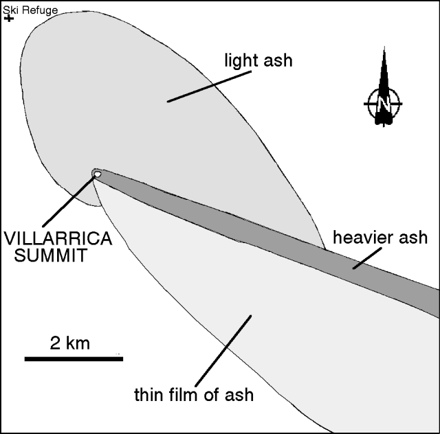 |
Figure 3. Ash distribution following the 26 September 1994 Villarrica eruption (mapping by Hugo Moreno on 26 September). |
Later on 26 September, between 2030 and 2130, observers saw incandescence above the crater that they attributed to glowing lava in the crater reflected in the fumarolic column. The next day (27 September) was partly cloud-covered, but strong fumarolic activity formed low-lying scrolls directed toward the E. Later, during a clearing in the clouds, observers saw a 500-m-long ash fall layer extending W.
Several seismic stations were installed on 26 September. Although two seismic stations were installed farther from the summit, it was not until 1630 that the station closest to the summit was installed near the Rio Voipir (at the 500-m contour, 13.5 km E of Villarrica). The record there showed continuous harmonic tremor along with other seismic events until about 2110. After that, and until 0600 on 27 September, tremor fell abruptly; however, three long-period volcanic earthquakes occurred in this interval. At 0700 harmonic tremor returned.
Starting at both 0741 and 0800 similar seismic sequences consisted of early events followed by a later event. The same sequence repeated about every 4 hours until the last one ended at 1000 on 28 September. The 4-hour sequence was interpreted as magmatic injections leading to gas-charged explosions. Thus, the main part of the eruptive episode lasted ~3.5 hours (0730-1100 on 26 September). It produced a magmatic eruption with a VEI of 1. The seismic signature associated with frequent gas-charged explosions was not previously seen at this volcano.
Geological Summary. The glacier-covered Villarrica stratovolcano, in the northern Lakes District of central Chile, is ~15 km south of the city of Pucon. A 2-km-wide caldera that formed about 3,500 years ago is located at the base of the presently active, dominantly basaltic to basaltic-andesite cone at the NW margin of a 6-km-wide Pleistocene caldera. More than 30 scoria cones and fissure vents are present on the flanks. Plinian eruptions and pyroclastic flows that have extended up to 20 km from the volcano were produced during the Holocene. Lava flows up to 18 km long have issued from summit and flank vents. Eruptions documented since 1558 CE have consisted largely of mild-to-moderate explosive activity with occasional lava effusion. Glaciers cover 40 km2 of the volcano, and lahars have damaged towns on its flanks.
Information Contacts: H. Moreno, G. Fuentealba, and M. Petit-Breuilh, SERNAGEOMIN, Temuco.