Report on Ambae (Vanuatu) — February 1995

Bulletin of the Global Volcanism Network, vol. 20, no. 2 (February 1995)
Managing Editor: Richard Wunderman.
Ambae (Vanuatu) Increased steam emissions and seismicity in early March; evacuation preparations made
Please cite this report as:
Global Volcanism Program, 1995. Report on Ambae (Vanuatu) (Wunderman, R., ed.). Bulletin of the Global Volcanism Network, 20:2. Smithsonian Institution. https://doi.org/10.5479/si.GVP.BGVN199502-257030
Ambae
Vanuatu
15.389°S, 167.835°E; summit elev. 1496 m
All times are local (unless otherwise noted)
The following report, prepared on 17 March, is from volcanologists of the Institut Francais de Recherché Scientifique pour le Developpement en Cooperation, Office de la Recherché Scientifique et Technique Outre-Mer (ORSTOM), in Vanuatu and Ecuador.
Geological setting. Aoba is the largest basaltic shield volcano in the New Hebrides arc, with the base ~3,000 m below sea level, the summit ~1,500 m asl, and a volume of ~2,500 km3 (Eggins, 1993; Gorton, 1977; Robin and others, 1993). This rainforest-covered island lies in front of the d'Entrecasteaux collision zone, between the N and S Aoba Basins along an ~N50°E fracture transverse to the arc (figure 1; see Greene and others, 1994, for more information). Two concentric summit calderas, the largest 5 km in diameter (figure 2), enclose the central crater containing the 2-km-diameter Lake Voui (Vui) (figure 3). Numerous secondary craters and cones lie along the N50°E fracture, out to the extremities of the island, where previous magma-seawater interactions have produced several maars.
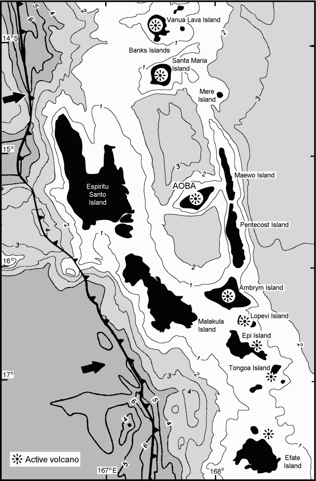 |
Figure 1. Bathymetric map of central Vanuatu showing the trench and direction of relative movement (arrows), Aoba, and other active volcanoes. Bathymetry is in kilometers. Modified from Greene and others, 1994. |
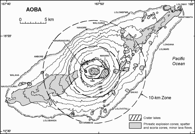 |
Figure 2. Topographic map of Aoba (Ambae) Island, central Vanuatu. Areas of Recent phreatic explosion cones, spatter and scoria cones, and minor lava flows are approximated from a 1979 geologic map by the New Hebrides Geological Survey (!;100,000). Large dashed circles are 5- and 10-km radius lines. Topographic base map courtesy of C. Robin, ORSTOM. |
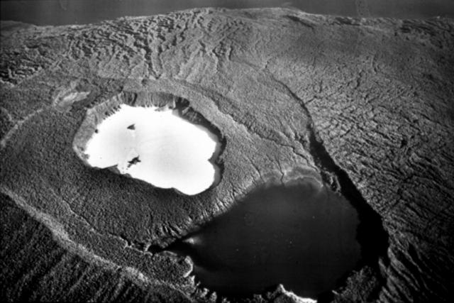 |
Figure 3. Photograph of the summit of Aoba Island looking approximately NW. Two concentric calderas enclose the main central crater, which contains the 2-km-diameter Lake Voui (white). A black lake in the E part of the caldera, Lake Manaro, is in the foreground. The photograph was taken by a U.S. pilot during World War II, provided courtesy of C. Robin, ORSTOM. |
Eruptive history. Lake Voui and the Manaro Ngoro summit explosion craters and cones formed ~420 years ago. The Ndui Ndui lava flows issued from the N50°E fissure ~300 years ago and reached the NW coast (Warden, 1970). Possible eruption-related lahars (or only secondary mudflows following heavy rains?) annihilated villages on the SE flanks of the island ~120 years ago, producing several casualties. An eruption possibly occurred in 1914 with ashfalls (?) and lahars (12 casualties). . . .
Robin and Monzier (1993, 1994) consider Aoba the most potentially dangerous volcano of the Vanuatu archipelago because of the wide distribution of very young deposits related to strong explosive eruptions. They also cite thick lahar deposits, the presence of Lake Voui, long repose periods (~300-400 years , Warden, 1970), strong degassing at the lake in 1991, and a population of ~3,500 within 10 km of the crater.
Activity in December 1994. Unusual seismicity was felt . . . during 1-7 December 1994 (BGVN 20:01). Records from ORSTOM seismic stations on Santo (70 km W) and Efate (260 km SSE) islands showed that peak activity lasted 24 hours with 13 events, the largest M 4.6 (Regnier, 1995). Crustal hypocenters were located under the S submarine base of the volcano. On 7 December, helicopter reconnaissance showed small areas of rising hot gaseous water at Lake Voui, similar to July 1991 and September 1993, but the rainforest appeared completely burned for up to several hundred meters around the crater. Despite the end of the seismic crisis, ORSTOM emphasized to the NDO the need to remain circumspect of the volcano. In mid-December, according to Robin and Monzier (1994), the following advice was given to NDO: "In the case of a resumption of volcanic activity in the summit area, it will be wise to evacuate, in a first phase, the population of coastal villages of the central part of the island (in a 10 km radius area surrounding Lake Voui) towards the less hazardous NE and SW extremities of the island. If the eruption occurs near these extremities, or spreads along fractures from central vents towards these extremities, then it might be necessary to evacuate part of the population to Santo or Maewo-Pentecost."
Activity in March 1995. According to a VANAIR pilot report on 1 March, Lake Voui was calm with gas emissions from numerous locations. The following day, the lake was steaming all over, bubbling up in the center, and its surface was rough; the pilot also reported black sediment ejections. Early on the morning of 3 March, people on Santo Island observed a gas plume rising 2-3 km above Lake Voui. Simultaneously, crustal seismicity similar to that in December 1994 was recorded.
On 4-6 March, ORSTOM geophysicists (M. Lardy and D. Charley) recorded strong continuous tremor at Ndui Ndui, ~9 km NW from the main crater. This tremor had a monochromatic signal with a 1.4 Hz mean frequency, several hours duration, and an amplitude of 3-4x background. Local observers were trained to watch the activity and the collaboration with VANAIR pilots was reinforced. As usual during the tropical summer, the top of the volcano was covered by thick clouds and rarely visible. However, on 5 March a gas plume was still visible above Lake Voui.
An island resident who stayed several days in the summit area during early March described lake levels and reported that soft mud had been blown all over the shores. On 4 and 6 March the surface of Lake Voui was at least 5.4 m higher than normal. However, on 9 March the lake was hot and steaming, and was ~4.8 m below the normal level, a change of ~10 m within 3 days. Tremor activity remained constant between 9 and 13 March, but with significantly less intensity than during 4-6 March. In addition, shallow, local micro-seismicity was noted since 11 March. During an aerial survey on 13 March, the entire lake was steaming and a strong sulfur smell had been reported around the summit area.
If activity increases in the central crater, magma-water interactions could produce falls of ash, dense lapilli, and accretionary lapilli, as well as pyroclastic flows, base surges and lahars. Lava flows may also erupt from flank fissures, N50°E or other orientations. The ORSTOM seismological team in Vanuatu will be reinforced on 17 March by the arrival of a new seismologist, and 5-7 portable seismic stations will be deployed around the island as soon as possible to improve the focal locations and delineate possible areas of attenuation. Also, a new permanent seismic station will be installed on Aoba. Daily contact is maintained between ORSTOM scientists in Vanuatu and Ecuador; the latter are prepared to move to Vanuatu if necessary.
Evacuation preparations. On 8 March, after discussions between ORSTOM geophysicists in Vanuatu and volcanologists now based in Ecuador, the following advice was given to the Vanuatu Government: ". . .The size of the gas plume observed above Lake Voui crater on March 3, 1995 probably means that magma is now rising within the volcano . . . . Thus, Aoba volcano is now dangerous and it seems necessary to envisage the evacuation of the population of coastal villages located in a 10 km radius area surrounding Lake Voui towards the less hazardous NE and SW extremities of the island . . . ."
Following this advice, Aoba Island was placed on alert and preparations for evacuations were begun. On 9 March, aircraft within a 4-km radius of Aoba up to 2.2 km altitude (7,500 feet) were restricted to scheduled flights and those approved by civil aviation or disaster office authorities. Correcting previous statements that evacuations had already started, the UNDHA reported on 17 March that villages within 10 km of the crater had been identified as threatened, and those within a 5-km radius had been placed on stand-by for immediate evacuation. Evacuation centers were identified, and all available government and several private ships were positioned to assist in a possible evacuation.
References. Eggins, S., 1993, Origin and differenciation of picritic arc magmas, Ambae (Aoba), Vanuatu: Contributions to Mineralogy and Petrology, v. 114, p. 79-100.
Gorton, M.P., 1977, The geochemistry and origin of quaternary volcanism in the New Hebrides: Geochimica et Cosmochimica Acta, v. 41, p. 1257-1270.
Greene, H.G., Collot, J.-Y., Stokking, L.B., and others, 1994, Proceedings of the Ocean Drilling Program, Scientific Results, 134: College Station, TX (Ocean Drilling Program).
Regnier, M., 1995, Rapport préliminaire sur la crise sismique d'Aoba de décembre 1994: Rapport ORSTOM, Port-Vila, 4 p.
Robin, C., and Monzier, M., 1993, Volcanic hazards in Vanuatu: Disaster Management Workshop by National Disaster Management Office, Republic of Vanuatu, 24-28 May 1993, Port-Vila, 8 p.
Robin, C., and Monzier, M., 1994, Volcanic hazards in Vanuatu: ORSTOM and Dept. of Geology, Mines and Water Resources of the Vanuatu Government report, 15 p.
Robin, C., Monzier, M., Crawford, A.J., and Eggins, S.M., 1993, The geology, volcanology, petrology-geochemistry, and tectonic evolution of the New Hébrides island arc, Vanuatu: IAVCEI Canberra 1993, Excursion guide, Record 1993 / 59, Australian Geological Survey Organisation, 86 p.
Warden, A.J., 1970, Evolution of Aoba caldera volcano, New Hebrides: BV, v. 34, no. 1, p. 107-140.
Geological Summary. The island of Ambae, also known as Aoba, is a massive 2,500 km3 basaltic shield that is the most voluminous volcano of the New Hebrides archipelago. A pronounced NE-SW-trending rift zone with numerous scoria cones gives the 16 x 38 km island an elongated form. A broad pyroclastic cone containing three crater lakes (Manaro Ngoru, Voui, and Manaro Lakua) is located at the summit within the youngest of at least two nested calderas, the largest of which is 6 km in diameter. That large central edifice is also called Manaro Voui or Lombenben volcano. Post-caldera explosive eruptions formed the summit craters about 360 years ago. A tuff cone was constructed within Lake Voui (or Vui) about 60 years later. The latest known flank eruption, about 300 years ago, destroyed the population of the Nduindui area near the western coast.
Information Contacts: C. Robin and M. Monzier (geologists) ORSTOM, Quito, Ecuador; M. Lardy (geophysicist); M. Regnier, J-P. Metaxian, R. Decourt (seismologists), and D. Charley (technical assistant), ORSTOM, Vanuatu; M. Ruiz (seismologist), Instituto Geofísico, Escuela Politécnica Nacional, Quito, Ecuador; J-P. Eissen (geologist), ORSTOM, France; BOM, Australia; UNDHA.