Report on El Chichon (Mexico) — May 1995
Bulletin of the Global Volcanism Network, vol. 20, no. 5 (May 1995)
Managing Editor: Edward Venzke.
El Chichon (Mexico) Fumarolic activity; lake level drops compared to 1993
Please cite this report as:
Global Volcanism Program, 1995. Report on El Chichon (Mexico) (Venzke, E., ed.). Bulletin of the Global Volcanism Network, 20:5. Smithsonian Institution. https://doi.org/10.5479/si.GVP.BGVN199505-341120
El Chichon
Mexico
17.3602°N, 93.2297°W; summit elev. 1150 m
All times are local (unless otherwise noted)
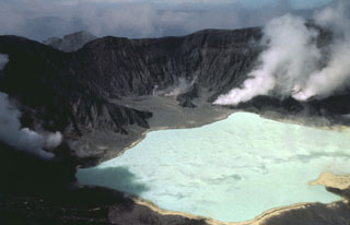
The activity and appearance of El Chichón during 17-27 May resembled that observed in 1992 and 1993. Since last visited in February 1993, several rockfalls had occurred from the inner crater wall. A major rockfall in the S part of the crater was probably associated with a 90-m-long fracture system observed in May 1992.
Lake level at El Chichón has continued to decline since 1992, dropping a total of 2 m (0.85 m from 1992 to 1993, and 1.15 m since 1993). Several terraces representing stationary lake levels were visible. The acidity and temperature of the lake water were similar to 1992 and 1993. Data were collected at two sites similar to those chosen in 1993. Site 1, which better reflected the typical ambient conditions, had a pH of 2.15 and a temperature of 33°C. Site 2 had slightly higher readings: a pH of 2.21 and a temperature of 34.5°C.
Fumarolic activity was still predominant in the N part of the crater, consistent with 1993 observations. The fumaroles produced 100°C vapor-rich emissions with abundant sulfur sublimates.
Seismicity remained normal during the visit. Two portable seismometers were set up on the moat area and run for 80 hours. During this period, 21 shallow events with coda magnitudes <1.8 were registered. Some evidence from wave form and polarity suggested both tectonic and internal explosion sources for these events.
Prior to 1982 this relatively unknown volcano was a heavily forested lava dome cluster of no greater height than adjacent non-volcanic peaks. The major 1982 high-sulfur explosive eruptions were accompanied by devastating pyroclastic flows and surges, destroying the summit lava dome and creating a new ~1-km-wide crater now containing the acidic crater lake.
Geological Summary. El Chichón is a small trachyandesitic tuff cone and lava dome complex in an isolated part of the Chiapas region in SE México. Prior to 1982, this relatively unknown volcano was heavily forested and of no greater height than adjacent non-volcanic peaks. The largest dome, the former summit of the volcano, was constructed within a 1.6 x 2 km summit crater created about 220,000 years ago. Two other large craters are located on the SW and SE flanks; a lava dome fills the SW crater, and an older dome is located on the NW flank. More than ten large explosive eruptions have occurred since the mid-Holocene. The powerful 1982 explosive eruptions of high-sulfur, anhydrite-bearing magma destroyed the summit lava dome and were accompanied by pyroclastic flows and surges that devastated an area extending about 8 km around the volcano. The eruptions created a new 1-km-wide, 300-m-deep crater that now contains an acidic crater lake.
Information Contacts: Jose Luis Macias, Juan Manuel Espindola, Zenon Jimenez, and Yuri Taran, Instituto de Geofisica, UNAM.