Report on Pinatubo (Philippines) — July 1995

Bulletin of the Global Volcanism Network, vol. 20, no. 7 (July 1995)
Managing Editor: Richard Wunderman.
Pinatubo (Philippines) Lahars force evacuations of 15,000 people
Please cite this report as:
Global Volcanism Program, 1995. Report on Pinatubo (Philippines) (Wunderman, R., ed.). Bulletin of the Global Volcanism Network, 20:7. Smithsonian Institution. https://doi.org/10.5479/si.GVP.BGVN199507-273083
Pinatubo
Philippines
15.13°N, 120.35°E; summit elev. 1486 m
All times are local (unless otherwise noted)
Continuous and intense rainfall during 28-30 July caused by the passage of a tropical storm triggered moderate to large lahars on the slopes of Mt. Pinatubo along the O'Donnell (NNE), Pasig-Potrero (SE), Santo Tomas-Marella (SW), and Bucao (NW) rivers. Minor lahar deposition along the middle and lower reaches of the O'Donnell, Santo Tomas-Marella, and Bucao river systems was confined to previous lahar-affected areas. Flooding along the inner-side of the secondary dike along the Santo Tomas River and potential isolation forced residents of Barangay Rabanes to move to a temporary evacuation center at Barangay Consuelo, both located in the town of San Marcelino, Zambales.
The greatest impact of the 28-30 July lahars was along the Pasig-Potrero river system. About 30 million cubic meters of lahar debris was deposited over a 12 km2 area (figure 33). About 25% of the sediment volume was derived from erosion of previously emplaced lahar deposits. Twenty three houses were buried under 1-4 m of debris, forcing >15,000 residents from the towns of Porac and Bacolor to evacuate. Lahars also disrupted traffic and resulted in temporary closure of the Angeles-Porac Road and the Olongapo-Gapan National Road. Geomorphologic changes along the Pasig-Potrero River included the incision of a 10-m-deep by 100-m-wide channel extending 5 km downstream from the Delta 5 watchpoint (15.5 km from Pinatubo), and net deposition starting 2 km upstream of the Angeles-Porac Road (20 km from Pinatubo) and extending 15 km downstream.
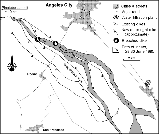 |
Figure 33. Map of the recent lahars at Pinatubo, 30 July 1995. Courtesy of PHIVOLCS. |
In a 2 August Deutsche Presse-Agentur news report, the director of PHIVOLCS stated that at least US $4 billion would be required to hold back the lahars. This figure was used by Ray Punongbayan to give the local residents a perspective of the total cost to build a properly engineered dike system to manage four active lahar channels. The estimate was based on costs to build concrete dikes in the United States and Japan, at US $1 billion per river system.
The June 1991 eruption left abundant unconsolidated ash deposits that have been mobilized as lahars in each subsequent monsoon season. Lahars occurred in the first half of July, and a secondary explosion 10 km from the crater on 11 July sent a plume to 9-10 km altitude (BGVN 20:06).
Geological Summary. Prior to 1991 Pinatubo volcano was a relatively unknown, heavily forested lava dome complex located 100 km NW of Manila with no records of historical eruptions. The 1991 eruption, one of the world's largest of the 20th century, ejected massive amounts of tephra and produced voluminous pyroclastic flows, forming a small, 2.5-km-wide summit caldera whose floor is now covered by a lake. Caldera formation lowered the height of the summit by more than 300 m. Although the eruption caused hundreds of fatalities and major damage with severe social and economic impact, successful monitoring efforts greatly reduced the number of fatalities. Widespread lahars that redistributed products of the 1991 eruption have continued to cause severe disruption. Previous major eruptive periods, interrupted by lengthy quiescent periods, have produced pyroclastic flows and lahars that were even more extensive than in 1991.
Information Contacts: J.V. Umbal, P.J. Delos Reyes, and N.M. Tungol, Philippine Institute of Volcanology and Seismology (PHIVOLCS), Department of Science and Technology (DOST), 5th & 6th Floors Hizon Building, 29 Quezon Avenue, Quezon City, Philippines; Deutsche Presse-Agentur.