Report on Merapi (Indonesia) — October 1995

Bulletin of the Global Volcanism Network, vol. 20, no. 10 (October 1995)
Managing Editor: Richard Wunderman.
Merapi (Indonesia) Pyroclastic flows travel down two river drainages
Please cite this report as:
Global Volcanism Program, 1995. Report on Merapi (Indonesia) (Wunderman, R., ed.). Bulletin of the Global Volcanism Network, 20:10. Smithsonian Institution. https://doi.org/10.5479/si.GVP.BGVN199510-263250
Merapi
Indonesia
7.54°S, 110.446°E; summit elev. 2910 m
All times are local (unless otherwise noted)
During August-October 1995 pyroclastic flows ("glowing avalanches") continued flowing down the Boyong River; others entered the Krasak River and reached ~1-1.5 km from the source. Seismic activity was dominated by multiphase and lava-avalanche (rockfall) earthquakes. The number of multiphase earthquakes increased in October to 793 events, compared to 186 in September. Earthquakes associated with lava avalanches or rock falls gradually decreased from 1,195 events in August to 806 in September and 605 in October (figure 16). Shallow volcanic (B-type) earthquakes (~1 km depth) were recorded on 25 October and a deep volcanic (A-type) earthquake (2.7 km depth) was detected on 30 October. Observations in October indicated an inflation associated with 40 µrad of tilt. Measurement of SO2 by COSPEC indicated that the emission rate during October fluctuated between 18 and 112 t/d (average 63).
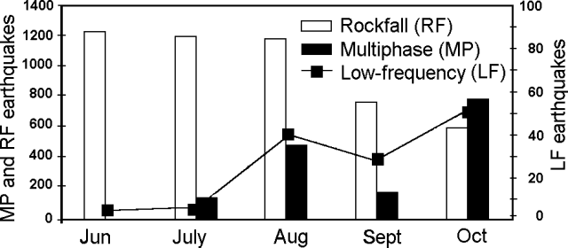 |
Figure 16. Seismicity at Merapi, June-October 1995. Courtesy of VSI. |
Geological Summary. Merapi, one of Indonesia's most active volcanoes, lies in one of the world's most densely populated areas and dominates the landscape immediately north of the major city of Yogyakarta. It is the youngest and southernmost of a volcanic chain extending NNW to Ungaran volcano. Growth of Old Merapi during the Pleistocene ended with major edifice collapse perhaps about 2,000 years ago, leaving a large arcuate scarp cutting the eroded older Batulawang volcano. Subsequent growth of the steep-sided Young Merapi edifice, its upper part unvegetated due to frequent activity, began SW of the earlier collapse scarp. Pyroclastic flows and lahars accompanying growth and collapse of the steep-sided active summit lava dome have devastated cultivated lands on the western-to-southern flanks and caused many fatalities.
Information Contacts: W. Tjetjep, VSI.