Report on Cerro Negro (Nicaragua) — December 1995
Bulletin of the Global Volcanism Network, vol. 20, no. 11 (December 1995)
Managing Editor: Richard Wunderman.
Cerro Negro (Nicaragua) Vigorous eruption produces a new cone, dome, lava flows, and large ash plumes
Please cite this report as:
Global Volcanism Program, 1995. Report on Cerro Negro (Nicaragua) (Wunderman, R., ed.). Bulletin of the Global Volcanism Network, 20:11. Smithsonian Institution. https://doi.org/10.5479/si.GVP.BGVN199512-344070
Cerro Negro
Nicaragua
12.506°N, 86.702°W; summit elev. 728 m
All times are local (unless otherwise noted)
A significant eruption in November-December followed almost six months of unrest and minor eruptive activity. During a crater visit on 13 November no precursors were observed, and on 18 November only background seismicity was recorded by the CNGN station (500 m E of the crater).
Early phase of activity, 19-22 November. Local residents first noticed explosions about the time of the onset of 30 minutes of mildly increasing seismicity detected by the CNGN station at 1145 on 19 November. Following a pause, seismicity continued to gain strength. Increasing activity was reported that afternoon by residents in Malpaisillo (~10 km N). Observations on the night of 19-20 November indicated mild Strombolian activity, with vertically directed ejecta, that was gradually increasing in strength. A Notice to Airmen (NOTAM) was issued the next day warning aviators of the volcanic activity.
Eruption tremor amplitude increased continuously and saturated the CNGN station (60 dB gain) at 0200 on the 21st. Tremor was detected on short-period seismic stations within a 30 km radius (at San Cristóbal and Momotombo volcanoes, and near the city of León). Energy release increased continuously and tremor could be felt over 1 km away, when sitting down, as a smooth rocking motion.
At 2000 on 21 November incandescent bombs were being thrown up to 300-400 m above the 1992 crater rim. Ash content was low compared with the 1992 and May-August 1995 activity, and bombs were often very large (meters across), which deformed and broke up in flight. Because of near-vertical trajectories, few bombs fell outside the crater. The new cone being built within the 1992 crater (figure 8) had a steep (>45 degrees) basal scarp, 2-5 m high, followed by a level bench and then a less steep slope (25 degrees) to its crater. Ejecta pulses maintained a frequency of 20/minute, but the size and duration of each pulse varied. From 0255 to 0310 on 22 November ejecta heights were <150 m but ash content and degassing were much higher, emitting dark clouds with each explosion. A thick, white lower plume appeared to be escaping from a new lava dome in the 1992 crater, 50 m W of the new cone (figure 8). By 0500 the eruption had regained previous intensity levels and exhibited near-constant fire-fountain-like activity, bombs were larger, and pulse frequency increased to 22/minute. The eruption continued at this level for over 4 hours.
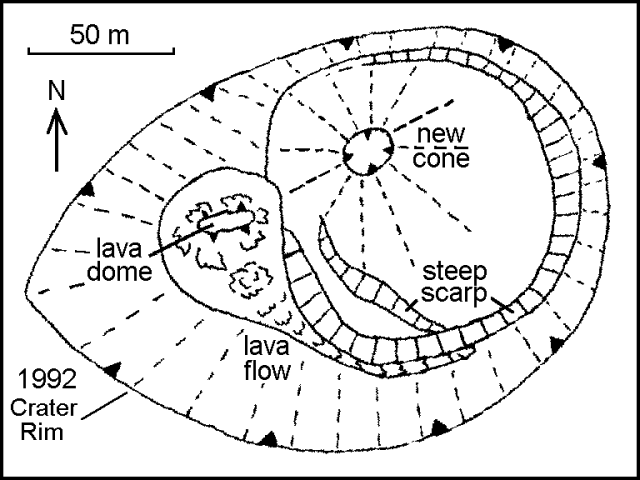 |
Figure 8. Sketch of the crater at Cerro Negro, 0700 on 22 November 1995. Drawn from photographs taken by Pedro Perez; courtesy of INETER. |
The new cone had almost reached the lip of the 1992 crater by 0700 on 22 November. At that time the lava dome emitted a small lava flow, 2-5 m wide and 50 m long, that followed the edge of the new cone towards the lowest part of the 1992 crater (figure 9). From 0930 to 1000 a series of explosions ejected material to the lower slopes of the new cone. Sand to gravel size ash fell W of the cone, but no large ejecta. Compared to the 1992 ejecta this material is highly vesicular with millimeter-size vesicles; olivine, pyroxene, and plagioclase are present, and some plagioclase crystals are 1 cm long. That evening the new cone overgrew the N rim of the 1992 crater and material began spilling towards Cerro La Mula. From 1900 to 2300 a tongue of lava spilled over the N rim of the 1992 crater. The front moved at less than 1 m/hour, but blocks constantly tumbled from the front down to the base of the main cone.
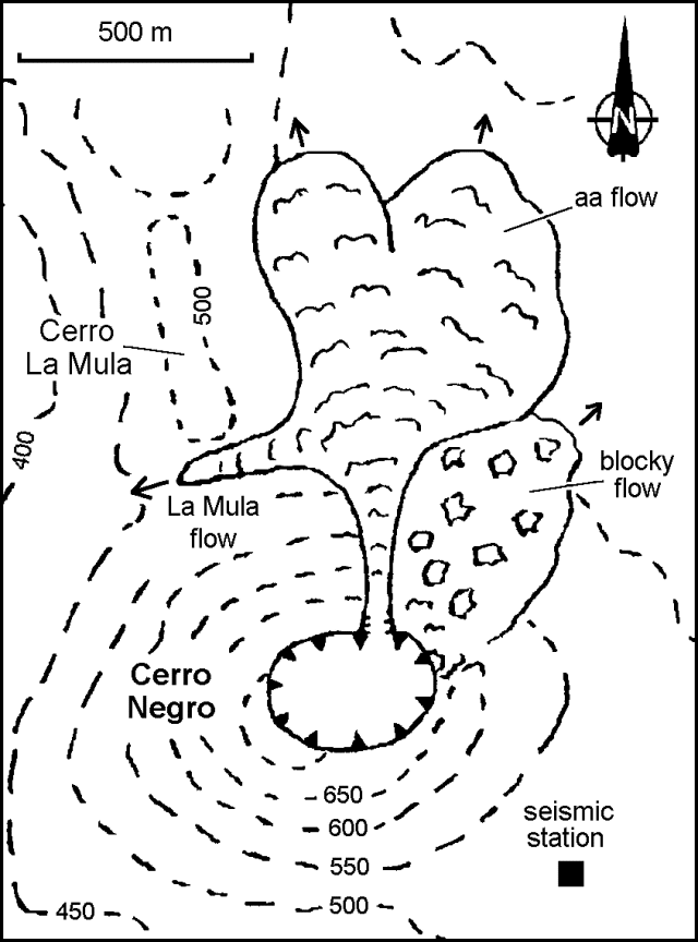 |
Figure 9. Sketch map of Cerro Negro showing active lava flows, 2000 on 23 November 1995. Drawn by B. Van Wyk de Vries; courtesy of INETER. |
Lava flows beyond the crater, 23 November. After 1400 on 23 November dark gray pulses observed from 25 km away formed a plume that rose faster and higher than on previous days, attaining several kilometers altitude. Observations were made from the seismic station after 1500. During about 1515-1525 the plume became less ash-rich, ejecta became less frequent, and strong degassing pulses were heard. When regular pulses resumed, some bombs were ejected laterally onto the flanks of the main cone. Periodic heavy falls of 1-3 cm scoria were encountered by the scientists walking under the plume 1.5 km from the cone. Red glow was visible at 1730 over Cerro La Mula, and there was a smell of burning vegetation, suggesting an active lava flow. The lava tongue was observed at 1800 between Cerro La Mula and Cerro Negro (figure 9). Later named the La Mula flow, it was ~20 m wide and 5 m thick, and advancing at ~2 m/hour.
At 1830 a 20-m-wide lava stream moved down the N flank through a small breach at a rate of ~150 m/minute from the crater rim to the base of the cone. A lava field spreading out from the base of the cone had reached ~1 km from the crater by 2000, advancing 10-30 m/hour along two 300-m-wide fronts (figure 9). To the E of the flow the volcano flank appeared to be bulging and was irregular with large blocks jutting out that occasionally fell downslope, revealing incandescent lava. It appeared to the scientists that a slow-moving 20-m-thick blocky lava flow was moving to the crater rim and collapsing down the flank; however, the shape of the flank also suggested outward bulging. The blocky lava extended at least 200 m NE from the base of the cone.
Continuous and voluminous pulses at 2000 created a fountain that sent bombs at least 600 m above the crater. Ash clouds accompanied each pulse and occasional flames of burning gas reached 100-200 m above the crater. This activity had decreased by 2045, and by 2115 pulses of bombs appeared only every 30 seconds, although continual noise suggested smaller pulses.
Of the four GPS stations set up in the vicinity of the cone, by 23 November one had been destroyed by lava and another was too dangerous to approach. Measurements at the remaining stations were within the error of the equipment (2 cm at best). However, two fresh fault scarps radial to the cone were observed on the W side with 5 cm of displacement. Tremor energy increased continuously until 1200 on 23 November, after which it maintained a constant level.
Continuing activity, 25-26 November.The eruption plume was again clearly visible on 25 November from Managua as a diffuse gray column turning horizontal at ~2,000 m. At 0900 distinct pulses of dark gray ash rose from the crater and formed mushroom shapes before drifting W and being incorporated into the plume; ashfall was reported in León and Corinto. At times only massive bombs were thrown out, while at others strong explosions sent up dense ash clouds. Ash and highly vesicular scoria
At 1100 on 25 November most bombs were still ejected vertically, but a significant number were exiting at low angles and falling low on the flanks. The new cone had grown to ~40 m across, and its top was ~30-50 m below the 1992 crater summit. Bombs fell mostly on the cone and rolled down to the base. The small breach where the 23 November lava flow exited was partly covered by a new blocky flow, which appeared to come straight N from the new cone, though no exit vent was visible. It may have been produced by accumulated, still liquid ejecta beginning to flow outwards, as seen on 22 November. The flow had advanced half way down the flank, covering another blocky flow. The dome in the crater had grown to ~100 m wide and 40 m high. Blocks were continually spalling off the dome, which also sustained a continuous rain of bombs from the new cone. Multiple small lava tongues originated from the dome. The crater dome was less pronounced on 26 November, and was blocky rather than spiny. The new cone had grown ~10 m overnight.
The two flows moving N on the 23rd had reached ~1-1.5 km from the volcano. The larger W lobe was ~400 m wide and 3-5 m thick at the front with a small lobe extending down the gully below Cerro La Mula, and another extending E into a depression in the old N lava field. The E lobe had extended into forest at the E side of the old N lava field. Over a three-hour period the flows advanced ~12 m. A low ash-covered area with a small old cinder cone separated the lobes. The sides of each flow were slowly (~1 m/hour) encroaching on this and thickening. The thick lava lobes below the dome were advancing, and many areas of the dome were glowing. The ~30-m-wide La Mula lava flow had advanced W ~500 m down a small valley and was moving at ~1 m/hour on 25 November; by 0600 on the 26th it had stopped. By 0645 the other lava fronts had advanced 20-50 m since the previous evening. The main W lobe had spread E and a large block in the middle of the flow had moved ~100 m.
Seismic tremor levels remained high through 26 November. Tremor was continuous and distinctly felt up to 1.5 km from the cone.
Satellite observations of the ash plume. Visible satellite imagery on 25 November indicated a possible low-level ash cloud at 1245 (figure 10). The height of the plume was estimated at 4,500 m altitude and was moving SW at ~30 km/hour. Another small low-level plume was seen on imagery at 0815 the next day at an estimated 2,750 m altitude and moving WSW at ~35 km/hour. Explosive activity increased on 1 December, when visible imagery at 1230 revealed a plume 18 km wide extending ~320 km W; it was estimated to be between 3,000 and 6,000 m altitude. By 0900 on 2 December, the plume extended at least 640 km W and was below 4,000 m.
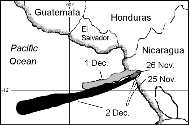 |
Figure 10. Map showing ash plumes from Cerro Negro detected on visible satellite imagery on 25-26 November, and 1-2 December 1995. Courtesy of the Synoptic Analysis Branch, NOAA/NESDIS. |
End of the eruption, early December. Explosive and effusive activity ended on 6 December. However, a lava flow was still moving N on 8 December. Isopach maps of the ashfall through 2 December (figure 11) were constructed by Markus Kesseler based on 85 GPS control points (precision +- 30 m). The 0.1 cm isopach encloses an area of ~200 km2. An estimated 12,000 people were affected by this eruption, about 6,000 of whom had been evacuated from 15 rural communities. Farmland was significantly damaged by ashfall and lava flows during the harvesting season; most of those affected were farmers and their families.
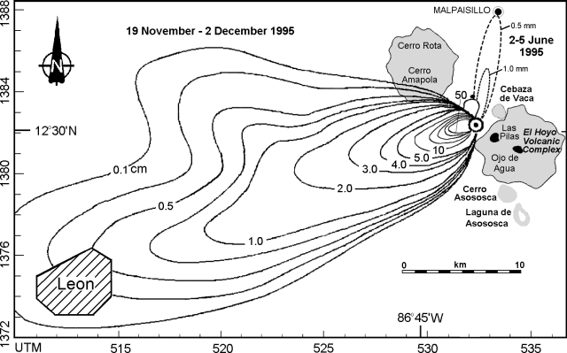 |
Figure 11. Isopach maps of ashfall from Cerro Negro, 19 November-2 December 1995. Isopachs within the 5.0 cm limit are at 10-cm intervals, up to 50 cm closest to the crater. The 2-5 June isopachs (BGVN 20:09) are shown for comparison. Courtesy of Markus Kesseler; base map courtesy of Brittain Hill. |
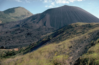
Geological Summary. Nicaragua's youngest volcano, Cerro Negro, was created following an eruption that began in April 1850 about 2 km NW of the summit of Las Pilas volcano. It is the largest, southernmost, and most recent of a group of four youthful cinder cones constructed along a NNW-SSE-trending line in the central Marrabios Range. Strombolian-to-subplinian eruptions at intervals of a few years to several decades have constructed a roughly 250-m-high basaltic cone and an associated lava field constrained by topography to extend primarily NE and SW. Cone and crater morphology have varied significantly during its short eruptive history. Although it lies in a relatively unpopulated area, occasional heavy ashfalls have damaged crops and buildings.
Information Contacts: Wilfried Strauch, Virginia Tenorio, Rolf Schick, Helman Taleno, Leonel Urbina, Cristian Lugo, and Pedro Perez, Instituto Nicaraguense de Estudios Territorales, Managua, Nicaragua; Benjamin van Wyk de Vries, The Open University, Milton Keynes, United Kingdom; Markus Kesseler, Dept. of Mineralogy, Universite de Geneve, 13 rue des Maraichers, 1211 Geneve 4, Switzerland; Michael Conway and Brittain E. Hill, Center for Nuclear Waste Regulatory Analyses, Southwest Research Institute, 6220 Culebra Rd., San Antonio, TX 78238 USA; Jim Lynch, NOAA/NESDIS Synoptic Analysis Branch (SAB) , Room 401, 5200 Auth Road, Camp Springs, MD 20746, USA; Department of Humanitarian Affairs, United Nations, Palais des Nations, 1211 Geneva 10, Switzerland.