Report on Soufriere Hills (United Kingdom) — December 1995

Bulletin of the Global Volcanism Network, vol. 20, no. 11 (December 1995)
Managing Editor: Richard Wunderman.
Soufriere Hills (United Kingdom) Dome building, minor ash eruptions
Please cite this report as:
Global Volcanism Program, 1995. Report on Soufriere Hills (United Kingdom) (Wunderman, R., ed.). Bulletin of the Global Volcanism Network, 20:11. Smithsonian Institution. https://doi.org/10.5479/si.GVP.BGVN199512-360050
Soufriere Hills
United Kingdom
16.72°N, 62.18°W; summit elev. 915 m
All times are local (unless otherwise noted)
Although there was relative quiet during October (20:10), during the first 10 days of November three large phreatic eruptions occurred. Each of these eruptions blanketed Plymouth, 4.5 km W of the active vent, with ~2 mm of ash (table 2). Dome growth within the crater started on 16 November, the estimated date when juvenile material first reached the surface, and continued through at least December. Estimates of the dome's rate of growth from 16 November to 6 December were on the order of 0.5 m3/sec.
Table 2. Summary of the daily behavior of Soufriere Hills, 1 November through 11 December 1995. The table omits most geophysical and geodedic observations, however, "eruption signal" refers to seismically determined eruptions, and "mudflow signal" refers to seismically determined mudflows. Courtesy of MVO.
| Date | Events and Comments (local time) |
| 01 Nov 1995 | Ashfall (1129). |
| 02 Nov 1995 | Ashfall in Trails, Brodericks, and surrounding areas (0118). Explosions accompanied by light ashfall in Upper Gages and Chances Peak (1923). |
| 03 Nov 1995 | Mudflow (0254); Steam-and-ash emissions resulting in light ashfall in Parson's-Amersham and Plymouth (1122). Continued enlargement of Vent 1. Steam-and- ash emission (1122). No major changes in Castle Peak. |
| 04 Nov 1995 | Eruption signal (0247), no reported ashfall. Eruption signal; one eruption generated an ash plume reaching 2.5-km high; several millimeters of ash fell in Amersham-Plymouth and S of Plymouth (1725). |
| 05 Nov 1995 | Eruption signal (0139), no reported ashfall. Mudflow toward Fort Ghaut (0214). Minor eruption without visible ash or steam (1307). Eruption signal (2030). |
| 06 Nov 1995 | Minor mudflow (0410). Increase in the size of Vent 1. Ashfall, light (0347) in crater area and steam plume, 1.5-km high. Eruption signals (1044, 1809), no ashfall. |
| 07 Nov 1995 | Eruption signal (0123), no ashfall. Ashfall (0815). Eruption signals (2018, 2358). |
| 08 Nov 1995 | Eruption signal (0935). |
| 09 Nov 1995 | Ashfall, several millimeters accumulated in areas to the W and SW of the vent (Kinsale, Amersham, Plymouth, and Richmond) (0419). |
| 10 Nov 1995 | Eruption signals (0145, 0420, 1348). Plume of ash and steam (1535), 1.5-km high, blown SW. |
| 11 Nov 1995 | Mudflows in Gages-Fort Ghaut areas (0548, 0743). Eruption signal (0733), no ash emission. |
| 12 Nov 1995 | Eruption signal (0247), no ash emission. Steam emission from several new vents SW of main activity area. Old vent reopened S of Vent 1. |
| 13 Nov 1995 | Eruption signal (0600). Minor ash and steam (1603), blown N. |
| 14 Nov 1995 | Minor ash-and-steam emission (1610). Continued steam emissions from vents first observed on 12 November. Vent closest to Castle Peak greatly increased in size, surrounded by fresh ash. |
| 15 Nov 1995 | Minor ash-and-steam emission (0900-1000). Noise of breaking rocks, small landslides, venting heard from crater. |
| 16 Nov 1995 | Poor visibility but felt earthquakes, loud venting, rock-impact sounds, and light ashfall at Chances Peak (1500), with some drifting SW into the Broderick's area. |
| 17 Nov 1995 | Episodes of light ashfall in Amersham. Landslides had partially filled the Vent 1 crater. The September dome grew in height and extended toward Chance's Peak. Vigorous steaming at the two vents between Castle Peak and the dome. |
| 18 Nov 1995 | Occasional landslides at the edge of Vent 1. |
| 23 Nov 1995 | Noises heard from crater (rock breaking and small landslides). CO2 detected in the summit area for the first time. |
| 24 Nov 1995 | Noises heard from crater (as above). |
| 26 Nov 1995 | Confirmed emergence of a new spine adjacent to the September spine and close to Castle Peak. |
| 28 Nov 1995 | Sound of breaking rocks heard from crater. |
| 29 Nov 1995 | Sound of breaking rocks heard from crater. |
| 30 Nov 1995 | Confirmed lava dome within Vent 1. |
| 01 Dec 1995 | Dome slowly growing in Vent 1 crater; attendant ash emission and rock avalanches. A second area of dome growth identified NW of September spine. Two small ash clouds drifted towards Plymouth. |
| 05 Dec 1995 | Rapid increase in the size of and the number of cracks within the new (26 November) spine. Increased emission of steam and light ash of reddish color. |
| 06 Dec 1995 | Lava dome glowing, visible from the airport. |
| 07 Dec 1995 | Reddish ashfall (0929) accompanied a small explosion. Continued slow growth of lava dome. |
| 08 Dec 1995 | Lava dome had broken along cracks. Deformation continued in the area around the September and November domes. Ash cloud (1025). |
| 09 Dec 1995 | About 20 minutes of mudflow signal recorded at Gages seismic station (0434). Explosion with light ashfall (1419, 1520). Dome growth rate slowed. |
| 10 Dec 1995 | Mudflow signal recorded at Gages seismic station (2240). |
| 11 Dec 1995 | Rusty brown ash eruptions, ashfall W of crater (0910, 1455, 1530, 1604). No major dome growth detected. Steam emitted with variable intensity at a vent close to Castle Peak. |
Small rockfalls from the flanks of the new, locally incandescent dome were witnessed on several occasions. During early December, debris from a larger rock avalanche was seen in the moat of English's Crater. As of early January, neither local avalanches nor material liberated during the failure of spines escaped the crater area. The limited mobility of the rock avalanches suggested they were not propelled by gas explosions with great overpressures. Although floods and dilute mudflows were distinguished seismically, no significant debris avalanches or pyroclastic flows occurred.
Heavy rainfall after 11 December may have triggered several small ash emissions, depositing red-brown ash on the upper W-flanks. The ash presumably consisted of non-juvenile material, from rock avalanches sloughing off the new dome, and some hot juvenile ejecta from small explosions vented in or around the new dome.
Although quantitative SO2 flux measurements were lacking, as of early December related damage to vegetation extended ~3 km downwind and 1.5 km laterally. Tree damage was severe on the upper W flank. Gases sampled at three of the established fumaroles (soufrieres) around the volcano showed no change in composition. Although gas and acid aerosol production had been at enhanced levels from mid-November to early December, air sampled in Plymouth during early December contained very little SO2.
Dome growth.Beginning on 30 November, good visibility allowed observers to watch a single dome develop from two smaller bodies (figure 6). One body was NW of the September cryptodome (an intrusion that produces a surficial bulging), and the other at Vent 1. The evolving dome had a rough blocky carapace that initially had some small (
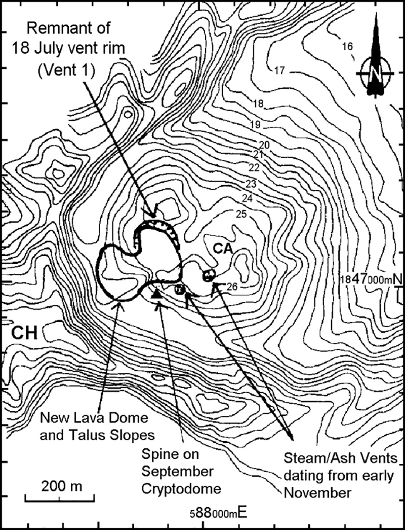 |
Figure 6. Topographic map of the crater area at Soufriere Hills showing pre-eruption morphology (thin lines) and new features (bold lines) as of 10 December 1995. Contour interval is 50 feet, values shown are feet x 100 (3.28 feet = 1 m); coordinates shown are UTM. CH indicates Chances Peak; CA indicates Castle Peak. Courtesy of MVO. |
A prominent spine on the new dome's E side grew in height until 7 December when it began to collapse. The spine's maximum vertical growth rate was estimated to be 5-8 m/day. Further dome growth at a slower rate occurred until 9-10 December, and slower growth, or a possible halt, continued as late as 13 December. On 13 December a small, radial crack on the N side of the new dome emitted steam and ash for most of the day. At least two columns reached in excess of 500 m above the crater rim.
A new batch of extruded material reached the surface on 15 December. On the 17th, in addition to widespread incandescence radiating from the new dome, observers saw a new ~ 40-m-tall spine. Between the 17th and 20th the spine grew vertically at 7 m/day, and the adjacent dome also rose, but at a slightly slower rate. The spine's growth rate during some undisclosed intervals reached up to 20 m/day. On 17 December observers also saw a narrow crack in the dome within Vent 1 that emitted glowing ejecta. Many small ash releases sent columns up to ~1.1 km above the summit.
During the week ending 27 December, several spines grew 5-10 m/day then subsequently collapsed. One spine had grown to ~15 m higher than Castle Peak (summit elevation ~910 m) prior to failing late on 25 December.
Explosions on 21 December produced a mildly convecting ash cloud that rose ~1.5 km above the volcano. Ash fell to the N, reaching the N portion of the island. Although apparently phreatic events took place in early- to mid-November, this was the most vigorous explosion since then and it may have been driven magmatically. Steam production remained constant during 21-27 December, feeding a plume that sometimes carried small amounts of ash. From 28 December to 3 January there was relative quiet and slow dome growth. Only 3 m of dome growth took place during the week, and for a least a few days after about 1 January, the dome may have ceased growing.
Deformation. Data from two electronic tiltmeters showed no significant changes during the crisis. Despite their stability, around 10 November deformation in the upper part of the volcanic edifice was recorded by EDM and GPS measurements at Castle Peak Dome and Chances Peak. Four days of significant deformation were followed on 15 November by intense seismic activity (see below). These were followed on 17 and 18 November by an upward extension of the dome that formed in September. The dome also appeared to have extended slightly towards Chance's Peak. Although visibility was poor for the next 10 days, glimpses through steam and cloud cover suggested further doming and rock avalanching. These processes influenced a wide area on the NW side of Castle Peak Dome, including the edge of Vent 1.
From mid-November until about mid-December, the rate of deformation remained very low, with daily shortening on the order of a few millimeters along most lines, even those aimed at the presumably less stable upper flanks.
The EDM data for 10-12 December showed lengthening of the lines to Castle Peak—a deflation of the edifice. Around this time, a longer interval of GPS data also showed their lines had lengthened by >1 cm overall (with some shorter-term variability). This rate was equal to or greater than the average rate during the month of October. Late December deformation measurements using GPS and EDM techniques suggested either a return to slight inflation (14-20 December) or stability (21-27 December).
Seismicity. Montserrat seismic activity falls into four categories: 1) tremor, 2) long-period events, 3) volcano-tectonic earthquakes, and 4) regional earthquakes.
After 15 November, elevated seismicity prevailed with relatively few quiet periods. The pattern appeared very similar to that seen in late September associated with the formation of a cryptodome and possibly associated with the later extrusion of a spine. The elevated seismicity was inferred to be due to a high-level magmatic intrusion.
After 27 November there was a loss of discreet, locatable events. Low-amplitude tremor became intermixed with intervals of intense, low-amplitude, long-period events; these arrived at rates of up to 5/minute but were recorded only on the closest seismic station (MGAT, Upper Gages, figure 7). In early December tremor increased somewhat at other stations farther from the crater (MLGT, Long Ground, and MBCT, Bethel); at this time amplitudes of events at Gages also increased and the RSAM seismic index rose as high as it has been since 15 November.
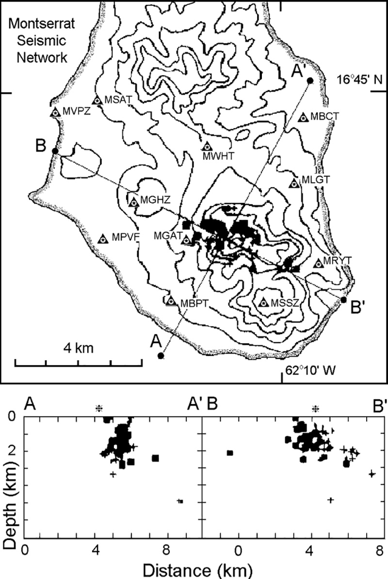 |
Figure 7. Montserrat seismic stations and epicenters shown in map and cross-section views, 10 December 1995. The intersection of the two cross sections is indicated by an asterisk. Epicenters are shown with two symbols, indicating variations in data quality (square, A and B quality; cross, C and D quality). Stations MSAT and MPVF were off line; MVPZ and MSSZ were 3-component stations. Courtesy of MVO. |
Until 9 December there were also small, frequent, long-period earthquakes. These were accompanied by low-to-variable amplitude tremor at the Gages station, but tremor disappeared from all other stations by 8 December. The number of locatable earthquakes dropped to 1-2/day, the lowest observed during this crisis. Located earthquakes were mostly volcano-tectonic and at slightly greater depths (0-5 km) than the long-period and hybrid-type earthquakes that had dominated since 24 November. High-amplitude, high-frequency tremor was recorded at station MGAT for several hours during 10-11 December; this was probably due to an increase in steam venting from several areas on Castle Peak.
The dome grew during the week ending on 13 December, with few accompanying earthquakes early on 6 December. In contrast, during 14-20 September there were 2-20 locatable earthquakes/day, many with epicenters along the N flanks at depths of 0-6 km. During the week ending on 20 December all stations registered earthquakes with emergent onsets and a dominant frequency of 2.2 Hz; these took place 5-15 times/day. Some of the earthquakes corresponded to small explosions. Heavy rains on 16-19 December triggered floods and dilute mudflows who's acoustic signals were detected by the seismic network.
Geological Summary. The complex, dominantly andesitic Soufrière Hills volcano occupies the southern half of the island of Montserrat. The summit area consists primarily of a series of lava domes emplaced along an ESE-trending zone. The volcano is flanked by Pleistocene complexes to the north and south. English's Crater, a 1-km-wide crater breached widely to the east by edifice collapse, was formed about 2000 years ago as a result of the youngest of several collapse events producing submarine debris-avalanche deposits. Block-and-ash flow and surge deposits associated with dome growth predominate in flank deposits, including those from an eruption that likely preceded the 1632 CE settlement of the island, allowing cultivation on recently devegetated land to near the summit. Non-eruptive seismic swarms occurred at 30-year intervals in the 20th century, but no historical eruptions were recorded until 1995. Long-term small-to-moderate ash eruptions beginning in that year were later accompanied by lava-dome growth and pyroclastic flows that forced evacuation of the southern half of the island and ultimately destroyed the capital city of Plymouth, causing major social and economic disruption.
Information Contacts: MVO, Plymouth; Seismic Research Unit, UWI.