Report on Merapi (Indonesia) — January 1996

Bulletin of the Global Volcanism Network, vol. 21, no. 1 (January 1996)
Managing Editor: Richard Wunderman.
Merapi (Indonesia) Increased seismicity related to lava avalanches and rockfalls
Please cite this report as:
Global Volcanism Program, 1996. Report on Merapi (Indonesia) (Wunderman, R., ed.). Bulletin of the Global Volcanism Network, 21:1. Smithsonian Institution. https://doi.org/10.5479/si.GVP.BGVN199601-263250
Merapi
Indonesia
7.54°S, 110.446°E; summit elev. 2910 m
All times are local (unless otherwise noted)
During November-December 1995 glowing avalanches down the Boyong, Krasak, and Bebeng rivers reached up to 2.5 km from the source. Seismic activity was dominated by multiphase earthquakes, low-frequency earthquakes, and lava avalanches (rockfalls). The number of multiphase earthquakes decreased from 924 in November to 152 in December; low-frequency earthquakes also decreased from 74 in November to 42 in December. Seismicity associated with lava avalanches and rock falls increased from 816 events in November to 1,078 in December (figure 17). A deep volcanic earthquake (A- type) and two tremor events were recorded in November, three shallow volcanic earthquakes (B-type) occurred in December.
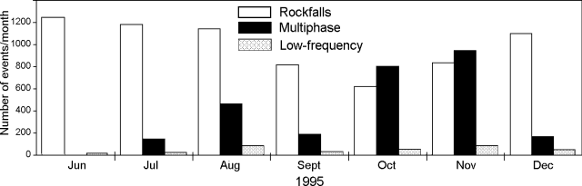 |
Figure 17. Monthly number of rockfall, multiphase, and low-frequency earthquakes at Merapi, June-December 1995. Courtesy of VSI. |
Inflation increased since 17 November from 2.5 to 10.8 µrad/day. Tilt data collected at two stations in the summit area during November and December indicated inflation of 60 and 320 µrad, respectively. The geomagnetic intensity in early December was -14.5 nTs; it then decreased to -1.5 nTs by the end of the month. The emission rate of SO2 during November fluctuated between 27 and 275 t/d, averaging 95 t/d, and the plume velocity was ~3.2-3.5 m/s. In December the emission rate decreased to 70 t/d, fluctuating between 18 and 156 t/d; plume speed was slightly higher at 3.3-3.6 m/s.
Geological Summary. Merapi, one of Indonesia's most active volcanoes, lies in one of the world's most densely populated areas and dominates the landscape immediately north of the major city of Yogyakarta. It is the youngest and southernmost of a volcanic chain extending NNW to Ungaran volcano. Growth of Old Merapi during the Pleistocene ended with major edifice collapse perhaps about 2,000 years ago, leaving a large arcuate scarp cutting the eroded older Batulawang volcano. Subsequent growth of the steep-sided Young Merapi edifice, its upper part unvegetated due to frequent activity, began SW of the earlier collapse scarp. Pyroclastic flows and lahars accompanying growth and collapse of the steep-sided active summit lava dome have devastated cultivated lands on the western-to-southern flanks and caused many fatalities.
Information Contacts: Wimpy S. Tjetjep (Director), Volcanological Survey of Indonesia (VSI), Jalan Diponegoro 57, Bandung, Indonesia; Steve O'Meara, PO Box 218, Volcano, HI 96785, USA .