Report on Popocatepetl (Mexico) — January 1996

Bulletin of the Global Volcanism Network, vol. 21, no. 1 (January 1996)
Managing Editor: Richard Wunderman.
Popocatepetl (Mexico) High steam column and variable fumarolic activity
Please cite this report as:
Global Volcanism Program, 1996. Report on Popocatepetl (Mexico) (Wunderman, R., ed.). Bulletin of the Global Volcanism Network, 21:1. Smithsonian Institution. https://doi.org/10.5479/si.GVP.BGVN199601-341090
Popocatepetl
Mexico
19.023°N, 98.622°W; summit elev. 5393 m
All times are local (unless otherwise noted)
Several months of explosive activity began at Popocatépetl on 21 December 1994. The eruption followed over a year of increased seismicity, SO2 flux, and fumarolic activity.
Beginning at 1140 on 6 January 1996, observers in Puebla saw a steam column reaching ~6.1 km (20,000 ft). Meteorologists at the Synoptic Analysis Branch of NOAA were unable to see this steam column in either the GOES visible or infrared satellite imagery. On 7 January, as viewed from towns at the volcano s base (such as Amecameca and Atlautla), strong fumarolic activity continued from the crater.
Three days later, on 10 January, a helicopter from the Procuraduria General de la Republica flew L. Cardenas, H. Delgado, C. Siebe, and others over the volcano. They noted that fumaroles in the crater appeared rather weak, including those in the field on the volcano s NW side first noticed in April 1995. New fumaroles had sprung up on the N crater rim. No emanations were seen coming from the E-flank fumarolic field.
Later, when observed in conditions of good visibility from surrounding towns on 13-14 and 17-18 January, fumarolic activity was absent. Around this time a climb to the crater rim by Cardenas and Delgado enabled them to look inside; they again saw fumarolic activity that was weaker compared to that seen during most of 1994 and 1995. Despite this weak activity, two boccas on the rim of the old inner lava dome each contained an intensely hissing fumarole. The rocks cradling the fumarole glowed a reddish color visible in daylight, attesting to very high temperatures. In addition, fresh rockslide rubble that had probably sloughed off the crater s N walls lay on the crater floor. The crater s inner E wall looked extremely altered, suggesting that it may be susceptible to additional mass wasting in the near future.
They saw more intense fumarolic activity from the crater rim than they had ever seen before, possibly indicating that the main conduit below the crater floor was in the process of sealing. In this context they advised against mountaineers climbing to the summit area, because small Vulcanian explosions could occur at any time without warning.
C. Valdés-González, G. González-Pomposo, and A. Arciniega-Ceballos (UNAM) reported on seismic activity from November 1995 through early January 1996. Activity was monitored using seismic station PPM, a part of the Mexican National Seismic Network, located on the north flank at 3,900 m elevation. Seismic events were classified as type-A, -B, and -AB (BGVN 19:01).
Type-B events dominated during 1 November-8 January, an interval when 617 were recorded. Where data are available in the interval 1 November-8 January (figure 11), the number of type-B events ranged between 3 and 18 events/day. During this same interval, type-A and -AB events registered only 7 and 6 times, respectively. Fewer than 13 type-B events/day registered during late November through early January, ending on 5 and 6 January 17 and 18 events/day were recorded, respectively.
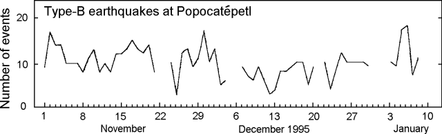 |
Figure 11. Type-B events (1.0-1.6 Hz) at Popocatépetl, 1 November 1995 to 8 January 1996. Blank where data were unavailable. Courtesy of UNAM. |
Galindo and others (1995) summarized the available SO2 flux estimates for 2 January 1994-28 January 1995. Other reports in the same volume described different facets of the volcano s behavior, including those relevant to public health (e.g. ash- aerosol dispersion).
Reference. Galindo, I., González, and Ayala, R., 1995, Emisiones de Bioxido de Azurfre del Volcan Popocatépetl, Mexico durante la erupcion de Diciembre 1994-Enero 1995; Comite Cientifico Asesor CENAPRED-UNAM, 1995, Volcan Popocatépetl Estudios Realizados Durante la crisis de 1994-1995; Capitulo VI, Aspectos GeoQuimicos y de Impacto Atmosferico, p. 245-256.
Geological Summary. Volcán Popocatépetl, whose name is the Aztec word for smoking mountain, rises 70 km SE of Mexico City to form North America's 2nd-highest volcano. The glacier-clad stratovolcano contains a steep-walled, 400 x 600 m wide crater. The generally symmetrical volcano is modified by the sharp-peaked Ventorrillo on the NW, a remnant of an earlier volcano. At least three previous major cones were destroyed by gravitational failure during the Pleistocene, producing massive debris-avalanche deposits covering broad areas to the south. The modern volcano was constructed south of the late-Pleistocene to Holocene El Fraile cone. Three major Plinian eruptions, the most recent of which took place about 800 CE, have occurred since the mid-Holocene, accompanied by pyroclastic flows and voluminous lahars that swept basins below the volcano. Frequent historical eruptions, first recorded in Aztec codices, have occurred since Pre-Columbian time.
Information Contacts: Claus Siebe and Hugo Delgado, Instituto de Geofisíca, UNAM, Cuidad Univ., 04510 D.F., México; Guillermo González- Pomposo, Carlos Valdés González, and Ana Lillian Martin del Pozzo, Departamento de Sismología y Volcanología, Instituto de Geofísica, UNAM, Cd. Universitaría, 04510, D.F., México; NOAA/NESDIS Synoptic Analysis Branch, Room 401, 5200 Auth Road, Camp Springs, MD 20746, USA.