Report on Karymsky (Russia) — March 1996
Bulletin of the Global Volcanism Network, vol. 21, no. 3 (March 1996)
Managing Editor: Richard Wunderman.
Karymsky (Russia) More details about the early January eruptions
Please cite this report as:
Global Volcanism Program, 1996. Report on Karymsky (Russia) (Wunderman, R., ed.). Bulletin of the Global Volcanism Network, 21:3. Smithsonian Institution. https://doi.org/10.5479/si.GVP.BGVN199603-300130
Karymsky
Russia
54.049°N, 159.443°E; summit elev. 1513 m
All times are local (unless otherwise noted)
According to the Institute of Volcanology (IV), the eruption on 2 January began around 0800. This activity was preceded by an upsurge in seismicity that started in April 1995. At 1926 on 31 December 1995, a M 5.8 earthquake occurred in the Kronotsky gulf, 50-60 km NE of the volcano. On 1 January at 2057 an earthquake of M 5.2 in the Karymsky region was followed at 2157 by a M 6.9 event centered ~25 km S of the volcano. During the next day there were more than 10 aftershocks of M >= 5.0. On 2 January at 1540, a group of IV volcanologists arrived by helicopter. Eruptive centers were observed near the summit and 5-6 km S in Karymsky Lake (maximum depth 115 m), which fills the Akademii Nauk caldera.
The eruption began with formation of a vent with a diameter of 20-30 m, located 50 m below the summit. Violent emissions of ash-rich gas jets rose to 1 km from another vent on the SW slope. Steam-and-gas jets, occasionally with black-colored matter, were also ejected to several hundred meters from beneath the surface of Karymsky Lake. The presumed eruptive center was 100-200 m from the shore in the NW sector of the lake. Turbulent steam-and-gas plumes rose 5-6 km above the surface from a 200-m-diameter area. Ice covering the lake had completely melted.
On 3 January the near-summit vent increased in size to 50 m in diameter. Gas and steam blasts alternated with ash ejections from the two simultaneously active vents on the volcano. Ash was usually ejected from the upper vent, and a white-colored plume was emitted from the lower vent. Ash ejections lasted 2-3 minutes, and gas blasts lasted 1.5-2 minutes. An ash-and-gas column rose 1-1.2 km and was blown E and SE by the wind. The surface of Karymsky Lake steamed intensely, sending clouds 800-1,000 m above the lake. Areas of green water were visible through breaks in the clouds, and a newly-formed black beach was seen. In the N and NE sector of the lake a narrow spit, beginning from the source of the Karymsky river and extending 250-300 m to the center of the lake, had formed. The water level in the lake had dropped a few meters. The upper reaches of the river had dried up, but on 2 January waves from the submarine eruption (up to 10 m high or more) overflowed the N shore, flooding a wide valley 1.5 km below the source. During a surveillance flight on 4 January, large areas of the valley were covered by black mud. The beach contained three fumarolic vents along the NE-trending fault zone. Within a radius of 500-800 m of the source of the Karymsky River, the surrounding snow-covered hills contained thousands of holes with diameters ranging from 10 cm to 1.5-2 m formed by lithic blocks ejected from the lake. The water level of the lake continued to fall because of intense evaporation.
Light-gray dacitic ash covered an area of about 150-200 km2. At a distance of 8 km from the volcano fractions ranging from 0.16 to 0.06 mm dominated. Estimates made by S.A. Fedotov indicated that on 2 and 3 January the ash ejection rate from the summit crater reached 3-4 tons/second.
Routine observations from 2 January through 11 February showed that the climactic phase of the subaqueous eruption continued for no more than 12-15 hours. That eruption consisted of frequent explosions during which a vapor-gas mixture with lithic material was ejected to the surface. In the N sector of the lake at the shore W of the Karymsky River, damaged trees provided evidence of two eruptive sources 500-600 m from each other. This zone contained the main concentration of bomb material ejected from the lake. A portion of the shoreline (150-200 m long and 5-15 m wide) E of the river sank several meters into the lake. The main eruption center was 500 m from the shore, but smaller peripheral centers were also observed. As a result of the eruption, in the NNW sector of the lake, a beach in the form of a wide 0.4 km2 cape was produced, as well as a narrow spit extending SE from the old shore. The length of the new shoreline was 2.4 km, and a large shoal was observed around the new peninsula. According to the preliminary estimates, the ejected deposits in the lake are at least 1 km2 in area and 5-10 x 106 m3 in volume.
Thermal springs that discharge at the S shore of Karymsky Lake were destroyed by ejecta from this eruption, and several new mud pots were formed; chemical composition of the solutions was unchanged. Near the center of the new beach, composed of sand-gravel and bomb material, a chain of five explosive vents with diameters from 1.5 to 30 m was observed. At the N end was a thermal site with a diameter of ~50 m that exhibited intense vapor emission and was covered by sublimates; visiting scientists detected a hydrogen sulfide odor. A dry funnel with a diameter of ~3 m and high gas emission at a temperature of 97°C was in the center of this site. Other explosion funnels had water at a depth of 1.2-1.5 m with temperatures from 33 to 70°C. The three funnels closest to the lake and on the opposite shore had gas emissions with temperatures of 97-98°C.
On 4 January run-off from the lake ceased owing to damming by ejected material. Analyses of water samples from the lake, river, and various hot springs in the area indicated that there had been chemical contributions to the lake water by an underlying magma body.
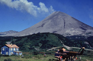
Geological Summary. Karymsky, the most active volcano of Kamchatka's eastern volcanic zone, is a symmetrical stratovolcano constructed within a 5-km-wide caldera that formed during the early Holocene. The caldera cuts the south side of the Pleistocene Dvor volcano and is located outside the north margin of the large mid-Pleistocene Polovinka caldera, which contains the smaller Akademia Nauk and Odnoboky calderas. Most seismicity preceding Karymsky eruptions originated beneath Akademia Nauk caldera, located immediately south. The caldera enclosing Karymsky formed about 7600-7700 radiocarbon years ago; construction of the stratovolcano began about 2000 years later. The latest eruptive period began about 500 years ago, following a 2300-year quiescence. Much of the cone is mantled by lava flows less than 200 years old. Historical eruptions have been vulcanian or vulcanian-strombolian with moderate explosive activity and occasional lava flows from the summit crater.
Information Contacts: G.A. Karpov, Ya.D. Muravyev, R.A. Shuvalov, S.M. Fazlullin, and V.N. Chebrov, Institute of Volcanology, Far East Division, Russian Academy of Sciences, Petropavlovsk-Kamchatsky, 683006, Russia.