Report on Deception Island (Antarctica) — April 1996
Bulletin of the Global Volcanism Network, vol. 21, no. 4 (April 1996)
Managing Editor: Richard Wunderman.
Deception Island (Antarctica) Seismicity at a level similar to that recorded in the 1994-95 survey
Please cite this report as:
Global Volcanism Program, 1996. Report on Deception Island (Antarctica) (Wunderman, R., ed.). Bulletin of the Global Volcanism Network, 21:4. Smithsonian Institution. https://doi.org/10.5479/si.GVP.BGVN199604-390030
Deception Island
Antarctica
62.9567°S, 60.6367°W; summit elev. 602 m
All times are local (unless otherwise noted)
This report describes the 1995-96 summer survey, which included geophysical, geochemical, geodetic, and volcanological work from 15 December 1995 to 27 February 1996.
Monitoring of seismicity was done with a digital seismic array composed of 30 Mark L4C-L25B geophones and a dynamic range of 16 bits. The system was deployed in the same location as the 1994-95 survey, near the Spanish station (BGVN20:04). This array was more dense than that used in the last survey in order to better cover events with frequencies greater than 10 Hz. More than 600 events were recorded, a level of seismicity similar to 1994-95. However, the average size of these events was smaller than for the previous survey. The events could be classified into several groups: regional seismicity, including intermediate-focus earthquakes; local seismicity, a few earthquakes with S-P time less than 5 seconds and M lesss than 2.5; volcanic tremors; long-period events; and hybrids, volcanic signals that contain long-period events and small earthquakes with S-P time less than 1 second. Two additional vertical component seismic stations were used, one analog on thermic drum and the other digital with a continuous register system and dynamic range of 24 bits. Regional seismicity was also monitored by another array deployed on Livingston Island, near the Spanish Antarctic "Juan Carlos I" Station, 35 km from Deception Island. Local activity at Deception Island was mainly grouped in several short (no longer than 12 hours) seismic swarms.
Continuous recording was made of magnetic field intensity using two Proton magnetometers at Deception Island and a third on Livingston Island used as a reference station. A variometric station was operated with one of the proton magnetometers. The gravimetric and GPS net was re-occupied and the network was enlarged with a new point close to the Spanish "Gabriel de Castilla" station. In order to do a paleomagnetic study some representative rock samples were collected. Systematic monitoring of fumarolic activity continued, and during this survey new areas were measured. Temperatures of fumaroles and hot soils remained stable with respect to those measured in the last survey. Anhydrous gas compositions were mainly CO2 (96-99%) and H2S (0.2-3.9%), with no SO2 detected.
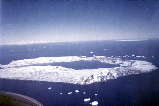
Geological Summary. Ring-shaped Deception Island, at the SW end of the South Shetland Islands, NE of Graham Land Peninsula, was constructed along the axis of the Bransfield Rift spreading center. A narrow passageway named Neptunes Bellows provides an entrance to a natural harbor within the 8.5 x 10 km caldera that was utilized as an Antarctic whaling station. Numerous vents along ring fractures circling the low 14-km-wide island have been reported active for more than 200 years. Maars line the shores of 190-m-deep Port Foster caldera bay. Among the largest of these maars is 1-km-wide Whalers Bay, at the entrance to the harbor. Eruptions during the past 8,700 years have been dated from ash layers in lake sediments on the Antarctic Peninsula and neighboring islands.
Information Contacts: A. García and R. Abella, Departamento de Volcanología, Museo Nacional de Ciencias Naturales, C.S.I.C., José Gutiérrez Abascal No. 2, 28006 Madrid, Spain; J.M. Ibañez, F. Vidal, and J. Almendros, Instituto Andaluz de Geofísica, Apartado 2145, Univ. Granada, Granada, Spain; C. Risso, A. Caselli, and A. Baraldo, Instituto Antartico Argentino, Cerrito 1248, Buenos Aires, Argentina; M. Berrocoso, Real Instituto y Observatorio de la Armada, San Fernando, Cadiz, Spain.