Report on Kilauea (United States) — May 1996

Bulletin of the Global Volcanism Network, vol. 21, no. 5 (May 1996)
Managing Editor: Richard Wunderman.
Kilauea (United States) Surface flows, ocean entries, and bench collapses; summit inflation episode
Please cite this report as:
Global Volcanism Program, 1996. Report on Kilauea (United States) (Wunderman, R., ed.). Bulletin of the Global Volcanism Network, 21:5. Smithsonian Institution. https://doi.org/10.5479/si.GVP.BGVN199605-332010
Kilauea
United States
19.421°N, 155.287°W; summit elev. 1222 m
All times are local (unless otherwise noted)
Surface flows were limited to the area below 180 m elevation in late March and early April (figure 100). Through the end of March, the Kamokuna ocean entry exhibited frequent explosive activity. On 6 April the volume of lava entering the ocean diminished as breakouts from the tube increased. By the 8th, the entry was producing a moderate-sized plume, and many small pahoehoe flows were active on the coastal plain. Most of the activity during 9-22 April took place below 165 m elevation, near the base of Pulama Pali. The surface flows on the coastal flats below Paliuli entered the ocean, forming three new entries in addition to the long-lived Kamokuna entry. On 9 April, surface flows entered the sea at the E end of the 1994 Lae'apuki bench (figure 100). Another flow entered the sea in the Kamoamoa area on 15 April, about halfway between the E Lae'apuki and Kamokuna entries. On the 22nd, a small lobe of the flow feeding the E Lae'apuki entry branched off to the W and produced a small new entry. The Pu`u `O`o pond was ~80 m deep as of 18 April and had divided into two active areas separated by a 30-m-wide segment of stationary crust.
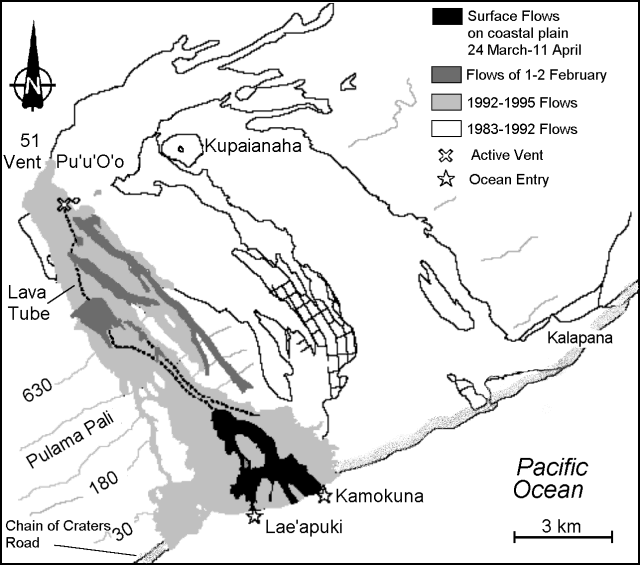 |
Figure 100. Map of recent lava flows from Kīlauea's east rift zone, April 1996. Contours are in meters and the contour interval is approximately 150 m. Courtesy of the USGS Hawaiian Volcano Observatory. |
The three active ocean entries were mostly nonexplosive from 23 April to 6 May. On the night of 28 April a large collapse of the Kamokuna bench removed a piece roughly 100 m wide by 400 m long. Surface flow activity was concentrated on the coastal plain. A moderate size "rockfall" registered on 2 May at local seismic stations, suggesting a possible collapse near Pu`u `O`o.
Surface flows during 7-20 May were diminished compared to those of previous weeks and limited to small, short-lived pahoehoe breakouts on the coastal plain inland of the Lae'apuki ocean entry. Lava continued to enter the ocean at Lae'apuki, Kamoamoa, and Kamokuna, with only 10-20% of the total volume entering at Kamoamoa. A major bench collapse at Kamoamoa on 16 May removed the entire bench, along with a significant piece of older inland terrain, for a total area of 375 x 60 m. Coastal explosions were recorded on 9 and 16 May, possibly related to bench activity. The lava pond inside Pu`u `O`o was visible on 16 May and appeared unchanged at a level of 80-90 m below the rim.
On the afternoon of 11 May, two short bursts of rapid summit inflation during a three-hour period were accompanied by shallow seismic tremor up to 6x background level. They were followed by four hours of deflation. This event did not noticeably affect the location or volume of lava flows on the east rift zone.
Through 29 May the eruption continued with three active ocean entries and small pahoehoe breakouts on the coastal plain from the lava tube supplying the Kamoamoa entry. A large pahoehoe sheet flow was observed at 180 m elevation on 29 May. On 29-30 May the eruption gradually shut down over 18 hours. By the morning of 30 May, the ocean entries had died and the 13th pause of Episode 53 had begun. During the pause, the level of the lava pond in Pu`u `O`o cone fluctuated by as much as 30 m, rising to a high point of 58 m below the rim on 3 June. Lava also appeared on the floor of the Great Pit in the outer wall of the cone. This pause in the eruption lasted until 4 June.
Seismicity. Eruption tremor continued with amplitudes averaging ~2-3x background level from 26 March through 3 June. There were three episodes of weak, deep tremor from a SW source on 31 March, 2 April, and 5 April. A fourth tremor of moderate size from the same source occurred on 7 April. Daily counts of shallow, long-period summit events were moderate to low with a maximum of 119 on 27 March. Microearthquake counts then remained generally low beneath the summit and rift zones through 20 May. Shallow, long-period microearthquake counts increased during 21-22 May and again from 30 May to 3 June. A flurry of shallow earthquakes at the uppermost end of the Upper east rift zone began on 30 May. High counts persisted and peaked on 3 June, with >200 events for the day. The number of short-period events was low beneath the summit from 21 May to 3 June.
Geological Summary. Kilauea overlaps the E flank of the massive Mauna Loa shield volcano in the island of Hawaii. Eruptions are prominent in Polynesian legends; written documentation since 1820 records frequent summit and flank lava flow eruptions interspersed with periods of long-term lava lake activity at Halemaumau crater in the summit caldera until 1924. The 3 x 5 km caldera was formed in several stages about 1,500 years ago and during the 18th century; eruptions have also originated from the lengthy East and Southwest rift zones, which extend to the ocean in both directions. About 90% of the surface of the basaltic shield volcano is formed of lava flows less than about 1,100 years old; 70% of the surface is younger than 600 years. The long-term eruption from the East rift zone between 1983 and 2018 produced lava flows covering more than 100 km2, destroyed hundreds of houses, and added new coastline.
Information Contacts: Hawaiian Volcano Observatory (HVO), U.S. Geological Survey, PO Box 51, Hawaii National Park, HI 96718, USA.