Report on Rabaul (Papua New Guinea) — June 1996

Bulletin of the Global Volcanism Network, vol. 21, no. 6 (June 1996)
Managing Editor: Richard Wunderman.
Rabaul (Papua New Guinea) Eruptions wane, stop, then resume
Please cite this report as:
Global Volcanism Program, 1996. Report on Rabaul (Papua New Guinea) (Wunderman, R., ed.). Bulletin of the Global Volcanism Network, 21:6. Smithsonian Institution. https://doi.org/10.5479/si.GVP.BGVN199606-252140
Rabaul
Papua New Guinea
4.2459°S, 152.1937°E; summit elev. 688 m
All times are local (unless otherwise noted)
From December to April, Tavurvur continued fairly steady eruptive activity. During May emissions became more variable. In June Tavurvur's summit emissions waned, stopped for several days, then resumed.
On 1-2 June Tavurvur produced weak-to-moderate explosions at irregular intervals, but these became more frequent on 4-5 June. The explosions generated pale- to dark-gray ash-and-vapor clouds that rose 400-2,000 m above the crater rim. The clouds blew N and NW and produced ashfalls. Between 3 and 5 June, explosions were accompanied by roaring noises.
On 5 June, the number of earthquakes dropped rapidly, reaching the lowest level in six months and remaining low until 29 June (figure 27). During 5-29 June observers saw white- to pale-gray vapor clouds rising ~1 km; these clouds blew N, NW, and W. Moderate explosions 1-2 times/day caused regular warnings to aircraft in the vicinity. For example, on 10 June a SIGMET from Port Moresby noted volcanic ash to below 5,600 m altitude. For a period of six days (11-16 June), no emissions took place from the summit, but explosions resumed on 17 June.
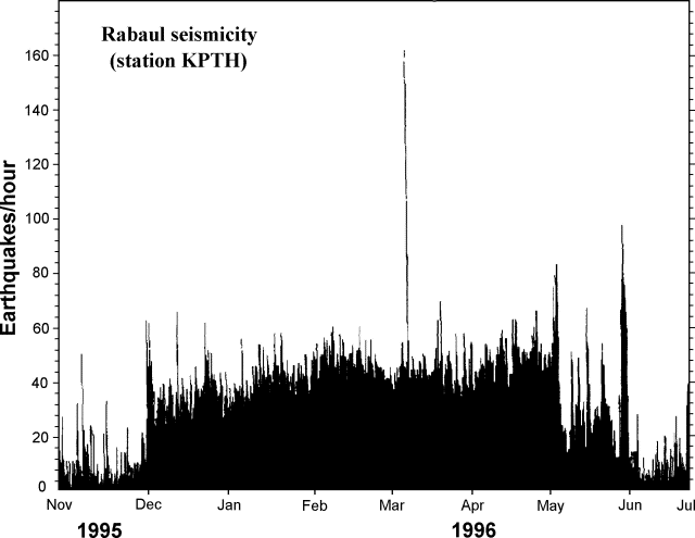 |
Figure 27. Rabaul seismicity for the period November 1995-June 1996. Courtesy of RVO. |
Ground deformation changes were low for the first half of June. After 13 June (figure 28), however, rapid radial inflation (to the N of Tavurvur) was recorded by the Matupit (MPT) electronic tiltmeter 2 km W of Tavurvur. Inflation was also recorded by a water-tube tiltmeter at Sulphur Creek (3.3 km NW). Sea-shore leveling measurements near Tavurvur have showed slow uplift since September 1995. The total inflation recorded at MPT was >52 µrad. Forty-two µrad were recorded in four days, the highest recorded rate since electronic tiltmeters were installed in October 1994.
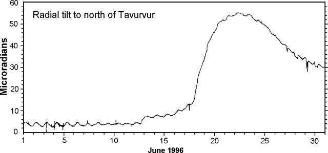 |
Figure 28. Inflationary tilt at Rabaul in June 1996, recorded by the Matupit (MPT) electronic tiltmeter 2 km W of Tavurvur. Courtesy of RVO. |
Following the rapid inflation indicated by the electronic tiltmeter, it was expected that a higher level of eruptive activity would commence. It did so later in the month when activity similar to that in the past six months resumed. Frequent explosions sent ash clouds to 400-1,000 m above the crater rim, some accompanied by loud roaring noises. These explosions continued through the end of June.
Seismicity in June consisted of 1,575 explosion earthquakes, 10 volcanic tremors, and 11 high-frequency earthquakes. The number of explosion earthquakes was the lowest since December 1995. Four high-frequency earthquakes were located to the NE of the caldera, four struck in the W part of the area delineated by the pre-1994 caldera seismicity, and the rest were scattered elsewhere.
Geological Summary. The low-lying Rabaul caldera on the tip of the Gazelle Peninsula at the NE end of New Britain forms a broad sheltered harbor utilized by what was the island's largest city prior to a major eruption in 1994. The outer flanks of the asymmetrical shield volcano are formed by thick pyroclastic-flow deposits. The 8 x 14 km caldera is widely breached on the east, where its floor is flooded by Blanche Bay and was formed about 1,400 years ago. An earlier caldera-forming eruption about 7,100 years ago is thought to have originated from Tavui caldera, offshore to the north. Three small stratovolcanoes lie outside the N and NE caldera rims. Post-caldera eruptions built basaltic-to-dacitic pyroclastic cones on the caldera floor near the NE and W caldera walls. Several of these, including Vulcan cone, which was formed during a large eruption in 1878, have produced major explosive activity during historical time. A powerful explosive eruption in 1994 occurred simultaneously from Vulcan and Tavurvur volcanoes and forced the temporary abandonment of Rabaul city.
Information Contacts: D. Lolok, and C. McKee, Rabaul Volcano Observatory (RVO), P.O. Box 385, Rabaul, Papua New Guinea; Jim Lynch, NOAA/NESDIS Synoptic Analysis Branch (SAB), Room 401, 5200 Auth Road, Camp Springs, MD 20746, USA.