Report on Kilauea (United States) — September 1996

Bulletin of the Global Volcanism Network, vol. 21, no. 9 (September 1996)
Managing Editor: Richard Wunderman.
Kilauea (United States) Eruptive activity continues; ocean entry and lava bench collapses
Please cite this report as:
Global Volcanism Program, 1996. Report on Kilauea (United States) (Wunderman, R., ed.). Bulletin of the Global Volcanism Network, 21:9. Smithsonian Institution. https://doi.org/10.5479/si.GVP.BGVN199609-332010
Kilauea
United States
19.421°N, 155.287°W; summit elev. 1222 m
All times are local (unless otherwise noted)
During August and September, the eruption along the east rift zone continued without significant change and flows entered the ocean only at Lae`apuki in Hawaii Volcanoes National Park (figure 101). During the first ten days of August, the lava pond within Pu`u `O`o was sluggish and ~100 m below the lowest part of the rim. Glows from the pond reflecting off the fume cloud over the cone were often seen at night. After a short eruptive pause on 21 August, most of the lava was confined to tubes all the way to the sea, with only a few small surface flows from breakouts. Shortly after midnight on 29 August, a large collapse removed two-thirds of the active lava bench at Lae`apuki. During the early morning of 19 September, a large block of the Lae`apuki bench slid into the ocean. Sufficient energy was transferred to the ground for the HVO seismic network to detect the event, which lasted for eight minutes.
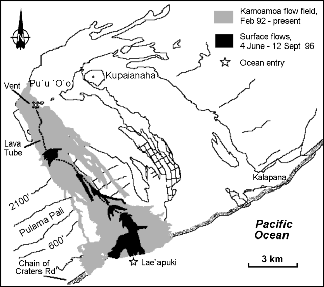 |
Figure 101. Map of recent lava flows from Kīlauea's east rift zone, June-September 1996. Contours are in feet. Courtesy of the Hawaiian Volcano Observatory, USGS. |
The lava flow field from this eruption that began in 1983 covers 23,475 acres, and ~820 acres of the flow field have been resurfaced by new lava since the beginning of June, when the eruption restarted after a five-day pause (BGVN 21:05). A total of 540 acres of new land has been added to the island since lava began entering the ocean in late 1986. As has been the case with other long-lived ocean entries, bench collapses at Lae`apuki have increased in frequency and are occurring about every two weeks. After each collapse, a severed lava tube or incandescent fault scarp is exposed and violent explosions follow. Types of explosive events observed at Lae`apuki after mid-August included sudden rock blasts, sustained and powerful steam jets, lava fountains, and "bubble-bursts" from holes in the tube above the entry.
Geological Summary. Kilauea overlaps the E flank of the massive Mauna Loa shield volcano in the island of Hawaii. Eruptions are prominent in Polynesian legends; written documentation since 1820 records frequent summit and flank lava flow eruptions interspersed with periods of long-term lava lake activity at Halemaumau crater in the summit caldera until 1924. The 3 x 5 km caldera was formed in several stages about 1,500 years ago and during the 18th century; eruptions have also originated from the lengthy East and Southwest rift zones, which extend to the ocean in both directions. About 90% of the surface of the basaltic shield volcano is formed of lava flows less than about 1,100 years old; 70% of the surface is younger than 600 years. The long-term eruption from the East rift zone between 1983 and 2018 produced lava flows covering more than 100 km2, destroyed hundreds of houses, and added new coastline.
Information Contacts: Hawaiian Volcano Observatory (HVO), U.S. Geological Survey, PO Box 51, Hawaii National Park, HI 96718, USA (URL: http://www.soest.hawaii.edu/hvo/).