Report on Ijen (Indonesia) — June 1997
Bulletin of the Global Volcanism Network, vol. 22, no. 6 (June 1997)
Managing Editor: Richard Wunderman.
Ijen (Indonesia) Late-June interval of increased seismicity; lake color changes
Please cite this report as:
Global Volcanism Program, 1997. Report on Ijen (Indonesia) (Wunderman, R., ed.). Bulletin of the Global Volcanism Network, 22:6. Smithsonian Institution. https://doi.org/10.5479/si.GVP.BGVN199706-263350
Ijen
Indonesia
8.058°S, 114.242°E; summit elev. 2769 m
All times are local (unless otherwise noted)
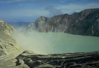
Not long after a Jakarta newspaper reported increased fumarolic activity and a large number of earthquakes, Dali Ahmad of the Volcanological Survey of Indonesia (VSI) reported that seismic activity had been on the rise since about 27 June. He also noted that the color of the water in Kawah Ijen crater lake had changed, and one or more workers near the summit reported dizziness and headaches. Ahmad closed by saying that seismicity later returned to normal.
Geologist Steve Mattox, visiting around late June, reported seeing gas bubbles and areas of upwelling in the lake. He noted that on 29 June the summit area was closed to public access after birds were seen falling into the water.
Reference. Pasternack, G.I., and Varekamp, J.C., 1994, The geochemistry of Keli Mutu volcanic lakes, Flores, Indonesia: Geochem. Journal 28, p. 243- 262.
Geological Summary. The Ijen volcano complex at the eastern end of Java consists of a group of small stratovolcanoes constructed within the 20-km-wide Ijen (Kendeng) caldera. The north caldera wall forms a prominent arcuate ridge, but elsewhere the rim was buried by post-caldera volcanoes, including Gunung Merapi, which forms the high point of the complex. Immediately west of the Gunung Merapi stratovolcano is the historically active Kawah Ijen crater, which contains a nearly 1-km-wide, turquoise-colored, acid lake. Kawah Ijen is the site of a labor-intensive mining operation in which baskets of sulfur are hand-carried from the crater floor. Many other post-caldera cones and craters are located within the caldera or along its rim. The largest concentration of cones forms an E-W zone across the southern side of the caldera. Coffee plantations cover much of the caldera floor; nearby waterfalls and hot springs are tourist destinations.
Information Contacts: Dali Ahmad, Volcanological Survey of Indonesia, Jalan Diponegoro 57, Bandung, Indonesia; Steve Mattox, 44 Robinson St., Nedlands, WA 60009 Australia; Johan C. Varekamp, Department of Earth & Environmental Sciences 265 Church Street, Wesleyan University Middletown, CT 06459-0139 USA.

