Report on Kilauea (United States) — July 1997

Bulletin of the Global Volcanism Network, vol. 22, no. 7 (July 1997)
Managing Editor: Richard Wunderman.
Kilauea (United States) Fountaining from Pu`u `O`o vents; lava flows reach ocean again
Please cite this report as:
Global Volcanism Program, 1997. Report on Kilauea (United States) (Wunderman, R., ed.). Bulletin of the Global Volcanism Network, 22:7. Smithsonian Institution. https://doi.org/10.5479/si.GVP.BGVN199707-332010
Kilauea
United States
19.421°N, 155.287°W; summit elev. 1222 m
All times are local (unless otherwise noted)
Eruptive activity continued at the Pu`u `O`o Crater from mid-May through mid-August 1997. The 55th episode of Kīlauea's 14.5-year-long East rift zone eruption began on 24 February 1997 after a 24-day hiatus in activity. This hiatus followed a brief fissure eruption at Napau Crater in late January 1997. The last long hiatus was in mid-1986, when volcanism switched from episodic 300- to 500-m-high fire fountains to continuous effusion. Episode 55 has seen shifting vent locations on the flanks of the Pu`u `O`o cone and a build-up of the lava shield. The lava pond within the Pu`u `O`o crater has intermittently risen to produce flows on its E and W margins. Surface activity was limited in the early days of Episode 55, occurring only deep within the Pu`u `O`o crater. On 28 March the lava level in the Pu`u `O`o crater rose and moved through lava tubes that fed small cones just S of the cone (BGVN 22:04). Eruptive activity in recent months has been focused at a spatter cone in Pu`u `O`o and vents on the S exterior flank of the crater.
Eruptive pauses during May. From mid-April through 9 May most of the lava erupted on the S and SW flanks of the Pu`u `O`o cone ponded near its base. These ponded flows were responsible for most of the glow seen at night and frequently fed channeled aa flows S and SE. The longer flows advanced as far as 2.6 km. Lava issued from two areas on the SW flank of the cone, both of which were topped by spatter cones 10-12 m high. A pit crater below one of these spatter cones intermittently filled with lava and overflowed.
Beginning on 10 May and continuing through the 15th there were eruptive pauses for periods of up to 10 hours. A small new vent became active on 12 May (figure 110) midway between the "55 Spatter Cone" (a vent that became active on 28 March; BGVN 22:03) and the "Uplift" vent (a vent that became active on 17 April; BGVN 22:04). Following a 15-hour pause on 23 May, activity resumed with fountaining from the 55 Spatter Cone, followed by brief periods of quiescence. Multiple flows from two active vents on the S flank of the Pu`u `O`o cone fed aa flows that traveled 1.5 km (figure 111). Occasional fountains up to 15 m high were observed from the flank vents. Activity within Pu`u `O`o raised the floor of the crater to within 10 m of the lowest section of the rim.
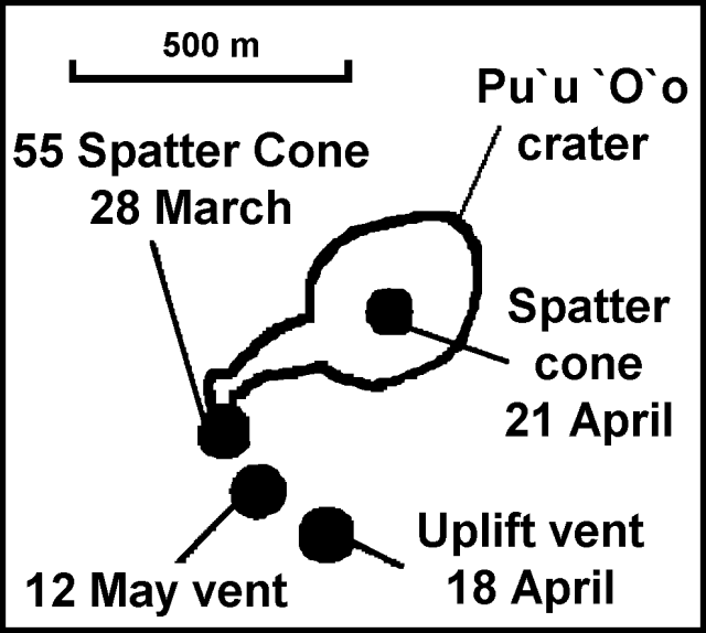 |
Figure 110. Sketch map showing four new vents in the Pu`u `O`o crater area of Kīlauea, 28 March-12 May 1997. Courtesy of the USGS Hawaiian Volcano Observatory. |
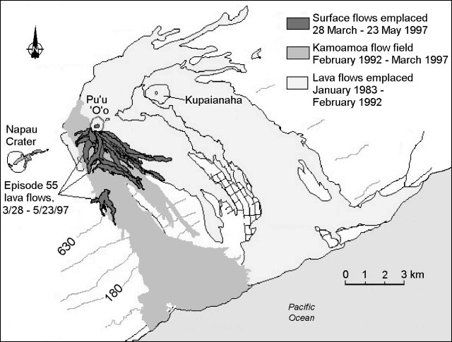 |
Figure 111. Map of recent lava flows from Kīlauea's east rift zone, 23 May 1997. Contours are in meters and the contour interval is approximately 150 m. Courtesy of the USGS Hawaiian Volcano Observatory. |
Activity during June and early July. On 2 June several earthquakes (up to M 3.5) were felt in the Namakani Paio campground area of the National Park. In the first four hours of the swarm 60 earthquakes were located. Early in the first week of June vents on the SW flank of Pu`u `O`o fed flows that traveled up to 1.5 km SE from the cone. As activity from the SW flank vents waned, a W-flank vent restarted early on 4 June and fed a flow moving NW that burned trees in the national park. Occasional fountains up to 40 m high were observed from the W vent.
During 6-13 June the lava flow field expanded N and E of the shield for the first time since 1992. The Pu`u `O`o crater floor, with no active lava pond, was repeatedly resurfaced by pahoehoe flows from a vent near the collapsed W wall. This vent built a 30-m-high by 40-m-wide spatter cone on the crater floor ("Crater Cone"). The crater floor itself rose to within 4 m of the W rim. Intermittent spatter fountains from the flank vents commonly reached heights up to 50 m. As of 13 June lava flows from the flank vents had spread over the shield, forming perched lava ponds that spilled over to feed channeled aa flows that extended 4 km from the vent.
At 0100 on 16 June spattering intensified within the Pu`u `O`o crater. By 1430, the crater overflowed through the gap in the W wall of the cone formed by the collapse of 30 January 1997, sending a large open-channel pahoehoe flow N. This activity lasted for 1.5 hours, followed by a few hours of repose and a few more hours of eruption. For the first time since July 1986, lava flows spilled out of Pu`u `O`o crater. On 17-18 June the 10th pause of episode 55 occurred. During 18-28 June flows were confined to the general vicinity of the Pu`u `O`o vent, helping to build up the lava shield an additional 35 m. Such a rapid buildup has not been seen since 1992. Spectacular episodic fountaining resumed from a few of the spatter cones ringing the southern outside edge of the Pu`u `O`o cone.
The 55 Spatter Cone was the least active of the three vents during 17-30 June, but on the nights of 18 and 20 June lava fountains over 50-m high played above the cone for several hours. Perched lava ponds on the S side of the Pu`u `O`o cone, assumed to be fed by a tube from the 12 May vent, produced long flows to the S and SW over the episode 50-53 flow field. Near the flow field's W edge, flows descended to 685 and 700 m on 28 and 30 June, respectively.
An earthquake on 30 June shook the entire Island of Hawaii at about 0547. The earthquake had an estimated magnitude of 5.3-5.5 and took place within the S flank of Kīlauea, ~10 km SSE of Pu`u `O`o, at a depth of ~7 km. The earthquake was felt throughout the island, but minor damage was reported only in the SE part of the island. The earthquake was located in the same area as the much larger M 7.1 Kalapana earthquake of 29 November 1975. The earthquake caused no observable change in the eruption.
Eruptive activity continued through the end of June and early July with intermittent action from three areas. Crater Cone continued to produce flows which episodically resurfaced the crater floor. Fountains from the W flank vent intermittently sent flows S, W, and N for distances of <1 km. Other small channeled lava flows from a perched lava pond on the S side of Pu`u `O`o extended <1.5 km S.
During 3-11 July the level of the lava pond in the eastern part of the Pu`u `O`o crater fluctuated with activity from Crater Cone. Lava flowed over the W rim for brief periods on 7 and 11 July. The discontinuous character of these outflows could be traced to both the sporadic output of lava and to draining through unseen conduits in the crater floor. On 3 July, a flow from the South Shield vent (~300 m S of Pu`u `O`o) stopped at 613 m elevation near the top of the Pulama pali escarpment. This was overtaken by an aa flow slightly to its W that quickly advanced down the pali, reaching 183 m elevation by 7 July.
During 17 June-14 July, eruption tremor amplitudes fluctuated between background and up to 5x background. There were moderate numbers of shallow, long-period microearthquakes; however, more than 200 appeared on 25 June. Intermediate long-period earthquakes were moderate to low in number. Earthquake counts along the upper E rift zone were low to high during late June and low during early July. More than 170 events were counted on 25 June.
Lava reaches the coastal plain on 10 July. On 10 July a lava flow was nearing the extreme SW end of Royal Gardens subdivision. This was the first flow over Pulama pali onto the coastal flat since last January. By the morning of 10 July the narrow flow had reached just beyond the National Park. When the flows reached the base of the pali they burned and covered the Akia coastal forest. On 11 July, the flow continued across the flats.
Renewed entry of lava into the ocean began on the night of 12 July for the first time since January 1997. The flow, fed from a perched lava pond on the S side of Pu`u `O`o, followed the eastern margin of the episode-53 flow field and entered the ocean near Kamokuna (figure 112). When lava reached the ocean it was less than 460 m W of Waha`ula Heiau, a 700-year-old rock-walled Hawaiian temple; lava last flowed up to and around this structure in December 1990. The flow front on 12 July was 300-500 m wide with many small lava rivulets entering the sea and contributing to a large steam plume; an unstable delta was constructed 30-40 m beyond the old coastline. The lava bench grew to 300-m long and 50-60 m wide by 14 July. The flow into the sea nearly stopped on 17 July because of blockages in the tube system that caused lava tube breakouts onto the surface. As of 18 July there were numerous surface flows and an active ocean entry.
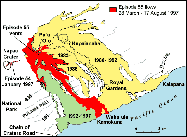 |
Figure 112. Map of recent lava flows from Kīlauea's east rift zone, 17 August 1997. Contours are in meters and the contour interval is approximately 150 m. Courtesy of the USGS Hawaiian Volcano Observatory. |
Beginning about 18 July another flow from South Shield followed a more easterly course toward the upper edge of the Royal Gardens subdivision. On 28 July the flow was burning into the forest edge 1.6 km above the subdivision. South Shield shut down early on 29 July, allowing the tubes to drain, but it resumed erupting that night. By the morning of the 30th lava had reoccupied the upper reaches of the tube; within two days the tube was reoccupied down to the coastal plain. Breakouts on 30 July formed channeled aa flows on the upper slopes of Pulama pali, sending new flows along the course of the earlier July flows.
Ocean entry of lava continued through 28 July. During 19-28 July surface flow activity on the coastal lava bench was extremely limited, with most flows occurring in lava tubes that broke out at the coast. At Pu`u `O`o the lava shield surrounding the main cone and a few of the spatter cones ringing its S side continued to expand. A fern glen was burned and partially covered by lava from the advancing flows. On 29 July the flow feeding the ocean entry ceased when its lava tube clogged. Soon thereafter, a new flow began moving downslope away from the vent.
South Shield has been the prolific producer of flows, including all large flows in July and early August. From 12-29 July a tube-fed flow from this vent entered the ocean at East Kamokuna and built a 60-m-wide lava bench ~350 m along the shoreline. The ocean entry was marked by a large steam plume and mild explosions that hurled spatter onshore, building two small littoral cones.
Activity continued during the last week of July with cyclic filling and lowering of the Pu`u `O`o lava pond. During the morning of 29 July, lava flowed over the E and W rims of the crater and down the sides of the cone for several hours. A blockage in the tube system caused the supply of lava entering the ocean to diminish. Lava stopped entering the ocean shortly after noon on 29 July. A new aa flow from a breakout above the blockage was several hundred meters W of the old flow, and the terminus of the new flow was 400 m from the ocean.
During the pause at the coast activity at Pu`u `O`o was continuous. Peter Mouginis-Mark and colleagues observed from the air a spectacular lava overflow from the pond occupying the E crater floor on 6 August that sent rapidly moving flows out of the SE side of the cone. The flows formed a lobate sheet that extended ~1.5 km. None of these flows were active for more than three hours. Lava began flowing into the sea again at the East Kamokuna entry on 4 August. A lobe from this flow branched at the foot of Pulama pali and advanced to within 800 m of Waha`ula Heiau, located 450 m E of the East Kamokuna entry. Vigorous activity within Pu`u `O`o lit the skies on the night of 7 August with moderate fountaining.
Lava covers Waha`ula Heiau in mid-August. On 8 August, lava buried a 300-m section of jeep road that provided access to the Royal Gardens subdivision. That lobe progressed seaward, slowly encroaching upon Waha`ula Heiau. On 11 August at 0124, lava began to overrun the heiau; flows were moving across the floor of the temple by 0300. By 0730 lava had covered most of the structures. It had been one of the few remaining major archaeological resources left in the Kalapana coastal section of the Park. The Waha`ula complex contained structures that tradition associated with the 13th-century high priest Pa`ao. A more recent structure in the complex was used by Kamehameha I and remained in use until 1819. Over the past 13 years thousands of significant archaeological features have been covered by lava flows from the Pu`u `O`o eruption.
Another Pu`u `O`o crater overflow event occurred on 12 August. Until at least 17 August lava continued to enter the sea at the Waha`ula entry and also ~900 m farther W, near Kamokuna. The lava built low benches and generated steam plumes. Activity continued at Pu`u `O`o through mid-August with cyclic filling and lowering of the lava pond. Sporadic fountaining was observed from the Crater Cone and the 55 spatter cone vents.
Kīlauea is one of five coalescing volcanoes that comprise the island of Hawaii. Historically its eruptions originate primarily from the summit caldera or along one of the lengthy E and SW rift zones that extend from the summit caldera to the sea. This latest Kīlauea eruption began in January 1983 along the E rift zone. The eruption's early phases, or episodes, occurred along a portion of the rift zone that extends from Napau Crater on the uprift (towards the summit) end to ~8 km E on the downrift (towards the sea) end. Activity eventually centered on what was later named Pu`u `O`o. Between January 1983 and December 1996, erupted lava totaled ~1.45 km3.
Geological Summary. Kilauea overlaps the E flank of the massive Mauna Loa shield volcano in the island of Hawaii. Eruptions are prominent in Polynesian legends; written documentation since 1820 records frequent summit and flank lava flow eruptions interspersed with periods of long-term lava lake activity at Halemaumau crater in the summit caldera until 1924. The 3 x 5 km caldera was formed in several stages about 1,500 years ago and during the 18th century; eruptions have also originated from the lengthy East and Southwest rift zones, which extend to the ocean in both directions. About 90% of the surface of the basaltic shield volcano is formed of lava flows less than about 1,100 years old; 70% of the surface is younger than 600 years. The long-term eruption from the East rift zone between 1983 and 2018 produced lava flows covering more than 100 km2, destroyed hundreds of houses, and added new coastline.
Information Contacts: Hawaiian Volcano Observatory (HVO), U.S. Geological Survey, PO Box 51, Hawaii Volcanoes National Park, HI 96718, USA (URL: https://volcanoes.usgs.gov/observatories/hvo/); Ken Rubin, Mike Garcia, and Peter Mouginis-Mark, Hawaii Center for Volcanology, University of Hawaii, Dept. of Geology & Geophysics, 2525 Correa Rd., Honolulu, HI 96822 USA (URL: http://www.soest.hawaii.edu/GG/hcv.html); Jim Martin, Superintendent, P.O. Box 52, Hawaii Volcanoes National Park, HI 96718-0052 (URL: http://www.nps.gov/havo/).