Report on Long Valley (United States) — November 1997

Bulletin of the Global Volcanism Network, vol. 22, no. 11 (November 1997)
Managing Editor: Richard Wunderman.
Long Valley (United States) Summary of 1996 activity
Please cite this report as:
Global Volcanism Program, 1997. Report on Long Valley (United States) (Wunderman, R., ed.). Bulletin of the Global Volcanism Network, 22:11. Smithsonian Institution. https://doi.org/10.5479/si.GVP.BGVN199711-323822
Long Valley
United States
37.7°N, 118.87°W; summit elev. 3390 m
All times are local (unless otherwise noted)
This report summarizes 1996 activity (Hill, 1996). More recent activity will be presented in subsequent reports.
During early 1996, a series of small earthquake swarms occurred in the S moat of the caldera between Convict Lake moraine and the SE margin of the resurgent dome. Swarm activity in the area gradually increased in intensity during February-March 1996, culminating with an earthquake swarm during 29 March-10 April, the most energetic in the caldera since January 1983 (SEAN 07:12); the swarm included 24 earthquakes of M 3 or greater. On 30 March two M 4.0 events occurred; on 1 April there was a M 4.1 event, the largest in the sequence. Altogether the swarm included over 1,600 locatable earthquakes (M >0.5) and had a cumulative seismic moment of ~5 x 10²² dyne-cm, the equivalent of a single M 4.8 earthquake. Instruments showed no unusual ground deformation associated with the swarm.
Earthquake activity within the caldera gradually slowed following the 29 March-10 April swarm through the remainder of April and May. Activity increased again in June with four bursts of seismicity at 5-day intervals during 9-25 June. Swarms on 9, 14, and 25 June were located near the SW margin of the resurgent dome (figure 19), near the junction of Highways 203 and 395; the swarm on 19-20 June was located at the SE margin of the resurgent dome (~2 km N of the airport). The largest earthquakes in these swarms were a M 2.6 event on 9 June, M 3.2 and M 3.5 events on 14 June, and a M 3.3 event on 19 June. The long-base tiltmeter, centered 1 km SE of the 19-20 June swarm, showed a 0.3 µrad tilt down to the NW coincident with that swarm.
 |
Figure 19. Earthquake epicenters in the Long Valley region during 1996. Courtesy of USGS. |
Small earthquake swarms on 30 July, and 7 and 9 August, were the last to occur within the caldera for the remainder of 1996; all were located near the SW margin of the resurgent dome. The caldera was relatively quiet during the last half of 1996 (figure 20), producing only occasional small earthquakes, all less than M 3.
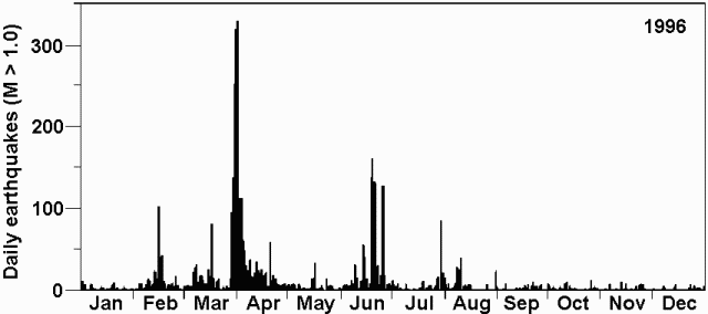 |
Figure 20. Daily number of earthquakes (M > 1.0) measured in 1996 at Long Valley Caldera. Courtesy of the USGS. |
Occasional long-period volcanic earthquakes continued to occur during 1996 at depths of 10-20 km beneath the Devils Postpile area SW of Mammoth Mountain. These events have become more frequent since their 1989 onset during a swarm beneath Mammoth Mountain (SEAN14:06). Minor volcano- tectonic earthquake activity in the shallow crust (<10 km depth) beneath Mammoth Mountain showed no significant change in rate or spatial distribution since 1989.
Long-term uplift and extensional deformation of the resurgent dome gradually slowed through the last half of 1996; this was defined by 2-color geodimeter measurements. The decrease in the resurgent dome's deformation rate and intra-caldera earthquake activity during the last half of 1996 was similar to the relative seismic quiescence and low deformation rates during 1984 to mid-1989. Continuous deformation monitoring showed no significant changes during 1996, with the exception of the 0.3 µrad tilt accompanying the 19-20 June earthquake swarm.
Dominant variations in carbon dioxide soil-gas concentrations in the tree-kill areas around Mammoth Mountain reflected the blanketing effect of snow during the winter months. Continuous CO2 monitors at Horseshoe Lake showed increased concentrations from early February through the end of April. Concentrations gradually returned to minimum values by mid-summer. The areas showing evidence of high CO2 soil-gas concentrations around the flank of Mammoth Mountain changed relatively slowly since 1991. In the late summer of 1995, there were seven areas of CO2-induced tree-kill scattered around the S, W, and N flanks of the mountain covering ~150 acres. A series of small collapse pits extending from the S-most tree-kill area at Horseshoe Lake merged with a crack in the bottom of Horseshoe Lake that was first detected in late September. Whether this system of shallow fractures is related to the anomalously high CO2 soil-gas concentration in the adjacent Horseshoe Lake tree-kill area has not been determined; however, the fracture system explained Horseshoe Lake's tendency to drain internally. A survey around Horseshoe Lake was planned in order to determine if the fracture system was associated with local deformation.
The 17 x 32 km Long Valley caldera lies E of the central Sierra Nevada, ~320 km E of San Francisco. The caldera formed ~730,000 years ago as a result of the Bishop Tuff eruption. Resurgent doming was followed by eruptions of rhyolite from the caldera moat and rhyodacite from the outer ring-fracture vents until ~50,000 years ago. Since then the caldera has remained thermally active, and in recent years has undergone significant deformation. Although distinct from Long Valley Caldera, both Inyo Craters and Mammoth Mountain are adjacent to it.
Reference. Hill, David P., 1996, Long Valley Caldera monitoring report (October- December 1996): U.S. Geological Survey, Volcano Hazards Program.
Geological Summary. The large 17 x 32 km Long Valley caldera east of the central Sierra Nevada Range formed as a result of the voluminous Bishop Tuff eruption about 760,000 years ago. Resurgent doming in the central part of the caldera occurred shortly afterwards, followed by rhyolitic eruptions from the caldera moat and the eruption of rhyodacite from outer ring fracture vents, ending about 50,000 years ago. During early resurgent doming the caldera was filled with a large lake that left strandlines on the caldera walls and the resurgent dome island; the lake eventually drained through the Owens River Gorge. The caldera remains thermally active, with many hot springs and fumaroles, and has had significant deformation, seismicity, and other unrest in recent years. The late-Pleistocene to Holocene Inyo Craters cut the NW topographic rim of the caldera, and along with Mammoth Mountain on the SW topographic rim, are west of the structural caldera and are chemically and tectonically distinct from the Long Valley magmatic system.
Information Contacts: David Hill, U.S. Geological Survey, MS 977, 345 Middlefield Rd., Menlo Park, CA 94025 USA (URL: https://volcanoes.usgs.gov/observatories/calvo/).