Report on Kilauea (United States) — December 1997

Bulletin of the Global Volcanism Network, vol. 22, no. 12 (December 1997)
Managing Editor: Richard Wunderman.
Kilauea (United States) Surge in activity on 15 January
Please cite this report as:
Global Volcanism Program, 1997. Report on Kilauea (United States) (Wunderman, R., ed.). Bulletin of the Global Volcanism Network, 22:12. Smithsonian Institution. https://doi.org/10.5479/si.GVP.BGVN199712-332010
Kilauea
United States
19.421°N, 155.287°W; summit elev. 1222 m
All times are local (unless otherwise noted)
During mid-December-5 January, Pu`u `O`o spilled lava across the crater floor more frequently than in previous weeks (BGVN 22:11). Prior to November, magma issued nearly continuously from the throat of the crater vent, but overflows diminished greatly during November-early December when lava remained mostly within the vent (figure 114). On 29 December, numerous spills resumed; however, none of the lava escaped from Pu`u `O`o crater.
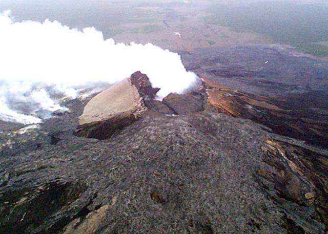 |
Figure 114. Oblique aerial photo looking SW across Pu`u `O`o on 4 December. Lava flows in foreground are E-directed overflows from August and October. Distance between N and S summits is 200 m. The crater vent lies at the base of the dense fume cloud in Pu`u `O`o crater. Courtesy of HVO. |
Lava from the S shield continued to travel in tubes to the coast and the eruption rate remained at ~500,000- 600,000 m3/day. Lava occasionally escaped from the tubes to form small new surface flows; a flow traveled at least 100 m on 30 December. During the first two weeks of January, several flows broke through the surface; one flow built a pad of lava measuring ~49 x 49 m and 2.1 m thick near the old visitor center. Breakouts from weak points in the tube roof were initiated by lava surges from the vent or by downtube blockages. During the breakouts, the weak sections of roof were rafted away by the outward flow of lava. Continuous, curtain-like steam plumes continued to rise where the lava, ~1,150°C, entered the sea along a 500-m-long section of coast.
The discharged lava continued to build benches beyond the low sea cliffs. At East Kamokuna, one of the sea entry sites, a bench collapse sometime during 23-26 December removed ~4.4 hectares along the coast. On 3 January, another bench collapse resulted in the loss of 1.6 hectares. After the second collapse, a large river-like lava flow broke onto the surface and flowed into the ocean.
On 10 January, Mike Garcia (University of Hawaii) reported observations of the lava sea entry at Kamokuna. Ribbon-like lava entered the sea in several places, solidified, and broke into pieces that were carried offshore. Observers noted that explosions at the site sent debris 25 m into the air. On the ground near the entry area, a coating of glassy debris had developed from recent lava-seawater explosions. A 3-m cliff from a recent bench collapse ~20 m from the coast and the formation of a new lava bench beyond the older cliff were observed. In addition, there was a new littoral cone resulting from lava spatter accumulation.
Sulfur dioxide emissions from the Pu`u `O`o vents remained high during the last two weeks of December, with rates as high as 7,000 tons/day. On 2 January, atmospheric sulfur dioxide levels reached 2 ppm, causing the National Park Service to close the visitor center for a few hours.
A rapid 2-hour pulse of inflation occurred at the summit starting around 1830 on 14 January. The activity was accompanied by numerous small earthquakes that signaled an abrupt movement of magma into the summit reservoir. Within minutes of the earthquakes, tiltmeters recorded more than 8 µrad of tilt (figure 115) on the rim of Kīlauea caldera. Despite the upward movement of magma, there was no surface eruption and the crater did not overflow. Immediately after the inflation event, deflation occurred as the new pulse of magma surged through the dike system of the E rift zone toward the Pu`u `O`o vents. The summit returned to its previous inflation level early on 16 January.
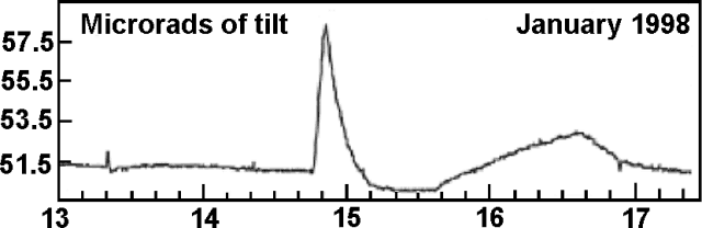 |
Figure 115. Tilt at the Uwehakuna summit tiltmeter during 13-17 January. Courtesy of HVO. |
At the Pu`u `O`o vents, activity increased substantially in response to the surge in magma supply. Lava fountains 15-20 m high and several surface flows were reported on the S flank of Pu`u `O`o. The flows were mostly confined to the older flow field (figure 116), but wood ash falling near Mauna Ulu indicated that some lava had burned vegetated areas. Although a strong glow during the event caused concern among nearby residents, no new areas were endangered. Some surface flows surged from openings in preexisting lava tubes; the sea entry sites remained active during the event. By 2200 on 15 January, the ocean entries were quiet, and a bench collapse had occurred at Kamokuna. Late on 16 January, lava returned to the tube system; on 17 January, sea entry conditions returned to pre-inflation levels.
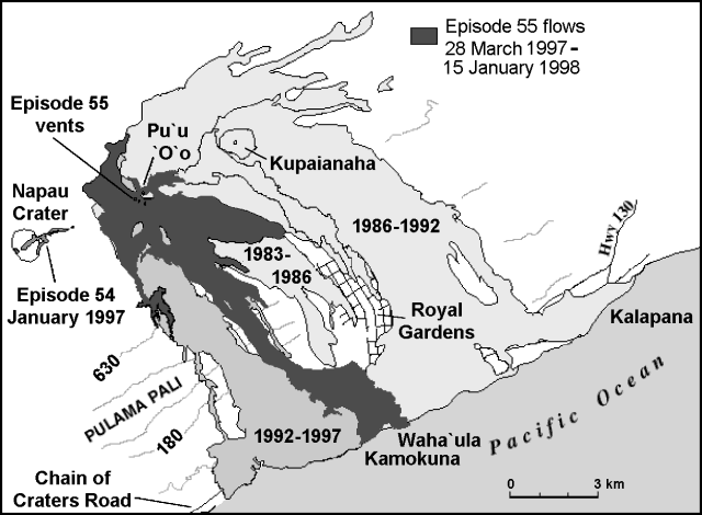 |
Figure 116. Distribution of lava flows from Kīlauea's E rift zone during 1983-1998 including flows from the surge of 15 January. Contours are in meters and the contour interval is approximately 150 m. Courtesy of HVO. |
Observations from the air on 15 January revealed that an a'a flow had issued from a vent S of Pu`u `O`o and moved downslope onto the base of Pulama pali. Two more surface flows advanced a short distance SW and a few hundred meters E of Pu`u `O`o. Several breakouts from tubes along the coastal plain caused small pahoehoe flows.
Kīlauea is one of five coalescing volcanoes that comprise the island of Hawaii. Historically its eruptions originated primarily from the summit caldera or along one of the E and SW rift zones that extend from the summit caldera to the sea. This latest eruption began in January 1983 along the E rift zone. The early phases, or episodes, occurred along a portion of the rift zone from Napau Crater on the uprift end to ~8 km E on the downrift end. Activity eventually centered on what was later named Pu`u `O`o. Between January 1983 and December 1996 the volume of erupted lava totaled ~1.45 km3. More than 223 hectares of new land have been added to the island and local communities have suffered more than $100 million in damages.
Geological Summary. Kilauea overlaps the E flank of the massive Mauna Loa shield volcano in the island of Hawaii. Eruptions are prominent in Polynesian legends; written documentation since 1820 records frequent summit and flank lava flow eruptions interspersed with periods of long-term lava lake activity at Halemaumau crater in the summit caldera until 1924. The 3 x 5 km caldera was formed in several stages about 1,500 years ago and during the 18th century; eruptions have also originated from the lengthy East and Southwest rift zones, which extend to the ocean in both directions. About 90% of the surface of the basaltic shield volcano is formed of lava flows less than about 1,100 years old; 70% of the surface is younger than 600 years. The long-term eruption from the East rift zone between 1983 and 2018 produced lava flows covering more than 100 km2, destroyed hundreds of houses, and added new coastline.
Information Contacts: Hawaiian Volcano Observatory (HVO), U.S. Geological Survey, PO Box 51, Hawaii Volcanoes National Park, HI 96718, USA (URL: https://volcanoes.usgs.gov/observatories/hvo/); Ken Rubin and Mike Garcia, Hawaii Center for Volcanology, University of Hawaii, Dept. of Geology & Geophysics, 2525 Correa Rd., Honolulu, HI 96822 USA (URL: http://www.soest.hawaii.edu/GG/hcv.html).