Report on McDonald Islands (Australia) — February 1998
Bulletin of the Global Volcanism Network, vol. 23, no. 2 (February 1998)
Managing Editor: Richard Wunderman.
McDonald Islands (Australia) The eruption of 1996-97 and its inferred lavas and tephra
Please cite this report as:
Global Volcanism Program, 1998. Report on McDonald Islands (Australia) (Wunderman, R., ed.). Bulletin of the Global Volcanism Network, 23:2. Smithsonian Institution. https://doi.org/10.5479/si.GVP.BGVN199802-234011
McDonald Islands
Australia
53.03°S, 72.6°E; summit elev. 230 m
All times are local (unless otherwise noted)
This report discusses field and geochemical observations that indicates activity at McDonald Island. The activity is inferred to have began in December 1996; it continued through early 1997.
Visual observations. During mid-December 1996, a pilot reported a vapor plume in the vicinity of Heard Island (figure 1). Initially, the report was thought to indicate an eruption of Big Ben, an intermittently active volcano on Heard Island that last erupted in 1993 (BGVN 17:12). Another report discussed a possible volcanic plume near Heard Island on 5 January 1997 (BGVN 22:01). A 15 January 1997 satellite image showed an extensive high-altitude linear cloud formation drifting E from near Heard Island; this activity was also assumed to be associated with Big Ben.
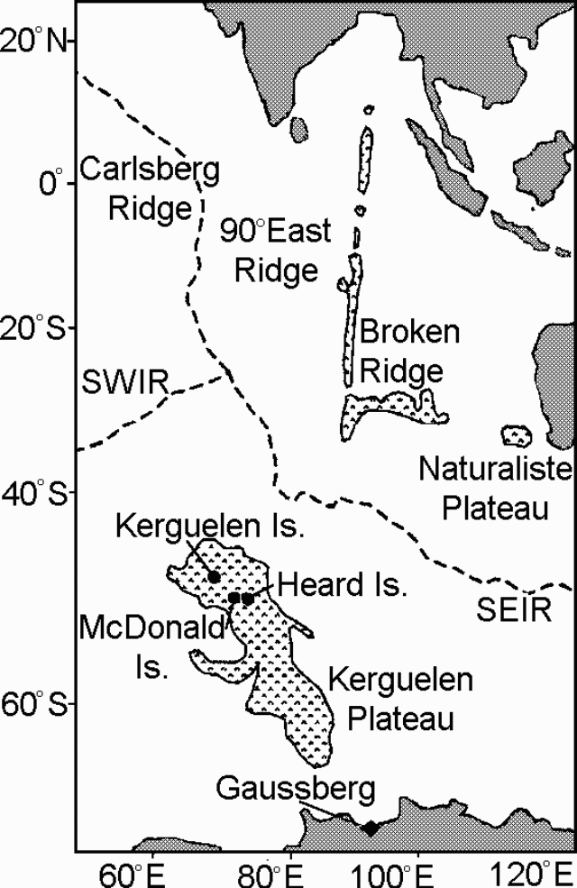 |
Figure 1. Location of Heard and McDonald Islands on the Kerguelen Plateau in the S Indian Ocean. "SWIR" refers to the Southwest Indian Ridge, "SEIR" to the Southeast Indian Ridge. Gaussberg is an isolated conical mountain of volcanic origin on the coast of Antarctica. Courtesy of K. Collerson. |
On 18 March 1997, the "RSV Aurora Australis," a ship en route to Heard Island, sailed within 7.4 km of McDonald Island. Observers on board reported seeing steam plumes emitted at high velocity from several point sources and from the fissure system on the island's steep N face between the topographic features known as The Needle, Samarang Hill, and Macaroni Hill (figure 2). They also saw a low, diffuse, white vapor plume extending SE from the island's N summit. Steam vented from a rubble-covered slope that possibly indicated a lava flow or pyroclastic deposit. Ken Collerson documented these observations on video tape (Collerson, 1997; Collerson and others, 1998).
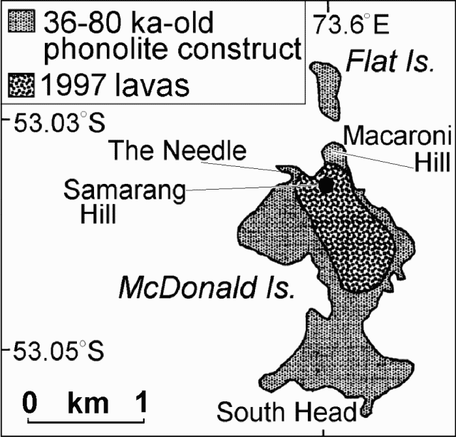 |
Figure 2. Sketch map of McDonald Island showing the new lavas in the vicinity of Samarang Hill. Courtesy of K. Collerson. |
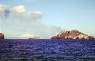
On 2 April, observers on the vessel "FV Austral Leader" saw vapor rising from the island's summit. The ship came within 2.6-4.6 km of McDonald Island for closer observation and confirmed steam venting similar to that observed on 18 March. Observations included "smoke" clouds rising from the summit and flanks of the N and middle parts of the island, possible lava flows traveling down gullies, and a yellow- green deposit (possibly sulfur) close to the source of the steam emissions. In addition, a diffuse white vapor plume from the N summit of the island was drifting N to NE. An early April photograph of steam venting appears on figure 3.
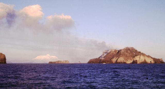 |
Figure 3. Photo of McDonald Island taken early April 1997 portraying steam venting at Samarang Hill (in the foreground). In the background resides glacier-draped Heard Island (44 km E of McDonald Island, with a summit elevation of 2,750 m). Copyrighted photo taken by Richard Williams and used with permission of the Australian Antarctic Division. |
Although observers never went ashore on McDonald Island during or after the eruption, Collerson estimated the extent of the lavas and fumarolic activity from visual observations, digital video images, and 35 mm photographs. A preliminary sketch map of new lavas appears on figure 2.
During 18-21 March geologists sampled Holocene lava flows on Heard Island. On beaches of the N Laurens Peninsula, they found fresh pumice ranging in size up to about 20 x 20 cm . The pumice was concentrated among other storm- transported debris a little distance above the normal surf zone and appeared to have been deposited by wave action. Light creamy green to pale gray in color, the pumice had angular, ovoid or flattened shapes and contained predominantly microphenocrysts and occasional phenocrysts visible to the naked eye. Lithic fragments were not observed.
On Heard Island, Big Ben's summit was usually obscured by clouds. The summit was visible on 20 March, however, and at this time no evidence of recent volcanic activity was observed at Mawson Peak, Big Ben's recently active crater (figure 4). Similarly no plume was seen coming from Heard when McDonald vented steam in early April (figure 3). In accord with these observations, scientists inferred that the December 1996-January 1997 volcanic activity attributed to Heard actually denoted activity at McDonald.
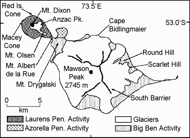 |
Figure 4. Map of Heard Island showing principal volcanic centers on both the Laurens and Azorella Peninsulas (see shaded boxes) and on Big Ben (the massif comprising the bulk of the SE part of the island). The beached pumice samples were collected at the N end of the Laurens Peninsula. Courtesy of K. Collerson. |
Satellite observations. Satellite images showing plumes similar to volcanic ash clouds extending E from the Heard Island area were reported to Australia's Bureau of Meteorology during the summers of 1996-97. Standard detection techniques did not confirm that the clouds were volcanic; however, several volcanologists and meteorologists studied the plumes and concluded that the clouds were probably not volcanic.
Meteorologists from the Tasmanian and Antarctic office of the Bureau of Meteorology suggested that the plumes were probably banner clouds, a type of cloud that often forms behind mountain peaks at high latitudes.
The ~600-km-long plumes seen repeatedly on the satellite images were not consistent with the prior activity of Heard Island; Heard Island was unlikely to produce large-scale eruptions and high-level ash clouds. However, McDonald Island was not ruled out as a possible source of volcanic plumes.
Geochemical studies. Researchers conducted major element and inductively coupled plasma mass spectrometer trace element analyses on the fresh pumice collected from Heard Island. The pumices were strongly alkaline with elevated incompatible element abundances. Although the results were similar to previous studies of McDonald Island phonolites, the pumices were generally more evolved, suggesting that they were derived from an extremely fractionated magma chamber. This conclusion was also supported by high- precision Th isotopic data. Extreme Na2O values for two samples, coupled with very high volatile contents and carbonatite-like HFSE and LILE abundances, suggested that some of the pumices contained an exsolved sodium- rich carbonate phase.
Sr, Nd, and Pb isotopic compositions of six samples of the fresh pumice collected on Heard Island were within the error of values reported for McDonald Island phonolites. The Sr, Nd, and Pb isotopic data for the pumices differed from other potential young volcanic sources in the southern hemisphere such as South Sandwich Islands, Marion Island, Iles Crozet, and the Ross Sea Igneous Province, and were thus interpreted as derived from McDonald Island.
References. LeMasurier, W.E., and Thompson, J.W., primary eds., 1990, Volcanoes of the Antarctic Plate and Southern Oceans, Antarctic Research Series: American Geophysical Union, Washington, D. C. (ISBN 0066-4634).
Collerson, K. D., Regelous, M., Frankland, R., Wendt, J. I., Kiernan, K., and Wheller, G., 1998, 1997 eruption of McDonald Island (southern Indian Ocean): new trace element and Th-Sr-Pb-Nd isotopic constraints on Heard-McDonald Island magmatism. Abstr. 14th Aust. Geol. Convention, Townsville, July 1998.
Collerson, K. D., Regelous, M., Wendt, J. I., and Wheller, G., 1998, 1997 eruption of McDonald Island (Southern Indian Ocean): new trace element and Th-Sr-Pb-Nd isotopic constraints on Heard-McDonald Island magmatism: Earth Planet Sci. Lett (in prep.)
Collerson, K. D., 1997, Field studies at Heard and McDonald Island in March 1997: unpublished Australian National Antarctic Research Expedition (ANARE) report.
Geological Summary. Historical eruptions have greatly modified the morphology of the McDonald Islands, located on the Kerguelen Plateau about 75 km W of Heard Island. The largest island, McDonald, is composed of a layered phonolitic tuff plateau cut by phonolitic dikes and lava domes. A possible nearby active submarine center was inferred from phonolitic pumice that washed up on Heard Island in 1992. Volcanic plumes were observed in December 1996 and January 1997 from McDonald Island. During March 1997 the crew of a vessel that sailed near the island noted vigorous steaming from a vent on the N side of the island along with possible pyroclastic deposits and lava flows. A satellite image taken in November 2001 showed the island to have more than doubled in area since previous reported observations in November 2000. The high point of the island group had shifted to the McDonald's N end, which had merged with Flat Island.
Information Contacts: Kenneth Collerson, Department of Earth Sciences, University of Queensland, Brisbane, Queensland 4072, Australia; Kevin Kiernan, Department of Geography and Environmental Sciences, University of Newcastle, Newcastle, New South Wales 2300, Australia; Richard Williams, Australian Antarctic Division, Channel Highway, Hobart, Tasmania, Australia; Andrew Tupper, Northern Territory Regional Forecasting Centre, Bureau of Meteorology, P. O. Box 735, Darwin, Northern Territory 0801, Australia.