Report on Axial Seamount (Undersea Features) — February 1998
Bulletin of the Global Volcanism Network, vol. 23, no. 2 (February 1998)
Managing Editor: Richard Wunderman.
Axial Seamount (Undersea Features) Hydrothermal plumes detected on research cruise suggest lava extrusion
Please cite this report as:
Global Volcanism Program, 1998. Report on Axial Seamount (Undersea Features) (Wunderman, R., ed.). Bulletin of the Global Volcanism Network, 23:2. Smithsonian Institution. https://doi.org/10.5479/si.GVP.BGVN199802-331021
Axial Seamount
Undersea Features
45.95°N, 130°W; summit elev. -1410 m
All times are local (unless otherwise noted)
An episode of intense seismicity occurred at Axial Seamount during 25 January-early February (see map, BGVN 23:01). In response, a team of scientists sailed aboard Oregon State University's research vessel Wecoma during 9-16 February. The following report summarizes the preliminary findings of the Axial Response Team (ART). Although the team found evidence of extensive new venting at Axial Volcano, vigorous event plumes were absent.
Despite wind gusts and high seas, the team deployed 8 ocean bottom hydrophones on 10 February around the intersection of Axial's S rift zone and summit caldera. In addition, the team made measurements of water conductivity, temperature, depth, and light attenuation at 16 sites (figure 4). The light- attenuation measurements were used to estimate particle loading in the hydrothermal plumes.
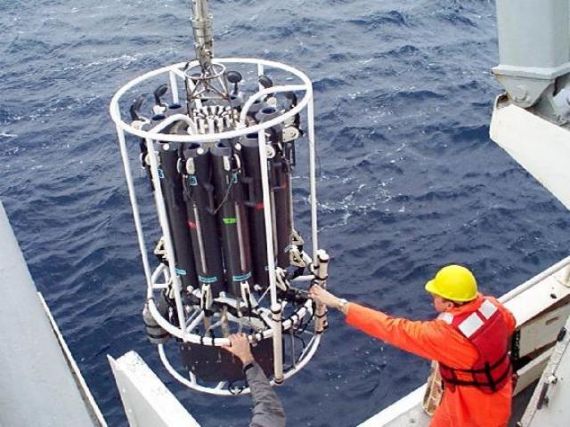 |
Figure 4. Deployment of a water-sampling instrument package during the ART cruise. Ron Greene of Oregon State University is on the right. Courtesy of R. Embley. |
Some instruments had been previously deployed and were in place on the sea floor before and during the event, including two volcanic system monitors and an array of three temperature sensor/current-meter moorings along the rectangular caldera's SE corner at the center of the summit epicenter locations. Earlier pre-event data on plume distribution and chemistry were gathered during a research cruise in the summer of 1997, a time when very weak plumes were present close to the sea floor.
Hydrothermal discharge from Axial seamount's summit was roughly an order of magnitude greater than before the eruption. The caldera's S end was filled with plumes that had temperature anomalies approaching 0.2°C and intense light-attenuation coefficients (~0.2/m); these plumes rose at least 200 m above the ocean bottom. The temperature anomalies were about twice as great as those seen after the 1993 CoAxial eruption (BGVN18:07). The plume was tracked ~20 km SW, where it remained as strong as in the caldera. The areal pattern of integrated relative light-attenuation (figure 5) indicated that the plume drifted steadily SW, in agreement with past current-meter readings. Both methane and hydrogen gas concentrations were higher during the cruise than in previous measurements, reaching concentrations as high as 600 nM and 200 nM, respectively. Background concentrations for methane are typically <1 nM.
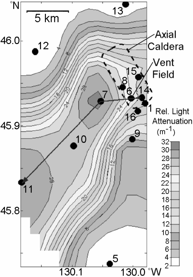 |
Figure 5. Plan view showing contours of relative light-attenuation that has been integrated over depths of 1.1-1.5 km. Dots indicate water sampling stations; the heavy line indicates the transect shown in figure 6. Increased suspended particles cause greater light-attenuation. Courtesy of NOAA/PMEL. |
Vertical profiles gathered at the water sampling stations revealed hydrothermal signal maxima occurring at shallow (1.2-1.4 km) and/or deep (1.4-1.5 km) locations. A very strong plume at the S end of the caldera at a depth of ~1.4-1.5 km was detected on 12 February. The plume's peak (~1.47 km depth) had a light- attenuation coefficient >0.440/m, a value significantly greater and found at shallower water depths than previously detected over Axial Caldera. Increased mass concentration of particles suspended in the water column causes greater light-attenuation values. Water samples collected from the plume had very high levels of methane (~600 nM); hydrogen gas concentration measured ~4 nM. The profile taken over the vent field (at station 6) revealed a very strong plume with considerable vertical structure that extended ~1.2 km to the sea floor. The plume showed light attenuation (figure 6) and temperature anomalies with maxima occurring at both 1375- and 1425-m depth.
No event plumes were detected directly above the caldera. The team may have arrived after any event plumes had drifted away from the site. The few wispy plumes ~50-80 m thick found almost 600 m above the caldera were possible event plume remnants. No sign of venting was detected along the length of the S rift zone; a dike intrusion was thought to have occurred there during the seismic swarm of late January 1998. The lack of plumes differed from the 1993 CoAxial eruption, where the intrusion was associated with long plumes.
A small but distinct hydrothermal signal at 1.2-1.3 km depth was detected on 15 February ~18 km S of the caldera, within the central seismic cluster. The signal was interpreted as a plume remnant. Water sampling revealed methane concentrations of 5-20 nM but no elevated H2 concentrations. This indicated either that the original hydrothermal source was low in H2 or that the H2 had been lost to microbial oxidation.
A NE-SW transect of relative light attenuation (figure 6) suggested that the plume thickened and shallowed downstream from the caldera. The changes in intensity along the transect may have arisen from one or more causes, including fluctuations in water speed, temporal changes in the intensity of venting, and initial venting of more buoyant fluids.
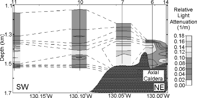 |
Figure 6. Cross-section showing relative light attenuation in and adjacent to Axial's caldera. Water-sampling sites (eg., 10, 11, etc.) are labeled along the top axis. The line of the cross section appears on figure 5. Courtesy of NOAA/PMEL. |
Particles in water samples from stations 11 and 1 (figure 5) were studied by scanning electron microscope (SEM). Samples from station 11 contained many angular glass shards up to 95 micrometers in diameter. Many of the shards had precipitated halite particles attached to them; precipitation of halite coatings on altered glass surfaces was consistent with heating seawater to >400°C at 1.5 km depth. Similar coatings were found on basaltic particles from the 1993 CoAxial eruption.
Many small particles with high iron concentrations were also observed. Although these particles were of similar size to iron oxides from past eruptive sites, their shapes were more angular than the typically rounded, globular shapes seen in the past. Chemical analysis showed that these particles also contained halides and a higher than usual ratio of phosphorus to iron. Analysis of particles from station 1 showed abundant elemental sulfur. These observations were taken to suggest a lava eruption on the SE caldera floor.
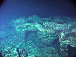
Axial Volcano rises 700 m above the mean level of the ridge crest and is the most magmatically robust and seismically active site on the Juan de Fuca Ridge between the Blanco Fracture Zone and the Cobb offset. The summit is marked by an unusual rectangular-shaped caldera (3 x 8 km, figure 5) that lies between the two rift zones. The caldera is defined on three sides by a boundary fault of up to 150 m relief. Organisms have colonized the hydrothermal vents near the caldera faults and the rift zones. Following the initial discovery of venting N of the caldera in 1983, a concentrated mapping and sampling effort was made in the mid-late 1980s.
Geological Summary. Axial Seamount rises 700 m above the mean level of the central Juan de Fuca Ridge crest about 480 km W of Cannon Beach, Oregon, to within about 1,400 m of the ocean surface. It is the most magmatically and seismically active site on the Juan de Fuca Ridge between the Blanco Fracture Zone and the Cobb offset. The summit is marked by an unusual rectangular-shaped caldera (3 x 8 km) that lies between two rift zones and is estimated to have formed about 31,000 years ago. The caldera is breached to the SE and is defined on three sides by boundary faults of up to 150 m relief. Hydrothermal vents with biological communities are located near the caldera fault and along the rift zones. Hydrothermal venting was discovered north of the caldera in 1983. Detailed mapping and sampling efforts have identified more than 50 lava flows emplaced since about 410 CE (Clague et al., 2013). Eruptions producing fissure-fed lava flows that buried previously installed seafloor instrumentation were detected seismically and geodetically in 1998 and 2011, and confirmed shortly after each eruption during submersible dives.
Information Contacts: Jim Cowen, Department of Oceanography, School of Ocean and Earth Science and Technology, University of Hawai'i at Manoa, 1000 Pope Road, Honolulu, HI USA 96822; Ed Baker, NOAA Pacific Marine Environmental Laboratory (PMEL), 7600 Sand Point Way N.E., Seattle, WA USA 98115; Bob Embley, NOAA Pacific Marine Environmental Laboratory (PMEL), 2115 SE OSU Drive, Newport, OR 97365 USA (URL: http://www.pmel.noaa.gov/).