Report on Kilauea (United States) — June 1998

Bulletin of the Global Volcanism Network, vol. 23, no. 6 (June 1998)
Managing Editor: Richard Wunderman.
Kilauea (United States) Pause in lava flow during May; benches collapse during May-July
Please cite this report as:
Global Volcanism Program, 1998. Report on Kilauea (United States) (Wunderman, R., ed.). Bulletin of the Global Volcanism Network, 23:6. Smithsonian Institution. https://doi.org/10.5479/si.GVP.BGVN199806-332010
Kilauea
United States
19.421°N, 155.287°W; summit elev. 1222 m
All times are local (unless otherwise noted)
Episode 55 of Kīlauea's east rift zone eruption continued during May and June. Thick volcanic fume in the inner crater of Pu`u `O`o often prevented scientists from observing details of activity there. They did observe that over several-hour periods, lava would emerge from one or more vents, sometimes reaching to within 10-30 m of the crater rim, and then suddenly drain back into the vents. Such fill and drain cycles occurred irregularly.
A new crater floor pit developed at the base of the E crater wall on 7 May. Such pits form by undermining; magma beneath the crater floor erodes parts of the solidified crust. Where the crust becomes thin, the floor collapses to form a pit, which may become a new vent or a place where lava can drain back into the main magma conduit system beneath the cone. These pits periodically overflow and spill small lava flows across the crater floor. Generally, these flows remain contained within the crater of Pu`u `O`o; the most recent crater overflow occurred in January 1998. Observers also noted a series of new cracks curving around several adjacent pits on the SE flank of the Pu`u `O`o cone. These cracks suggested this part of the cone was subsiding and may develop into a single large pit.
Lava erupted quietly from vents on the SW flank of Pu`u `O`o and traveled about 12 km through lava tubes to the coast. Typically, between 300,000 and 600,000 m3 of lava entered the ocean every day at the Waha`ula and Kamokuna entry points. A temporary pause in the supply of magma on 19-20 May permitted lava within the tube system to drain completely so that lava ceased flowing into the ocean. After lava began re-entering the tube system during the evening of 20 May, several "leaks" (breakouts) occurred. The most voluminous breakouts began early in the morning of 21 May on the steep slope of the fault scarp (pali) between 335 m and 610 m.
During a pause, the roof and walls of drained tubes are prone to collapse. When lava reenters the tube system, blockages or irregularities in the tube cause the lava to back up and escape (breakout) through skylights or other weak points. A prolonged period of surface-flow activity resulted in lateral expansion of the lava-flow field, because the middle of the field is usually higher than the sides and new surface flows are diverted to the edges. During this most recent pause, however, the tube system quickly accommodated nearly all of the lava. The Kamokuna entry point resumed abruptly at about 1240 on 21 May. Sixteen similar pauses have occurred since episode 55 began in March 1997.
The Kamokuna entry was the more active outlet. New land built outward from a large littoral cone, which formed on the seaward edge of the new bench (figure 121), and frequently collapsed into the ocean. Following such a collapse sometime during 1-4 May, a new bench began to form, growing to ~ 90 m wide by 2 June. Two additional significant collapses occurred on 11 June and 6 July. The large collapse event on 6 July removed about 3.7 ha of new land. Bench collapses are life endangering because numerous explosions ensue when the hot lava interacts with the ocean water; the reaction can spark lightning and roiling clouds. Accordingly, the National Park Service restricted access to the area.
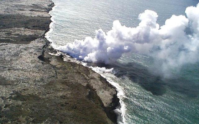 |
Figure 121. An aerial view of Kīlauea on 2 July looking to the NE across the lava bench at Kamokuna entry point. The shot was taken just days before the entire bench collapsed. The large littoral cone lies in the left center of image (below the left tip of the steam plume). Courtesy of HVO. |
Kīlauea is one of five coalescing volcanoes that comprise the island of Hawaii. Historically its eruptions originate primarily from the summit caldera or along one of the lengthy E and SW rift zones that extend from the caldera to the sea. The latest Kīlauea eruption began in January 1983 along the east rift zone. The eruption's early phases, or episodes, occurred along a portion of the rift zone that extends from Napau Crater on the uprift (towards the summit) end to ~8 km E on the downrift end (towards the sea). Activity eventually centered on the area and crater that was later named Pu`u `O`o.
Geological Summary. Kilauea overlaps the E flank of the massive Mauna Loa shield volcano in the island of Hawaii. Eruptions are prominent in Polynesian legends; written documentation since 1820 records frequent summit and flank lava flow eruptions interspersed with periods of long-term lava lake activity at Halemaumau crater in the summit caldera until 1924. The 3 x 5 km caldera was formed in several stages about 1,500 years ago and during the 18th century; eruptions have also originated from the lengthy East and Southwest rift zones, which extend to the ocean in both directions. About 90% of the surface of the basaltic shield volcano is formed of lava flows less than about 1,100 years old; 70% of the surface is younger than 600 years. The long-term eruption from the East rift zone between 1983 and 2018 produced lava flows covering more than 100 km2, destroyed hundreds of houses, and added new coastline.
Information Contacts: Hawaiian Volcano Observatory (HVO), U.S. Geological Survey, PO Box 51, Hawaii Volcanoes National Park, HI 96718, USA (URL: https://volcanoes.usgs.gov/observatories/hvo/); Ken Rubin and Mike Garcia, Hawaii Center for Volcanology, University of Hawaii, Dept. of Geology & Geophysics, 2525 Correa Rd., Honolulu, HI 96822 USA (URL: http://www.soest.hawaii.edu/GG/hcv.html).