Report on Soufriere Hills (United Kingdom) — July 1998

Bulletin of the Global Volcanism Network, vol. 23, no. 7 (July 1998)
Managing Editor: Richard Wunderman.
Soufriere Hills (United Kingdom) Relatively large pyroclastic flows on 3 July; ash venting
Please cite this report as:
Global Volcanism Program, 1998. Report on Soufriere Hills (United Kingdom) (Wunderman, R., ed.). Bulletin of the Global Volcanism Network, 23:7. Smithsonian Institution. https://doi.org/10.5479/si.GVP.BGVN199807-360050
Soufriere Hills
United Kingdom
16.72°N, 62.18°W; summit elev. 915 m
All times are local (unless otherwise noted)
On 3 July, after several months of reduced activity, a 2.5-hour sequence of large pyroclastic flows took place at Soufriere Hills. Ash clouds reached heights of 9-12 km before drifting N and depositing fine ash over the inhabited part of the island. New deposits extended the Tar River delta significantly, adding ~0.25 km2 to its area, but not extending it seaward. Winds carried the cloud N, disturbing previously unaffected houses in the Long Ground area. The new materials were typical block-and-ash deposits, associated with fine surge deposits and ash-cloud deposits.
The 3 July pyroclastic flows marked the first major event at Soufriere Hills since dome growth ended in mid-March (BGVN 23:04). The dome had reached a volume of 120 x 106 m3 (the maximum observed throughout the eruption) and a summit height of 1,031 m. The minor pyroclastic flows of previous months (BGVN 23:04 and 23:05) were consistent with mechanical collapse of the very large and unstable dome and were therefore of no great significance. Given the duration of low levels of activity, it was conjectured that the current volcanic crisis might be waning, with important implications for the residents of the island and its administration. Because the 3 July pyroclastic flows apparently represented a re-escalation of activity, the Montserrat Volcano Observatory (MVO) has examined the events and deposits to investigate their significance.
Precursor events. There were no obvious precursors to the eruption. However, possibly related factors included a felt earthquake at 1704 on 25 June centered under Barbuda, and a series of small-to-moderate pyroclastic flows commencing at 1229 on 30 June and lasting 30-40 minutes. It may be significant that the events of 3 July coincided with the passage of a tropical wave, a period of bad weather and heavy rain.
Observations. Abrupt onset of activity was detected by the MVO seismic network at 0302 on 3 July, so opportunities for visual observations were limited. During the first half hour, there were reports from several localities in the W and N of the island of 'stones' and ash falling. At 0400 NOAA satellites detected a large ash column reaching altitudes of 9-12 km moving ENE. As a result of wind shear, the lower part of the plume was blown NW, which resulted in significant ashfall over the N of the island. Light ashfall was also recorded on Nevis and St. Kitts.
At 0422 an observer at Jack Boy Hill reported pyroclastic flows descending the Tar River valley, with abundant lightning and with an ash cloud drifting and rising over the center of the island. Reporters on the W of the island recorded heavy ashfall in the Belham Valley (figure 41), at Salem, and at Woodlands. Thunder and lightning were observed at the front of the ash plume as it headed W over the sea. At 0450 pyroclastic flows were observed at the Tar River delta; the deposits were steaming strongly at 0518. Winds from the S deposited 0.5-1 mm of ash over the entire N end of the island.
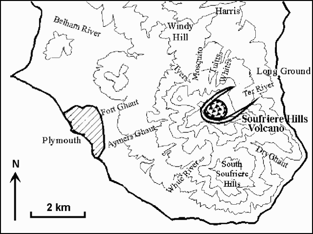 |
Figure 41. Map of the southern part of Montserrat indicating some areas referred to in the text. Courtesy of MVO. |
Although residents reported falling 'stones,' examination of the deposits revealed no pumice clasts. A maximum 2-mm-thick layer of fine ash was recorded in Salem with lithics and crystals up to 3 mm in size from MVO to the S. Most of the ash fell as accretionary lapilli all over the island, reaching diameters of up to 4 mm. These large lapilli may account for the reports of 'stones'. Heavy rain following the event precluded detailed studies of the deposits.
A helicopter flight at 0700 confirmed that pyroclastic flows had reached the Tar River delta and entered the sea. In the upper Tar River valley, flows were channeled down its S side; lower down they spread out over both sides of the valley. The N slopes of Roche's Mountain and Perche's Estate were eroded and there were indications that small amounts of material, including some ballistics, had overtopped the ridge causing impact scars on steep slopes and starting small fires. Surges associated with the passage of the pyroclastic flow left significant deposits of fine ash in the area of the Tar River estate house, and for the first time since the onset of the crisis the southern parts of Long Ground village were affected. Trees and shrubs were scorched, but no houses caught fire, nor was there any evidence of high velocities associated with the surges. Surge deposits extended to about 400 m N of the Tar River delta.
Small rockfall deposits were observed on the White River flanks of the dome, but there was no activity in Tuitt's, Mosquito, or Tyer's ghauts. Ash continued to drift W during the morning. A smaller event at about 1407 produced a dark cloud about 3 km high, depositing further ash on the Woodlands, Salem, Old Towne, and Olveston areas, but not farther N. This may have been a weak explosion or a small pyroclastic flow. A further 1 mm of fine ash accumulated in the Woodlands and Salem areas.
An observation flight at 1500 on 3 July revealed a large scar on the SE flanks of the dome, with chutes leading down against the N scarp of Perche's mountain and the S edge of the Tar River valley. A large volume had been lost from the dome (later estimated visually to be 15% of total dome volume). The prominent 50-m-high spine at Galway's dome was not visible due to steam and ash in the summit region, but craggy peaks were observed on the S and NE rims of the scar left by the collapse event. There was no evidence of changes on the other flanks of the dome. Strong fumarolic activity was observed along a clearly defined NE-trending, linear fracture 50-100 m in length within the new scar. Several distinct vents along this fracture gave off white steam; one appeared to be tinged with yellow elemental sulfur. To the W of this a dark mass was intermittently visible through the steam: its dark color may have resulted from steam condensation.
An observation flight on 10 July in clear conditions showed that the collapse scar had the shape of an extremely steep sided, long canyon extending deep back into the dome: it was not possible to determine its westernmost limit, but it must have cut through most of the dome. There was no evidence of renewed dome growth.
Associated seismicity. Beginning at 1229 on 30 June signals indicating a moderate-sized pyroclastic flow lasted ~40 minutes. After this event daily rockfall signals increased from an average of 2/day for June (including 11 on 30 June) continuing with 13 and 8 signal on 1 and 2 July.
On 3 July another, much larger pyroclastic-flow signal started at 0302 and lasted ~2.5 hours. The maximum amplitude of this signal was attained immediately after the onset and lasted for 30 seconds. It was greater than that for the flow on 30 June and several times greater than the last big flows down the Tar River valley in May 1997 (BGVN 22:05).
Spectral analysis of the high amplitude signal at the onset suggests that it was not generated by an explosive event similar to those seen during August and September 1997 (BGVN 22:08). It has been suggested, however, that a phreatic explosion may have been involved.
Deposits. New block-and-ash deposits from the 3 July event covered the entire Tar River delta, and new surge deposits extended over the N of the valley into Long Ground (figure 42). Comparisons between aerial photos of the deposit taken on 24 June, 3, 4, and 6 July show a significant increase in area on the N and S of the delta, but no significant increase in the E. The N side of the delta may have extended by up to 250 m; the S side, by only 30-50 m. The maximum width of the delta (along its base) is now ~1.9 km, tapering to 1 km seaward, extending 700 m off shore. This indicates a total area for the delta of 1 km2, an increase of about 0.25 km2.
 |
Figure 42. Diagramatic map showing the deposits produced by the 3 July 1998 dome collapse and some vertical sections of the delta. North is to the right; heavy solid line is pre-eruption shoreline. Stratigraphic abbreviations are as follows: "BAF," block-and-ash flow; "Accr. ash," the layer of ash rich in accretionary structures probably produced by a secondary explosion when the hot mobile material reached the sea; "Alter." (in section 5), the red alteration probably due to interaction with the sea; and "Ground surge," the often reverse-graded layer of very fine ash found at the base of the block-and-ash flow. The white area on the fan corresponded to old block-and-ash flow deposits. Courtesy of MVO. |
An observation flight on 3 July showed intense white and brownish steaming on the N delta and much weaker white steaming on the S. A number of different lobes of various tones and textures were interpreted as successive pulses from different parts of the dome. Overall, the S area appeared light gray and the N appeared brownish.
Deposits along the beach lines of the delta were later visited. Dry material was extremely hot, steaming from small vents locally. The upper layers consisted of very fine grained, dusty surge deposits reaching up to ~0.5 m in thickness, lacking large clasts. This material was very mobile and small jets fountained when disturbed for sampling. Bubbling mud/ash vents up to 0.4 m in diameter were also distributed irregularly over the front of the delta. Underlying the fine surge deposits was a typical block-and-ash deposit of indeterminate thickness, with clasts typically of a few centimeters diameter, though some meter-sized boulders were visible on the surface of the deposit nearby.
Sampling carried out on the delta showed a prevalence of blocks from the dome, associated with a small proportion of pumices of varying density and vessiculation. A few blocks exhibiting bread-crust structure were found in the S delta. The differences in color seen from the air were conspicuous on the ground. The N part appears much finer than the S.
Hydrothermal alteration was observed in both areas. The top of the surge deposit showed some evidence of alteration, forming a slightly more resistant crust, perhaps as a result of steam from below. In the S this alteration crust is much harder. Part of this alteration is the result of a post-depositional process (as evidenced by yellow, white, and red staining on the surface); part may be due to pre-depositional processes, evidenced by individual discolored blocks of different size located on non-altered areas.
Exploratory sections made on 9 July through the delta deposit showed that the S area consists of a new block-and-ash flow deposit ~10 cm thick on top of deposits from an older block-and-ash flow. Close to the sea a significant layer of alteration (about 6 of 13 cm) is also evident in the deposit. The N of the delta shows a surge layer ~10 cm thick on top of the new block-and-ash flow deposit of up to 50 cm. Sections 1 and 2 (close to the original coast line) also hosted a layer of accretionary ash, probably due to secondary explosions when the flow reached the sea. This is consistent with the brownish steam seen to the N of the delta a few hours after the collapse. Section 2, the most complete section observed, shows the presence of a 15 cm thick layer of very fine ash at the base. The new deposits are probably thickest in the central part of the delta, but it was not possible to obtain thickness data there. Temperatures of the deposits were taken at several places (table 30).
Table 30. Temperature measurements in 3 July 1998 deposits at Soufriere Hills. Courtesy of MVO.
| Measurement Date | Time | Delta Area | Location | Depth (cm) | Temperature (°C) |
| 06 Jul 1998 | 1445 | Northern | 5 m from deposit edge | 4 | 100 |
| 06 Jul 1998 | 1445 | Northern | 5 m from deposit edge | 50 | 300 |
| 06 Jul 1998 | 1445 | Northern | 6 m from edge, inside fluidized area | 80 | 298 |
| 06 Jul 1998 | 1445 | Northern | 8 m from deposit edge | 4 | 100 |
| 06 Jul 1998 | 1445 | Northern | 8 m from deposit edge | 50 | 255 |
| 07 Jul 1998 | 1400 | Northern | 5 m from deposit edge | 4 | 65 |
| 07 Jul 1998 | 1400 | Northern | 5 m from deposit edge | 50 | 195 |
| 07 Jul 1998 | 1400 | Northern | 5 m from deposit edge | 100 | 319 |
| 07 Jul 1998 | 1400 | Northern | 20 m from deposit edge | 4 | 76 |
| 07 Jul 1998 | 1400 | Northern | 20 m from deposit edge | 50 | 193 |
| 07 Jul 1998 | 1400 | Northern | 20 m from deposit edge | 70 | 238 |
| 06 Jul 1998 | 1445 | Southern | 5 m from deposit edge | 4 | 132 |
| 06 Jul 1998 | 1445 | Southern | 5 m from deposit edge | 50 | 360 |
| 06 Jul 1998 | 1445 | Southern | 10 m from edge | 4 | 120 |
| 06 Jul 1998 | 1445 | Southern | 10 m from edge | 50 | 375 |
| 07 Jul 1998 | 1400 | Southern | 5 m from deposit edge | 4 | 117 |
| 07 Jul 1998 | 1400 | Southern | 5 m from deposit edge | 50 | 337 |
| 07 Jul 1998 | 1400 | Southern | 5 m from deposit edge | 70 | 391 |
| 07 Jul 1998 | 1400 | Southern | 10 m from deposit edge | 4 | 115 |
| 07 Jul 1998 | 1400 | Southern | 10 m from deposit edge | 50 | 360 |
| 07 Jul 1998 | 1400 | Southern | 10 m from deposit edge | 70 | 238 |
Subsequent events. The pyroclastic flows of 3 July were followed by heightened rock-fall and volcano-tectonic earthquakes until 1407, when there was further high-amplitude seismic signal. This time the signal lasted only 10 minutes and the maximum amplitude was similar to that of the flow on 30 June. Analysis of the most recent event shows that the first 30 seconds were dominated by a 2.4-Hz harmonic signal. This, combined with observations of the color and ascent rate of the ash cloud, suggested an explosive component, which produced a low, dark ash cloud that drifted NW depositing ash on Salem and Woodlands.
On 5 July there were three episodes of ash venting, which produced weak ash plumes to about 3 km that drifted W over Plymouth. The first two occurred at about 0330 and 0500 lasting about 30 minutes each. The third event at 1030 was observed from Salem and lasted 1.75 hours with new, dense pulses of dark gray ash every 5 minutes.
The following week, there continued to be elevated numbers of rock-fall signals, volcano-tectonic earthquakes, and intervals of tremor associated with ash venting from the scar left by the large collapse.
COSPEC observations. COSPEC observations resumed on 5 July. Although the long interval since the last observations (BGVN 22:10) makes comparisons difficult, SO2 emission rates were clearly elevated, measuring 1,500-3,000 metric tons/day between 5 and 11 July. Although the high flux after the event may have been due to the effects of scattering by fine dust and aerosols in the plume (increasing the effective optical-path length), fluxes one week after the collapse were still significantly higher than during comparable periods earlier in the eruption. This may indicate a change in the magmatic source of the gas, or a change in the degassing regime caused by the depressurizing of a large part of the dome and associated changes in the underlying hydrothermal system. Reports of strong H2S odors from the volcano over previous months may also be related to a cooler, wetter hydrothermal system.
Interpretations and conclusions. Because the dome had stopped growing in mid-March, and in the absence of any clear seismic or other precursors, the 3 July event was initially interpreted as a large mechanical dome collapse- not triggered by fresh dome growth. Given the continued low level of activity, this may still be the correct interpretation. Seismic records suggested a sudden initial collapse followed by continued erosion of the scar. This inference is supported by the very long, deep collapse scar, which extends across much of the dome. Although there are no close parallels from Montserrat itself, it is possible that the high- amplitude seismic signal at the onset of the event was due to a phreatic explosion.
There is little evidence to indicate renewed dome growth. The high SO2 fluxes are problematical in the absence of fluxes taken immediately prior to the collapse. There may have been a change in the hydrothermal system, which brought about the conditions leading to collapse.
The difference in temperature, texture, and color between the new deposits in N and S areas of the delta suggests that they have been affected by different processes: the N area was affected by block-and-ash flows and surges; the S area, only by block-and-ash flows. It is likely that the large area affected by surges on the N flanks of the valley, including parts of Long Ground village, was the result of S winds during the emplacement of the pyroclastic flows.
Acknowledgments. The following scientists contributed to these studies: Costanza Bonadonna and Rob Watts, Department of Geology, University of Bristol; Peter Francis, Department of Earth Sciences, Open University; Richard Luckett and Colin Walker, Montserrat Volcano Observatory; Gill Norton and K. Rowley, British Geological Survey; Richard Robertson, Seismic Research Unit, University of the West Indies.
Geological Summary. The complex, dominantly andesitic Soufrière Hills volcano occupies the southern half of the island of Montserrat. The summit area consists primarily of a series of lava domes emplaced along an ESE-trending zone. The volcano is flanked by Pleistocene complexes to the north and south. English's Crater, a 1-km-wide crater breached widely to the east by edifice collapse, was formed about 2000 years ago as a result of the youngest of several collapse events producing submarine debris-avalanche deposits. Block-and-ash flow and surge deposits associated with dome growth predominate in flank deposits, including those from an eruption that likely preceded the 1632 CE settlement of the island, allowing cultivation on recently devegetated land to near the summit. Non-eruptive seismic swarms occurred at 30-year intervals in the 20th century, but no historical eruptions were recorded until 1995. Long-term small-to-moderate ash eruptions beginning in that year were later accompanied by lava-dome growth and pyroclastic flows that forced evacuation of the southern half of the island and ultimately destroyed the capital city of Plymouth, causing major social and economic disruption.
Information Contacts: Montserrat Volcano Observatory (MVO), c/o Chief Minister's Office, PO Box 292, Plymouth, Montserrat, West Indies (URL: http://www.mvo.ms/).