Report on Popocatepetl (Mexico) — August 1998

Bulletin of the Global Volcanism Network, vol. 23, no. 8 (August 1998)
Managing Editor: Richard Wunderman.
Popocatepetl (Mexico) Moderate, intermittent ash emissions continue
Please cite this report as:
Global Volcanism Program, 1998. Report on Popocatepetl (Mexico) (Wunderman, R., ed.). Bulletin of the Global Volcanism Network, 23:8. Smithsonian Institution. https://doi.org/10.5479/si.GVP.BGVN199808-341090
Popocatepetl
Mexico
19.023°N, 98.622°W; summit elev. 5393 m
All times are local (unless otherwise noted)
Following moderate eruptive outbursts in mid-August (BGVN 23:07), Popocatépetl returned to the low-level activity that has prevailed since May 1998. A few minor increases in ash emissions during subsequent weeks were noted by CENAPRED in the daily internet log.
Frequent moderate emissions took place on 24 August. The largest events occurred at 0402 and 1215. A small plume from a steam fumarole drifted to the SW. At 1553 a tectonic earthquake of magnitude M 2 occurred, and was located 2.5 km SE of the crater at a depth of 3.7 km. At 1613 40 minutes of high-frequency tremor of variable amplitude began, accompanied by the emission of ash, gas, and steam in a column rising 1,500 m above the summit. Activity diminished to normal by the next day.
Isolated, moderately large exhalations of short duration were noted on 28 August. Some of these exhalations were accompanied by small puffs of ash, steam, and gas. At 1807 a high-frequency tremor signal was recorded followed 2 minutes later by mild explosions lasting 8 minutes. Visibility was limited throughout the day by intense meteorological cloudiness, but presumably the explosions caused a gas, steam, and low-density-ash column that was blown NE. After this event activity returned to previous levels.
A slight increase in activity early on 31 August consisted of several moderate, but short, exhalations and some small high-frequency tremor episodes. The largest occurred at 0418 followed 6 minutes later by an exhalation. The tremor continued for about 15 minutes. At that time glow from inside the crater could be seen on the summit video camera. During the night several rockfalls were recorded.
After several days of low activity, a moderately large exhalation occurred at 0539 on 8 September. Its intense phase lasted 6 minutes, followed by a 15-minute-long tremor. Although the volcano was obscured by cloud, Doppler radar indicated ash close to the crater (figure 26). Reports were received of slight ashfall to the SW at Huequechula, Puebla. At 0844 another exhalation, much smaller than the one recorded earlier, lasted only 2 minutes; no ash emission was detected. At 1439 a low-frequency tremor signal started and persisted until 2100. Although scientists suggested that this signal might herald more intense and explosive exhalations in the next hours or days, similar to last April, activity decreased the next day.
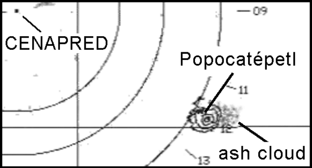 |
Figure 26. Radar image of an eruption plume from Popocatépetl taken at 0548 on 8 September 1998. The source of the radar is at CENAPRED headquarters located at the center of the circles. The volcano is 60 km SE at the right side of the image. The ash cloud is identified by a gray spot close to the volcano. Image courtesy of CENAPRED. |
Geological Summary. Volcán Popocatépetl, whose name is the Aztec word for smoking mountain, rises 70 km SE of Mexico City to form North America's 2nd-highest volcano. The glacier-clad stratovolcano contains a steep-walled, 400 x 600 m wide crater. The generally symmetrical volcano is modified by the sharp-peaked Ventorrillo on the NW, a remnant of an earlier volcano. At least three previous major cones were destroyed by gravitational failure during the Pleistocene, producing massive debris-avalanche deposits covering broad areas to the south. The modern volcano was constructed south of the late-Pleistocene to Holocene El Fraile cone. Three major Plinian eruptions, the most recent of which took place about 800 CE, have occurred since the mid-Holocene, accompanied by pyroclastic flows and voluminous lahars that swept basins below the volcano. Frequent historical eruptions, first recorded in Aztec codices, have occurred since Pre-Columbian time.
Information Contacts: Servando De la Cruz-Reyna1,2, Roberto Quaas1,2 Carlos Valdés G.2, and Alicia Martinez Bringas1. 1Centro Nacional de Prevencion de Desastres (CENAPRED) Delfin Madrigal 665, Col. Pedregal de Santo Domingo,Coyoacan, 04360, México D.F. (URL: https://www.gob.mx/cenapred/); 2Instituto de Geofisica, UNAM, Coyoacán 04510, México D.F., México.