Report on El Chichon (Mexico) — August 1998
Bulletin of the Global Volcanism Network, vol. 23, no. 8 (August 1998)
Managing Editor: Richard Wunderman.
El Chichon (Mexico) Changes in hydrothermal activity noticed in April
Please cite this report as:
Global Volcanism Program, 1998. Report on El Chichon (Mexico) (Wunderman, R., ed.). Bulletin of the Global Volcanism Network, 23:8. Smithsonian Institution. https://doi.org/10.5479/si.GVP.BGVN199808-341120
El Chichon
Mexico
17.3602°N, 93.2297°W; summit elev. 1150 m
All times are local (unless otherwise noted)
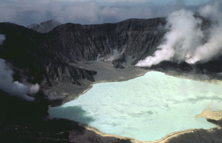
Slight variations in lake water temperature and migration of thermal fields on the crater floor were noticed during an April 1998 visit. Erosion had started to form deeply incised gullies in the crater walls, producing small rockfalls around the crater. Rockfall activity continued along the S crater wall as in 1995 (BGVN 20:05). The latest rockfall deposit contained blocks up to 3 m in diameter.
According to bathymetric data obtained during the April visit, the average depth of the lake is only 1.5 m. On the lake bottom several funnel-shaped areas about 5-6 m below the surface discharged bubbling gases. No elemental sulfur was found in samples of lake sediments. The surface temperature of the lake is very uniform, and even above the gas funnels did not exceed 35°C. Such uniformity may indicate that the lake water is not significantly influenced by underlying magma and is highly affected by seasonal variations in precipitation and ambient temperature. The lake's surface maintained the same elevation in May 1996 and January 1997, but during the April 1998 visit it was 1 m higher.
Hydrothermal activity inside the crater in April was compared to observations made in January 1997. Since then, two boiling pools on the NW side of the crater had dried out, but three new large boiling pools 5-10 m in diameter had appeared 100 m to the S. The boiling pools gave off much more vapor than earlier. The Soap Pool, a boiling spring that had an outflow rate of ~20 kg/s in 1996-97, had decreased to an outflow of only 6-7 kg/s of very saline boiling water. A large area around this pool was covered by a crust of a white salt precipitated from the pool water.
Discharge estimates for the volcano-hydrothermal system were made in April: springs on the southern slopes of the volcano and the Soap Pool inside the crater discharged at least 300 kg/s of thermal water. The steam output from the crater (from fumaroles with elevated temperatures) did not exceed 20 kg/s. Temperature and chlorine concentration of these springs are recorded in table 3.
Table 3. Temperatures and chlorine concentrations of thermal water springs at El Chichón as measured in April 1998. Data courtesy of Instituto de Geofisica, UNAM.
| Spring | Temperature | Chlorine (mg/kg of H2O) |
| Agua Caliente | 71°C | 2,000 |
| Agua Salada | 51°C | 1,600 |
| Agua Tibia | 55°C | 1,200 |
| Soap Pool | 98°C | 15,000 |
El Chichón is located in a heavily forested mountainous area in Chiapas, 670 km ESE of México City. No historical eruptions were known before the Plinian eruption in 1982, although solfataras and hot springs were present in the summit area and on the flanks. The 1982 explosions destroyed the summit dome creating a 1 km wide crater.
Geological Summary. El Chichón is a small trachyandesitic tuff cone and lava dome complex in an isolated part of the Chiapas region in SE México. Prior to 1982, this relatively unknown volcano was heavily forested and of no greater height than adjacent non-volcanic peaks. The largest dome, the former summit of the volcano, was constructed within a 1.6 x 2 km summit crater created about 220,000 years ago. Two other large craters are located on the SW and SE flanks; a lava dome fills the SW crater, and an older dome is located on the NW flank. More than ten large explosive eruptions have occurred since the mid-Holocene. The powerful 1982 explosive eruptions of high-sulfur, anhydrite-bearing magma destroyed the summit lava dome and were accompanied by pyroclastic flows and surges that devastated an area extending about 8 km around the volcano. The eruptions created a new 1-km-wide, 300-m-deep crater that now contains an acidic crater lake.
Information Contacts: Yuri Taran, Jose Luis Macias, Juan Manuel Espindola, and Nicholas Varley, Instituto de Geofisica, UNAM, Ciudad Universitaria, Coyoacan 04510, México D.F., México.