Report on Kilauea (United States) — November 1998

Bulletin of the Global Volcanism Network, vol. 23, no. 11 (November 1998)
Managing Editor: Richard Wunderman.
Kilauea (United States) Continuing flow from Pu`u `O`o; major bench collapse
Please cite this report as:
Global Volcanism Program, 1998. Report on Kilauea (United States) (Wunderman, R., ed.). Bulletin of the Global Volcanism Network, 23:11. Smithsonian Institution. https://doi.org/10.5479/si.GVP.BGVN199811-332010
Kilauea
United States
19.421°N, 155.287°W; summit elev. 1222 m
All times are local (unless otherwise noted)
A significant collapse of the lava bench on the coast SE of Kīlauea occurred in early December. Lava continued to flow into the sea via a tube from the Pu`u `O`o vent, and a pit at the vent continued to grow.
A large part of the active lava delta on the SE coast collapsed into the sea sometime between 1200 on 10 December and 0930 on 11 December. A comparison between the shoreline as mapped on 11 and 24 November (figure 125), and the shoreline on 11 December, showed that ~5.8 hectares (ha) was lost. The missing shoreline included ~3.4 ha of land built since August and ~2.4 ha built W of the current lava-entry area (indicated by the steam cloud at the top of figure 125) between 1992 and 1997. Judging from observations of earlier bench collapses, the collapsed area most likely slid into the sea in several segments over a period of tens of minutes to several hours.
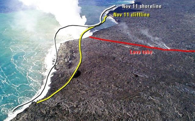 |
Figure 125. View of the Kīlauea lava entry point area looking S on 24 November 1998. Courtesy HVO; photograph by J. Kauahikaua. |
The eruption of Pu`u `O`o continued in November as lava flowed to the sea through a lava tube that developed on the coastal plain after a major pause in magma supply to the vent on 12-14 August (BGVN 23:08). Another brief pause occurred on 7-8 November (pause #21 of the current eruptive episode) leading to several small `a`a and pahoehoe flows on the coastal plain, none of which reached the sea. Scientists measured a slight increase in the discharge of lava from the tube system—from 3/day in late October to just over 400,000 m3/day in early December. Dense volcanic fumes continued to obscure various pits within Pu`u `O`o most of the time, but sloshing sounds of lava degassing could be heard from the crater rim.
A new pit that developed high on the S flank of Pu`u `O`o about one year ago enlarged significantly in 1998, and recent measurements of cracks around the edge of the pit showed that its walls were slumping slowly into the pit.
Geological Summary. Kilauea overlaps the E flank of the massive Mauna Loa shield volcano in the island of Hawaii. Eruptions are prominent in Polynesian legends; written documentation since 1820 records frequent summit and flank lava flow eruptions interspersed with periods of long-term lava lake activity at Halemaumau crater in the summit caldera until 1924. The 3 x 5 km caldera was formed in several stages about 1,500 years ago and during the 18th century; eruptions have also originated from the lengthy East and Southwest rift zones, which extend to the ocean in both directions. About 90% of the surface of the basaltic shield volcano is formed of lava flows less than about 1,100 years old; 70% of the surface is younger than 600 years. The long-term eruption from the East rift zone between 1983 and 2018 produced lava flows covering more than 100 km2, destroyed hundreds of houses, and added new coastline.
Information Contacts: Hawaiian Volcano Observatory (HVO), U.S. Geological Survey, PO Box 51, Hawaii Volcanoes National Park, HI 96718, USA (URL: https://volcanoes.usgs.gov/observatories/hvo/); Ken Rubin and Mike Garcia, Hawaii Center for Volcanology, University of Hawaii, Dept. of Geology & Geophysics, 2525 Correa Rd., Honolulu, HI 96822 USA (URL: http://www.soest.hawaii.edu/GG/hcv.html).