Report on Grimsvotn (Iceland) — November 1998
Bulletin of the Global Volcanism Network, vol. 23, no. 11 (November 1998)
Managing Editor: Richard Wunderman.
Grimsvotn (Iceland) Subglacial eruption near site of 1996 outburst flood
Please cite this report as:
Global Volcanism Program, 1998. Report on Grimsvotn (Iceland) (Wunderman, R., ed.). Bulletin of the Global Volcanism Network, 23:11. Smithsonian Institution. https://doi.org/10.5479/si.GVP.BGVN199811-373010
Grimsvotn
Iceland
64.416°N, 17.316°W; summit elev. 1719 m
All times are local (unless otherwise noted)
On 18 December an eruption occurred within the caldera of the subglacial Grímsvötn volcano, 10 km S of the 1996 eruption that resulted in a catastrophic flood. Scientists quickly investigated; the information that follows is from the Nordic Volcanological Institute (NVI).
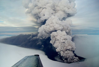
Eruptive activity. The eruption began at 0920 on 18 December. Ten minutes later a plume (figure 4) was observed that eventually rose 10 km above the Vatnajökull glacier and persisted throughout the day. The plume could be seen from Reykjavik, 200 km W. Winds deflected the plume, causing tephra fallout onto the glacier up to 50 km SE. The London Volcanic Ash Advisory Center issued aviation notices later that day and throughout the eruption.
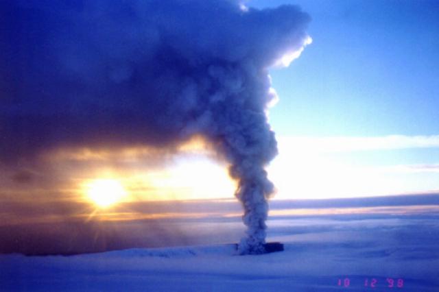 |
Figure 4. Photo of the eruption plume from Grímsvötn as it appeared from an aircraft on 18 December 1998. Courtesy of NVI; photo by Karl Grönvold. |
The eruption was preceded by a mild increase in seismicity for several weeks. A small earthquake swarm began at 2200 on 17 December and a sharp increase in earthquake activity began at 0330 on 18 December. This latter activity was replaced by continuous tremor at 0920, marking the beginning of the eruption. The Icelandic Meteorological Office and the Science Institute monitored seismicity during the eruption.
Vents were located along a 1,300-m-long E-W oriented fissure on the S caldera fault, similar to eruptions in 1934 and 1983, at the foot of Mt. Grímsfjall (which rises ~300 m above the flat ice shelf of the Grímsvötn subglacial lake). The eruption penetrated the caldera lake and its ice shelf, from ice/water depth of ~100 m. Activity was most vigorous at one crater, but several other craters on the short eruptive fissure were also active with less frequent explosions.
The eruption was slightly less vigorous on 19 December. The plume was continuous, but somewhat lower, rising to 7-8 km. Tephra continued to fall SE. A small part of the Grímsvötn ice shelf next to the eruption site had melted without raising the water level of the caldera lake significantly. Activity was mostly limited to one crater.
An overflight on 20 December from 1045 to 1215 revealed variable activity. The eruption plume extended to 7 km altitude. Initially the plume was light-colored, and narrow at its base. Later the ash content of the plume greatly increased, and the plume turned black. It collapsed down to 1-2 km, created a base surge, and Mt. Grímsfjall disappeared into an ash cloud.
Photographs from 27 December showed intermittent eruptive activity between 1124 and 1240. The plume was discontinuous, fed by intermittent crater activity. It rose to a maximum of 4.5 km and distributed ash near the crater; bombs up to 0.5 m in diameter were ejected onto Grímsfjall. The eruption has resulted in the formation of a tephra ring that lies partly on ice, but its inner part is likely to be made completely of ash overlying bedrock.
The eruption ended on 28 December. Continuous tremor recorded at the Grimsfjall seismograph, 3 km from the eruption site, stopped at 1050 on 28 December. Small tremor bursts were recorded for another 3 hours, but activity stopped completely at 1400.
This eruption was located 10 km S of the 1996 eruption in Vatnajökull (Gudmundsson and others, 1997), which caused a catastrophic outburst flood from the glacier. This time no major flood ensued because only a small amount of the Grímsvötn ice shelf near the eruption site melted, and water did not flow towards the Grímsvötn caldera lake.
Chemical analyses of ash. The ash analyzed fell during 1000-1200 on 20 December in Suðursveit, ~60 km SE of Grímsvötn. The ash was well sorted with an average grain size of 0.05 mm and density of ~2.7 g/cm3. The areal density of ash fall was estimated at 93 g/m2. The ash was aphyric; the glass composition (table 1) can be compared with Grímsvötn ash samples from earlier this century. The composition is similar to earlier samples; however, the recent sample is slightly less evolved, with higher MgO/FeO, Al2O3, and CaO, but lower TiO2. The composition was markedly different from more evolved samples from the 1996 eruption or most of the samples available from the neighboring Bárðarbunga volcanic system.
Table 1. Microprobe analyses of the glass phase from the 20 December 1998 Grímsvötn eruptions (standard deviation in parentheses) and two Grímsvötn hyaloclastites. The analyses from the 1983, 1934, 1922, and 1903 eruptions are from Grönvold and Johannesson (1984). The analyses of the hyaloclastites are from Heikki Makipaa (1978). All analyses are in weight percent. Courtesy NVI.
| Eruption / Sample Description | SiO2 | TiO2 | Al2O3 | FeO (total) | MnO | MgO | CaO | Na2O | K2O | P2O5 |
| Dec 1998 | 50.46 (0.55) | 2.55 (0.05) | 13.94 (0.29) | 12.90 (0.13) | 0.23 (0.01) | 5.72 (0.20) | 11.00 (0.28) | 2.71 (0.09) | 0.48 (0.03) | 0.35 (0.12) |
| 1983 G83-2 | 50.30 | 2.98 | 12.80 | 14.00 | 0.20 | 5.00 | 9.71 | 2.58 | 0.45 | 0.32 |
| 1983 G83-1 | 50.50 | 3.02 | 12.60 | 14.40 | 0.26 | 4.96 | 9.55 | 2.62 | 0.51 | 0.36 |
| 1934 G34 | 50.30 | 3.08 | 12.80 | 13.40 | 0.26 | 5.14 | 9.92 | 2.56 | 0.52 | 0.38 |
| 1922 G22 | 50.10 | 3.06 | 12.80 | 13.90 | 0.20 | 5.24 | 10.20 | 2.47 | 0.40 | 0.30 |
| 1903 G03 | 49.80 | 2.92 | 13.10 | 13.60 | 0.20 | 5.45 | 10.30 | 2.53 | 0.38 | 0.27 |
| HM22 Hyaloclastite glass | 49.92 | 2.59 | 14.46 | 12.95 | 0.23 | 5.42 | 10.09 | 2.98 | 0.31 | 0.32 |
| HM23 Hyaloclastite glass | 49.49 | 2.49 | 14.10 | 12.91 | 0.23 | 5.12 | 10.56 | 2.80 | 0.45 | 0.25 |
| HM22, HM23 Whole-rock | 52.00 | 2.57 | 12.85 | 12.99 | 0.22 | 9.90 | 5.56 | 2.93 | 0.51 | 0.32 |
| 1934 G34 Whole-rock | 49.34 | 3.10 | 14.23 | 13.96 | 0.23 | 9.95 | 4.84 | 3.32 | 0.48 | 0.39 |
| Svíahnúkur caldera rim hyaloclastite | 50.65 | 1.96 | 15.31 | 11.40 | 0.16 | 11.34 | 6.73 | 1.50 | 0.43 | 0.39 |
The potential chemical pollution of the fallout ash was tested by leaching a batch of ash with 6.7 times its mass of de-ionized water. The pH of the leachate was 5.12; the water-soluble components were as follows (mg leachate / kg ash): SiO2, 7.2; Na, 315.3; K, 32.7; SO4, 557.8; F, 346.5; Cl, 366.2.
References. Grönvold, K., and Jóhannesson, H., 1984, Eruption in Grímsvötn 1983, course of events and chemical studies of the tephra: Jökull, 34:1-11.
Gudmunsson, M., Sigmundsson, F., and Björnsson, H., 1997, Ice-volcano interaction of the 1996 Gjálp subglacial eruption, Vatnajökull, Iceland: Nature, v. 389, p. 954-957.
Geological Summary. Grímsvötn, Iceland's most frequently active volcano in recent history, lies largely beneath the vast Vatnajökull icecap. The caldera lake is covered by a 200-m-thick ice shelf, and only the southern rim of the 6 x 8 km caldera is exposed. The geothermal area in the caldera causes frequent jökulhlaups (glacier outburst floods) when melting raises the water level high enough to lift its ice dam. Long NE-SW-trending fissure systems extend from the central volcano. The most prominent of these is the noted Laki (Skaftar) fissure, which extends to the SW and produced the world's largest known historical lava flow in 1783. The 15 km3 basaltic Laki lavas were erupted over 7 months from a 27-km-long fissure system. Extensive crop damage and livestock losses caused a severe famine that resulted in the loss of one-fifth of the population of Iceland.
Information Contacts: Karl Grönvold and Freysteinn Sigmundsson, Nordic Volcanological Institute (NVI), Grensásvegur 50, 108 Reykjavík, Iceland (URL: http://nordvulk.hi.is/); Pall Einarsson, Science Institute, University of Iceland; Icelandic Meteorological Office, Reykjavík, Iceland (URL: http://en.vedur.is/).